1
201 KAR 18:150
Standards Of Practice
2
201 KAR 18:150. Standards of practice.
RELATES TO: KRS 322.290(1)(a), (2)(f)
STATUTORY AUTHORITY: KRS 322.290(2)(f)
NECESSITY, FUNCTION, AND CONFORMITY: KRS 322.290(1)(a) authorizes the
board to administer KRS Chapter 322. KRS 322.290(2)(f) requires the board to
establish standards of practice. This administrative regulation establishes standards of
practice for professional land surveyors in Kentucky.
Section 1. Definitions.
(1) "Boundary" means the perimeter of a parcel or tract of land.
(2) "Boundary survey" means a survey to:
(a) Determine either the entire perimeter of a parcel or tract of land, or a portion
of the perimeter of a parcel or tract of land;
(b) Establish or reestablish a parcel or tract of land’s corner or monument; or
(c) Divide or consolidate the parcels or tracts of land surveyed.
(3) "Completion Date of Survey" means the last date when all the monuments were
either found or set for the plat of survey area.
(4) "Corner" means a point that designates a change in the direction of the boundary.
(5) "Field work" means that work performed by a land surveyor on the ground in
connection with the parcel or tract being surveyed.
(6) "GIS" means Geographic Information System and is any system that captures,
stores, analyzes, manages, and presents data that are linked to a land location and is
the merging of cartography and database technology.
(7) "GNSS" means Global Navigation Satellite Systems. The standard generic term for
satellite navigation systems that provide autonomous geo-spatial positioning with global
coverage.
(8) "GPS" means the United States NAVSTAR Global Positioning System, a space-
based global navigation satellite system that when used in conjunction with suitable
GPS receivers and processing software, provides reliable location information to the
level of precision specified in this administrative regulation, in all weather and at all
times and anywhere on the earth where there is an unobstructed line of sight to four (4)
or more GPS satellites.
3
(9) "Meander point" means a survey point or station marking a change in direction along
a linear feature such as a watercourse, ridge, road, or cliff.
(10) "Monument" means an artificial, manmade or natural object that is used as, or
presumed to occupy, any of the following locations:
(a) A property corner;
(b) A point on the boundary; or
(c) A reference point.
(11) "Plat" means any representational drawing created by a land surveyor reflecting
work falling within the definition of land surveying.
(12) "Plat of survey" means a finished drawing of a completed survey of a parcel or tract
of land, used to depict the final results of a boundary survey, drawn on a dimensionally
stable media suitable for reproduction of copies.
(13) "Point on Line" means a point on a boundary line other than a corner.
(14) "Reference monument" means a monument:
(a) That does not occupy the same defined position as a property corner; and
(b) Whose relationship to the corner of the property is established by bearing and
distance to the actual corner.
(15) "Relative Positional Accuracy" means the value expressed in feet that represents
the uncertainty due to random errors in measurements in the location of any point on a
survey relative to any other point on the same survey at the 95 percent confidence level.
(16) "Retracement survey" means a boundary survey of an existing parcel or tract of
land.
Section 2. Application.
(1) Boundary surveys. The standards of practice established in Sections 1 through 12 of
this administrative regulation:
(a) Shall apply to the work product related to:
1. Boundary surveys used for the purpose of creating, depicting, or
locating interests in land;
2. Partial surveys;
3. Boundary surveys of leases; and
4. Deed descriptions written by professional surveyors;
4
(b) Shall be the minimum standards of practice for a professional land surveyor;
and
(c) Shall not limit the establishment of more stringent standards of practice for a
professional land surveyor by:
1. An agency;
2. An owner;
3. A contract; or
4. The professional land surveyor.
(d) Shall not apply to surveys to determine or define political areas including
historical, school, fire, voting, utility or magisterial districts, municipal or county
limits, or governmental permit limits.
(2) Land surveying work other than boundary surveys. The standards of practice
established in Sections 1, 2, 3, and 13 of this administrative regulation:
(a) Shall apply to the work of the professional land surveyor falling within the
definition of land surveying, but not falling within the definition of a boundary
survey;
(b) Shall be the minimum standards of practice for a professional land surveyor
for that work; and
(c) Shall not limit the establishment of more stringent standards of practice for a
professional land surveyor by:
1. An agency;
2. An owner;
3. A contract; or
4. The professional land surveyor.
Section 3. Compliance.
(1) Failure to comply with this administrative regulation shall constitute misconduct,
gross negligence, incompetence, or a combination of these violations in the practice of
professional land surveying.
(2) A professional land surveyor shall not represent that:
(a) A boundary survey determines land ownership; or
(b) A boundary survey provides more than evidence of rights in land; or
(c) Land ownership can be established by any survey
5
Section 4. Actual Boundary Survey.
(1) The marks and monuments on the ground as found and verified, or as set by a
professional land surveyor shall constitute the actual boundary survey.
(2) Any plat of survey shall accurately represent the actual
boundary survey.
(3) Record research and field work required by the provisions of this administrative
regulation:
(a) Shall be used by a professional land surveyor to determine the location of the
boundary of the property to be surveyed; and
(b) Shall not be used by a professional land surveyor to determine title.
Section 5. Record Research.
In performing a boundary survey, a professional land surveyor shall conduct
research to obtain and evaluate the following:
(1) The present and relevant historical record descriptions of:
(a) Each parcel to be surveyed; and
(b) Each adjoining parcel;
(2)The description of the physical monument that represents each property corner;
(3) All other relevant documents of record including deeds and prior plats and surveys;
(4) All other relevant public agency records including tax maps, GIS maps, and
topographic maps; and
(5) Any other available data or documents pertinent to the boundary survey.
Section 6. Field Work.
A professional land surveyor shall thoroughly:
(1) Search for the physical monuments that represent each boundary corner;
(2) Search for other physical monuments set out in the description of the parcel or tract
of land being surveyed;
(3) Gather, analyze, and document evidence of occupation and physical evidence;
6
(4) Gather, analyze, and document relevant parol evidence; and
(5) Compare evidence discovered by field work, with that discovered by record
research, to determine or reestablish the boundary of the tract or parcel of land being
surveyed.
Section 7. Measurement Specifications.
(1) Every measurement made as a part of a boundary survey shall comply with the
following:
(a) The standards for accuracy and precision established by the provisions of this
section; or
(b) Standards for accuracy and precision that exceed the standards established
by the provisions of this section but are:
1. Requested by the client;
2. Required by contract;
3. Required by the agency or entity to which the plat of survey is to be
presented; or
4. Deemed desirable or necessary by the land surveyor.
(2) A professional land surveyor shall conduct measurements with instruments and
equipment that are properly:
(a) Adjusted;
(b) Maintained; and
(c) Calibrated to meet the appropriate tolerance required for the classification of
survey as specified in subsection (5) of this section.
(3) A boundary survey shall be conducted utilizing a method of measurement that
achieves the appropriate minimum tolerance specified in subsection (5) of this section.
(4) A boundary survey for platting or describing a parcel or tract of land shall be
classified as "Urban" or "Rural".
(a) An Urban survey shall:
1. Consist of urban or suburban land; and
2. Include a parcel or tract of land lying within, or adjacent to:
a. A city or town limit;
b. A commercial business area;
c. An industrial area; or
d. A residential area that is outside a city or town limit and contains
subdivided lots smaller than five (5.0) acres.

7
(b) A Rural survey shall apply to all land not classified as "Urban".
(5) Table of Specifications by Class: Classification of Surveys.
Urban
Rural
Remarks
Unadjusted
Closure
(Minimum)
1:10,000
1:5,000
Loop or Between
Control
Monuments
Angular
Closure
(Maximum)
15" N
30" N
N = Number of
Angles in
Traverse
Accuracy
of
Distances
+/-
0.05’+100
PPM
+/-
0.10’+200
PPM
100PPM=1:10,000
Relative
Positional
Accuracy
+/-
0.05’+100
PPM
+/-
0.10’+200
PPM
Section 8. Global Positioning Systems.
(1) It shall be acceptable practice to incorporate the use of survey grade GPS
equipment into any boundary survey. The accuracy and precision of all measurements
made with that equipment shall, at a minimum, meet all other accuracy and precision
standards required otherwise by law or rules under Section 7(5) of this administrative
regulation. If using GPS equipment in the course of a boundary survey, the professional
land surveyor shall state on the face of the plat of survey, the following:
(a) A note stating what portion (or all) of the boundary survey was performed
using GPS equipment;
(b) The type of GPS equipment used, including manufacturer and model number,
and whether single or dual frequency receivers were used;
(c) The type of GPS survey that was performed, including static, real time
kinematic ("RTK"), network adjusted real time kinematic, etc.;
(d) A note that discloses the precision of the GPS work done, either in relative
positional accuracy, or vector closure.
(e) A statement identifying the horizontal datum, the vertical datum, and the
Geoid model used; and
(2) The professional land surveyor shall at a minimum retain adequate documentation,
in either paper or electronic format, of raw field data, adjustment calculations and
8
closure, or relative positional accuracy calculations or computations necessary to
support the accuracy and precision of the work product.
Section 9. Monumentation.
(1) Monumentation standards established in this section shall apply to all boundary
surveys:
(2) Unless an adequate monument already exists at each boundary corner, a
professional land surveyor shall set a monument or a reference monument at each
corner of the boundary as provided in this section.
(3) A monument or reference monument set by a professional land surveyor shall
conform to the following categories and shall meet the following criteria:
(a) "Typical and Preferred" an iron rod, iron pipe, or iron pin that is:
1. Not less than one-half (1/2) inch in diameter and eighteen (18) inches in
length;
2. Equivalent to, or greater than, schedule-forty (40) weight if pipe is
utilized; and
3. Identified with a cap bearing the license number of the professional land
surveyor under whose direct supervision the survey was performed, and
which cap does not display any other license number.
(b) "Non-typical" to be used only when it is not practical to set the monuments
described in subsection (a) of this subsection, and that:
1. Preferably contains a ferrous material or is otherwise capable of being
located with a magnetic locator, and may include P. K. or mag nails at
least one 1 1/2 and one-half inches in length; and
2. Is identified with the license number of the professional land surveyor
under whose direct supervision the survey was performed, and does not
display any other license number.
(c) "Alternate" to be used only when it is not practical to set the monuments
described in subsections (a) and (b) of this subsection and may include railroad
spikes, mine spikes, cross-cuts, chisel cuts, drill holes and curb notches, and
shall be referenced to a durable, physical feature.
(4) A boundary corner shall be identified by a reference monument if it is impractical to
set a monument at the corner for either of the following reasons:
(a) The corner is likely to be disturbed; or
(b) The corner is inaccessible.
(5) A reference monument shall be set on the boundary line, if practicable, to perpetuate
the location of each corner.
9
(6) A professional land surveyor shall set each monument in a
manner to avoid or minimize the likelihood of its destruction.
(7) A professional land surveyor may use a tree as a monument under the following
conditions:
(a) A tree may be established as a corner monument only on a Rural boundary
survey. Each tree utilized as a monument shall be marked in a conspicuous
manner that is both physical and permanent and will not otherwise be harmful to
the tree.
(b) A tree that a professional land surveyor establishes as a corner monument
shall meet the following criteria:
1. Be at least ten (10) inches in diameter at breast height;
2. Be in sound condition;
3. Be marked in a conspicuous manner that is both physical and
permanent; and
4. Be clearly described by size, species, and method of marking, on the
plat and in the written description.
(c) Trees shall not constitute more than fifty (50) percent of the established
monuments for a rural boundary survey.
(d) For an urban retracement survey in which a tree is found to be the monument
of record, the tree shall be reference-monumented.
(8) A corner monument that a professional land surveyor has determined is not of sound
condition, fails to meet the standards established in this administrative regulation, or is
inadequate under the definition of monument within this administrative regulation, shall
be reference-monumented to perpetuate the corner location. All existing record
monuments discovered during the performance of the survey shall be preserved and
shall not be altered or destroyed.
(9) (a) Linear monuments may consist of a watercourse, ridge, road, or cliff, and:
(b) 1. The point at which a boundary line intersects a linear monument shall
be monumented or reference monumented; and
2. A physical feature that represents a linear monument shall be
monumented or reference monumented at a minimum of every 1,000 feet,
and those monuments shall be set in intra-visible pairs not to exceed
1,000 feet in spacing between pairs.
(10) All monumentation shall be set prior to the time the plat of survey, or record plat is
issued by the surveyor. The signing and sealing of a survey plat is certification by the
professional land surveyor that all corners shown on the plat are set on the ground.
10
Section 10. Documentation of Boundary Surveys.
(1) A plat of survey shall be required to be given to the client when the professional land
surveyor does any of the following:
(a) Surveys a new boundary line;
(b) Retraces the boundary lines of a previously established boundary; or
(c) Determines that the current physical description or plat does not accurately
depict the actual conditions found during the course of performing the survey.
(2) A professional land surveyor shall retain as permanent records the original plat of
survey prepared by the land surveyor, or a copy thereof, and a copy of any new
physical description that was prepared from the survey.
(3) A professional land surveyor shall retain as permanent records the following items
used to perform a boundary survey:
(a) Research documents including notations stating the source of each;
(b) Field and office notes;
(c) Electronic and magnetically stored field data;
(d) Documents of calculation stating the:
1. Relative positional accuracy or closure as required by Section 7 of this
administrative regulation;
2. Adjustment method;
3. Bearing reference datum; and
4. Determination of corners;
(e) Plat of survey and written description, if any, of the surveyed parcel or tract of
land;
(f) All other pertinent information necessary to reproduce the boundary survey;
and
(g) All other pertinent information supporting the location of the boundary lines
and corners of the boundary survey.
(4) Written description. A written description prepared by a professional land surveyor
shall be complete, shall accurately describe the actual boundary survey and, contain the
following information:
(a) The general location of the land that was surveyed;
(b) The specific location of the land in reference to a major physical feature or
recognized control network;
(c) The reference of at least one (1) boundary corner to a corner of the parent
tract;
(d) The direction and length of each line, as follows:
1. Each bearing represented in degrees, minutes and seconds with each
distance represented to the hundredths of a foot;
2. Any geometrically-curved line identified with a beginning point, terminus
point, and sufficient curve data to define the curve; and
11
3. A description of each prominent terrain feature, if any, that the boundary
follows;
(e) A notation as to whether each monument was found or set;
(f) The identification of each tree utilized as a new corner monument, including
breast height diameter, species of tree, method of marking, and a notation
whether the tree is a record monument or a newly established monument;
(g) A complete description of each "set" monument, to include, if appropriate, the
monument’s length, diameter, type of material and the identifying cap or other
identifier that was used;
(h) A complete description of each "found" monument that complies with the
following:
1. It is sufficiently accurate and adequate for subsequent identification by
another professional land surveyor; and
2. To the extent possible, the description shall include the monument’s
dimensions, type of material and the identification cap or other identifier
that was used;
(i) A description of the location of any cemetery or grave site that is observable or
evident during the performance of the field work, or discovered from the required
research;
(j) The record source of the land surveyed and the names and record sources of
all adjoining property owners;
(k) The calculated area of the land surveyed stated to the nearest hundredth of
an acre;
(l) Name, certification date of the written description, license number and seal of
the professional land surveyor under whose direct supervision the survey was
performed, and name of the land surveying firm, if any; and
(m) Completion date of the boundary survey.
(5) Plat of survey. A plat of survey shall be drawn to scale on durable, dimensionally-
stable media, and clearly contain the following information:
(a) Direction and length of each line as follows:
1. Each bearing represented in degrees, minutes, and seconds with each
distance represented to the hundredths of a foot;
2. Any geometrically-curved line identified with a beginning point, terminus
point, and sufficient curve data to define the curve; and
3. A depiction of each prominent terrain feature, if any, that the boundary
follows:
(b) The calculated area of the land surveyed, stated to the nearest hundredths of
an acre;
(c) A notation as to whether each monument was found or set;
(d) A complete description of each set monument that marks or references a
boundary corner to include, if appropriate, the monument’s length, diameter, type
of material and the identifying cap or identifier that was used;
12
(e) A complete description of each found monument that complies with the
following:
1. It is sufficiently accurate and adequate for subsequent identification by
another professional land surveyor; and
2. To the extent possible, the description shall include the monument’s
dimensions, type of material and the identifying cap or identifier, or lack
thereof;
(f) Reference of at least one (1) corner to at least one (1) of the following:
1. A corner of the parent tract;
2. A durable and recognizable physical object; or
3. A properly identified primary control network;
(g) The name of each road, along with any record source thereof;
(h) The name and record sources of each adjoiner;
(i) The name and record sources of each adjoining subdivision;
(j) Any apparent encroachment discovered in the course of the survey;
(k) The reference meridian and whether its basis is:
1. True;
2. Grid;
3. Record, including the source of the record meridian;
4. State plane; or
5. Magnetic, including the date and location of the observation;
(l) A vicinity map of sufficient detail to locate the parcel or tract of land being
surveyed, unless the location of the parcel or tract of land is clearly shown by the
plat itself;
(m) A statement, as appropriate, of:
1. The unadjusted error of closure for the traverse; and
2. The relative positional accuracy for a GPS based survey;
(n) A statement identifying the classification of the survey as rural or urban;
(o) A statement as to whether the directions and distances shown on the plat are
based on an adjusted traverse;
(p) The location of a cemetery or grave site that is observable or evident during
the performance of the field work or discovered from the required research;
(q) A dated signature and the seal of the professional land surveyor under whose
direct supervision the boundary survey was performed;
(r) A written and graphic scale; and
(s) A title block containing the following:
1. Name and address of the client;
2. Name and address of the property owner of record;
3. Title of the survey;
4. Statement that the plat of survey represents a boundary survey and
complies with 201 KAR 18:150; and
5. Name and business address of the professional land surveyor who
performed the survey and, if applicable, the name and address of the
surveying firm; and
13
(t) The following information shall be placed conspicuously on the face of the plat
of survey:
1. The record source of the tract or parcel of land surveyed; and
2. The location or address of each tract or parcel of land surveyed.
Section 11. Identification of Drawings and Plats.
(1) A plat of survey shall be signed, sealed, and dated by the professional land surveyor
under whose direct supervision the survey was performed.
(2) Working drawings or unfinished plats of not yet completed boundary surveys shall
be prominently marked or stamped in at least sixteen (16) point type or its equivalent,
as follows: Preliminary - Not For Recording or Land Transfer.
Section 12. Partial Boundary Surveys.
(1) In performing a boundary survey, a professional land surveyor shall not be required
to survey the parent tract in its entirety in order to create a smaller tract for conveyance
if the following conditions are met:
(a) Adequate evidence exists that conforms to the deeds of record;
(b) Sufficient monumentation exists that is verifiable to establish the lines
common to the boundary of the parent tract; and
(c) There is sufficient evidence and monumentation to establish the lines
common to the adjoining tracts without adversely affecting the property interests
of any adjoining owners.
(2) In performing a boundary survey, a professional land surveyor is not required to
survey the entire boundary of a tract of land in order to mark a boundary line or replace
a boundary corner when the following conditions are met:
(a) Sufficient evidence is found and verified to establish the record location of
that portion of the boundary being surveyed; and
(b) The marked boundary line or reestablished boundary corner does not
adversely affect the property interests of any adjoining owners.
(3) A plat of survey for that part of the boundary surveyed pursuant to this section of this
administrative regulation, shall be required to comply with this administrative regulation
for the part of the boundary that was surveyed, and shall graphically delineate and
designate that portion of the boundary covered by the survey.
14
Section 13. Plats, Drawings, and Graphic Representations of Non-Boundary
Survey Work Mandatory Disclosures.
(1) Plats, drawings, and graphic representations created by a professional land
surveyor, not representing either a plat of survey, or a preliminary plat, drawing, or
graphic representation of a boundary survey, shall meet the following criteria:
(a) Be clearly marked as to their intended use; and
(b) State affirmatively in a title block in at least twelve (12) point type or its
equivalent, that the work does not represent a boundary survey and is not
intended for land transfer; and
(c) May be signed and sealed by the professional land surveyor under whose
direct supervision the work represented by the plat, drawing, or graphic
representation was performed or the document was prepared.
(2) A professional land surveyor shall state in a note or notes, on the face of any plat,
drawing or graphical representation of any work product falling within the definition of
land surveying but not constituting either a plat of survey, or a preliminary plat, drawing
or graphic representation of a boundary survey, the following mandatory informational
disclosures for the work product:
(a) For whom and by whom the work product was created;
(b) The purpose of the work product;
(c) The method employed to create the work product and its underlying values
and specifications;
(d) The location of the parcel or tract of land with which the work product is
concerned;
(e) The date or dates that the work was performed;
(f) The date of any certification of the work product by the licensee;
(g) The mathematical scale employed in any graphic representation of the work
performed; and
(h) The degree of accuracy or level of quality of the work product expressed in
terms of mathematical precision.
B. DAVID COX, Executive Director
APPROVED BY AGENCY: August 9, 2010
FILED WITH LRC: August 10, 2010 at noon
CONTACT PERSON: Jonathan Buckley, General Counsel, Kentucky State Board of
Licensure for Professional Engineers and Land Surveyors, 160 Democrat Drive,
Frankfort, Kentucky 40601, phone (502) 573-2680, fax (502) 573-6687. (12 Ky.R. 291;
eff. 9-10-85; Am. 16 Ky.R. 592; 1157; eff. 12-6-89; 24 Ky.R. 1540; 1866; 2062; eff. 3-12-
98; 37 Ky.R. Am. 768; Am. 1178; eff. 12-3-2010.)
15
201 KAR 18:200
Minimum Standards Of Practice
For
Mortgage Inspections In Kentucky
Note: Sections 1, 2, 3, and 13 of 201 KAR 18:150, Standards of Practice, also apply to
Mortgage Inspections in Kentucky
16
201 KAR 18:200. Minimum standards of practice for mortgage inspections in
Kentucky.
RELATES TO: KRS Chapter 322
STATUTORY AUTHORITY: KRS 322.290(2)(f)
NECESSITY, FUNCTION, AND CONFORMITY: KRS 322.290 requires the Board of
Licensure for Professional Engineers and Land Surveyors to adopt appropriate standards
of practice. This proposed administrative regulation will establish minimum standards of
practice for mortgage inspections in Kentucky.
Section 1.
(1) A professional land surveyor shall meet the minimum standards established in this
administrative regulation.
(2) He shall demonstrate a thorough knowledge of the property that is the subject of a
mortgage inspection by:
(a) Conducting adequate research which at a minimum would be to obtain the
subject deed and the adjoining deeds; and
(b) Obtaining and retaining sufficient recorded documentation.
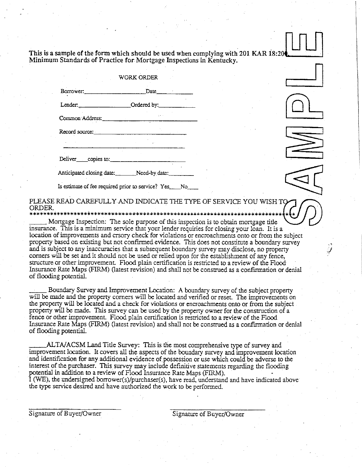
Section 2. Work Order Required.
(1) Prior to conducting a mortgage inspection, a professional land surveyor shall obtain a
work order:
(a) Stating that the borrower or purchaser has been advised of the:
1. Types of services available; and
2. Scope of each type of service; and
(b) That has been signed by the borrower or purchaser.
(2) If the work order requires a flood plain certification, statements regarding the flood
plain shall contain the source or basis of the statements by reference to:
(a) Flood plain maps, by map identification number and date; and
(b) Any levels run by the surveyor to verify the elevation of the property.
(3) A work order shall include the following, the:
(a) Name of the borrower;
(b) Date the work was ordered;
(c) Name of the person ordering the work;
(d) Address or location of the parcel;
17
(e) Record source of the parcel;
(f) Anticipated closing date;
(g) Required delivery date; and
(h) Statements in subsection (4) of this section.
(4) The work order shall include the following statements:
(a) Mortgage inspection. The sole purpose of this inspection is to obtain mortgage
title insurance. This is the minimum service that your lender requires for closing
your loan. It is a location of improvements and cursory check for violations or
encroachments onto or from the subject property based on existing but not
confirmed evidence. This does not constitute a boundary survey and is subject to
any inaccuracies that a subsequent boundary survey may disclose; no property
corners will be set; and, it should not be used or relied upon for the establishment
of any fence, structure or other improvement. Flood plain certification is restricted
to a review of the Flood Insurance Rate Maps (FIRM) (latest revision), and shall
not be construed as a confirmation or denial of flooding potential.
(b) Boundary survey and improvement location. A boundary survey of the subject
property will be made and the property corners will be located and verified or reset.
The improvements on the property will be located and a check for violations or
encroachments onto or from the subject property will be made. This survey may be
used by the property owner for the construction of a fence or other improvement.
Flood plain certification is restricted to a review of the Flood Insurance Rate Maps
(FIRM) (latest revision), and shall not be construed as a confirmation or denial of
flooding potential.
(c) ALTA/ACSM land title survey. This is the most comprehensive type of survey
and improvement location. It covers all the aspects of the boundary survey and
improvement location and identification for any additional evidence of possession
or use which could be adverse to the interest of the purchaser. This survey may
include definitive statements regarding the flooding potential in addition to a review
of Flood Insurance Rate Maps (FIRM).
(5)
(a) A board "work order" sample form may be used.
(b) "Work Order (8-93)" is incorporated by reference.
(c) It may be inspected, copied, or obtained at Kentucky State Board of Licensure
for Professional Engineers and Land Surveyors, 160 Democrat Drive, Frankfort,
Kentucky 40601, 8 a.m. to 4:30 p.m., Monday through Friday.
18
Section 3. Recorded Documentation and Boundary Evidence.
(1) A professional land surveyor shall obtain recorded documentation pertaining to the
property boundary that is sufficient to demonstrate general knowledge of the given area
which at a minimum would be to obtain the subject deed and the adjoining deeds.
(2) Field crews shall be provided with current information necessary to determine property
dimensions in the field.
(3) Field crews shall conduct a diligent search for existing boundary evidence.
(4) The highest available order of monumentation shall be used.
(5) The boundary monumentation, or evidence used shall be shown on the drawing.
(6) Conflicting boundary information shall be:
(a) Clearly shown on the drawing; and
(b) Reported to the client and the buyer in writing.
Section 4. Field Procedures.
(1) A field crew shall be provided with current information necessary to determine the
property dimensions in the field.
(2) A diligent search for existing boundary evidence shall be made by a field crew.
(3) The highest order of monumentation and boundary evidence shall be used.
(4) Detailed notes shall be:
(a) Taken on all mortgage inspections; and
(b) Kept as part of the professional land surveyor's permanent record.
(5) If the field survey methods selected by the surveyor do not produce a level of certainty
sufficient to determine whether encroachments exist, the surveyor shall recommend a
boundary survey to the borrower or purchaser.
19
Section 5. Drafting of the Parcel.
(1) A drawing of a parcel that is inspected shall be used in support of the certificate of
mortgage inspection.
(2) The following items shall be identified on a drawing of a parcel that is inspected:
(a) Property lines shall be shown by:
1. Boundary dimensions and bearings from the deed; or
2. Boundary dimensions and bearings from a record plat; or
3. By actual field measurement.
(b) The method of determination or basis of property lines shall be clearly shown.
(c) Major improvement locations shall be shown:
1. With dimensions to the nearest property lines;
2. With a minimum of three (3) dimensions; and
3. In a manner sufficient to locate the major improvement.
(d) Location dimensions shall be shown:
1. By offsets perpendicular to straight property lines; or
2. By offsets radial to curved property lines.
(e) Major improvements shall include:
1. Residences;
2. Garages;
3. Outbuildings;
4. Barns;
5. Driveways;
6. Pools;
7. Porches; and
8. Patios.
(f) Apparent encroachments shall be:
1. Noted and described; and
2. Clearly shown.
(g) Means of access shall:
1. Be shown clearly and graphically; and
2. Include shared access and shared driveways.
(h) Platted and apparent easements shall be clearly identified.
(i) The source of record information for platted and apparent easements shall be
identified by:
1. Deed book and page of recording; or
2. Title company commitment, including the name of title company and
commitment number; and
3. For apparent easements for items such as power lines, the name of the
easement holder.
(j) Platted setback lines shall be shown graphically.
(k) Adjacent owner and record source shall be noted on the drawing.
20
1. Lot numbers may be used for adjacent properties located in recorded
subdivisions.
2. Conflicting boundary information shall be:
a. Clearly shown on the drawing; and
b. Reported to the client and the buyer in writing.
(l) If the address of the inspected parcel is:
1. Posted, it shall be shown; or
2. Not posted, a statement to that effect shall be included.
(m) A north arrow with the basis for the meridian shall be shown on the drawing.
(n) A graphic scale shall be shown on the drawing.
(o) All apparent encroachments shall be:
1. Noted and described on the drawing; and
2. Clearly shown on the drawing.
(p) A flood plain certification required by the work order shall reference:
1. Flood plain maps by map identification number and date; and
2. Levels run by the surveyor to verify the elevation of the inspected
property.
(q) The following caption shall appear prominently on the sketch:
MORTGAGE INSPECTION
This does not constitute a boundary survey
and is not a recordable document.
(r) If the certification and the drawing are on separate pieces of paper, this shall be
stated in the report as: (Example: page 1 of 2, page 2 of 2).
(s) The sign and seal of the surveyor and the date of the mortgage inspection.
Section 6. Certification.
(1) A mortgage inspection shall not contain the word "survey" in any part of the
certification.
(2) The mortgage inspection certification shall contain:
(a) The name, address and telephone number of the professional land surveyor
responsible for the mortgage inspection;
(b) The name of the party who ordered the work;
(c) A statement that the mortgage inspection was conducted either by the
professional land surveyor or under the surveyor's direct supervision;
(d) The date the inspection was made;
(e) The record source of the property;
(f) A statement that:
21
1. The accompanying sketch or drawing is a true representation of the
conditions found at the time of the inspection;
2. The mortgage inspection is prepared for mortgage title insurance
purposes only;
3. The document does not constitute a boundary survey;
4. The mortgage inspection is subject to any inaccuracies that a
subsequent boundary survey may disclose;
5. No property corners were set;
6. The information shown on the sketch should not be used to establish any
fence, structure or other improvement;
7. The linear or angular values shown on the drawing are based on record
information, and have not been verified unless so noted.
(3) A mortgage inspection by a professional land surveyor shall:
(a) Be signed by the surveyor;
(b) Bear his seal; and
(c) Note the date of the mortgage inspection.
(20 Ky.R. 871; Am. 1579; eff. 12-6-93.)

STANDARDS OF PRACTICE
FOR BOUNDARY SURVEYS
DESCRIPTION CHECKLIST
201 KAR 18:150 Effective 11-9-2010
PLS Name PLS License No.
Project ID Review Date
1. Location caption: a. General location
b. Specific location
c. Reference to parent tract
2. Direction and length of each line: a. Bearings in degrees, minutes & seconds
b. Distances to the hundredths of a foot
c. Curves with sufficient data
d. Description of prominent terrain feature
3. Monument notations: a. Set or found
4. Identification of tree monuments: a. Breast height diameter
b. Species
c. Method of marking
d. Notation – new or record
5. Complete description of each set monument:
a. Length
b. Diameter
c. Type of material
d. Identifying cap or identifier

6. Complete description of each found monument:
a. Dimensions
b. Type of material
c. Identification cap or identifier
7. Cemetery location description:
8. Record source: a. Of the land surveyed
b. Adjoiner names
c. Adjoiner record sources
9. Calculated area: a. To the nearest hundredth of an acre
10. Land Surveyor information: a. Name
b. Certification date
c. License number
d. Seal/stamp
e. Firm name, if any
11. Completion date of the boundary survey:

STANDARDS OF PRACTICE
FOR BOUNDARY SURVEYS
PLAT OF SURVEY CHECKLIST
201 KAR 18:150 Effective 11-9-2010
PLS Name PLS License No.
Project ID Review Date
1. Direction and Length of each line: a. Bearings in degrees, minutes and seconds
b. Distances to the hundredths of a foot
c. Curves with sufficient data
d. Depiction of prominent terrain feature
2. Calculated area to the hundredths of an acre:
3. Monument notations: a. Set or found
4. Identification of tree monuments: a. Breast height diameter
b. Species
c. Method of marking
d. Notation – new or record
5. Complete description of each set monument:
a. Length
b. Diameter
c. Type of material
d. Identifying cap or identifier

6. Complete description of each found monument:
a. Dimensions
b. Type of material
c. Identifying cap or identifier
7. Reference of at least one corner to:
a. Corner of the parent tract
b. Durable physical feature
c. Primary Control network
8. Each Road: a. Name
b. Record source
9. Each Adjoiner: a. Names
b. Record source
10. Each Adjoining Subdivision: a. Name
b. Record source
11. Apparent encroachments discovered:
12. Reference Meridian basis: a. True
b. Grid
c. Record, including the source
d. State plane
e. Magnetic, including date and location
13. Vicinity map with sufficient detail to locate the parcel:
14. Statement, as appropriate, of the: a. Unadjusted error of closure
b. Relative positional accuracy

15. Statement identifying the class of the survey (rural or urban):
16. Statement as to whether the directions and distances are based on an adjusted traverse:
17. Cemetery Location
18. Dated signature and seal of professional land surveyor:
19. Scale a. Written
b. Graphic
20. Title Block containing: a. Name and address of the client
b. Name and address of property owner
c. Title of survey
d. Statement that the survey complies with 201 KAR
18:150
e. Name and business address of surveyor
f. Name and address of firm
21. Place conspicuously on the plat a. Record source of tract surveyed
b. Location or address of tract