
Oldham County Comprehensive Zoning Ordinance
i
TABLE OF CONTENTS
DIVISION 010 GENERAL PROVISIONS ............................................................................................................1
Sec. 010-010 General Provisions: Intent ...........................................................................................................1
Sec. 010-020 Title .................................................................................................................................................1
Sec. 010-030 Legislative Authority .....................................................................................................................1
Sec. 010-040 Roles and Authority ......................................................................................................................1
Sec. 010-050 Application of Regulations............................................................................................................4
Sec. 010-060 Establishment of Districts and General Regulations ..................................................................4
Sec. 010-070 Boundaries of Districts ..................................................................................................................5
Sec. 010-080 Designation of Official Zoning Map ............................................................................................5
Sec. 010-090 Replacement of Official Zoning Map...........................................................................................6
Sec. 010-100 Conflict with Other Resolutions and Private Deeds ...................................................................6
Sec. 010-110 Calculations ....................................................................................................................................6
Sec. 010-120 Severability .....................................................................................................................................6
Sec. 010-130 Effective Date .................................................................................................................................7
Sec. 010-140 Joint Planning Units ......................................................................................................................7
DIVISION 020 AG-1 AGRICULTURAL/RESIDENTIAL DISTRICT .............................................................8
Sec. 020-010 AG-1 Agricultural/Residential District: Intent ..........................................................................8
Sec. 020-020 AG-1 Agricultural/Residential District: Development Regulations .........................................8
Sec. 020-030 AG-1 Agricultural/Residential District: Permitted Uses ..........................................................9
Sec. 020-040 AG-1 Agricultural/Residential District: Conditional Uses .......................................................9
DIVISION 025 AG-2 AGRICULTURAL BUSINESS DISTRICT ................................................................... 10
Sec. 025-010 AG-2 Agricultural/Residential District: Intent ....................................................................... 10
Sec. 025-020 AG-2 Agricultural/Residential District: Development Regulations ...................................... 10
Sec. 020-030 AG-2 Agricultural/Residential District: Permitted Uses ....................................................... 11
Sec. 020-040 AG-1 Agricultural/Residential District: Conditional Uses .................................................... 11
DIVISION 030 CO-1 CONSERVATION/RESIDENTIAL DISTRICT ........................................................... 12
Sec. 030-010 CO-1 Conservation/Residential District: Intent ..................................................................... 12
Sec. 030-020 CO-1 Agricultural/Residential District: Development Regulations ...................................... 12
Sec. 030-030 CO-1 Agricultural/Residential District: Permitted Uses ....................................................... 13
Sec. 030-040 CO-1 Agricultural/Residential District: Conditional Uses .................................................... 13
DIVISION 040 R-1A RESIDENTIAL DISTRICT ............................................................................................. 14
Sec. 040-010 R-1A Residential District: Intent ............................................................................................. 14
Sec. 040-020 R-1A Residential District: Development Regulations ............................................................ 14

Oldham County Comprehensive Zoning Ordinance
ii
Sec. 040-030 R-1A Residential District: Permitted Uses .............................................................................. 15
Sec. 040-040 R-1A Residential District: Conditional Uses ........................................................................... 15
DIVISION 050 R-1 RESIDENTIAL DISTRICT ............................................................................................... 16
Sec. 050-010 R-1 Residential District: Intent ................................................................................................ 16
Sec. 050-020 R-1 Residential District: Development Regulations ............................................................... 16
Sec. 050-030 R-1 Residential District: Permitted Uses ................................................................................ 17
Sec. 050-040 R-1 Residential District: Conditional Uses .............................................................................. 17
DIVISION 060 R-2 RESIDENTIAL DISTRICT ............................................................................................... 18
Sec. 060-010 R-2 Residential District: Intent ................................................................................................ 18
Sec. 060-020 R-2 Residential District: Development Regulations ............................................................... 18
Sec. 060-030 R-2 Residential District: Permitted Uses ................................................................................ 19
Sec. 060-040 R-2 Residential District: Conditional Uses .............................................................................. 19
DIVISION 070 R-2A RESIDENTIAL DISTRICT ............................................................................................. 20
Sec. 070-010 R-2A Residential District: Intent ............................................................................................. 20
Sec. 070-020 R-2A Residential District: Development Regulations ............................................................ 20
Sec. 070-030 R-2A Residential District: Permitted Uses ............................................................................. 21
Sec. 070-040 R-2A Residential District: Conditional Uses ........................................................................... 21
DIVISION 080 R-3 RESIDENTIAL DISTRICT ............................................................................................... 22
Sec. 080-010 R-3 Residential District: Intent ................................................................................................ 22
Sec. 080-020 R-3 Residential District: Development Regulations ............................................................... 22
Sec. 080-030 R-3 Residential District: Permitted Uses ................................................................................ 23
Sec. 080-040 R-3 Residential District: Conditional Uses .............................................................................. 23
DIVISION 090 R-4 RESIDENTIAL DISTRICT ............................................................................................... 24
Sec. 090-010 R-4 Residential District: Intent ................................................................................................ 24
Sec. 090-020 R-4 Residential District: Development Regulations ............................................................... 24
Sec. 090-030 R-4 Residential District: Permitted Uses ................................................................................ 25
Sec. 090-040 R-4 Residential District: Conditional Uses .............................................................................. 25
DIVISION 100 R-4A RESIDENTIAL DISTRICT ............................................................................................. 26
Sec. 100-010 R-4A Residential District: Intent ............................................................................................. 26
Sec. 100-020 R-4A Residential District: Development Regulations ............................................................ 26
Sec. 100-030 R-4A Residential District: Permitted Uses ............................................................................. 27
Sec. 100-040 R-4A Residential District: Conditional Uses ........................................................................... 27
DIVISION 110 T MANUFACTURED HOME DISTRICT .............................................................................. 28
Sec. 110-010 T Manufactured Home District: Intent ................................................................................... 28

Oldham County Comprehensive Zoning Ordinance
iii
Sec. 110-020, A. T Manufactured Home District: Development Regulations for Manufactured Homes 28
Sec. 110-020, B. T Manufactured Home District: Development Regulations-NonManufactured Homes29
Sec. 110-030 T Manufactured Home District: Permitted Uses ................................................................... 30
Sec. 110-040 T Manufactured Home District: Conditional Uses ................................................................ 30
DIVISION 120 O-1 OFFICE DISTRICT ............................................................................................................ 31
Sec. 120-010 O-1 Office District: Intent ......................................................................................................... 31
Sec. 120-020 O-1 Office District: Development Regulations ....................................................................... 31
Sec. 120-030 O-1 Office District: Permitted Uses .......................................................................... 32
Sec. 120-040 O-1 Office District: Conditional Uses ............................................................................. 32
DIVISION 130 O-2 OFFICE DISTRICT ............................................................................................................ 33
Sec. 130-010 O-2 Office District: Intent ......................................................................................................... 33
Sec. 130-020 O-2 Office District: Development Regulations ....................................................................... 33
Sec. 130-030 O-2 Office District: Permitted Uses ................................................................................... 34
Sec. 130-040 O-2 Office District: Conditional Uses ................................................................................... 34
DIVISION 140 C-N COMMERCIAL NEIGHBORHOOD DISTRICT ......................................................... 35
Sec. 140-010 Commercial Neighborhood District: Intent ............................................................................ 35
Sec. 140-020 C-N Commercial Neighborhood District: Development Regulations ................................... 35
Sec. 140-030 C-N Commercial Neighborhood District: Permitted Uses..................................................... 36
Sec. 140-040 C-N Commercial Neighborhood: Conditional Uses ............................................................... 36
DIVISION 150 C-1 LOCAL BUSINESS DISTRICT ........................................................................................ 37
Sec. 150-010 C-1 Local Business District: Intent .......................................................................................... 37
Sec. 150-020 C-1 Local Business District: Development Regulations ......................................................... 37
Sec. 150-030 C-1 Local Business District: Permitted Uses ........................................................................... 38
Sec. 150-040 C-1 Local Business District: Conditional Uses ........................................................................ 38
DIVISION 160 C-2 COMMUNITY BUSINESS DISTRICT ............................................................................ 39
Sec. 160-010 C-2 Community Business District: Intent ............................................................................... 39
Sec. 160-020 C-2 Community Business District: Development Regulations .............................................. 39
Sec. 160-030 C-2 Community Business District: Permitted Uses ................................................................ 40
Sec. 160-040 C-2 Community Business District: Conditional Uses ............................................................. 40
DIVISION 170 C-3 GENERAL BUSINESS DISTRICT ................................................................................... 41
Sec. 170-010 C-3 General Business District: Intent ...................................................................................... 41
Sec. 170-020 C-3 General Business District: Development Regulations ..................................................... 41
Sec. 170-030 C-3 General Business District: Permitted Uses ...................................................................... 42
Sec. 170-040 General Business District: Conditional Uses........................................................................... 42

Oldham County Comprehensive Zoning Ordinance
iv
DIVISION 180 C-4 HIGHWAY SERVICE DISTRICT .................................................................................... 44
Sec. 180-010 C-4 Highway Service District: Intent ...................................................................................... 44
Sec. 180-020 C-4 Highway Service District: Development Regulations ..................................................... 44
Sec. 180-030 C-4 Highway Service District: Permitted Uses ....................................................................... 45
Sec. 180-040 C-4 Highway Service District: Conditional Uses .................................................................... 45
DIVISION 190 I-1 LIGHT INDUSTRIAL DISTRICT ..................................................................................... 47
Sec. 190-010 I-1 Light Industrial District: Intent ......................................................................................... 47
Sec. 190-020 I-1 Light Industrial District: Development Regulations ........................................................ 47
Sec. 190-030 I-1 Light Industrial District: Permitted Uses .................................................................... 48
Sec. 190-040 I-1 Light Industrial District: Conditional Uses ....................................................................... 48
DIVISION 200 I-2 HEAVY INDUSTRIAL DISTRICT .................................................................................... 49
Sec. 200-010 I-2 Heavy Industrial District: Intent ........................................................................................ 49
Sec. 200-020 I-2 Heavy Industrial District: Development Regulations ...................................................... 49
Sec. 200-030 I-2 Heavy Industrial District: Permitted Uses ........................................................................ 50
Sec. 200-040 I-2 Heavy Industrial District: Conditional Uses ..................................................................... 50
DIVISION 210 IPD INDUSTRIAL PARK DISTRICT ..................................................................................... 51
Sec. 210-010 IPD Industrial Park District: Intent ........................................................................................ 51
Sec. 210-020 IPD Industrial Park District: Development Regulations ....................................................... 51
Sec 210-030 IPD Industrial Park District: Permissible Encroachments into Required Yards ................ 51
Sec. 210-040 IPD Industrial Park District: Permitted Uses ......................................................................... 52
Sec. 210-050 IPD Industrial Park District: Conditional Uses ...................................................................... 53
Sec. 210-060 Parking Area Standards ............................................................................................................ 53
Sec. 210-070 Outdoor Storage ......................................................................................................................... 54
Sec. 210-080 Aesthetic Standards .................................................................................................................... 54
Sec. 210-090 Public Street Standards ............................................................................................................. 56
Sec. 210-100 Driveway Entrances ................................................................................................................... 56
Sec. 210-110 Utilities ......................................................................................................................................... 56
DIVISION 220 SWF-1 SOLID WASTE FACILITIES DISTRICT ................................................................. 57
Sec. 220-010 SWF-1 Solid Waste Facilities District: Intent ......................................................................... 57
Sec. 220-020 SWF-1 Solid Waste Facilities District: Development Regulations ........................................ 57
Sec. 220-030 Special Setback Requirements .................................................................................................. 57
Sec. 220-040 SWF-1 Solid Waste Facilities: Permitted Uses ....................................................................... 58
Sec. 220-050 Access to Public Streets .............................................................................................................. 59
Sec. 220-060 Driving Facilities ......................................................................................................................... 59

Oldham County Comprehensive Zoning Ordinance
v
Sec. 220-070 Buffering ...................................................................................................................................... 60
DIVISION 230 PUD PLANNED UNIT DEVELOPMENT DISTRICT .......................................................... 61
Sec. 230-010 Planned Unit Development District: Intent.............................................................................. 61
Sec. 230-020 General Standards and Requirements ..................................................................................... 61
Sec. 230-030 Uses Permitted and Prohibited .................................................................................................. 63
Sec. 230-040 Density, Intensity and Dimensional Standards ........................................................................ 64
Sec. 230-050 Phased Development .................................................................................................................. 64
Sec. 230-060 Procedures ................................................................................................................................... 65
Sec. 230-070 Conditions of Approval in Master Plan and Development Plan ............................................ 68
Sec. 230-080 Amendments to an Approved Master Plan or Development Plan ......................................... 68
Sec. 230-090 Master Plan Requirements ........................................................................................................ 69
Sec. 230-100 Development Plan ....................................................................................................................... 72
Sec. 230-110 Site Plan Requirements .............................................................................................................. 74
Sec. 230-120 Maintenance of (Common) Open Space ................................................................................... 77
Sec. 230-130 Bonds ........................................................................................................................................... 77
Sec. 230-140 Failure to Proceed, Complete or Comply ................................................................................. 77
Sec. 230-150 Certificate of Completion, Future Development ..................................................................... 78
DIVISION 235 PRD PLANNED RESIDENTIAL DEVELOPMENT DISTRICT ......................................... 79
Sec. 235-010 Planned Residential Development District: Intent .................................................................. 79
Sec. 235-020 Permitted Uses ............................................................................................................................ 80
Sec. 235-030 Conditional Uses ......................................................................................................................... 80
Sec. 235-040 Property Development Regulations .......................................................................................... 80
Sec. 235-050 Special Requirements ................................................................................................................. 80
DIVISION 240 LAGRANGE HISTORIC DISTRICTS .................................................................................... 82
DIVISION 245 HIGHWAY 53 CORRIDOR OVERLAY DISTRICT (CITY OF LAGRANGE) ................ 83
Sec. 245-010 Highway 53 Corridor Overlay District: Intent ....................................................................... 83
Sec. 245-020 Highway 53 Corridor Overlay District: Development Regulations ...................................... 83
Sec. 245-040 Highway 53 Corridor Overlay District: Permitted Uses........................................................ 83
Sec. 245-050 Highway 53 Corridor Overlay District: Conditional Uses .................................................... 83
Sec. 245-060 Site Description and Purpose ..................................................................................................... 84
Sec. 245-70 Exterior Lighting ........................................................................................................................... 84
Sec. 245-80 Parking ........................................................................................................................................... 85
Sec. 245-90 Landscape & Buffering ................................................................................................................. 86
Sec. 245-100 Building Design ............................................................................................................................ 89

Oldham County Comprehensive Zoning Ordinance
vi
Sec. 245-110 Pedestrian Access......................................................................................................................... 89
Sec. 245-120 Implementation ............................................................................................................................ 90
DIVISION 250 SPECIAL PROVISIONS ........................................................................................................... 91
Sec. 250-010 Special Provisions: Purpose ...................................................................................................... 91
Sec. 250-020 Applicability ................................................................................................................................ 91
Sec. 250-030 Accessory Uses and Structures (without dwelling units) ........................................................ 91
Sec. 250-040 Accessory Dwelling Units ........................................................................................................... 92
Sec. 250-045 Accessory Service and Retail Uses ............................................................................................ 94
Sec. 250-050 Short Term Rental Propery ....................................................................................................... 95
Sec. 250-055 Adjacent to Residential Standards ............................................................................................ 98
Sec. 250-060 Adult Entertainment .................................................................................................................. 98
Sec. 250-070 Attached Single-Family Structures ......................................................................................... 102
Sec. 250-075 Residential Care Facilities ....................................................................................................... 103
Sec. 250-080 Qualified Manufactured Homes .............................................................................................. 103
Sec. 250-090 Fences and Walls ...................................................................................................................... 104
Sec. 250-100 Fuel Sales and Vehicle-Repair ................................................................................................. 104
Sec 250-110 Land Use for Agricultural Purposes ........................................................................................ 104
Sec. 250-130 Manufactured Homes Supporting Agriculture Uses ............................................................. 104
Sec. 250-140 Outdoor Sales, Storage, or Display ......................................................................................... 105
Sec. 250-150 Public Utility Buildings and Facilities (not including utility pedestals & junction boxes) 106
Sec. 250-160 Refuse Disposal Containers for Uses Other than Single-Family Residential ..................... 106
Sec. 250-170 Swimming Pools, Hot Tubs and Hydro Spas ........................................................................ 106
Sec. 250-180 Temporary Uses and Events .................................................................................................... 107
Sec. 250-190 Tennis Courts ............................................................................................................................ 107
Sec. 250-200 Scenic Corridors ....................................................................................................................... 108
Section 250-300 Distilleries, Craft Distilleries Breweries, Microbreweries ................................................ 112
Section 250-310 Brewpubs .............................................................................................................................. 113
Section 250-320 Barrel Warehouses .............................................................................................................. 113
DIVISION 260 CONDITIONAL USE STANDARDS ..................................................................................... 114
Sec. 260-010 Conditional Use Standards: Purpose ..................................................................................... 114
Sec. 260-020 General Provisions ................................................................................................................... 114
Sec. 260-030 Accessory Structures ................................................................................................................ 115
Sec. 260-035 Agritourism Buildings .............................................................................................................. 115
Sec. 260-040 Airports ..................................................................................................................................... 117

Oldham County Comprehensive Zoning Ordinance
vii
Sec. 260-050 All Terrain Vehicle (ATV) Courses ........................................................................................ 117
Sec. 260-060 Amusement Parks, Aviaries, Zoos, and Circus and Carnival Grounds .............................. 117
Sec. 260-070 Asphalt Processing and Concrete Batch Plants ..................................................................... 117
Sec. 260-075 Auto Auctions ........................................................................................................................... 118
Sec. 260-080 Cemeteries, Mausoleums and Crematories ............................................................................ 118
Sec. 260-090 Commercial Composting (Reserved) ...................................................................................... 118
Sec. 260-100 Commercial Rifle, Pistol, Skeet, Trap and Sporting Ranges ................................................ 118
Sec. 260-120 Concentrated Animal Feeding Operations............................................................................. 118
Sec. 260-130 Contractor’s Equipment Storage (Reserved) ......................................................................... 119
Sec. 260-140 Day Care Facilities ................................................................................................................... 119
Sec. 260-150 Extraction, Development of Oil, Gas and other Hydrocarbon Substances ......................... 119
Sec. 260-160 Extraction, Rock Quarries, Mineral, and Earth Products, not including extraction of soil
........................................................................................................................................................................... 120
Sec. 260-170 Extraction and Development of Other Natural Resources ................................................... 120
Sec. 260-180 Extraction of Soil, including Borrow Pits ............................................................................... 120
Sec. 260-190 Fertilizer Producing Plant, Incineration or Reduction Products ......................................... 123
Sec. 260-200 Freight Terminals/Similar Enterprises (Reserved) ............................................................... 123
Sec. 260-210 Golf Driving Ranges ................................................................................................................. 123
Sec. 260-220 Grain/Feed Storage/Sales (Reserved) ..................................................................................... 123
Sec. 260-230 Home Occupations.................................................................................................................... 124
Sec. 260-240 Hospitals and Similar Uses ...................................................................................................... 126
Sec. 260-250 Lakes, Commercial ................................................................................................................... 126
Sec. 260-260 Land-Farming Facility for Solid Waste.................................................................................. 126
Sec. 260-270 Less Than One Acre Construction Demolition Debris Landfill (CDDL) ............................ 126
Sec. 260-280 Manufactured Homes ............................................................................................................... 128
Sec. 260-290 Marinas and Boat Rental ......................................................................................................... 128
Sec. 260-300 Nursing Homes (Reserved) ...................................................................................................... 128
Sec. 260-310 Office Warehouses (Reserved) ................................................................................................ 128
Sec. 260-320 Private Utility Buildings/Facilities (Reserved) ....................................................................... 129
Sec. 260-330 Public and Governmental Buildings and Facilities Including Offices, Training Armories,
Storage, Maintenance, and Repair ................................................................................................................. 129
Sec. 260-340 Public or Private Clubs Including Swimming, Tennis or Other Recreation ...................... 129
Sec. 260-350 Race Tracks ............................................................................................................................... 129
Sec. 260-360 Recreational Camping Areas, Public and Private ................................................................. 129
Sec. 260-370 Riding Academies/Stables (Reserved) .................................................................................... 130

Oldham County Comprehensive Zoning Ordinance
viii
Sec. 260-380 Salvage yards, or Similar Establishments, Including Vehicle Wrecking, Metal, Paper,
Glass, or Waste ................................................................................................................................................ 130
Sec. 260-390 Sanitary Land Fills ................................................................................................................... 130
Sec. 260-400 Self Storage Facilities ............................................................................................................... 131
Sec. 260-410 Slaughter Houses, Rendering Plants or Similar Uses ........................................................... 131
Sec. 260-420 Solid Waste Incinerators (Reserved) ...................................................................................... 131
Sec. 260-430 Sports Facilities ......................................................................................................................... 131
Sec. 260-440 Veterinary Hospitals and Kennels .......................................................................................... 131
Sec. 260-450 Wastewater Treatment Plant .................................................................................................. 132
DIVISION 270 CAPACITY STANDARDS ...................................................................................................... 133
Sec. 270-010 Establishment of Capacity Standards .................................................................................... 133
Sec. 270-020 Exemptions from Capacity Standards Requirements ........................................................... 133
Sec. 270-030 Responsibility for Capacity Standards Management System .............................................. 133
Sec. 270-040 Road Capacity Standards ........................................................................................................ 133
Sec. 270-050 School Capacity Standards ...................................................................................................... 138
Sec. 270-060 Fire Protection Standards ........................................................................................................ 139
Sec. 270-070 Wastewater Treatment Facility Standards ............................................................................ 141
Sec. 270-080 Postal Capacity Standards ....................................................................................................... 143
DIVISION 280 OFF-STREET PARKING AND LOADING REGULATIONS ........................................... 144
Sec. 280-010 Off-Street Parking and Loading Regulations: Purpose ....................................................... 144
Sec. 280-020 Relationship to the Comprehensive Plan................................................................................ 144
Sec. 280-030 Applicability .............................................................................................................................. 144
Sec. 280-040 Parking Requirement/Allowances Calculations .................................................................... 144
Sec. 280-050 Industrial and Manufacturing................................................................................................. 145
Sec. 280-060 Institutional ............................................................................................................................... 145
Sec. 280-070 Office Use .................................................................................................................................. 147
Sec. 280-080 Non-Retail Commercial/Recreational..................................................................................... 148
Sec. 280-090 Other/Miscellaneous ................................................................................................................. 151
Sec. 280-100 Residential Uses ........................................................................................................................ 151
Sec. 280-110 Retail .......................................................................................................................................... 152
Sec. 280-120 Location of Off-Street Parking on a Lot ................................................................................ 154
Sec. 280-130 Off-Site Parking ........................................................................................................................ 154
Sec. 280-140 Shared Parking ......................................................................................................................... 155
Sec. 280-150 Parking Lot Layout and Design .............................................................................................. 155
Sec. 280-160 Accessible Parking for Physically Handicapped Persons ..................................................... 156

Oldham County Comprehensive Zoning Ordinance
ix
Sec. 280-170 Drive-In Facilities and Queue Space Requirements .............................................................. 156
Sec. 280-180 Off-Street Loading ................................................................................................................... 156
Sec. 280-190 Waivers ...................................................................................................................................... 157
DIVISION 290 SIGN REGULATIONS ............................................................................................................ 158
Sec. 290-010 Purpose ....................................................................................................................................... 158
Sec. 290-020 Applicability ............................................................................................................................... 158
Sec. 290-030 Sign Definitions .......................................................................................................................... 158
Sec. 290-040 Procedure ................................................................................................................................... 164
Sec. 290-045 Sign Permits ............................................................................................................................... 164
Sec. 290-050 Sign Requirements/Allowances Calculations .......................................................................... 164
Sec. 290-060 Exempt Sign Standards ............................................................................................................. 165
Sec. 290-070 Signs Prohibited ......................................................................................................................... 166
Sec. 290-080 Sign Lighting .............................................................................................................................. 167
Sec. 290-090 Electronic Signs ....................................................................................................................... 167
Sec. 290-100 Permanent Signage .................................................................................................................. 168
Sec. 290-120 Temporary Signage ................................................................................................................... 177
Sec. 290-130 Areas of Special Character ..................................................................................................... 178
Sec. 290-140 Programs for Signs .................................................................................................................. 178
Sec. 290-150 Signs along Scenic Corridors .................................................................................................. 178
Sec. 290-160 Nonconforming Signs .............................................................................................................. 179
Sec. 290-170 Variances .................................................................................................................................. 180
Sec. 290-180 Severability Clause .................................................................................................................. 180
DIVISION 300 LANDSCAPING REGULATIONS ......................................................................................... 181
Sec. 300-010 Landscaping Regulations: Purpose ........................................................................................ 181
Sec. 300-020 Relationship to the Comprehensive Plan................................................................................ 181
Sec. 300-030 Applicability .............................................................................................................................. 181
Sec. 300-040 General Standards .................................................................................................................... 182
Sec. 300-050 Landscape Buffer Areas (LBA) and Plantings ...................................................................... 185
Sec. 300-060 Interior Landscaping Areas (ILA) for Vehicular Use Areas ................................................ 188
Sec. 300-070 Tree Preservation ...................................................................................................................... 189
Sec. 300-080 Tree Protection during Construction and Maintenance ........................................................ 190
Sec. 300-090 Screening Requirement for Service Structures ...................................................................... 190
Sec. 300-100 Landscaping Plan Submission and Approval ......................................................................... 191
Sec. 300-110 Alternative Compliance, Permits and Waivers ...................................................................... 192

Oldham County Comprehensive Zoning Ordinance
x
Sec. 300-120 Code Enforcement and Fines ................................................................................................... 192
Sec. 300-130 Metro Louisville Approved/Prohibited Tree Species Planting List Updated 2016 ............ 193
DIVISION 305 ALL NONCONFORMING USES AND STRUCTURES ..................................................... 222
Sec. 305-010 Continuation and Maintenance ............................................................................................... 222
Sec. 305-020 Expansion of Nonconforming Use ........................................................................................... 222
Sec. 305-030 Restoration of a Damaged Structure or Building .................................................................. 222
Sec. 305-040 Abandonment of Nonconforming Use .................................................................................... 222
Sec. 305-050 Substituting Nonconforming Use ............................................................................................ 222
Sec. 305-060 Regulating Manufactured Homes and Manufactured Home Parks .................................... 222
Sec. 305-070 Additions to Nonconforming Structures and Buildings ........................................................ 223
DIVISION 310 LIGHTING REGULATIONS ................................................................................................. 224
Sec. 310-010 Purpose and Intent ................................................................................................................... 224
Sec. 310-020 Applicability .............................................................................................................................. 224
Sec. 310-030 Definitions ................................................................................................................................. 224
Sec. 310-040 General Requirements: ............................................................................................................ 225
Sec. 310-050 Exceptions ................................................................................................................................. 227
Sec. 310-060 Sign Lighting ............................................................................................................................. 227
Sec. 310-070 Prohibited Lighting: ................................................................................................................. 228
Sec. 310-080 Lighting Plan Requirements .................................................................................................... 228
Sec. 310-090 Inspections of Site, Building or Sign Lighting Installation ................................................... 230
Sec. 310-100 Nonconforming Uses ................................................................................................................ 230
Sec. 310-110 Permits and Waivers ................................................................................................................ 230
DIVISION 320 ACCESS MANAGEMENT REGULATIONS ....................................................................... 231
Sec. 320-010 Intent and Applicability ........................................................................................................... 231
Sec. 320-020 Relationship to the Comprehensive Plan................................................................................ 231
Sec. 320-030 Access Classification System and Standards.......................................................................... 231
Sec. 320-040 Corner Clearance ..................................................................................................................... 232
Sec. 320-060 Requirements for Unified Access and Circulation ................................................................ 234
Sec. 320-070 Driveway Location and Design ................................................................................................ 234
Sec. 320-080 Redevelopment .......................................................................................................................... 235
Sec. 320-090 Corridor Access Management Overlay Zones ....................................................................... 236
Sec. 320-100 Access to Homes and Subdivisions .......................................................................................... 236
DIVISION 330 EXCEPTIONS AND MODIFICATIONS .............................................................................. 237
Sec. 330-010 Height Requirements................................................................................................................ 237

Oldham County Comprehensive Zoning Ordinance
xi
Sec. 330-020 Yard Requirements ................................................................................................................... 237
Sec. 330-040 Sight Triangle ............................................................................................................................ 238
Sec. 330-050 Sell-Off Approval (Future Rights-of-Way Reservation) ........................................................ 239
Sec. 330-060 Water Supply and Sewage Disposal ......................................................................................... 239
DIVISION 340 ANTENNA TOWERS FOR TELECOMMUNICATION SERVICES OR PERSONAL
COMMUNICATIONS SERVICES ................................................................................................................... 240
Sec. 340-010 Planning Commission Review Required ................................................................................ 240
Sec. 340-020 Documentation .......................................................................................................................... 240
Sec. 340-030 Notice ......................................................................................................................................... 242
Sec. 340-040 Procedure .................................................................................................................................. 242
Sec. 340-050 Guarantee of Removal in Case of Abandonment .................................................................. 243
Sec. 340-060 Special Expert Consultants and Costs .................................................................................... 244
Sec. 340-070 Confidentiality .......................................................................................................................... 244
Sec. 340-080 Design Standards ...................................................................................................................... 244
DIVISION 350 BOARDS OF ADJUSTMENTS ............................................................................................... 247
Sec. 350-010 Authorization ............................................................................................................................ 247
Sec. 350-020 Meetings and Procedures ......................................................................................................... 247
Sec. 350-030 Appeals ...................................................................................................................................... 248
Sec. 350-040 Powers of Board of Adjustments ............................................................................................. 248
DIVISION 360 BUILDING PERMITS AND FEES ........................................................................................ 251
Sec. 360-010 Building Permits Required ...................................................................................................... 251
Sec. 360-020 Exceptions for which Building Permits are not Required .................................................... 251
Sec. 360-030 Building Permit Procedure ...................................................................................................... 251
Sec. 360-035 Agricultural Buildings.............................................................................................................. 251
Sec. 360-040 Construction Equipment.......................................................................................................... 251
DIVISION 370 ADMINISTRATION, ENFORCEMENT AND PENALTIES ............................................. 252
Sec. 370-010 Administration .......................................................................................................................... 252
Sec. 370-020 Code Enforcement .................................................................................................................... 252
Sec. 370-030 Compliance with Zoning Ordinance and Subdivision Regulations ..................................... 252
Sec. 370-040 Administration in Incorporated Areas ................................................................................... 252
Sec. 370-050 Real Estate Sell-Off .................................................................................................................. 253
DIVISION 380 ZONING MAP AMENDMENT PROCEDURES AND DEVELOPMENT PLAN
REQUIREMENTS .............................................................................................................................................. 254
Sec. 380-010 Application Process .................................................................................................................. 254
Sec. 380-020 Development Plan ..................................................................................................................... 255

Oldham County Comprehensive Zoning Ordinance
xii
Sec. 380-030 Zoning Map Amendment Process ........................................................................................... 258
Sec. 380-040 Implementation of Development Plan and Zoning Regulations............................................ 259
Sec. 380-050 Review of Planning Commission’s Action Regarding Development Plans .......................... 260
DIVISION 390 SITE PLAN REGULATIONS ................................................................................................. 262
Sec. 390-010 Applicability .............................................................................................................................. 262
Sec. 390-020 Specific Information Required ................................................................................................ 262
Sec. 390-030 Property Owners’ Signature and Responsibility for Accuracy ............................................ 264
Sec. 390-040 Site Plan Review Procedure ..................................................................................................... 264
Sec. 390-050 Extension of Site Plan Approval ............................................................................................. 266
DIVISION 400 COMMUNITY FACILITY REVIEW .................................................................................... 267
DIVISION 410 ENVIRONMENTAL PERFORMANCE STANDARDS ...................................................... 268
DIVISION 420 DEFINITIONS .......................................................................................................................... 269

Oldham County Comprehensive Zoning Ordinance
Division 010 General Provisions
1
DIVISION 010 GENERAL PROVISIONS
Sec. 010-010 General Provisions: Intent
The intent of these regulations is to promote the public health, safety, and the general welfare; to prevent
overcrowding of land and provide for planned and orderly growth; to protect land from premature or
unsuitable development; to avoid undue concentration of the population; to protect and guide development
of rural areas; to insure adequate provision for transportation, water supply, sewage disposal, schools,
parks, open space, natural areas and other public requirements; to encourage the most appropriate use of
land and structures throughout the county and its cities; to guide and accomplish a coordinated, adjusted,
and harmonious development of all areas of the county and its cities; and to aid in the implementation of
the Comprehensive Plan.
Sec. 010-020 Title
This ordinance-resolution is entitled “OLDHAM COUNTY COMPREHENSIVE ZONING
ORDINANCE” and may be referred to as the “Zoning Ordinance” for all of Oldham County, Kentucky.
The map herein referred to is identified by the title “Oldham County Zoning Map” and may be referred to
as the “Official Zoning Map”. The official copy of this map is on file with the Administrator of Oldham
County (“the Administrator”) in the office of the Oldham County Planning and Zoning Commission (“the
Commission”) in LaGrange, Kentucky.
Sec. 010-030 Legislative Authority
Kentucky Revised Statute (KRS) 100.201 gives legislative bodies and fiscal courts the authority to enact
permanent land use regulations, including zoning and growth management regulations.
Sec. 010-040 Roles and Authority
A. Planning & Zoning Administrator
1. This ordinance shall be administered and enforced by the Administrator. Unless specifically
stated to the contrary, the term “Administrator” shall include his or her designee.
2. The Administrator may be designated to issue building permits or certificates of occupancy, or
both, in accordance with the literal terms of the regulation, but may not have the power to
permit any construction, or to permit any use or any change of use which does not conform to
the literal terms of the zoning regulation.
B. Legislative Bodies of the Oldham County Planning Unit
1. Adopt, reject, or amend the Oldham County Comprehensive Plan, herein after referred to as
the “Comprehensive Plan”, or Zoning Ordinance.
2. Unless specifically stated to the contrary, the term “Commission” shall mean the Oldham
County Planning and Zoning Commission.

Oldham County Comprehensive Zoning Ordinance
Division 010 General Provisions
2
3. Adopt, reject, or amend proposals to amend or partially repeal the text of the Comprehensive
Plan, Zoning Ordinance, or Subdivision Regulations that has been submitted by the
Commission.
4. Adopt, reject, or amend proposals to amend the Official Zoning Map submitted by the
Commission.
5. Initiate amendments to the text of the Comprehensive Plan, Zoning Ordinance, or Subdivision
Regulations.
6. Initiate amendments to the Official Zoning Map.
7. All powers as permitted by Kentucky Revised Statutes.
C. Oldham County Planning and Zoning Commission
1. Submit recommendations to the members of the Oldham County Planning Unit including new
versions of and revisions to the Comprehensive Plan, Zoning Ordinance, Subdivision
Regulations, and Official Zoning Map.
2. Adopt and maintain legislatively approved Comprehensive Plan, Zoning Ordinance, and
Subdivision Regulations as authorized under Kentucky Revised Statutes.
3. Adopt and maintain rules and procedures for holding meetings, holding public hearings, and
administrating and enforcing the Comprehensive Plan, Zoning Ordinance, and Subdivision
Regulations.
4. Maintain complete records of all meetings, hearings, correspondences, and affairs of the
Commission.
5. Record and file bonds and contracts for development and land use functions.
6. Publish and make available to the public all plans, ordinances, and other related materials that
are the responsibility of the Commission to the public and development community.
7. Adopt and maintain a permitting process to certify official or approved documents.
8. Review, hear, and approve or deny plats or replats of subdivisions.
9. Review, hear, and approve or deny all petitions for conditional use permits based on the
provisions of this ordinance in the event that the applicant files for a conditional use permit
concurrently with a zoning map amendment request.
10. Review, hear, and approve or deny all petitions for variances from development standards
(such as height, width, length or location of structures) of this ordinance in the event that the
applicant files for a variance concurrently with a subdivision approval and zoning map
amendment requests.
11. Review, hear, and approve or deny site development plans and amendments to site
development plans.
12. Enforce regulations and procedures of the Comprehensive Plan, Zoning Ordinance, and
Subdivision Regulations to the extent of the local regulations, Ordinances, and Kentucky
Revised Statutes.
13. Establish advisory committees as necessary which may include elected officials, appointed
officials, and the general public.
14. Help seek funding assistance through grant programs as necessary.

Oldham County Comprehensive Zoning Ordinance
Division 010 General Provisions
3
15. All powers as permitted by Kentucky Revised Statues.
D. Board of Adjustments (Oldham County, LaGrange and Pewee Valley)
1. Hear and decide appeals where it is alleged by the applicant that there is error in any order,
requirement, permit, decision, determination, or refusal made by the Administrator in the
enforcement of any provision of this ordinance.
2. Review, hear, and approve or deny all applications for conditional use permits based on the
provisions of this ordinance and Kentucky Revised Statutes.
3. Revoke conditional use permits or variances for noncompliance with the condition thereof.
4. Review, hear, and approve or deny all applications for variances from development standards
(such as height, width, length, or location of structures) of this ordinance.
5. All powers as permitted by Kentucky Revised Statutes.
6. Unless specifically stated to the contrary, the term “Board of Adjustments” shall mean Board
of Adjustments and Appeals.
E. Oldham County Technical Review Committee (TRC)
1. Unless specifically stated to the contrary, the term “The Committee” shall mean the Oldham
County Technical Review Committee.
2. Review applications and make recommendations to appropriate approval authorities regarding
approval, denial, and (where applicable) conditions and safeguards to be place upon the
approval of applications required by this ordinance including, but not limited to, the following:
a. Plats or replats of major subdivisions
b. Conditional Uses
c. Official Zoning Map Amendments
d. Site Development Plans and amendments to Site Development Plans
e. Street closings and street name changes
f. Other applications referred by the Commission or Board of Adjustments for review and
resolution of technical issues
g. Other applications referred to the Committee by the Administrator
F. Code Enforcement Board
1. To adopt rules and regulations to govern its operations and the conduct of its hearings.
2. To conduct hearings to determine if there has been a violation of the Zoning Ordinance or
Subdivision Regulations.
3. To subpoena alleged violators, witnesses, and evidence to its hearings.
4. To make findings of fat and issue orders necessary to remedy any violation of the Zoning
Ordinance and/or Subdivision Regulations which the Code Enforcement Board is authorized
to enforce.

Oldham County Comprehensive Zoning Ordinance
Division 010 General Provisions
4
Sec. 010-050 Application of Regulations
Within the areas of all of Oldham County, Kentucky, no building or land shall hereafter be used and no
building or part thereof shall be erected, moved, or altered unless for a use expressly permitted by, and in
conformity with, the regulations for the districts in which it is located.
Sec. 010-060 Establishment of Districts and General Regulations
A. Official Zoning District
For the purpose of this ordinance, all of Oldham County, Kentucky is hereby designated on the
Official Zoning Maps as being in one of the following districts:
AG-1 Agricultural/Residential District
AG-2 Agricultural Business District
CO-1 Conservation/Residential District
R-1A Residential District
R-1 Residential District
R-2 Residential District
R-2A Residential District
R-3 Residential District
R-4A Residential District
R-4 Residential District
T Manufactured Home District
O-1 Office District
O-2 Office District
C-N Commercial Neighborhood District
C-1 Local Business District
C-2 Community Business District
C-3 General Business District
C-4 Highway Service District
I-1 Light Industrial District
I-2 Heavy Industrial District
IPD Industrial Park District
SWF-1 Solid Waste Facilities District
PRD Planned Residential Development District
PUD Planned Unit Development District
B. General Regulations
1. No land may be used except for a purpose permitted in the district in which it is located.
2. No building shall be erected, converted, enlarged, reconstructed, moved or structurally altered,
nor shall any building be used, designed, or intended to be used for any purpose except a use
permitted in the district in which the building is located.
3. No building shall be erected, converted, enlarged, reconstructed, or structurally altered to
exceed the height limit herein established for the district in which the building is located.

Oldham County Comprehensive Zoning Ordinance
Division 010 General Provisions
5
4. No building shall be erected, converted, enlarged, reconstructed, or structurally altered except
in conformity with the area regulations of the district in which the building is located.
5. The minimum yards and parking and open spaces, including minimum lot areas, required by
these regulations, for each and every building existing at the time of the passage of these
regulations or for any building hereafter erected, shall not be encroached upon nor considered
as required yard, parking space, or open space for any other building, nor shall any lot area be
reduced to less than the requirements of these regulations.
6. Every building hereafter erected or structurally altered shall be located on a lot, as herein
defined. In no case shall there be more than one principal structure on one lot in the zoning
districts of AG-1, CO-1, R-1, R-1A, and R-2, except as otherwise provided in these regulations.
Sec. 010-070 Boundaries of Districts
The boundaries of said districts are hereby established as shown upon the Official Zoning Map for all of
Oldham County, Kentucky. The Official Zoning Map is hereby made a part of this ordinance. The
Official Zoning Map and all notations, references, and other matters shown thereon shall be as much a
part of this ordinance as if they were fully described herein.
The following rules shall be used to interpret the exact location of the zoning district boundaries shown
on the Official Zoning Map:
1. When zoning district boundary lines are indicated as approximately following a street or railroad,
the centerline of the street or railroad right-of-way is the boundary of the district.
2. Where a zoning district boundary approximately follows a lot or property line that is not adjacent
to a street or railroad, that line is the boundary of the district.
3. Where zoning district boundary lines are indicated as approximately following a watercourse or
the shore of a body of water, the centerline of the watercourse or body of water is the boundary of
the district.
4. Where a zoning district boundary does not clearly follow any of the features mentioned above, its
exact location on the ground shall be determined by measurement according to the map scale or
by legal description of property in a previous zoning map amendment approved by the appropriate
legislative body.
5. In any case where the exact location of a boundary is not clear, the Administrator shall use these
rules to determine the exact location of a boundary. An appeal of the Administrator’s zoning
boundary determination may be filed with the appropriate Board of Adjustment and Appeals in
accordance with Section 350-030 of this ordinance.
Sec. 010-080 Designation of Official Zoning Map
If, in accordance with the provisions of this ordinance and KRS 100, changes are made in district
boundaries or other matter portrayed on the Official Zoning Map, such changes shall be entered on the
Official Zoning Map promptly after the amendment has been approved by the legislative body.

Oldham County Comprehensive Zoning Ordinance
Division 010 General Provisions
6
No changes of any nature shall be made in the Official Zoning Map or matter shown thereon except in
conformity with the procedures set forth in this ordinance. Any unauthorized change of whatever kind by
any person or persons shall be considered void, a violation of this ordinance, and punishable as provided
herein.
Regardless of the existence of purported copies of the Official Zoning Map, which may from time to time
be made or published, the Official Zoning Map, located in the Planning and Zoning Office, shall be the
final authority as to the current zoning status of the affected areas of Oldham County.
Sec. 010-090 Replacement of Official Zoning Map
In the event that an Official Zoning Map becomes damaged, destroyed, lost, or difficult to interpret
because of the nature or number of changes and additions, the legislative body may, by resolution, adopt
a new Official Zoning Map that shall supersede the prior Official Zoning Map. The new Official Zoning
Map may correct drafting or other errors or omissions in the prior Official Zoning Map, but no such
corrections shall have the effect of amending the original Official Zoning Map or any subsequent
amendment thereof.
Unless any prior Official Zoning Map has been lost or has been totally destroyed, the prior map, or any
significant parts thereof remaining, shall be preserved together with all available records pertaining to its
adoption or amendments.
Sec. 010-100 Conflict with Other Resolutions and Private Deeds
In the interpretation and application of the ordinance, the provisions contained herein shall be held to me
minimum requirements adopted for the promotion of public health, morals, safety, and general welfare.
Any existing resolution, ordinance, or part thereof that conflicts with the whole or any part of this
ordinance is hereby repealed.
In the case of any conflict between this ordinance, or part thereof, and the whole or part of any existing or
any future private covenants or deed, the more restrictive shall apply, but neither the zoning administrative
staff, zoning commission, nor various boards of adjustments shall have any standing or authority to
interpret or enforce the terms of any subdivision restrictions or covenants.
Sec. 010-110 Calculations
When the calculation of the number for any number for any requirements results in fractions, any fraction
less than one-half shall be disregarded and any fraction of one-half or more shall be rounded up to the next
whole number.
Sec. 010-120 Severability
If any article, section, clause, provision, or portion of this ordinance shall be held to be invalid or
unconstitutional by any court of competent jurisdiction, such holding shall not affect the full force and

Oldham County Comprehensive Zoning Ordinance
Division 010 General Provisions
7
effect of any other section, clause, provision, or portion for the ordinance which is not in itself invalid or
unconstitutional.
Sec. 010-130 Effective Date
The date that this ordinance shall come into effect is :
Oldham County Fiscal Court: September 17, 2019
LaGrange City Council: December 2, 2019
Pewee Valley City Council: December 2, 2019
Crestwood City Council: December 2, 2019
Sec. 010-140 Joint Planning Units
Oldham County Fiscal Court
LaGrange City Council
Pewee Valley City Council
Crestwood City Council
Oldham County Comprehensive Zoning Ordinance
Division 020 AG-1 Agricultural/Residential District
8
DIVISION 020 AG-1 AGRICULTURAL/RESIDENTIAL DISTRICT
Sec. 020-010 AG-1 Agricultural/Residential District: Intent
The AG-1 Agricultural/Residential District is intended to: (1) support and encourage agriculture for the
purpose of recognizing the cultural heritage of the community and the agricultural contribution to the
economic base; and (2) minimize urban-type development in rural areas until urban-type services and
utilities can be efficiently provided.
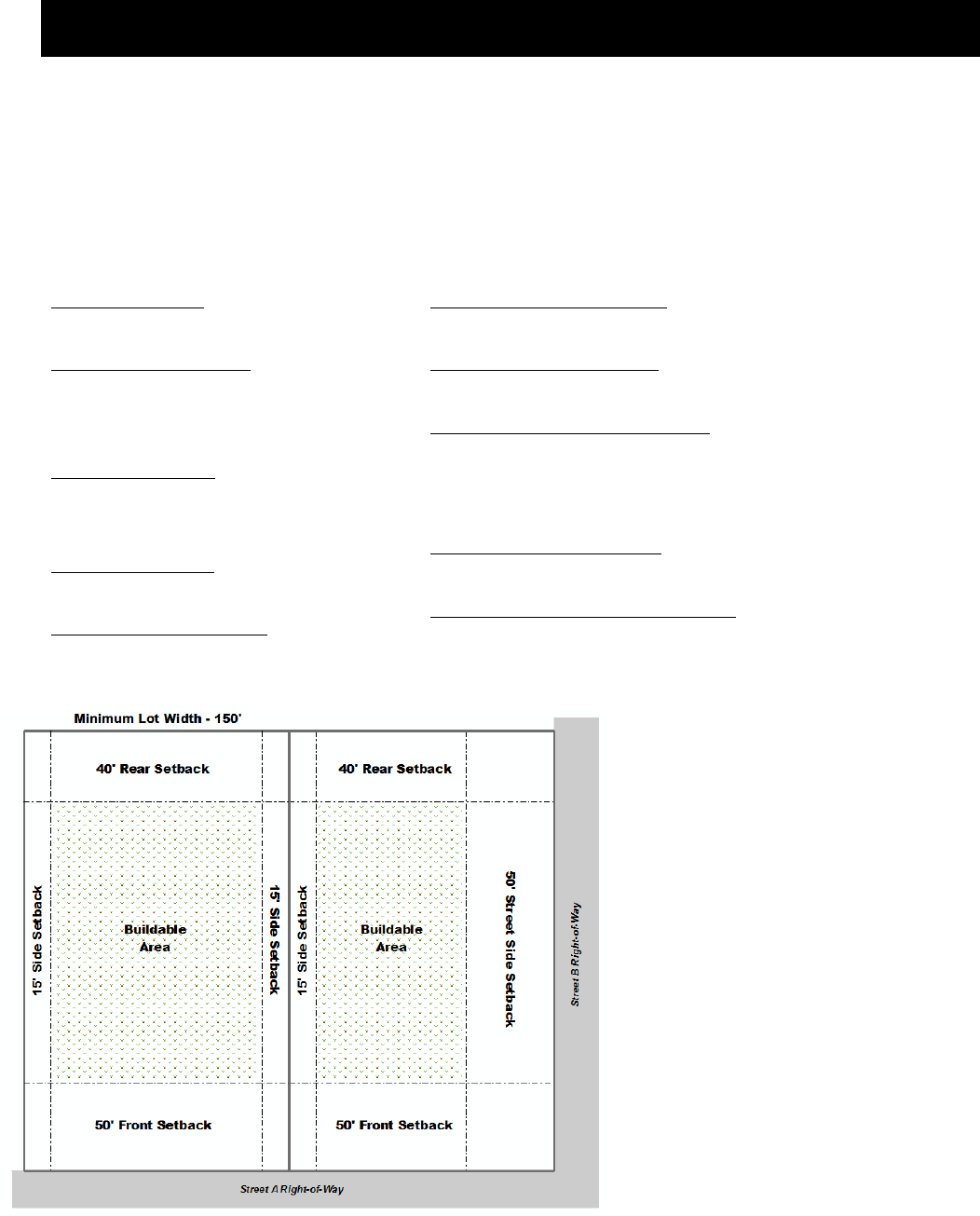
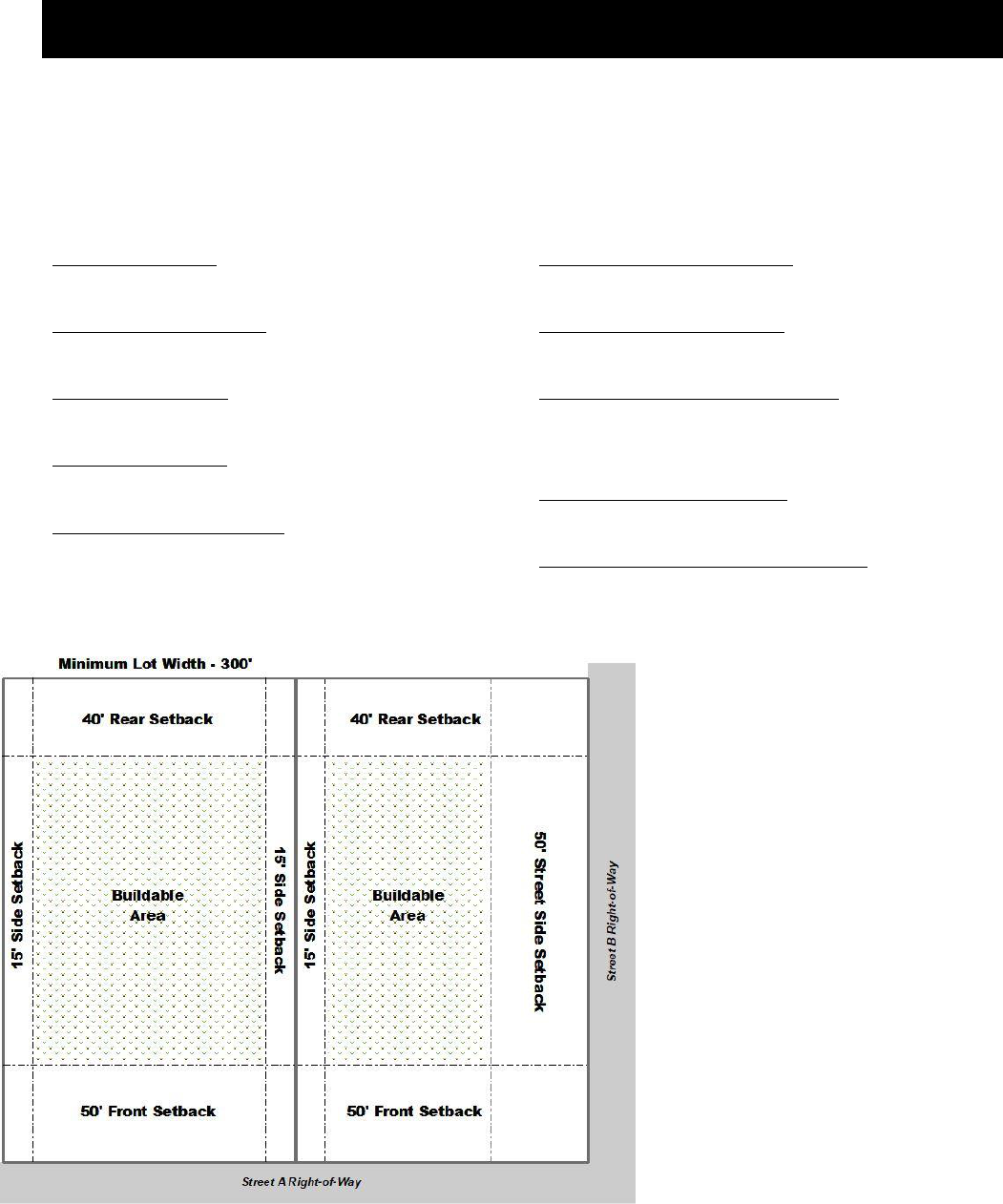
Sec. 020-020 AG-1 Agricultural/Residential District: Development Regulations
Minimum Lot Area:
43,560 square feet
Minimum Road Frontage:
150 feet for lots under 2.5 acres
300 feet for lots 2.5 acres or more
Minimum Lot Width:
150 feet for lots under 2.5 acres
300 feet for lots 2.5 acres or more
Minimum Lot Depth:
200 feet
Maximum Structure Height:
35 feet (agriculture structures are exempt)
Minimum Front Yard Setback:
50 feet
Minimum Side Yard Setback:
15 feet
Minimum Street Side Yard Setback:
50 feet; or
75 feet when adjacent to an arterial
roadway
Minimum Rear Yard Setback:
40 feet
Maximum Lot Coverage for Structures:
20 percent of the lot area
Additional Standards that may Apply:
Accessory Dwelling Units.…Sec 250-040
Accessory Uses & Struc.……Sec 250-030
Agritourism Buildings……….Sec 260-035
Barrel Warehouses……….....Sec 250-320
Brew pubs………………………..Sec 250-310
Distillery & Brewery………….Sec 250-300
Height………………………………Sec 330-010
Home Occupation…….…..….Sec 260-230
Fences & Walls…………….…..Sec 250-090
Capacity of Infrastructure…Division 270
Highway 53 Overlay Dist. ….Division245
Historic Preservation…………Division 240
Landscaping………………………Division 300
Lighting……………………………..Division 310
Parking………………………………Division 280
Signs……………………….…………Division 290

Oldham County Comprehensive Zoning Ordinance
Division 020 AG-1 Agricultural/Residential District
9
Sec. 020-030 AG-1 Agricultural/Residential
District: Permitted Uses
Sec. 020-040 AG-1 Agricultural/Residential
District: Conditional Uses
Agricultural Uses
Agricultural Uses
Game Farms
Community Facilities and Services
Colleges and Schools, Not for Profit
Community Centers, Not for Profit
Public and Government Buildings and Facilities
Public Utility Buildings & Facilities
Public Parks and Recreation
Boat Docks and Launching Areas
Recreational Camps/Resorts
Public Parks and Forest Preserves
Public Picnic Grounds, Beaches, Bridle and
Bicycle Paths
Religious Institutions
Churches and Other Religious Institutions
Residential
Accessory Dwelling Units (ADUs) – Attached
Accessory Dwelling Units (ADUs) - Interior
Dwellings – Single Family Detached
Residential Care Facility
Special
Lakes (man-made) non commercial
Commercial
Day Care Facilities for Four or More Children
(Up to 12 Children)
Veterinary Hospitals and Kennels
Community Facilities and Services
Private Utility Building and Facilities
Sewage Treatment Facilities
Light Industrial
Farm Implement Repair
Recreation
Aviaries and Zoos
Circus and Carnival Grounds
Commercial Rifle, Pistol and Skeet Ranges
Drive-in Theaters
Livestock Arenas
Marinas and Boat Rental
Private Clubs, Country Clubs and Golf Courses except
Miniature Courses and Commercial Driving Ranges
Recreational Vehicle Parks and Campgrounds
Swimming Pools, Tennis Courts & Similar Enterprises
Residential
Accessory Dwelling Units (ADUs) – Detached
Manufactured Homes – Single Family Detached
Special
Agritourism Buildings
Airports, Heliports & Other Airship or Flying Machine,
Take-off or Landing Facilities
Bed and Breakfasts
Borrow Pits, Quarry, Gravel Pit or Stone Mill
Cemeteries, Mausoleums and Crematories
Commercial Lakes
Extraction and Development of Natural Resources
Race Tracks
Oldham County Comprehensive Zoning Ordinance
Division 025 AG-2 Agricultural Business District
10
DIVISION 025 AG-2 AGRICULTURAL BUSINESS DISTRICT
Sec. 025-010 AG-2 Agricultural/Residential District: Intent
The AG-2 Agricultural Business District is intended to provide areas for agricultural development to allow
the means of earning supplemental income that can sustain local farms and contribute to the economic
base in Oldham County.
Sec. 025-020 AG-2 Agricultural/Residential District: Development Regulations
Minimum Lot Area:
5 Acres
Minimum Road Frontage:
300 feet
Minimum Lot Width:
300 feet
Minimum Lot Depth:
200 feet
Maximum Structure Height:
35 feet (agriculture structures are exempt)
Minimum Front Yard Setback:
50 feet
Minimum Side Yard Setback:
15 feet
Minimum Street Side Yard Setback:
50 feet; or
75 feet when adjacent to an arterial roadway
Minimum Rear Yard Setback:
40 feet
Maximum Lot Coverage for Structures:
20 percent of the lot area
Additional Standards that may Apply:
Accessory Dwelling Units.…Sec 250-040
Accessory Uses & Struc.……Sec 250-030
Agritourism Buildings……….Sec 260-035
Barrel Warehouses……….....Sec 250-320
Brew pubs………………………..Sec 250-310
Distillery & Brewery………….Sec 250-300
Height………………………………Sec 330-010
Home Occupation…….…..….Sec 260-230
Fences & Walls…………….…..Sec 250-090
Capacity of Infrastructure…Division 270
Highway 53 Overlay Dist. ….Division245
Historic Preservation…………Division 240
Landscaping………………………Division 300
Lighting……………………………..Division 310
Parking………………………………Division 280
Signs……………………….…………Division 290

Oldham County Comprehensive Zoning Ordinance
Division 020 AG-2 Agricultural/Residential District
11
Sec. 020-030 AG-2 Agricultural/Residential
District: Permitted Uses
Sec. 020-040 AG-1 Agricultural/Residential
District: Conditional Uses
Agricultural Uses
Agricultural Uses
Game Farms
Riding Academies & Stables
Agricultural Business
Distillery
Craft Distillery
Brewery
Microbrewery
Barrel Warehouses
Farm Implement Repair
Community Facilities and Services
Colleges and Schools, Not for Profit
Community Centers, Not for Profit
Public and Government Buildings and Facilities
Public Utility Buildings & Facilities
Public Parks and Recreation
Boat Docks and Launching Areas
Recreational Camps/Resorts
Public Parks and Forest Preserves
Public Picnic Grounds, Beaches, Bridle and
Bicycle Paths
Religious Institutions
Churches and Other Religious Institutions
Residential
Accessory Dwelling Units (ADUs) – Attached
Accessory Dwelling Units (ADUs) - Interior
Dwellings – Single Family Detached
Residential Care Facility
Special
Agritourism Buildings
Lakes (man-made) non commercial
Commercial
Day Care Facilities for Four or More Children
(Up to 12 Children)
Veterinary Hospitals and Kennels
Community Facilities and Services
Private Utility Building and Facilities
Sewage Treatment Facilities
Light Industrial
Farm Implement Repair
Recreation
Aviaries and Zoos
Circus and Carnival Grounds
Commercial Rifle, Pistol and Skeet Ranges
Drive-in Theaters
Livestock Arenas
Marinas and Boat Rental
Private Clubs, Country Clubs and Golf Courses except
Miniature Courses and Commercial Driving Ranges
Recreational Vehicle Parks and Campgrounds
Swimming Pools, Tennis Courts and Similar Enterprises
Residential
Accessory Dwelling Units (ADUs) – Detached
Manufactured Homes – Single Family Detached
Special
Airports, Heliports and Other Airship or Flying Machine
Take-off or Landing Facilities
Bed and Breakfasts
Borrow Pits, Quarry, Gravel Pit or Stone Mill
Cemeteries, Mausoleums and Crematories
Commercial Lakes
Extraction and Development of Natural Resources
Race Tracks
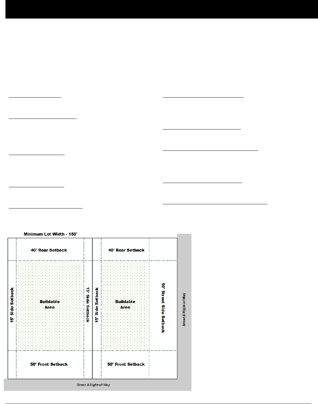
Oldham County Comprehensive Zoning Ordinance
Division 030 CO-1 Conservation/Residential District
12
DIVISION 030 CO-1 CONSERVATION/RESIDENTIAL DISTRICT
Sec. 030-010 CO-1 Conservation/Residential District: Intent
The Conservation/Residential District is intended to promote and protect significant natural features, wooded
areas, water courses, existing and potential lake sites, other recreational and conservation resources, wildlife
habitat, present and future water supplies, and to minimize erosion of soil and the siltation and pollution of
streams and lakes.
Sec. 030-020 CO-1 Agricultural/Residential District: Development Regulations
Minimum Lot Area:
43,560 square feet
Minimum Road Frontage:
150 feet for lots under 2.5 acres
300 feet for lots 2.5 acres or more
Minimum Lot Width:
150 feet for lots under 2.5 acres
300 feet for lots 2.5 acres or more
Minimum Lot Depth:
200 feet
Maximum Structure Height:
35 feet (agriculture structures are exempt)
Minimum Front Yard Setback:
50 feet; or
75 feet when adjacent to an arterial roadway
Minimum Side Yard Setback:
15 feet
Minimum Street Side Yard Setback:
50 feet; or
75 feet when adjacent to an arterial roadway
Minimum Rear Yard Setback:
40 feet
Maximum Lot Coverage for Structures:
20 percent of the lot area
Additional Standards that may Apply:
Accessory Dwelling Units.…Sec 250-040
Accessory Uses & Struc.……Sec 250-030
Agritourism Buildings……….Sec 260-035
Barrel Warehouses……….....Sec 250-320
Brew pubs………………………..Sec 250-310
Distillery & Brewery………….Sec 250-300
Height………………………………Sec 330-010
Home Occupation…….…..….Sec 260-230
Fences & Walls…………….…..Sec 250-090
Capacity of Infrastructure…Division 270
Highway 53 Overlay Dist. ….Division245
Historic Preservation…………Division 240
Landscaping………………………Division 300
Lighting……………………………..Division 310
Parking………………………………Division 280
Signs……………………….…………Division 290

Oldham County Comprehensive Zoning Ordinance
Division 030 CO-1 Conservation/Residential District
13
Sec. 030-030 CO-1 Agricultural/Residential
District: Permitted Uses
Sec. 030-040 CO-1 Agricultural/Residential
District: Conditional Uses
Agricultural Uses
Agricultural Uses
Game Farms
Community Facilities and Services
Colleges and Schools, Not for Profit
Community Centers, Not for Profit
Public and Government Buildings and Facilities
Public Utility Buildings & Facilities
Public Parks and Recreation
Boat Docks and Launching Areas
Recreational Camps/Resorts
Public Parks and Forest Preserves
Public Picnic Grounds, Beaches, Bridle and
Bicycle Paths
Religious Institutions
Churches and Other Religious Institutions
Residential
Accessory Dwelling Units (ADUs) – Attached
Accessory Dwelling Units (ADUs) - Interior
Dwellings – Single Family Detached
Residential Care Facility
Special
Lakes (man-made) non commercial
Commercial
Veterinary Hospitals and Kennels
Community Facilities and Services
Private Utility Building and Facilities
Sewage Treatment Facilities
Residential
Accessory Dwelling Units (ADUs) – Detached
Recreation
Aviaries and Zoos
Commercial Rifle, Pistol and Skeet Ranges
Livestock Arenas
Marinas and Boat Rental
Private Clubs, Country Clubs and Golf Courses except
Miniature Courses and Commercial Driving Ranges
Recreational Vehicle Parks and Campgrounds
Swimming Pools, Tennis Courts and Similar Enterprises
Special
Agritourism Buildings
Bed and Breakfasts
Borrow Pits, Quarry, Gravel Pit or Stone Mill
Commercial Lakes
Extraction and Development of Natural Resources

Oldham County Comprehensive Zoning Ordinance
Division 040 R-1A Residential District
14
DIVISION 040 R-1A RESIDENTIAL DISTRICT
Sec. 040-010 R-1A Residential District: Intent
The purpose of the R-1A Residential District is to allow, preserve and protect the character of low density,
detached single-family areas and neighborhoods at densities ranging from one (1) dwelling unit per acre up to
1.74 dwelling units per acre.
Sec. 040-020 R-1A Residential District: Development Regulations
Minimum Lot Area:
25,000 square feet with sanitary sewers
43,560 square feet without sanitary sewers
43,560 square feet within the city of Pewee Valley
Minimum Lot Width:
100 feet; or
150 feet for lots without sanitary sewers
Maximum Density/Intensity:
1.74 dwelling units per acre
0.25 Floor Area Ratio
Maximum Structure Height:
35 feet (agriculture structures are exempt)
Minimum Front Yard Setback:
35 feet
Minimum Side Yard Setback:
15 feet
30 feet total for both sides
Minimum Street Side Yard Setback:
35 feet
Minimum Rear Yard Setback:
30 feet
Maximum Lot Coverage for Structures:
30 percent of the lot area
Additional Standards that may Apply:
Accessory Dwelling Units.…Sec 250-040
Accessory Uses & Struc.……Sec 250-030
Agritourism Buildings……….Sec 260-035
Barrel Warehouses……….....Sec 250-320
Brew pubs………………………..Sec 250-310
Distillery & Brewery………….Sec 250-300
Height………………………………Sec 330-010
Home Occupation…….…..….Sec 260-230
Fences & Walls…………….…..Sec 250-090
Capacity of Infrastructure…Division 270
Highway 53 Overlay Dist. ….Division245
Historic Preservation…………Division 240
Landscaping………………………Division 300
Lighting……………………………..Division 310
Parking………………………………Division 280
Signs……………………….…………Division 290

Oldham County Comprehensive Zoning Ordinance
Division 040 R-1A Residential District
15
Sec. 040-030 R-1A Residential District:
Permitted Uses
Sec. 040-040 R-1A Residential District:
Conditional Uses
Agricultural Uses
Agricultural Uses
Community Facilities and Services
Colleges and Schools, Not for Profit
Community Centers, Not for Profit
Public and Government Buildings and Facilities
Public Utility Buildings & Facilities
Public Parks and Recreation
Boat Docks and Launching Areas
Recreational Camps/Resorts
Public Parks and Forest Preserves
Public Picnic Grounds, Beaches, Bridle and
Bicycle Paths
Religious Institutions
Churches and Other Religious Institutions
Residential
Accessory Dwelling Units (ADUs) – Attached
Accessory Dwelling Units (ADUs) - Interior
Dwellings – Single Family Detached
Residential Care Facility
Special
Lakes (man-made) non commercial
Agricultural Uses
Riding Academies and Stables Less than 5 Acres
Commercial
Day Care Facilities for Four or More Children
(Up to 12 Children)
Veterinary Hospitals and Kennels
Community Facilities and Services
Private Utility Building and Facilities
Recreation
Marinas and Boat Rental
Private Clubs, Country Clubs and Golf Courses except
Miniature Courses and Commercial Driving Ranges
Recreational Vehicle Parks and Campgrounds
Swimming Pools, Tennis Courts and Similar Enterprises
Residential
Accessory Dwelling Units (ADUs) - Detached
Manufactured Homes – Single Family Detached
Nursing Homes
Special
Agritourism Buildings
Borrow Pits, Quarry, Gravel Pit or Stone Mill
Cemeteries, Mausoleums and Crematories
Commercial Lakes
Extraction and Development of Natural Resources
Heliports and Other Airship or Flying Machine Take-off
or Landing Facilities
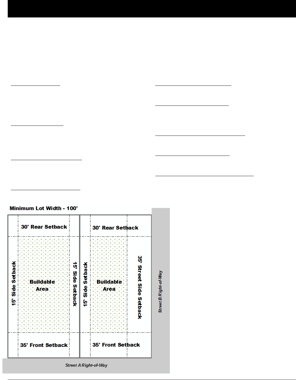
Oldham County Comprehensive Zoning Ordinance
Division 050 R-1 Residential District
16
DIVISION 050 R-1 RESIDENTIAL DISTRICT
Sec. 050-010 R-1 Residential District: Intent
The purpose of the R-1 Residential District is to allow, preserve and protect the character of low density,
detached single-family areas and neighborhoods at densities ranging from one (1) dwelling unit per acre
up to 2.17 dwelling units per acre.
Sec. 050-020 R-1 Residential District: Development Regulations
Minimum Lot Area:
20,000 square feet with sanitary sewers
43,560 square feet without sanitary sewers
43,560 square feet within the city of Pewee Valley
Minimum Lot Width:
100 feet; or
150 feet for lots without sanitary sewers
Maximum Density/Intensity:
2.17 dwelling units per acre
0.25 Floor Area Ratio
Maximum Structure Height:
35 feet (agriculture structures are exempt)
Minimum Front Yard Setback:
35 feet
Minimum Side Yard Setback:
15 feet
30 feet total for both sides
Minimum Street Side Yard Setback:
35 feet
Minimum Rear Yard Setback:
30 feet
Maximum Lot Coverage for Structures:
30 percent of the lot area
Additional Standards that may Apply:
Accessory Dwelling Units.…Sec 250-040
Accessory Uses & Struc.……Sec 250-030
Agritourism Buildings……….Sec 260-035
Barrel Warehouses……….....Sec 250-320
Brew pubs………………………..Sec 250-310
Distillery & Brewery………….Sec 250-300
Height………………………………Sec 330-010
Home Occupation…….…..….Sec 260-230
Fences & Walls…………….…..Sec 250-090
Capacity of Infrastructure…Division 270
Highway 53 Overlay Dist. ….Division245
Historic Preservation…………Division 240
Landscaping………………………Division 300
Lighting……………………………..Division 310
Parking………………………………Division 280
Signs……………………….…………Division 290

Oldham County Comprehensive Zoning Ordinance
Division 050 R-1 Residential District
17
Sec. 050-030 R-1 Residential District:
Permitted Uses
Sec. 050-040 R-1 Residential District:
Conditional Uses
Agricultural Uses
Agricultural Uses
Community Facilities and Services
Colleges and Schools, Not for Profit
Community Centers, Not for Profit
Public and Government Buildings and Facilities
Public Utility Buildings & Facilities
Public Parks and Recreation
Boat Docks and Launching Areas
Recreational Camps/Resorts
Public Parks and Forest Preserves
Public Picnic Grounds, Beaches, Bridle and
Bicycle Paths
Religious Institutions
Churches and Other Religious Institutions
Residential
Accessory Dwelling Units (ADUs) – Attached
Accessory Dwelling Units (ADUs) - Interior
Dwellings – Single Family Detached
Residential Care Facility
Special
Lakes (man-made) non commercial
Agricultural Uses
Riding Academies and Stables Less than 5 Acres
Commercial
Day Care Facilities for Four or More Children
(Up to 12 Children)
Veterinary Hospitals and Kennels
Community Facilities and Services
Private Utility Building and Facilities
Recreation
Marinas and Boat Rental
Private Clubs, Country Clubs and Golf Courses except
Miniature Courses and Commercial Driving Ranges
Swimming Pools, Tennis Courts and Similar Enterprises
Residential
Accessory Dwelling Units (ADUs) - Detached
Manufactured Homes – Single Family Detached
Nursing Homes
Special
Agritourism Buildings
Borrow Pits, Quarry, Gravel Pit or Stone Mill
Cemeteries, Mausoleums and Crematories
Commercial Lakes
Extraction and Development of Natural Resources
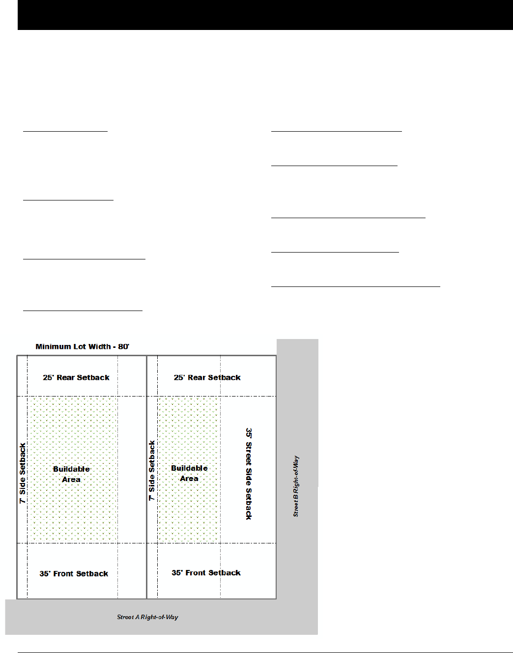
Oldham County Comprehensive Zoning Ordinance
Division 060 R-2 Residential District
18
DIVISION 060 R-2 RESIDENTIAL DISTRICT
Sec. 060-010 R-2 Residential District: Intent
The purpose of the R-2 Residential District is to allow, preserve and protect the character of low density,
detached single-family areas and neighborhoods at densities up to 3.63 dwelling units per acre.
Sec. 060-020 R-2 Residential District: Development Regulations
Minimum Lot Area:
12,000 square feet with sanitary sewers
43,560 square feet without sanitary sewers
43,560 square feet within the city of Pewee Valley
Minimum Lot Width:
80 feet; or
150 feet for lots without sanitary sewers
Maximum Density/Intensity:
3.63 dwelling units per acre
0.35 Floor Area Ratio
Maximum Structure Height:
35 feet (agriculture structures are exempt)
Minimum Front Yard Setback:
35 feet
Minimum Side Yard Setback:
7 feet
25 feet total for both sides
Minimum Street Side Yard Setback:
35 feet
Minimum Rear Yard Setback:
25 feet
Maximum Lot Coverage for Structures:
30 percent of the lot area
Additional Standards that may Apply:
Accessory Dwelling Units.…Sec 250-040
Accessory Uses & Struc.……Sec 250-030
Agritourism Buildings……….Sec 260-035
Barrel Warehouses……….....Sec 250-320
Brew pubs………………………..Sec 250-310
Distillery & Brewery………….Sec 250-300
Height………………………………Sec 330-010
Home Occupation…….…..….Sec 260-230
Fences & Walls…………….…..Sec 250-090
Capacity of Infrastructure…Division 270
Highway 53 Overlay Dist. ….Division245
Historic Preservation…………Division 240
Landscaping………………………Division 300
Lighting……………………………..Division 310
Parking………………………………Division 280
Signs……………………….…………Division 290

Oldham County Comprehensive Zoning Ordinance
Division 060 R-2 Residential District
19
Sec. 060-030 R-2 Residential District:
Permitted Uses
Sec. 060-040 R-2 Residential District:
Conditional Uses
Agricultural Uses
Agricultural Uses
Community Facilities and Services
Colleges and Schools, Not for Profit
Community Centers, Not for Profit
Public and Government Buildings and Facilities
Public Utility Buildings & Facilities
Public Parks and Recreation
Boat Docks and Launching Areas
Public Parks and Forest Preserves
Public Picnic Grounds, Beaches, Bridle and
Bicycle Paths
Religious Institutions
Churches and Other Religious Institutions
Residential
Accessory Dwelling Units (ADUs) – Attached
Accessory Dwelling Units (ADUs) - Interior
Dwellings – Single Family Detached
Residential Care Facility
Special
Lakes (man-made) non commercial
Agricultural Uses
Riding Academies and Stables Less than 5 Acres
Commercial
Day Care Facilities for Four or More Children
(Up to 12 Children)
Community Facilities and Services
Hospitals and Institutions
Private Utility Building and Facilities
Recreation
Marinas and Boat Rental
Private Clubs, Country Clubs and Golf Courses except
Miniature Courses and Commercial Driving Ranges
Recreational Camps/Resorts
Swimming Pools, Tennis Courts and Similar Enterprises
Residential
Accessory Dwelling Units (ADUs) - Detached
Manufactured Homes – Single Family Detached
Nursing Homes
Special
Agritourism Buildings
Borrow Pits, Quarry, Gravel Pit or Stone Mill
Cemeteries, Mausoleums and Crematories
Commercial Lakes
Extraction and Development of Natural Resources
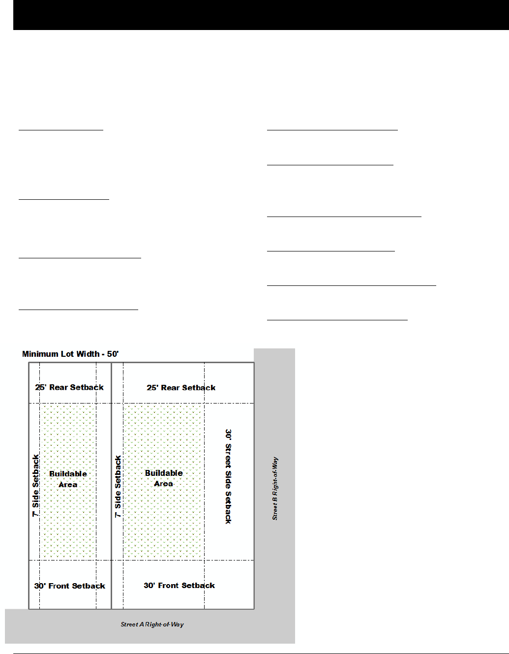
Oldham County Comprehensive Zoning Ordinance
Division 070 R-2A Residential District
20
DIVISION 070 R-2A RESIDENTIAL DISTRICT
Sec. 070-010 R-2A Residential District: Intent
The purpose of the R-2A Residential District is to allow, preserve and protect the character of low to medium
density, detached single-family areas and neighborhoods at densities up to 5.81 dwelling units per acre.
Sec. 070-020 R-2A Residential District: Development Regulations
Minimum Lot Area:
7,500 square feet with sanitary sewers
43,560 square feet without sanitary sewers
43,560 square feet within the city of Pewee Valley
Minimum Lot Width:
50 feet; or
150 feet for lots without sanitary sewers
Maximum Density/Intensity:
5.81 dwelling units per acre
0.50 Floor Area Ratio
Maximum Structure Height:
35 feet (agriculture structures are exempt)
Minimum Front Yard Setback:
30 feet
Minimum Side Yard Setback:
7 feet
16 feet total for both sides
Minimum Street Side Yard Setback:
30 feet
Minimum Rear Yard Setback:
25 feet
Maximum Lot Coverage for Structures:
30 percent of the lot area
Minimum Common Open Space:
250 square feet per dwelling unit
Additional Standards that may Apply:
Accessory Dwelling Units.…Sec 250-040
Accessory Uses & Struc.……Sec 250-030
Agritourism Buildings……….Sec 260-035
Barrel Warehouses……….....Sec 250-320
Brew pubs………………………..Sec 250-310
Distillery & Brewery………….Sec 250-300
Height………………………………Sec 330-010
Home Occupation…….…..….Sec 260-230
Fences & Walls…………….…..Sec 250-090
Capacity of Infrastructure…Division 270
Highway 53 Overlay Dist. ….Division245
Historic Preservation…………Division 240
Landscaping………………………Division 300
Lighting……………………………..Division 310
Parking………………………………Division 280
Signs……………………….…………Division 290

Oldham County Comprehensive Zoning Ordinance
Division 070 R-2A Residential District
21
Sec. 070-030 R-2A Residential District:
Permitted Uses
Sec. 070-040 R-2A Residential District:
Conditional Uses
Agricultural Uses
Agricultural Uses
Community Facilities and Services
Colleges and Schools, Not for Profit
Community Centers, Not for Profit
Public and Government Buildings and Facilities
Public Utility Buildings & Facilities
Public Parks and Recreation
Public Parks and Forest Preserves
Public Picnic Grounds, Beaches, Bridle and
Bicycle Paths
Religious Institutions
Churches and Other Religious Institutions
Residential
Accessory Dwelling Units (ADUs) – Attached
Accessory Dwelling Units (ADUs) - Interior
Dwellings – Single Family Detached
Residential Care Facility
Special
Lakes (man-made) non commercial
Agricultural Uses
Riding Academies and Stables Less than 5 Acres
Commercial
Day Care Facilities for Four or More Children
(Up to 12 Children)
Community Facilities and Services
Hospitals and Institutions
Private Utility Building and Facilities
Recreation
Marinas and Boat Rental
Private Clubs, Country Clubs and Golf Courses except
Miniature Courses and Commercial Driving Ranges
Swimming Pools, Tennis Courts and Similar Enterprises
Residential
Accessory Dwelling Units (ADUs) - Detached
Nursing Homes
Special
Agritourism Buildings
Borrow Pits, Quarry, Gravel Pit or Stone Mill
Cemeteries, Mausoleums and Crematories
Commercial Lakes
Extraction and Development of Natural Resources
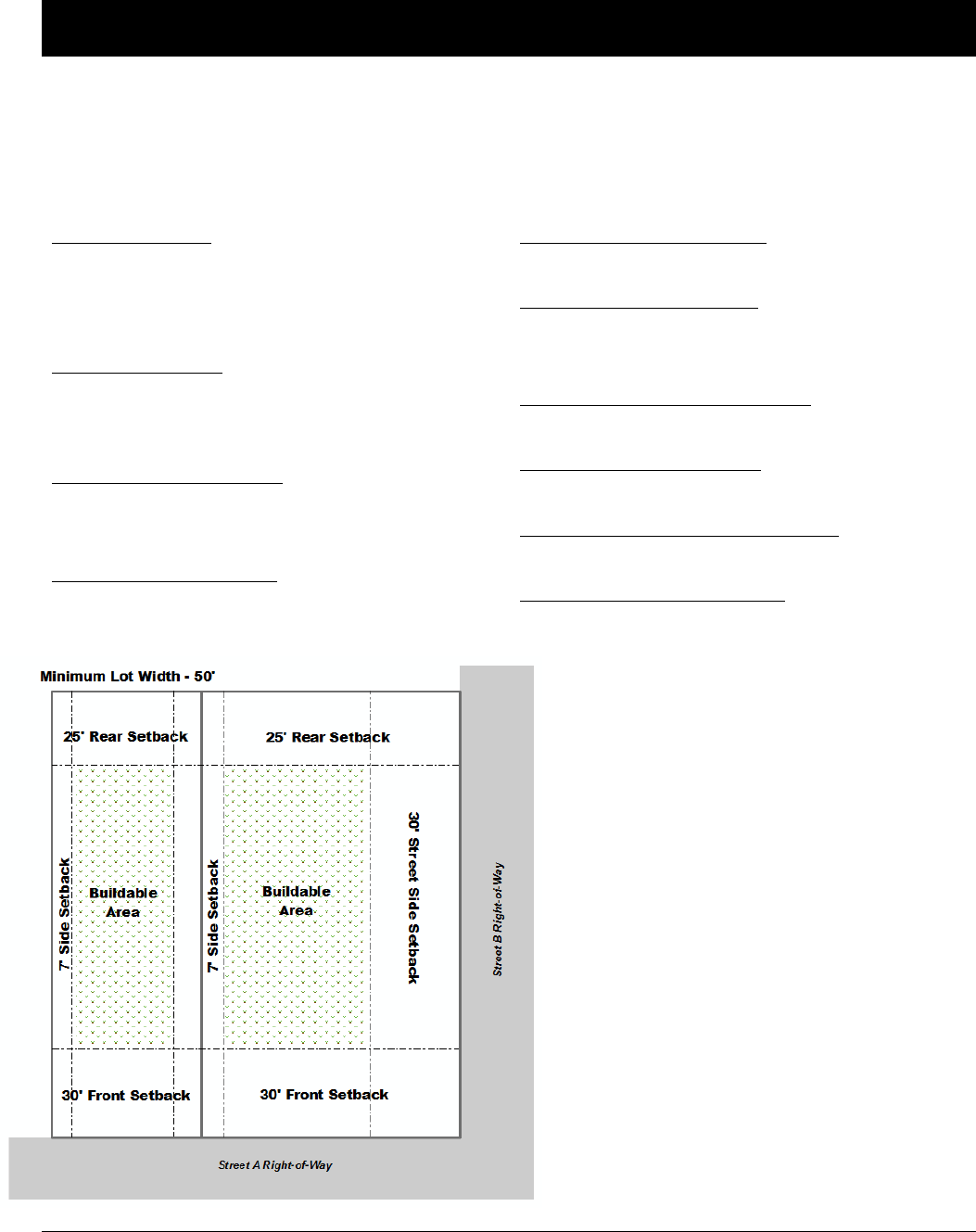
Oldham County Comprehensive Zoning Ordinance
Division 080 R-3 Residential District
22
DIVISION 080 R-3 RESIDENTIAL DISTRICT
Sec. 080-010 R-3 Residential District: Intent
The purpose of the R-3 Residential District is to allow, preserve and protect the character of low to medium density,
detached single-family and two-family areas and neighborhoods at densities up to 5.81 dwelling units per acre.
Sec. 080-020 R-3 Residential District: Development Regulations
Minimum Lot Area:
7,500 square feet with sanitary sewers
43,560 square feet without sanitary sewers
43,560 square feet within the city of Pewee Valley
Minimum Lot Width:
50 feet; or
150 feet for lots without sanitary sewers
Maximum Density/Intensity:
5.81 dwelling units per acre
0.50 Floor Area Ratio
Maximum Structure Height:
35 feet (agriculture structures are exempt)
Minimum Front Yard Setback:
30 feet
Minimum Side Yard Setback:
7 feet
16 feet total for both sides
Minimum Street Side Yard Setback:
30 feet
Minimum Rear Yard Setback:
25 feet
Maximum Lot Coverage for Structures:
30 percent of the lot area
Minimum Common Open Space:
250 square feet per dwelling unit
Additional Standards that may Apply:
Accessory Dwelling Units.…Sec 250-040
Accessory Uses & Struc.……Sec 250-030
Agritourism Buildings……….Sec 260-035
Barrel Warehouses……….....Sec 250-320
Brew pubs………………………..Sec 250-310
Distillery & Brewery………….Sec 250-300
Height………………………………Sec 330-010
Home Occupation…….…..….Sec 260-230
Fences & Walls…………….…..Sec 250-090
Capacity of Infrastructure…Division 270
Highway 53 Overlay Dist. ….Division245
Historic Preservation…………Division 240
Landscaping………………………Division 300
Lighting……………………………..Division 310
Parking………………………………Division 280
Signs……………………….…………Division 290

Oldham County Comprehensive Zoning Ordinance
Division 080 R-3 Residential District
23
Sec. 080-030 R-3 Residential District:
Permitted Uses
Sec. 080-040 R-3 Residential District:
Conditional Uses
Agricultural Uses
Agricultural Uses
Community Facilities and Services
Colleges and Schools, Not for Profit
Community Centers, Not for Profit
Public and Government Buildings and Facilities
Public Utility Buildings & Facilities
Public Parks and Recreation
Public Parks and Forest Preserves
Public Picnic Grounds, Beaches, Bridle and
Bicycle Paths
Religious Institutions
Churches and Other Religious Institutions
Residential
Dwellings – Single Family Detached
Dwellings – Two Family
Residential Care Facility
Special
Lakes (man-made) non commercial
Agricultural Uses
Riding Academies and Stables Less than 5 Acres
Commercial
Day Care Facilities for Four or More Children
(Up to 12 Children)
Community Facilities and Services
Hospitals and Institutions
Private Utility Building and Facilities
Recreation
Marinas and Boat Rental
Private Clubs, Country Clubs and Golf Courses except
Miniature Courses and Commercial Driving Ranges
Recreational Vehicle Parks and Campgrounds
Swimming Pools, Tennis Courts and Similar Enterprises
Residential
Nursing Homes
Special
Agritourism Buildings
Borrow Pits, Quarry, Gravel Pit or Stone Mill
Cemeteries, Mausoleums and Crematories
Commercial Lakes
Extraction and Development of Natural Resources
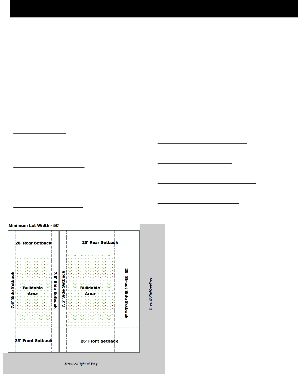
Oldham County Comprehensive Zoning Ordinance
Division 090 R-4 Residential District
24
DIVISION 090 R-4 RESIDENTIAL DISTRICT
Sec. 090-010 R-4 Residential District: Intent
The purpose of the R-4 Residential District is to allow higher density residential uses and low intensity non-
residential uses which are served by adequate infrastructure, while maintaining the unique character of
neighborhoods at densities up to 16 units per acre. This district is used to encourage a variety of residential
opportunities.
Sec. 090-020 R-4 Residential District: Development Regulations
Minimum Lot Area:
6,000 square feet with sanitary sewers
43,560 square feet without sanitary sewers
43,560 square feet within the city of Pewee Valley
Minimum Lot Width:
50 feet; or
150 feet for lots without sanitary sewers
Maximum Density/Intensity:
16 dwelling units per acre
4 dwelling units per acre without sanitary sewers
0.50 Floor Area Ratio
Maximum Structure Height:
45 feet (agriculture structures are exempt)
Minimum Front Yard Setback:
25 feet
Minimum Side Yard Setback:
7.5 feet plus 3 feet for each story over three
15 feet plus 6 feet for each story over three total
Minimum Street Side Yard Setback:
25 feet
Minimum Rear Yard Setback:
25 feet
Maximum Lot Coverage for Structures:
50 percent of the lot area
Minimum Common Open Space:
250 square feet per dwelling unit
Additional Standards that may Apply:
Accessory Dwelling Units.…Sec 250-040
Accessory Uses & Struc.……Sec 250-030
Agritourism Buildings……….Sec 260-035
Barrel Warehouses……….....Sec 250-320
Brew pubs………………………..Sec 250-310
Distillery & Brewery………….Sec 250-300
Height………………………………Sec 330-010
Home Occupation…….…..….Sec 260-230
Fences & Walls…………….…..Sec 250-090
Capacity of Infrastructure…Division 270
Highway 53 Overlay Dist. ….Division245
Historic Preservation…………Division 240
Landscaping………………………Division 300
Lighting……………………………..Division 310
Parking………………………………Division 280
Signs……………………….…………Division 290

Oldham County Comprehensive Zoning Ordinance
Division 090 R-4 Residential District
25
Sec. 090-030 R-4 Residential District:
Permitted Uses
Sec. 090-040 R-4 Residential District:
Conditional Uses
Agricultural Uses
Agricultural Uses
Community Facilities and Services
Colleges and Schools, Not for Profit
Community Centers, Not for Profit
Public and Government Buildings and Facilities
Public Utility Buildings & Facilities
Office
Professional Offices
Public Parks and Recreation
Public Parks and Forest Preserves
Public Picnic Grounds, Beaches, Bridle and
Bicycle Paths
Religious Institutions
Churches and Other Religious Institutions
Residential
Dwellings – Single Family Detached
Dwellings – Multi Family
Dwellings – Two Family
Residential Care Facility
Special
Lakes (man-made) non commercial
Agricultural Uses
Riding Academies and Stables Less than 5 Acres
Commercial
Day Care Facilities for Four or More Children
(Up to 12 Children)
Community Facilities and Services
Hospitals and Institutions
Private Utility Building and Facilities
Recreation
Boat Docks and Launching Areas
Marinas and Boat Rental
Private Clubs, Country Clubs and Golf Courses except
Miniature Courses and Commercial Driving Ranges
Recreational Camps/Resorts
Swimming Pools, Tennis Courts and Similar Enterprises
Residential
Nursing Homes
Special
Agritourism Buildings
Borrow Pits, Quarry, Gravel Pit or Stone Mill
Cemeteries, Mausoleums and Crematories
Commercial Lakes
Extraction and Development of Natural Resources
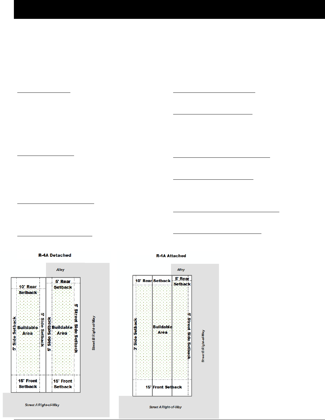
Oldham County Comprehensive Zoning Ordinance
Division 100 R-4A Residential District
26
DIVISION 100 R-4A RESIDENTIAL DISTRICT
Sec. 100-010 R-4A Residential District: Intent
The purpose of the R-4A Residential District is to allow, preserve and protect the character of medium
density, attached single-family and two-family areas and neighborhoods at densities up to 8 dwelling units
per acre, and to permit a fee simple option (lot standards) to Conventional Condominium Development.
Sec. 100-020 R-4A Residential District: Development Regulations
Minimum Lot Area:
3,000 square feet for detached structures
2,000 square feet per dwelling unit for attached
structures
43,560 square feet without sanitary sewers
43,560 square feet within the city of Pewee Valley
Minimum Lot Width:
30 feet for detached structures
18 feet for attached structures
150 feet for lots without sanitary sewers
Maximum Density/Intensity:
8 dwelling units per acre
2.0 Floor Area Ratio
Maximum Structure Height:
35 feet (agriculture structures are exempt)
Minimum Front Yard Setback:
15 feet
Minimum Side Yard Setback:
5 feet for detached structures
0 feet for attached structures
3 feet for end unit of attached structures
Minimum Street Side Yard Setback:
5 feet
Minimum Rear Yard Setback:
10 feet; or
5 feet if alleys are used with detached garages
Maximum Lot Coverage for Structures:
85 percent of the lot area
Minimum Common Open Space:
500 square feet per dwelling unit
Additional Standards that may Apply:
Accessory Dwelling Units.…Sec 250-040
Accessory Uses & Struc.……Sec 250-030
Agritourism Buildings……….Sec 260-035
Barrel Warehouses……….....Sec 250-320
Brew pubs………………………..Sec 250-310
Distillery & Brewery………….Sec 250-300
Height………………………………Sec 330-010
Home Occupation…….…..….Sec 260-230
Fences & Walls…………….…..Sec 250-090
Capacity of Infrastructure…Division 270
Highway 53 Overlay Dist. ….Division245
Historic Preservation…………Division 240
Landscaping………………………Division 300
Lighting……………………………..Division 310
Parking………………………………Division 280
Signs……………………….…………Division 290

Oldham County Comprehensive Zoning Ordinance
Division 100 R-4A Residential District
27
Sec. 100-030 R-4A Residential District:
Permitted Uses
Sec. 100-040 R-4A Residential District:
Conditional Uses
Agricultural Uses
Agricultural Uses
Community Facilities and Services
Colleges and Schools, Not for Profit
Community Centers, Not for Profit
Public and Government Buildings and Facilities
Public Utility Buildings & Facilities
Public Parks and Recreation
Public Parks and Forest Preserves
Public Picnic Grounds, Beaches, Bridle and
Bicycle Paths
Religious Institutions
Churches and Other Religious Institutions
Residential
Dwellings – Single Family Detached
Dwellings – Multi Family (a maximum of four attached
units per structure
Residential Care Facility
Special
Lakes (man-made) non commercial
Agricultural Uses
Riding Academies and Stables Less than 5 Acres
Commercial
Day Care Facilities for Four or More Children
(Up to 12 Children)
Community Facilities and Services
Hospitals and Institutions
Private Utility Building and Facilities
Recreation
Boat Docks and Launching Areas
Marinas and Boat Rental
Private Clubs, Country Clubs and Golf Courses except
Miniature Courses and Commercial Driving Ranges
Recreational Camps/Resorts
Swimming Pools, Tennis Courts and Similar Enterprises
Residential
Nursing Homes
Special
Agritourism Buildings
Borrow Pits, Quarry, Gravel Pit or Stone Mill
Cemeteries, Mausoleums and Crematories
Commercial Lakes
Extraction and Development of Natural Resources
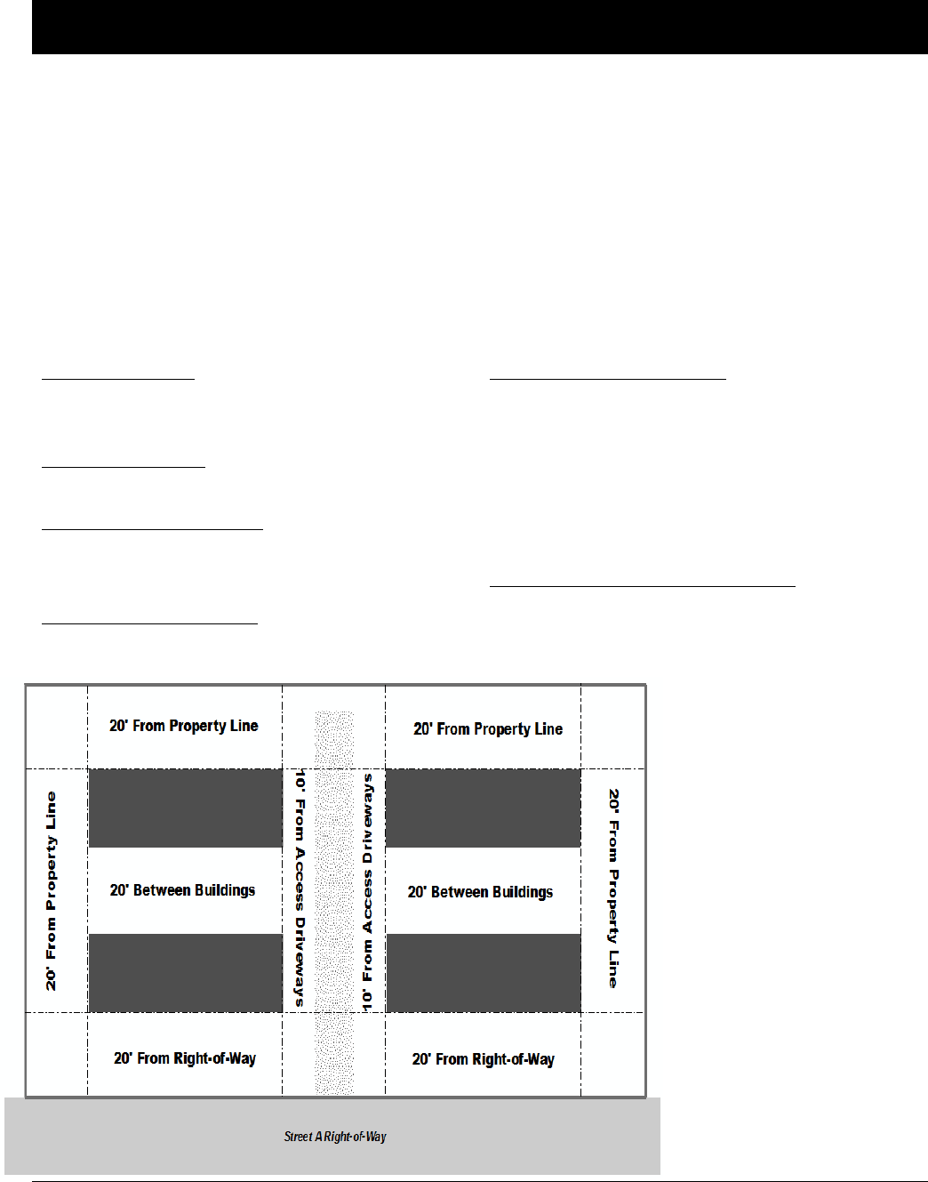
Oldham County Comprehensive Zoning Ordinance
Division 110 T Manufactured Home District
28
DIVISION 110 T MANUFACTURED HOME DISTRICT
Sec. 110-010 T Manufactured Home District: Intent
It is the intent of this district to permit the establishment of manufactured home parks in areas in the county,
or in areas within the municipalities, that best provide the proper facilities and setting for a manufactured home
park development. This district should be provided with access to major traffic arterial streets and the
necessary community facilities. Manufactured home parks themselves required special consideration as to the
circumstances and conditions under which each such use may be permitted in order to provide adequate
protection for, and consideration of, both the community and the manufactured home dweller.
Sec. 110-020, A. T Manufactured Home District: Development Regulations for Manufactured
Homes
Minimum Lot Area:
5,000 square feet for each manufactured home space
or lot
Minimum Lot Width:
40 feet of frontage on an improved access road
Maximum Density/Intensity:
8 dwelling units per acre
0.5 Floor Area Ratio
Maximum Structure Height:
25 feet
Minimum Front Yard Setback:
10 feet from an access road or access driveway
20 feet from any other manufactured home and
service building or area
10 feet from any exterior property line of the
manufactured home park
20 feet from any street or dedicated rights-of-way
Maximum Lot Coverage for Structures:
35 percent of the lot area
Additional Standards that may Apply:
Accessory Dwelling Units.…Sec 250-040
Accessory Uses & Struc.……Sec 250-030
Agritourism Buildings……….Sec 260-035
Barrel Warehouses……….....Sec 250-320
Brew pubs………………………..Sec 250-310
Distillery & Brewery………….Sec 250-300
Height………………………………Sec 330-010
Home Occupation…….…..….Sec 260-230
Fences & Walls…………….…..Sec 250-090
Capacity of Infrastructure…Division 270
Highway 53 Overlay Dist. ….Division245
Historic Preservation…………Division 240
Landscaping………………………Division 300
Lighting……………………………..Division 310
Parking………………………………Division 280
Signs……………………….…………Division 290
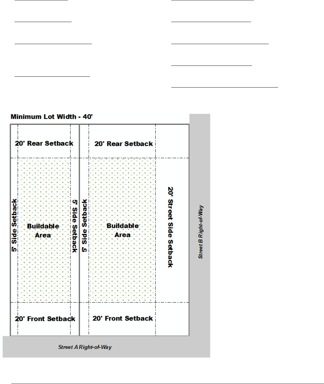
Oldham County Comprehensive Zoning Ordinance
Division 110 T Manufactured Home District
29
Sec. 110-020, B. T Manufactured Home District: Development Regulations for Non-
Manufactured Homes
Minimum Lot Area:
5,000 square feet
Minimum Lot Width:
40 feet
Maximum Density/Intensity:
8 dwelling units per acre
0.5 Floor Area Ratio
Maximum Structure Height:
35 feet (agricultural structures are exempt)
Minimum Front Yard Setback:
20 feet
Minimum Side Yard Setback:
5 feet
Minimum Street Side Yard Setback:
20 feet
Minimum Rear Yard Setback:
20 feet
Maximum Lot Coverage for Structures:
50 percent of the lot area
Additional Standards that may Apply:
Accessory Dwelling Units.…Sec 250-040
Accessory Uses & Struc.……Sec 250-030
Agritourism Buildings……….Sec 260-035
Barrel Warehouses……….....Sec 250-320
Brew pubs………………………..Sec 250-310
Distillery & Brewery………….Sec 250-300
Height………………………………Sec 330-010
Home Occupation…….…..….Sec 260-230
Fences & Walls…………….…..Sec 250-090
Capacity of Infrastructure…Division 270
Highway 53 Overlay Dist. ….Division245
Historic Preservation…………Division 240
Landscaping………………………Division 300
Lighting……………………………..Division 310
Parking………………………………Division 280
Signs……………………….…………Division 290

Oldham County Comprehensive Zoning Ordinance
Division 110 T Manufactured Home District
30
Sec. 110-030 T Manufactured Home District:
Permitted Uses
Sec. 110-040 T Manufactured Home District:
Conditional Uses
Agricultural Uses
Agricultural Uses
Community Facilities and Services
Colleges and Schools, Not for Profit
Community Centers, Not for Profit
Public and Government Buildings and Facilities
Public Utility Buildings & Facilities
Recreational Camps/Resorts
Public Parks and Recreation
Boat Docks and Launching Areas
Public Parks and Forest Preserves
Public Picnic Grounds, Beaches, Bridle and
Bicycle Paths
Religious Institutions
Churches and Other Religious Institutions
Residential
Dwellings – Single Family Detached
Manufactured Homes –
New single-family manufactured homes bearing HUD
labels
Pre-owned single-family manufactured homes bearing B1
seals
Existing manufactured/mobile homes at their current
locations
Residential Care Facility
Community Facilities and Services
Day Care Facilities for Four or More Children
(Up to 12 Children)
Utilities
Private Utility Building and Facilities
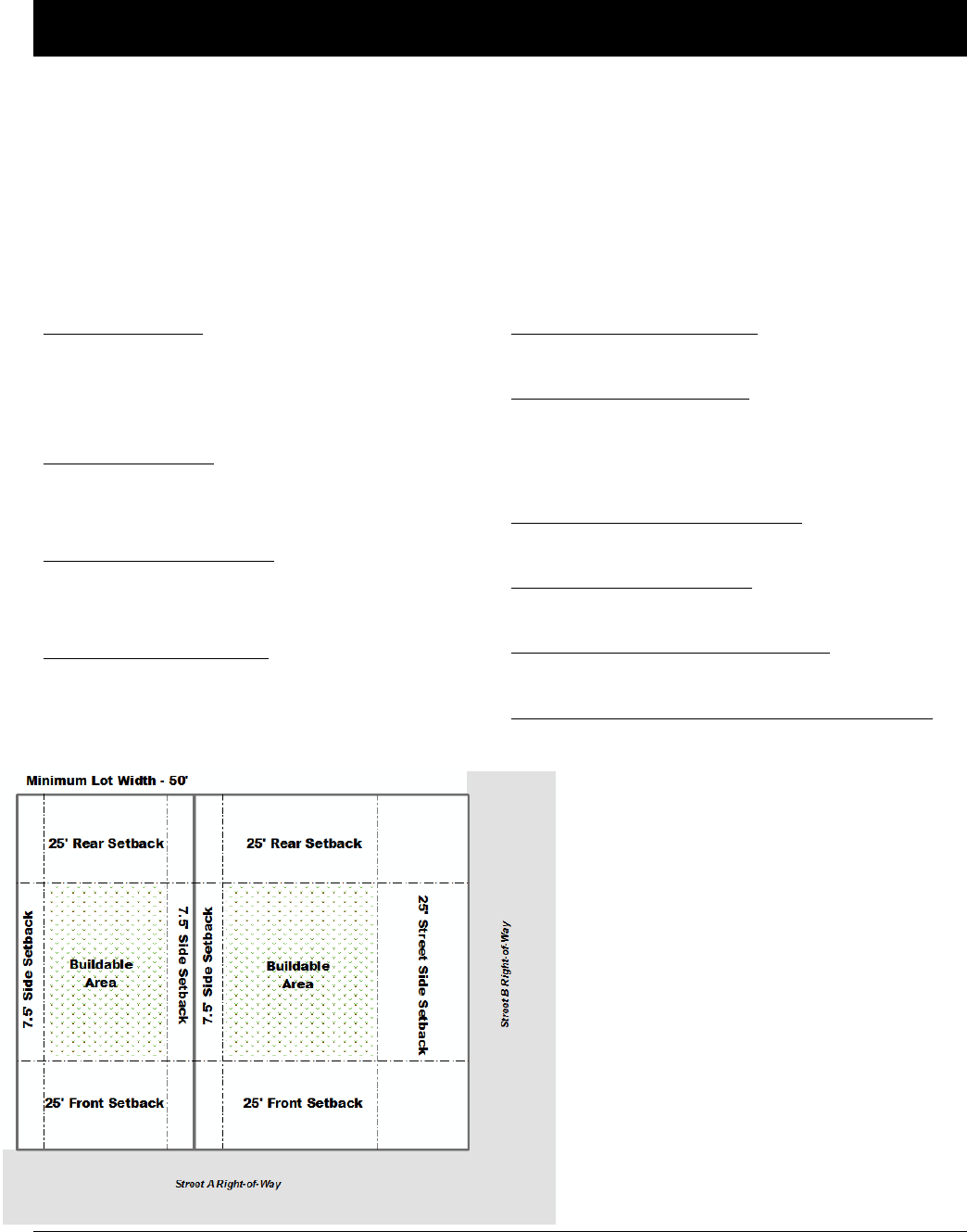
Oldham County Comprehensive Zoning Ordinance
Division 120 O-1 Office District
31
DIVISION 120 O-1 OFFICE DISTRICT
Sec. 120-010 O-1 Office District: Intent
The purpose of the O-1 Office District is to provide locations for low density Professional Offices in relative
proximity to residential districts. This district may serve as a reasonable transition between commercial districts
and neighborhood residential areas. It is intended that any development in an O-1 district be designed, built, and
maintained so that it will be compatible with the character of the nearby residential neighborhoods and does not
create or generate an excessive amount of traffic and/or noise.
Sec. 120-020 O-1 Office District: Development Regulations
Minimum Lot Area:
5,000 square feet with sanitary sewers
43,560 square feet without sanitary sewers
43,560 square feet within the city of Pewee Valley
Minimum Lot Width:
50 feet; or
150 feet without sanitary sewers
Maximum Density/Intensity:
6 dwelling units per acre
1.0 Floor Area Ratio
Maximum Structure Height:
45 feet (agriculture structures are exempt)
Minimum Front Yard Setback:
25 feet
Minimum Side Yard Setback:
7.5 feet plus 3 feet for each story over three
15 feet plus 6 feet for each story over three for total
for both sides.
Minimum Street Side Yard Setback:
25 feet plus 3 feet for each story over three
Minimum Rear Yard Setback:
25 feet
Maximum Lot Coverage for Structures:
65 percent of the lot area
Maximum Impervious Surface Including Structures:
80 percent of the lot area
Additional Standards that may Apply:
Accessory Dwelling Units.…Sec 250-040
Accessory Uses & Struc.……Sec 250-030
Agritourism Buildings……….Sec 260-035
Barrel Warehouses……….....Sec 250-320
Brew pubs………………………..Sec 250-310
Distillery & Brewery………….Sec 250-300
Height………………………………Sec 330-010
Home Occupation…….…..….Sec 260-230
Fences & Walls…………….…..Sec 250-090
Capacity of Infrastructure…Division 270
Highway 53 Overlay Dist. ….Division245
Historic Preservation…………Division 240
Landscaping………………………Division 300
Lighting……………………………..Division 310
Parking………………………………Division 280
Signs……………………….…………Division 290

Oldham County Comprehensive Zoning Ordinance
Division 120 O-1 Office District
32
Sec. 120-030 O-1 Office District:
Permitted Uses
Sec. 120-040 O-1 Office District:
Conditional Uses
Agricultural Uses
Agricultural Uses
Community Facilities
Colleges and Schoos, not for profit (CF)
Private Clubs
Public and Governmental Buildings and Facilities
Office
Business and Professional Offices with a gross floor area
< 5,000 square feet
Medical Office/Clinic with a gross floor area < 5,000
square feet
Public Parks and Recreation
Public Parks
Public Picnic Grounds, Beaches, Bridle and Bicycle
Paths
Religious Institutions
Churches and other Religious Institutions
Residential
Dwellings – Single-Family Detached
Dwellings – Two-Family
Residential Care Facility
Special
Lakes (man-made) non-commercial
Commercial
Veterinary Hospitals and Kennels
Community Facilities and Services
Nursery Schools, Day Nurseries, and Child Care Centers
Health Services
Hospitals and Institutions
Natural Resource
Borrow Pits, Quarry, Gravel Pit or Stone Mill
Extraction and Development of Natural Resources
Recreation
Aviaries and Zoos
Special
Airports, Heliports, and other Airship or Flying Machine
Take-Off or Landing Facilities
Cemeteries, Mausoleums and Crematories
Commercial Lakes
Utilities
Private Utility Buildings and Facilities
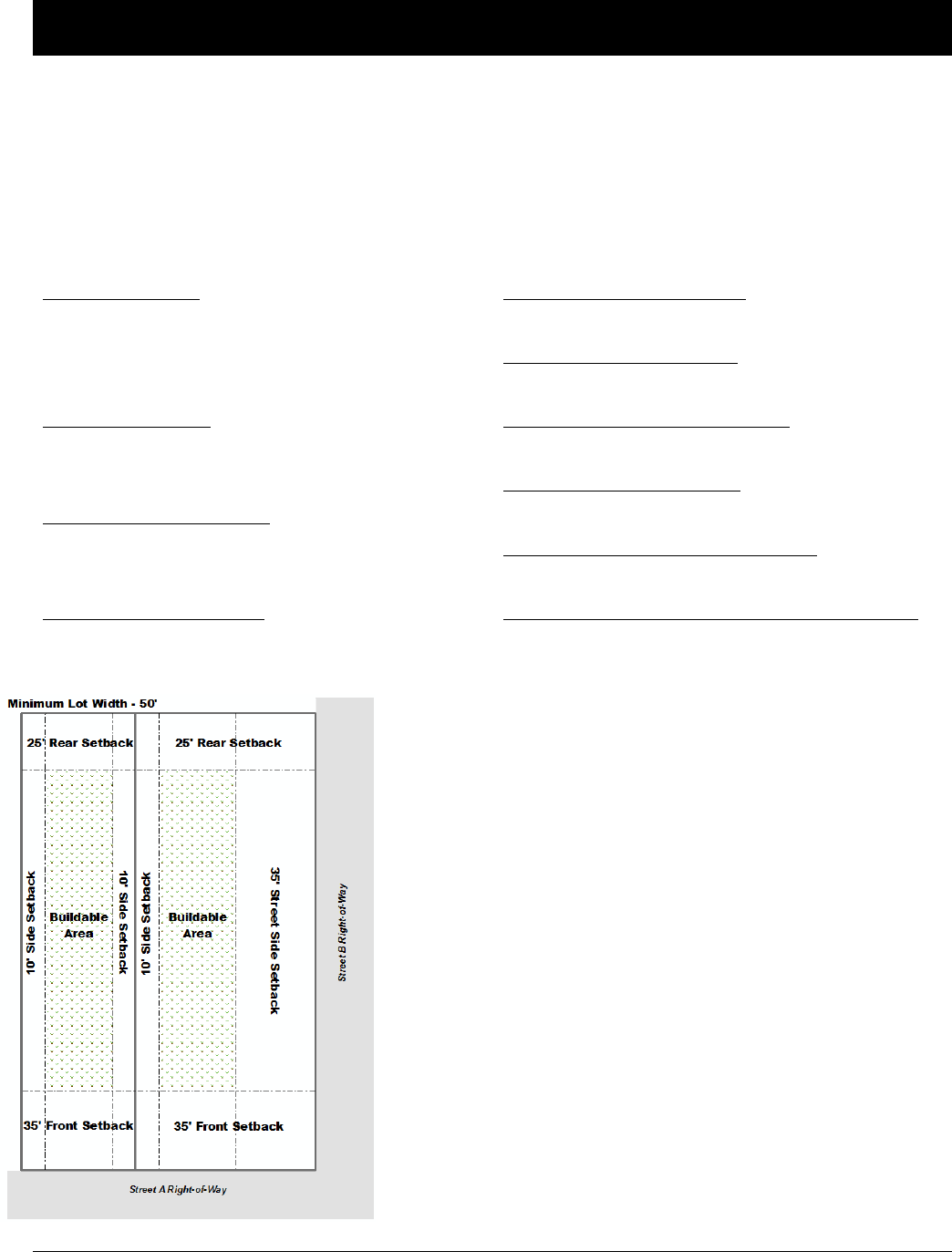
Oldham County Comprehensive Zoning Ordinance
Division 130 O-2 Office District
33
DIVISION 130 O-2 OFFICE DISTRICT
Sec. 130-010 O-2 Office District: Intent
The purpose of the O-2 Office District is to provide locations for medium-intensity business and Professional
Offices and related uses. It is intended that any development in an O-2 Office District be designed, built, and
maintained so that it will be compatible with the character of nearby residential neighborhoods and does not create
or generate an excessive amount of traffic or noise.
Sec. 130-020 O-2 Office District: Development Regulations
Minimum Lot Area:
10,000 square feet with sanitary sewers
43,560 square feet without sanitary sewers
43,560 square feet within the city of Pewee Valley
Minimum Lot Width:
50 feet; or
150 feet without sanitary sewers
Maximum Density/Intensity:
16 dwelling units per acre
3.0 Floor Area Ratio
Maximum Structure Height:
45 feet (agriculture structures are exempt)
Minimum Front Yard Setback:
35 feet
Minimum Side Yard Setback:
10 feet
Minimum Street Side Yard Setback:
35 feet
Minimum Rear Yard Setback:
25 feet
Maximum Lot Coverage for Structures:
65 percent of the lot area
Maximum Impervious Surface Including Structures:
85 percent of the lot area
Additional Standards that may Apply:
Accessory Dwelling Units.…Sec 250-040
Accessory Uses & Struc.……Sec 250-030
Agritourism Buildings……….Sec 260-035
Barrel Warehouses……….....Sec 250-320
Brew pubs………………………..Sec 250-310
Distillery & Brewery………….Sec 250-300
Height………………………………Sec 330-010
Home Occupation…….…..….Sec 260-230
Fences & Walls…………….…..Sec 250-090
Capacity of Infrastructure…Division 270
Highway 53 Overlay Dist. ….Division245
Historic Preservation…………Division 240
Landscaping………………………Division 300
Lighting……………………………..Division 310
Parking………………………………Division 280
Signs……………………….…………Division 290

Oldham County Comprehensive Zoning Ordinance
Division 130 O-2 Office District
34
Sec. 130-030 O-2 Office District:
Permitted Uses
Sec. 130-040 O-2 Office District:
Conditional Uses
Agricultural Uses
Agricultural Uses
Commercial
Funeral Homes and Mortuaries
Community Facilities
Colleges and Schools, not for profit (CF)
Adult Day Centers
Nursery Schools, Day Nurseries, and Child Care Centers
Office
Business and Professional Offices
Medical Office/Clinics
Outdoor Recreation
Private Country Clubs, Golf Courses except Miniature
Courses or Comercial Driving Ranges
Public Parks and Recreation
Boat Docks and Launching Areas,
Recreational Camps, Resorts
Public Parks and Forest Preserves
Public Picnic Grounds, Beaches, Bridle and Bicycle
Paths
Religious Institutions
Churchs and Other Religious Institutions
Residential
Dwellings – Single-Family Detached
Dwellings – Two-Family
Residential Care Facility
Special
Lakes (man-made) non-commercial
Private Clubs
Utilities
Public Utility Buildings and Facilities
Commercial
Veterinary Hospitals and Kennels
Funeral Homes and Mortuaries
Health Services
Hospitals and Institutions
Natural Resource
Borrow Pits, Quarry, Gravel Pit, or Stone Mill
Extraction and Development of Natural Resources
Special
Airports, Heliports, and other Airship or Flying Machine
Take-off of Landing Facilities
Cemeteries, Mausoleums and Crematories
Commercial Lakes
Utilities
Private Utility Buildings and Facilities
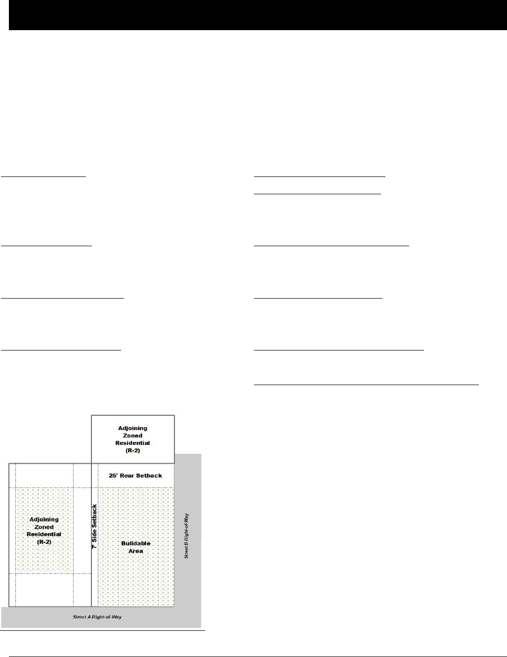
Oldham County Comprehensive Zoning Ordinance
Division 140 C-N Commercial Neighborhood District
35
DIVISION 140 C-N COMMERCIAL NEIGHBORHOOD DISTRICT
Sec. 140-010 Commercial Neighborhood District: Intent
The purpose of the C-N Commercial Neighborhood District is to promote the reuse of structures located in urban
areas of Oldham County that have been constructed for mixed commercial and residential use, which may be
currently under used or vacant, and which are located at street corners or on blocks with a significant number of
retail business uses. C-N zoning may also be appropriate for new construction where a mixture of business and
residential use is found to conform with the Comprehensive Plan and to any Master Plan covering that area.
Sec. 140-020 C-N Commercial Neighborhood District: Development Regulations
Minimum Lot Area:
5,000 square feet with sanitary sewers
43,560 square feet without sanitary sewers
43,560 square feet within the city of Pewee Valley
Minimum Lot Width:
50 feet; or
150 feet without sanitary sewers
Maximum Density/Intensity:
16 dwelling units per acre
2.0 Floor Area Ratio
Maximum Structure Height:
45 feet (agriculture structures are exempt)
Minimum Front Yard Setback: None
Minimum Side Yard Setback:
None except when abutting a residential district
(shall take on that of the abutting district)
Minimum Street Side Yard Setback:
None except when abutting a residential district
(shall take on that of the abutting district)
Minimum Rear Yard Setback:
None except when abutting a residential district
(shall take on that of the abutting district)
Maximum Lot Coverage for Structures:
65 percent of the lot area
Maximum Impervious Surface Including Structures:
85 percent of the lot area
Additional Standards Apply

Oldham County Comprehensive Zoning Ordinance
Division 140 C-N Commercial Neighborhood District
36
Sec. 140-030 C-N Commercial Neighborhood
District: Permitted Uses
Sec. 140-040 C-N Commercial Neighborhood:
Conditional Uses
Agricultural Uses
Agricultural Uses
Farmers Markets
Eating Establishments
Restaurants without drive-thru facilities
Commercial
Retail and Personal Service Establishments with a gross
floor area < 10,000 square feet
Community Facilities
Colleges and Schools, not for profit (CF)
Libraries, Museums, and Art Galleries
Parks, Playgrounds, Community Centers, and Similar
Uses (CF)
Office
Business and Professional Offices not including Clinics
and Immediate Care Facilities
Public Parks and Recreation
Public Parks and Forest Preserves
Public Picnic Grounds and Bicycle Paths
Religious Institutions
Churches and other Religious Institutions
Residential
Dwellings – Single-Family Detatched
Dwellings – Two-Family
Dwellings – Multi-Family
Residential Care Facility
Special
Bed and Breakfasts
Lakes (man-made) non-commercial
Utilties
Public Utility Buildings and Facilities
Commercial
Veterinary Hospitals and Kennels
Private Clubs
Community Facilities and Services
Community Buildings and Facilities
Marinas or Boat Rental
Nursery Schools, Day Nurseries, and Child Care Centers
Health Services
Hospitals and Institutions
Residential
Manufactured Homes
Utilities
Private Utility Buildings and Facilities
Sewage Treatment Plants
Additional Standards that may Apply:
Accessory Dwelling Units.…Sec 250-040
Accessory Uses & Struc.……Sec 250-030
Agritourism Buildings……….Sec 260-035
Barrel Warehouses……….....Sec 250-320
Brew pubs………………………..Sec 250-310
Distillery & Brewery………….Sec 250-300
Height………………………………Sec 330-010
Home Occupation…….…..….Sec 260-230
Fences & Walls…………….…..Sec 250-090
Capacity of Infrastructure…Division 270
Highway 53 Overlay Dist. ….Division245
Historic Preservation…………Division 240
Landscaping………………………Division 300
Lighting……………………………..Division 310
Parking………………………………Division 280
Signs……………………….…………Division 290
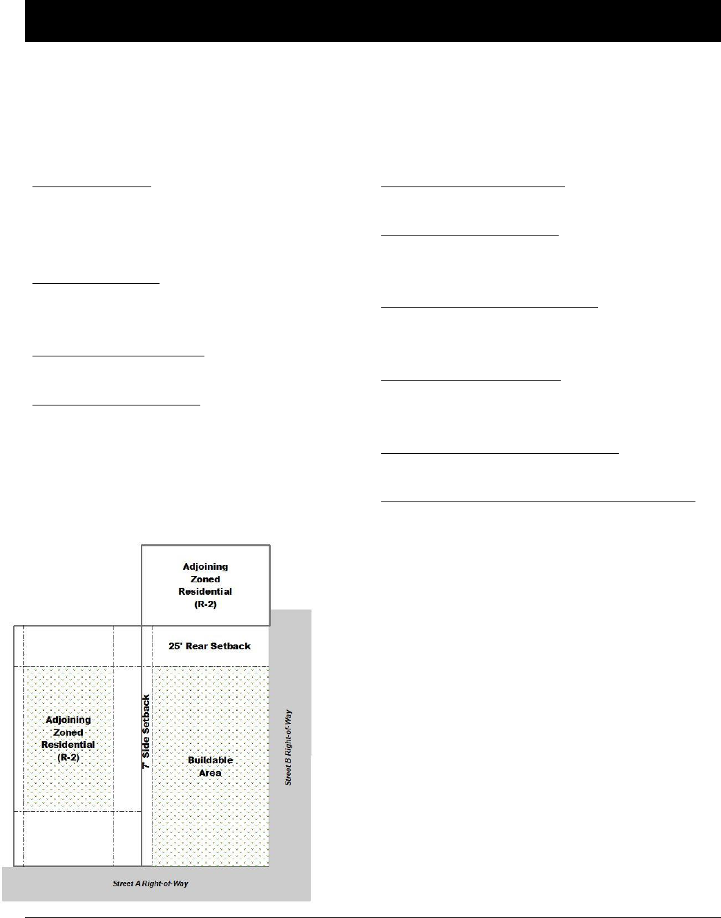
Oldham County Comprehensive Zoning Ordinance
Division 150 C-1 Local Business District
37
DIVISION 150 C-1 LOCAL BUSINESS DISTRICT
Sec. 150-010 C-1 Local Business District: Intent
The purpose of the C-1 Local Business District is to provide primarily for retail shopping and personal service uses
to be developed either as a unit or in individual parcels to serve the needs of nearby residential neighborhoods.
Sec. 150-020 C-1 Local Business District: Development Regulations
Minimum Lot Area:
7,500 square feet with sanitary sewers
43,560 square feet without sanitary sewers
43,560 square feet within the city of Pewee Valley
Minimum Lot Width:
50 feet; or
150 feet without sanitary sewers
Maximum Density/Intensity:
0.5 Floor Area Ratio
Maximum Structure Height:
45 feet (agriculture structures are exempt)
Minimum Front Yard Setback:
None
Minimum Side Yard Setback:
None except when abutting a residential district
(shall take on that of the abutting district)
Minimum Street Side Yard Setback:
None except when abutting a residential district
(shall take on that of the abutting district)
Minimum Rear Yard Setback:
None except when abutting a residential district
(shall take on that of the abutting district)
Maximum Lot Coverage for Structures:
40 percent of the lot area
Maximum Impervious Surface Including Structures:
65 percent of the lot area
Additional Standards that may Apply:
Accessory Dwelling Units.…Sec 250-040
Accessory Uses & Struc.……Sec 250-030
Agritourism Buildings……….Sec 260-035
Barrel Warehouses……….....Sec 250-320
Brew pubs………………………..Sec 250-310
Distillery & Brewery………….Sec 250-300
Height………………………………Sec 330-010
Home Occupation…….…..….Sec 260-230
Fences & Walls…………….…..Sec 250-090
Capacity of Infrastructure…Division 270
Highway 53 Overlay Dist. ….Division245
Historic Preservation…………Division 240
Landscaping………………………Division 300
Lighting……………………………..Division 310
Parking………………………………Division 280
Signs……………………….…………Division 290

Oldham County Comprehensive Zoning Ordinance
Division 150 C-1 Local Business District
38
Sec. 150-030 C-1 Local Business District:
Permitted Uses
Sec. 150-040 C-1 Local Business District:
Conditional Uses
Agricultural Uses
Agricultural Uses
Farmers Market
Riding Academies and Stables
Commercial
Adult Entertainment Establishments
Firework Sales (Permanent, Ancillary and Seasonal)
Retail and Personal Service Establishments with a gross
floor area < 50,000 swuare feet
Community Facilities
Adult Day Centers
Colleges and Schools, not for profit (CF)
Nursery Schools, Day Nurseries, and Child Care Centers
Parks, Playgrounds, Community Centers and smiliar uses
Eating Establishments
Restaurants without drive-thru facilities
Office
Business and Professional Offices not including Clinics
and Immediate Care Facilities
Public Parks and Recreation
Public Parks and Forest Preserves
Public Picnic Grounds, Beaches, Bridle and Bicycle
Paths
Religious Institutions
Churches and other Religious Institutions
Special
Lakes (man-made) non-commercial
Utlities
Public Utility Buildings and Facilities
Commercial
Veterinary Hospitals and Kennels
Community Facilities and Services
Marinas or Boat Rental
Public and Governmental Buidlings and Facilities
Health Services
Hospitals and Instituions
Natural Resource
Borrow Pits, Quarry, Gravel Pit, or Stone Mill
Extraction and Development of Natural Resources
Recreation
Aviaries and Zoos
Private Clubs and Country Clubs, Gold Courses except
Commercial Driving Ranges
Special
Airports, Heliports, and other Airship or Flying Machine
Take-off or Landing Facilities
Cememteries, Mausoleums and Crematories
Commercial Lakes
Utiltites
Private Utility Buidlings and Facilities
Sewage Treatment Plants

Oldham County Comprehensive Zoning Ordinance
Division 170 C-3 General Business District
39
DIVISION 160 C-2 COMMUNITY BUSINESS DISTRICT
Sec. 160-010 C-2 Community Business District: Intent
The purpose of the C-2 Community Business District is to provide for retail shopping and personal service uses,
shopping goods and household services for a population considerably larger than that served by local business
districts.
Sec. 160-020 C-2 Community Business District: Development Regulations
Minimum Lot Area:
6,000 square feet with sanitary sewers
43,560 square feet without sanitary sewers
43,560 square feet within the city of Pewee Valley
Minimum Lot Width:
50 feet; or
150 feet without sanitary sewers
Maximum Density/Intensity:
1.0 Floor Area Ratio
Maximum Structure Height:
45 feet (agriculture structures are exempt)
Minimum Front Yard Setback:
None
Minimum Side Yard Setback:
None except when abutting a residential district
(shall take on that of the abutting district)
Minimum Street Side Yard Setback:
None except when abutting a residential district
(shall take on that of the abutting district)
Minimum Rear Yard Setback:
None except when abutting a residential district
(shall take on that of the abutting district)
Maximum Lot Coverage for Structures:
40 percent of the lot area
Maximum Impervious Surface Including Structures:
65 percent of the lot area
Additional Standards that may Apply:
Accessory Dwelling Units.…Sec 250-040
Accessory Uses & Struc.……Sec 250-030
Agritourism Buildings……….Sec 260-035
Barrel Warehouses……….....Sec 250-320
Brew pubs………………………..Sec 250-310
Distillery & Brewery………….Sec 250-300
Height………………………………Sec 330-010
Home Occupation…….…..….Sec 260-230
Fences & Walls…………….…..Sec 250-090
Capacity of Infrastructure…Division 270
Highway 53 Overlay Dist. ….Division245
Historic Preservation…………Division 240
Landscaping………………………Division 300
Lighting……………………………..Division 310
Parking………………………………Division 280
Signs……………………….…………Division 290

Oldham County Comprehensive Zoning Ordinance
Division 170 C-3 General Business District
40
Sec. 160-030 C-2 Community Business
District: Permitted Uses
Sec. 160-040 C-2 Community Business
District: Conditional Uses
Agricultural Uses
Agricultural Uses
Farmers Market
Riding Academies and Stables
Commercial
Adult Entertaionment Establishments
Firework Sales (Permanent, Ancillary and Seasonal)
Funeral Homes and Mortuaries
Hotels and Motels
Nursing Homes
Retail and Personal Establishments with a gross floor
area < 50,000 square feet
Vehicle Repair including service stations
Vehicle Washes
Vocational Schools
Community Facilities
Adult Day Centers
Colleges and Schools, not for profit (CF)
Nursery Schools, Day Nurseries, and Child Care Centers
Parks, Playgrounds, Community Centers, and Similar
Uses
Eating Establishments
Restaurants with drive-thru facilities
Indoor Recreation
Movie Theatres
Office
Business and Professional Offices including Clinics and
Immediate Care Facilities
Public Parks and Recreation
Boat Docks and Launching Areas, Recreational Camps,
Resorts
Public Parks and Forest Preserves
Public Picnic Grounds, Bridle and Bicycle Paths
Religious Institutions
Churches and other Religious Institutions
Special
Lakes (man-made) non-commercial
Utilities
Public Utility Buildings and Facilities
Commercial
Veterinary Hospitals and Kennels
Community Facilities and Services
Marinas or Boat Renal
Health Services
Hospitals and Institutions
Natural Resource
Borrow Pits, Quarry, Gravel Pit, or Stone Mill
Extraction and Development of Natural Resources
Recreation
Aviaries and Zoos
Indoor Sports Facilities
Private Clubs, Country Clubs, Golf Courses except
Miniature cources or Commercial Driving Ranges
Residential
Community Residences
Special
Airports, Heliports and other Airshp or Flying Machine
Take-off or Landing Facilities
Cemeteries, Mausoleums and Crematories
Commercial Lakes
Utilities
Private Utility Buildings and Facilities
Sewage Treatment Plants
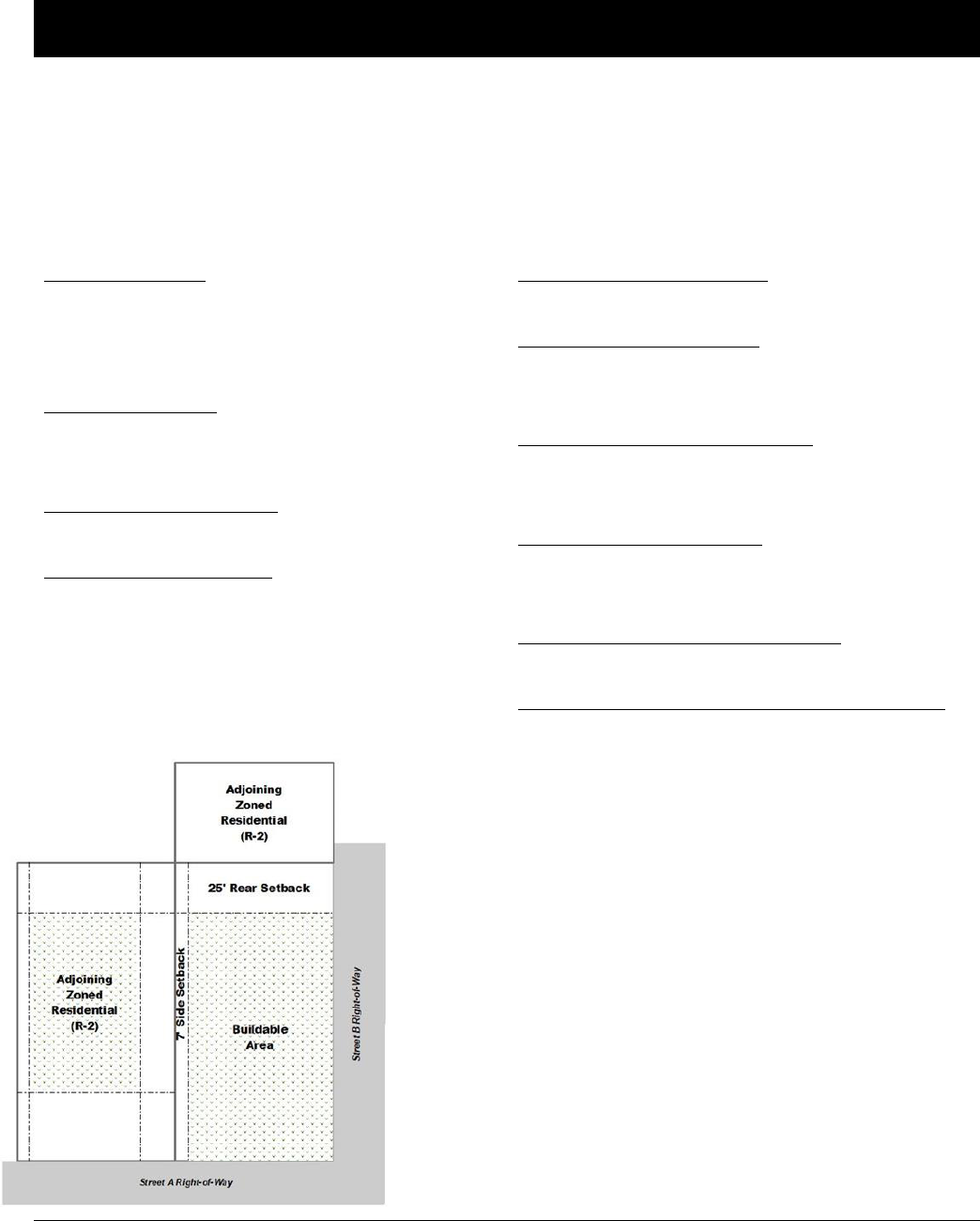
Oldham County Comprehensive Zoning Ordinance
Division 170 C-3 General Business District
41
DIVISION 170 C-3 GENERAL BUSINESS DISTRICT
Sec. 170-010 C-3 General Business District: Intent
The purpose of the C-3 General Business District is to provide for appropriate locations for a wide variety of
businesses, commercial, mass merchant and miscellaneous service activities, but does not include land uses
characterized by extensive warehousing or frequent heavy trucking activity.
Sec. 170-020 C-3 General Business District: Development Regulations
Minimum Lot Area:
6,000 square feet with sanitary sewers
43,560 square feet without sanitary sewers
43,560 square feet within the city of Pewee Valley
Minimum Lot Width:
50 feet; or
150 feet without sanitary sewers
Maximum Density/Intensity:
1.0 Floor Area Ratio
Maximum Structure Height:
45 feet (agriculture structures are exempt)
Minimum Front Yard Setback:
None
Minimum Side Yard Setback:
None except when abutting a residential district
(shall take on that of the abutting district)
Minimum Street Side Yard Setback:
None except when abutting a residential district
(shall take on that of the abutting district)
Minimum Rear Yard Setback:
None except when abutting a residential district
(shall take on that of the abutting district)
Maximum Lot Coverage for Structures:
40 percent of the lot area
Maximum Impervious Surface Including Structures:
65 percent of the lot area
Additional Standards that may Apply:
Accessory Dwelling Units.…Sec 250-040
Accessory Uses & Struc.……Sec 250-030
Agritourism Buildings……….Sec 260-035
Barrel Warehouses……….....Sec 250-320
Brew pubs………………………..Sec 250-310
Distillery & Brewery………….Sec 250-300
Height………………………………Sec 330-010
Home Occupation…….…..….Sec 260-230
Fences & Walls…………….…..Sec 250-090
Capacity of Infrastructure…Division 270
Highway 53 Overlay Dist. ….Division245
Historic Preservation…………Division 240
Landscaping………………………Division 300
Lighting……………………………..Division 310
Parking………………………………Division 280
Signs……………………….…………Division 290

Oldham County Comprehensive Zoning Ordinance
Division 170 C-3 General Business District
42
Sec. 170-030 C-3 General Business District:
Permitted Uses
Sec. 170-040 General Business District:
Conditional Uses
Agricultural Uses
Agricultural Uses
Farmers Market
Riding Academies and Stables
Commercial
Adult Entertainment Establishments
Building Material Sales
Firework Sales (Permanent, Ancillary, and Seasonal)
Funeral Homes and Mortuaries
Hotels and Motels
Nursing Homes
Printing and Lithograph Shops
Retail and Personal Services Establishments with a gross
floor area < 100,000 square feet
Vehicle Repair including service stations
Vehicle Sales and Display
Vehicle Wash
Vocational Schools
Community Facilities
Adult Day Centers
Colleges and Schools, not for profit (CF)
Nursery Schools and Childcare Centers
Parks, Playgrounds, Community Centers, and Similar
Uses
Public and Government Buildings and Facilities
Eating Establishments
Eating Establishments of any kind
Light Industrial
Boat and Marine Supplies
Building and Related Trades Shops
Lumber Storage, Millwork, and Sales
Storage Facilities for Frozen Products
Office
Business and Professional Offices including Clinics and
Immediate Care Facilities
Public Parks and Recreation
Boat Docks and Launching Areas, Recreational Camps,
Resorts Public Parks and Forest Preserves
Commercial
Auto Auctions
Veterinary Hospitals and Kennels
Community Facilities and Services
Marinas or Boat Rental
Health Services
Hospitals and Institutions
Light Industrial
Contractor’s Equipment Storage
Grain and Feed Storage and Sales
Mini-Warehouses/Self Storage Facilities
Natural Resource
Borrow Pits, Quarry, Gravel Pit, or Stone Mill
Extraction and Development of Natural
Resources,
Recreation
Aviaries and Zoos
Indoor Sports Facilities
Residential
Community Residences
Special
Airports, Heliports, and other Airship or Flying Machine
Take-off or Landing
Facilities
Cemeteries, Mausoleums and Crematories
Commercial Lakes
Utilities
Private Utility Buildings and Facilities
Sewage Treatment Plants

Oldham County Comprehensive Zoning Ordinance
Division 170 C-3 General Business District
43
Public Picnic Grounds, Beaches, Bridle and Bicycle
Paths
Recreation
Indoor Movie Theatres
Private Country Clubs, Golf Courses
Miniature Golf Courses
Commercial Driving Ranges
Religious Institutions
Churches and other Religious Institutions
Special
Lakes (man-made) non-commercial
Utilities
Public Utility Buildings and Facilities
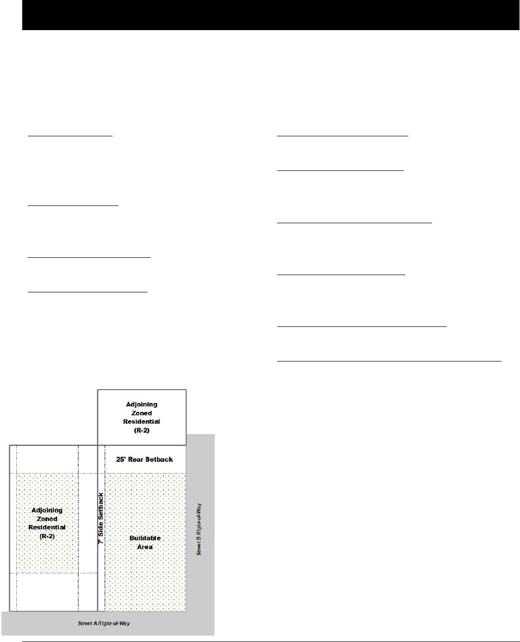
Oldham County Comprehensive Zoning Ordinance
Division 180 C-4 Highway Service District
44
DIVISION 180 C-4 HIGHWAY SERVICE DISTRICT
Sec. 180-010 C-4 Highway Service District: Intent
The purpose of the C-4 Highway Service District is to provide for suitable locations for general
commercial businesses that require heavy infrastructure.
Sec. 180-020 C-4 Highway Service District: Development Regulations
Minimum Lot Area:
5,000 square feet with sanitary sewers
43,560 square feet without sanitary sewers
43,560 square feet within the city of Pewee Valley
Minimum Lot Width:
50 feet; or
150 feet without sanitary sewers
Maximum Density/Intensity:
2.0 Floor Area Ratio
Maximum Structure Height:
45 feet (agriculture structures are exempt)
Minimum Front Yard Setback:
None
Minimum Side Yard Setback:
None except when abutting a residential district
(shall take on that of the abutting district)
Minimum Street Side Yard Setback:
None except when abutting a residential district
(shall take on that of the abutting district)
Minimum Rear Yard Setback:
None except when abutting a residential district
(shall take on that of the abutting district)
Maximum Lot Coverage for Structures:
40 percent of the lot area
Maximum Impervious Surface Including Structures:
65 percent of the lot area
Additional Standards that may Apply:
Accessory Dwelling Units.…Sec 250-040
Accessory Uses & Struc.……Sec 250-030
Agritourism Buildings……….Sec 260-035
Barrel Warehouses……….....Sec 250-320
Brew pubs………………………..Sec 250-310
Distillery & Brewery………….Sec 250-300
Height………………………………Sec 330-010
Home Occupation…….…..….Sec 260-230
Fences & Walls…………….…..Sec 250-090
Capacity of Infrastructure…Division 270
Highway 53 Overlay Dist. ….Division245
Historic Preservation…………Division 240
Landscaping………………………Division 300
Lighting……………………………..Division 310
Parking………………………………Division 280
Signs……………………….…………Division 290

Oldham County Comprehensive Zoning Ordinance
Division 180 C-4 Highway Service District
45
Sec. 180-030 C-4 Highway Service District:
Permitted Uses
Sec. 180-040 C-4 Highway Service District:
Conditional Uses
Agricultural Uses
Agricultural Uses including Farmers Market
Riding Academies and Stables
Commercial
Adult Entertainment Establishments
Building Material Sales
Firework Sales (Permanent, Ancillary and Seasonal)
Funeral Homes and Mortuaries
Hotels and Motels
Nursing Homes
Printing and Lithograph Shops
Retail and Personal Service Establishments
Vehicle Sales and Display
Vehicular Service & Repair Stations
Vehicle Wash Vocational Schools
Community Facilities
Adult Day Centers
Colleges and Schools, Not For Profit (CF)
Nursery Schools, Day Nurseries, and Child Care Centers
Parks, Playgrounds, Community Centers, and Similar Uses
Eating Establishments
Eating Establishments of Any Kind
Light Industrial
Boat and Marine Supplies
Building and Related Trades Shops
Lumber Storage, Millwork, and Sales
Manufactured Home Sales and Service
Storage Facilities for Frozen Products
Office
Business and Professional Offices Including Clinics and
Immediate Care Facilities
Recreation
Boat Docks,Launching Areas, Recreational Camps, Resorts
Indoor Movie Theatres
Private Clubs, Golf Courses, Miniature Golf Courses or Driving
Ranges
Public Parks and Forest Preserves
Public Picnic Grounds, Beaches, Bridle and Bicycle Paths
Commercial
Auto Auctions
Veterinary Hospitals and Kennels
Community Facilities and Services
Marinas or Boat Rental
Health Services
Hospitals and Institutions
Light Industrial
Carting and Express Hauling Establishments
Contractor’s Equipment Storage
Grain and Feed Storage and Sales
Mini-Warehouses/Self Storage Facilities
Natural Resource
Borrow Pits, Quarry, Gravel Pit, or Stone Mill
Extraction and Development of Natural Resources
Recreation
Aviaries and Zoos
Indoor Sports Facilities
Residential
Community Residences
Special
Airports, Heliports, and Other Airship or Flying
Machine Take-Off or Landing Facilities
Cemeteries, Mausoleums and Crematories
Utilities
Private Utility Building and Facilities
Sewage Treatment Plants

Oldham County Comprehensive Zoning Ordinance
Division 180 C-4 Highway Service District
46
Religious Institutions
Churches and Other Religious Institutions
Utilities
Public Utility Buildings and Facilities
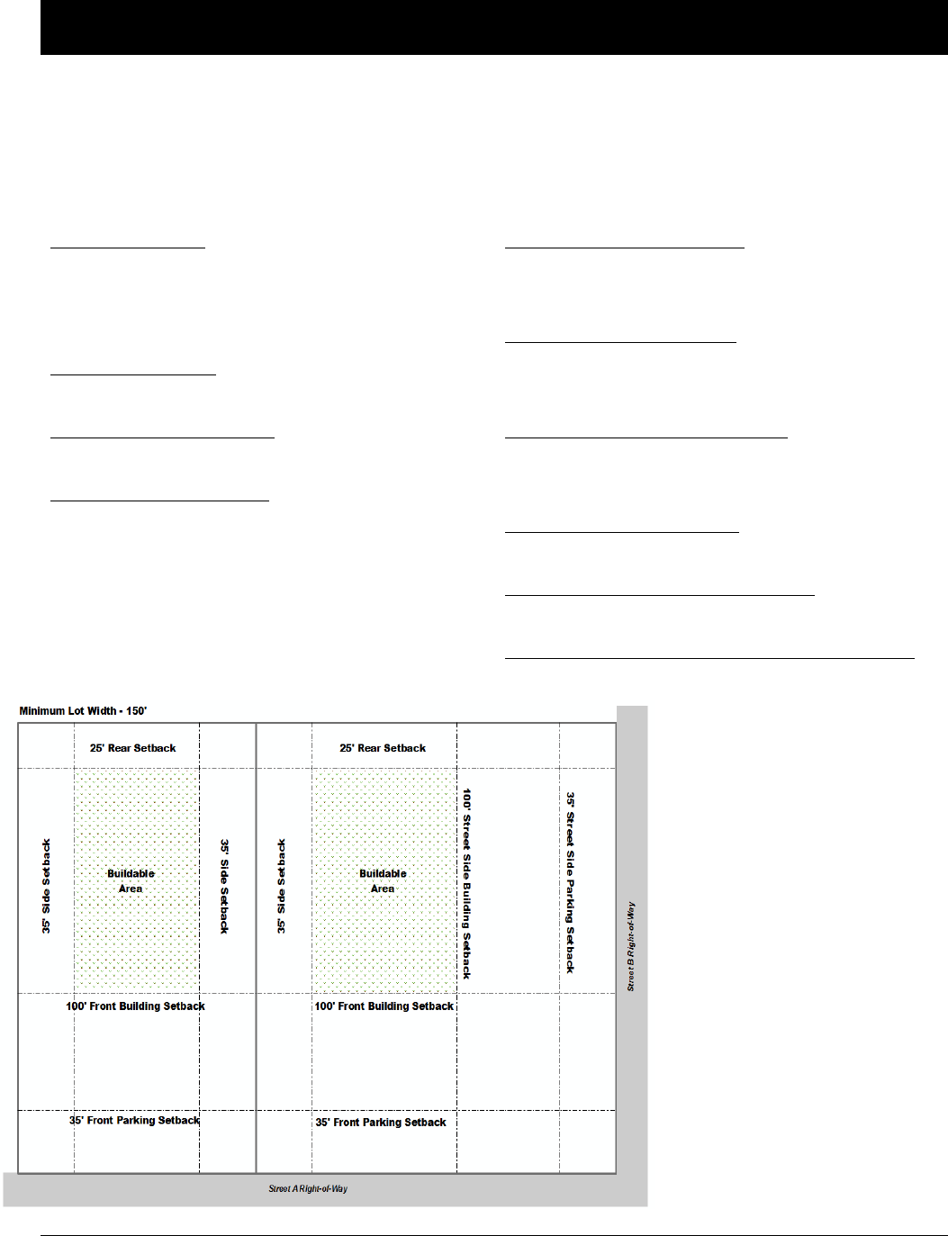
Oldham County Comprehensive Zoning Ordinance
Division 200 I-2 Heavy Industrial District
47
DIVISION 190 I-1 LIGHT INDUSTRIAL DISTRICT
Sec. 190-010 I-1 Light Industrial District: Intent
The purpose of the I-1 Light Industrial District is to provide for commercial use, storage and any
manufacturing use not normally crating a nuisance discernible beyond its property.
Sec. 190-020 I-1 Light Industrial District: Development Regulations
Minimum Lot Area:
10,000 square feet with sanitary sewers
43,560 square feet without sanitary sewers
43,560 square feet within the city of Pewee Valley
Minimum Lot Width:
150 feet
Maximum Density/Intensity:
1.0 Floor Area Ratio
Maximum Structure Height:
50 feet (agriculture structures are exempt)
Minimum Front Yard Setback:
100 feet for structures
35 feet for parking areas
Minimum Side Yard Setback:
35 feet; or
75 feet required when abutting a residential district
Minimum Street Side Yard Setback:
100 feet for structures
35 feet for parking areas
Minimum Rear Yard Setback:
25 feet
Maximum Lot Coverage for Structures:
75 percent of the lot area
Maximum Impervious Surface Including Structures:
90 percent of the lot area
Additional Standards that may Apply:
Accessory Dwelling Units.…Sec 250-040
Accessory Uses & Struc.……Sec 250-030
Agritourism Buildings……….Sec 260-035
Barrel Warehouses……….....Sec 250-320
Brew pubs………………………..Sec 250-310
Distillery & Brewery………….Sec 250-300
Height………………………………Sec 330-010
Home Occupation…….…..….Sec 260-230
Fences & Walls…………….…..Sec 250-090
Capacity of Infrastructure…Division 270
Highway 53 Overlay Dist. ….Division245
Historic Preservation…………Division 240
Landscaping………………………Division 300
Lighting……………………………..Division 310
Parking………………………………Division 280
Signs……………………….…………Division 290

Oldham County Comprehensive Zoning Ordinance
Division 200 I-2 Heavy Industrial District
48
Sec. 190-030 I-1 Light Industrial District:
Permitted Uses
Sec. 190-040 I-1 Light Industrial District:
Conditional Uses
Agricultural Uses
Agricultural Uses
Riding Academies and Stables
Community Facilities
Nursery Schools, Day Nurseries, and
Child Care Centers
Schools, Parks, Playgrounds, Community Centers, and Similar Uses
Commercial
Adult Entertainment Establishments
Art Studios
Colleges and Schools, not for profit (CF)
Funeral Homes and Mortuaries
Household Services
Retail and Personal Service Establishments
Vehicular Repair of any kind
Veterinary Hospitals and Kennels
Vocational Schools
Eating Establishments
Eating Establishments of any kind
Light Industrial
Aircraft Factory or Hangar, not including wind tunnel and testing
field
Blacksmith Shop or Horse ShoeingEstablishment
Boat and Marine Supplies
Boat Building
Bottlers, Breweries, Distilleries, and Wineries
Box Factory
Lumber Storage, Millwork, and Sales Mini-Warehouses/Self Storage
Facilities
Public Parks and Recreation
Boat Docks and Launching Areas
Recreational Camps, Resorts
Indoor Sports Facilities
Public Parks and Forest Preserves
Public picnic grounds, beaches, bridle and bicycle paths
Religious Institutions
Churches and other Religious Institutions
Utilities
Public Utility Buildings and Facilities
Community Facilities and Services
Marinas or Boat Rental
Recreational Vehicle Parks and Campgrounds
Health Services
Hospitals and Institutions
Heavy Industrial
Asphalt Processing
Concrete, Central Mixing and Batching Plant
Fertilizer, Incineration, or Reduction Products
Freight Terminals/Similar Enterprises
Slaughter Houses
Recreation
Amusement Parks, Circus and Carnival Grounds
Aviaries and Zoos
Commercial Rifle, Pistol and Skeet Ranges
(Indoor and Outdoor)
Drive-In Theatres
Private Clubs, country clubs, golf courses except
Miniature Courses or Commercial Driving
Ranges
Special
Airports, Heliports and Other Airship or Flying
Machine Take-off or Landing Facilities
Borrow Pits, Quarry, Gravel Pit, or Stone Mill
Cemeteries, Mausoleums and Crematories
Commercial Lakes
Extraction and Development of Natural Resources
Utilities
Private Utility Buildings and Facilities
Sewage Treatment Plants

Oldham County Comprehensive Zoning Ordinance
Division 200 I-2 Heavy Industrial District
49
DIVISION 200 I-2 HEAVY INDUSTRIAL DISTRICT
Sec. 200-010 I-2 Heavy Industrial District: Intent
The purpose of the I-2 Heavy Industrial District is to provide for industrial uses not allowed in any other district
providing such uses are not obnoxious by reason of excessive emission of odor, dust, smoke, noise, gas fumes,
cinders, vibrations, refuse matter or water carried waste and that such characteristics are normally not discernible
beyond its property.
Sec. 200-020 I-2 Heavy Industrial District: Development Regulations
Minimum Lot Area:
10,000 square feet with sanitary sewers
43,560 square feet without sanitary sewers
43,560 square feet within the city of Pewee Valley
Minimum Lot Width:
150 feet
Maximum Density/Intensity:
1.5 Floor Area Ratio
Maximum Structure Height:
50 feet (agriculture structures are exempt)
An additional 5 feet (or fraction thereof) is allowed
for every 5 feet of additional front, side and rear
yard setback increase
Minimum Front Yard Setback:
100 feet for structures
35 feet for parking areas
Minimum Side Yard Setback:
35 feet; or
75 feet required when abutting a residential district
Minimum Street Side Yard Setback:
100 feet for structures
35 feet for parking areas
Minimum Rear Yard Setback:
25 feet
Maximum Lot Coverage for Structures:
75 percent of the lot area
Maximum Impervious Surface Including Structures:
90 percent of the lot area
Additional Standards that may Apply:
Accessory Dwelling Units.…Sec 250-040
Accessory Uses & Struc.……Sec 250-030
Agritourism Buildings……….Sec 260-035
Barrel Warehouses……….....Sec 250-320
Brew pubs………………………..Sec 250-310
Distillery & Brewery………….Sec 250-300
Height………………………………Sec 330-010
Home Occupation…….…..….Sec 260-230
Fences & Walls…………….…..Sec 250-090
Capacity of Infrastructure…Division 270
Highway 53 Overlay Dist. ….Division245
Historic Preservation…………Division 240
Landscaping………………………Division 300
Lighting……………………………..Division 310
Parking………………………………Division 280
Signs……………………….…………Division 290

Oldham County Comprehensive Zoning Ordinance
Division 200 I-2 Heavy Industrial District
50
Sec. 200-030 I-2 Heavy Industrial District:
Permitted Uses
Sec. 200-040 I-2 Heavy Industrial District:
Conditional Uses
Agricultural Uses
Agricultural Uses
Riding Academies and Stables
Commercial
Adult Entertainment Establishments
Commercial Schools, Colleges and Art Studios
Funeral Homes and Mortuaries
Household Services
Retail and Personal Service Establishments
Vehicular Repair of Any Kind Veterinary Hospitals and
Kennels
Community Facilities
Schools, Parks, Playgrounds, Community Centers, and Similar
Uses
Eating Establishments
Eating Establishments of Any Kind
Heavy Industrial
Canneries and Agricultural Processing
Ice Manufacturing and Cold Storage Manufacturing or
Assembly of Products Which Require the Use of Heavy
Machinery
Storage Elevators
Light Industrial
Aircraft Factory or Hangar, not including Wind Tunnel and
Testing Field
Blacksmith Shop or Horse Shoeing Establishment
Boat Building, Boat and Marine Supplies
Bottlers, Breweries, Distilleries, and Wineries
Box Factory
Lumber Storage, Millwork, and Sales
Mini-Warehouses/Self Storage Facilities
Public Parks and Recreation
Boat Docks and Launching Areas
Recreational Camps, Resorts
Public Parks and Forest Preserves
Public Picnic Grounds, Beaches, Bridle and Bicycle Paths
Religious Institutions
Churches and Other Religious Institutions
Utilities
Public Utility Buildings and Facilities
Community Facilities and Services
Hospital, Only with Emergency Facilities Incident to an
Industry
Marinas or Boat Rental
Health Services
Hospitals and Institutions
Heavy Industrial
Asphalt Processing
Concentrated Animal Feed Operations
Concrete, Central Mixing and Batching Plant Fertilizer
Incineration or Reduction Products
Freight Terminals/Similar Enterprises
Slaughter Houses
Recreational Vehicle Parks and Campgrounds
Recreation
Amusement Parks, Circus and Carnival
Grounds
Aviaries and Zoos
Commercial Outdoor Recreation, Uses such as Lodges,
Drive-in Theatres, Rental Cottages
Swimming Pools, Tennis
Courts and Similar Enterprises
Commercial Rifle, Pistol and Skeet Ranges, Indoor and
Outdoor
Private Clubs, Country Clubs
Driving Ranges
Sports Arenas
Special
Airports, Heliports, and Other Airship or Flying Machine
Take-off or Landing Facilities
Borrow Pits, Quarry, Gravel Pit, or Stone Mill Cemeteries,
Mausoleums and Crematories
Commercial Lake
Extraction and Development of Natural Resources
Utilities
Private Utility Buildings and Facilities

Oldham County Comprehensive Zoning Ordinance
Division 210 IPD Industrial Park District
51
DIVISION 210 IPD INDUSTRIAL PARK DISTRICT
Sec. 210-010 IPD Industrial Park District: Intent
The intent of the Industrial Park District (IPD) is to create performance based standards that will best
utilize the community’s limited industrial and commercial resources resulting in the expansion of the
community’s economic base and enhancement of the community’s quality of life. The Industrial Park
District (IPD) is intended to:
1. Provide sufficient space in attractive, landscaped, and planned industrial parks for industrial,
commercial and office activities.
2. Protect future economic development opportunities from incompatible land uses.
3. Insure compatibility between industrial, commercial and office operations within an industrial
park.
4. Provide employment opportunities for the community’s residents and reduce commuting times.
Sec. 210-020 IPD Industrial Park District: Development Regulations
Minimum Lot Area:
43,560 square feet
Minimum Lot Width:
100 feet; or
150 feet without sanitary sewers
Maximum Density/Intensity:
1.0 Floor Area Ratio
Maximum Structure Height:
45 feet (agriculture structures are exempt)
An additional 15 feet is allowed for every 5 feet of
additional front, side and rear yard setback
increase
Minimum Front Yard Setback:
35 feet; or
50 feet when adjacent to arterial roadways
Minimum Side Yard Setback:
15 feet; or
25 feet when abutting a residential district
Minimum Street Side Yard Setback:
35 feet; or
50 feet when adjacent to arterial roadways
Minimum Rear Yard Setback:
25 feet
Maximum Lot Coverage for Structures:
60 percent of the lot area
Maximum Impervious Surface Including Structures:
80 percent of the lot area
Sec 210-030 IPD Industrial Park District: Permissible Encroachments into Required Yards
1. Sidewalks leading from parking areas may encroach into a ten (10) foot portion of the required
front yard farthest from the public rights-of-way line. Such encroachment is for the sole purpose
of providing pedestrian access from parking areas to a building’s doorways.
2. Any driveway entrance originating on the public street may encroach into the required front yard
for the purpose of providing vehicular access from the public rights-of-way to the parking lot.
Such driveway entrance shall not include turnarounds, parking lanes or parking areas.
3. No loading and maneuvering areas are permitted in any required front yard nor in any required
yard abutting a residential district.
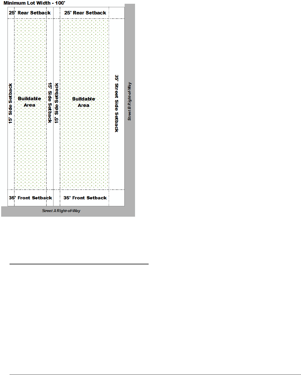
Oldham County Comprehensive Zoning Ordinance
Division 210 IPD Industrial Park District
52
Sec. 210-040 IPD Industrial Park District: Permitted Uses
All principally permitted uses in the C-1 Local Business District, C-2 Community Business District, C-3
General Business District, C-4 Highway Service District, and I-1 Light Industrial District are permitted
with the following exceptions and prohibitions:
1. Blacksmith Shop or Horse Shoeing Establishment
2. Boat Building
3. Commercial Indoor Rifle, Pistol and Skeet Ranges
4. Feed Mixing Plant
5. Foundry
6. Killing or Dressing and/or Packaging of Poultry and Rabbits
7. Manufactures Home Sales and Service
8. Planing Mill
9. Sawmill, Raw Log or Veneer Processing
10. Storage and Sales of Solid Fuel such as Coal, Coke and Wood
11. Stable
Additional Standards that may Apply:
Accessory Dwelling Units.…Sec 250-040
Accessory Uses & Struc.……Sec 250-030
Agritourism Buildings……….Sec 260-035
Barrel Warehouses……….....Sec 250-320
Brew pubs………………………..Sec 250-310
Distillery & Brewery………….Sec 250-300
Height………………………………Sec 330-010
Home Occupation…….…..….Sec 260-230
Fences & Walls…………….…..Sec 250-090
Capacity of Infrastructure…Division 270
Highway 53 Overlay Dist. ….Division245
Historic Preservation…………Division 240
Landscaping………………………Division 300
Lighting……………………………..Division 310
Parking………………………………Division 280
Signs……………………….…………Division 290

Oldham County Comprehensive Zoning Ordinance
Division 210 IPD Industrial Park District
53
Sec. 210-050 IPD Industrial Park District: Conditional Uses
All conditional uses permitted in the C-1 Local Business District, C-2 Community Business District, C-3
General Business District, C-4 Highway Service District, and I-1 Light Industrial District are permitted
with the following exceptions and prohibitions:
1. Asphalt Processing and Road Mix Plant
2. Auto Auctions
3. Commercial Composting
4. Commercial Rifle, Pistol and Skeet Ranges
5. Concrete, Central Mixing and Batching Plants
6. Extraction and Development of Oil, Gas, and other Hydrocarbons
7. Extraction and Development of Other Natural Resources
8. Extraction of Minerals – Rocks and Earth Products
9. Fertilizer, Incineration or Reduction Products
10. Grain, Feed and Fuel Storage Sales
11. Ham Curing Operations
12. Land-farming Facility for Solid Waste
13. Livestock, Hog, or Cattle Feeding Yards
14. Lumber Yards, including Incidental Millwork
15. Single-Family Manufactured Homes
16. Slaughter Houses, Rendering Plants, or Similar Conditional Uses
17. Solid Waste Incinerators
18. Vehicle Wrecking and Salvage Operations
Sec. 210-060 Parking Area Standards
A. Parking Surfaces
All parking surfaces, including driveway entrances and outside storage areas, shall be paved with
asphalt, concrete or paver blocks.
B. Parking Surface Completion & Maintenance
All parking surfaces shall be installed within ninety (90) days of the completion of the construction
of the building. Parking surfaces shall be continuously maintained in a state of good condition and
repair.
All parking areas shall be landscaped in accordance with applicable regulations. Parking areas
shall provide interior landscape areas of a least five (5) percent of the total parking/vehicle use
area. One tree for every 250 square feet should be provided in the interior parking area.
C. Parking Prohibitions
All parking areas shall be prohibited from the required front yard setback and side yard setback.
Driveway entrances may encroach in the front yard as provided in Section 210-030.

Oldham County Comprehensive Zoning Ordinance
Division 210 IPD Industrial Park District
54
Sec. 210-070 Outdoor Storage
A. Outdoor Storage Setbacks
All outdoor storage shall not be directly accessible by the general public, shall observe the
following minimum setbacks measured from the public rights-of-way lines or property lines:
Front Yard – 100 feet
Side Yard – 15 feet
Outdoor storage shall not encroach in the above listed front yard or side yard. Outdoor storage
shall be prohibited in required rear yards when adjoining residentially zoned properties.
There shall be no outdoor storage permitted for properties abutting an expressway. Outdoor
storage shall not be permitted in areas set outside, required, or designated for driving aisles,
driveways, maneuvering areas, emergency access ways or vehicular parking necessary to meet the
minimum number of off-street parking spaces.
B. Outdoor Storage Screening
Outdoor storage shall be screened from view and not visible from public rights-of-ways and
adjacent properties. Such screening may consist of privacy fence, wall or dense evergreen hedge.
C. Outdoor Storage Screening Completion & Maintenance
All outdoor storage area screening shall be installed prior to occupancy of the site. The required
landscaping shall be installed in conformance of the approved plan, required prior to requesting a
building permit, unless a full cash bond or an irrevocable letter of credit from a banking institution
timeframe may be approved by the Oldham County Planning Commission staff on an individual
basis. All outdoor storage screening shall be continuously maintained in a state of good condition
and repair.
D. Outdoor Display and Sales
There shall be no outdoor display or sale of item(s) allowed in the IPD District.
Outdoor Sales: Placement of any item(s) outside a building in a non-residential zone for the
purpose of sale or rent.
Outdoor Display: The exhibit of any item(s) outside a building in a non-residential zone as an
example of product(s) available for sale or rent.
Sec. 210-080 Aesthetic Standards
A. Building Façade
1. The first floor of any building oriented towards the front property line shall have a façade
comprised of one or a series of the following materials:
a. Textured Concrete Block

Oldham County Comprehensive Zoning Ordinance
Division 210 IPD Industrial Park District
55
b. Painted Scored Concrete Block
c. Brick
d. Tilt Up Concrete
e. Stucco Dryvit
2. The second floor of any building oriented towards the front property line shall have a façade
comprised of the same material as the first floor or architectural metal.
3. Accessory or auxiliary buildings shall be constructed of architectural metal or the same
material as the principal building.
B. Loading Areas
All loading areas, including overhead doors, shall be oriented towards the side or rear property
line. Loading areas oriented towards the front property line are prohibited. Loading docks are not
permitted in the front or street side yards.
1. Exterior site lighting shall not be any more than one (1.0) footcandle at the property line.
2. Landscaping
a. Front Yard/Street Side Yard:
The required front and/or street side yard shall be landscaped with a continuous cover of
grass or other type of ground cover. At a minimum, one tree per forty (40) feet of lot width
shall be required, and such trees shall have a minimum two (2) inch caliper at the time of
planting. Trees may be equally spaced or planted in groups. All parking areas and
maneuvering areas must provide a three (3) foot tall continuous hedge, wall, fence, or berm
or a decrease of three (3) feet in elevation from grade when adjoining a residential use or
zone or a public or private street, access road or easement, service road, freeway or arterial
street. Loading and unloading areas shall provide screening from street or adjacent
properties in the form of a continuous hedge or evergreen screening.
b. Side Yard:
The required side yard shall be landscaped with a continuous cover of grass or other type
of ground cover. Trees, a minimum of two (2) inch caliper at the time of planting, shall be
placed in all side and rear yards in numbers equal to one tree per seventy-five (75) lineal
feet of boundary. Trees do not have to be equally spaced. All side and rear yards shall
provide a fifteen (15) foot landscape strip that must be maintained and be free of buildings
and structures.
c. Yards Adjoining Residential Areas:
Side or rear yards adjoining residentially zoned properties shall be landscaped with a
combination of earthen berms and evergreen tree plantings. Such earthen berms shall be a
minimum of four (4) feet in height with evergreen tree plantings equally spaced a minimum
of every eight (8) feet on top of the earthen berm. The required earthen berm shall be
landscaped with a continuous cover of grass or other type of ground cover, and the required
evergreen trees shall have a minimum two (2) inch caliper at the time of planting.

Oldham County Comprehensive Zoning Ordinance
Division 210 IPD Industrial Park District
56
d. Landscape Completion and Maintenance:
Landscaping shall be installed prior to occupancy of the site in conformance with the
approved plan, required prior to requesting a building permit, unless a full cash bond or an
irrevocable letter of credit from a banking institution with offices in Oldham County has
been posted. An extension of the installation timeframe may be approved by the Oldham
County Planning Commission staff on an individual basis. Landscaping shall be
continuously maintained in a state of good condition and repair.
Sec. 210-090 Public Street Standards
A. Curb and Gutters
Public streets shall be designed and constructed with curbs and gutters.
B. Pavement & Rights-of-way Width
Public streets shall be designed and constructed with a minimum twenty-four (24) foot pavement
width excluding curbs. Dedicated rights-of-way for local public or private streets shall have a
minimum sixty (60) foot width.
C. Public Street Standards Exclusions
Public streets that have been identified by the legislative bodies as a minor or major arterial or
collector street may be constructed at a different standard than those listed above in order to allow
for flexibility in design and the possibility of future construction of additional traffic lanes.
Sec. 210-100 Driveway Entrances
A. Turning Radius
Driveway entrances shall be designed and constructed with a sufficient turning radius to prevent
damage to the edge of pavement. The turning radius shall be determined for each lot based upon
the anticipated types of vehicular traffic and width of the driveway entrance.
B. Headwalls
Headwalls for drainage pipes under driveway entrances shall be designed and constructed with a
slope and flare.
Sec. 210-110 Utilities
A. Public Utilities
All new public utilities, with the exceptions of primary overhead electric power, telephone, and
cable television, shall be installed underground.
B. Satellite Dishes, Storage Tanks & Antennas
Satellite dishes, storage tanks and antennas that are an accessory use to the principal structure may
be installed in areas outside the required front yard or side yard.

Oldham County Comprehensive Zoning Ordinance
Division 220 SWF-1 Solid Waste Facilities District
57
DIVISION 220 SWF-1 SOLID WASTE FACILITIES DISTRICT
Sec. 220-010 SWF-1 Solid Waste Facilities District: Intent
The primary purpose of the Solid Waste Facilities (SWF-1) zoning district is to establish location and
design standards that will:
1. Protect public health by preventing water pollution, air pollution, noise pollution, rodent
infestation, or other health hazards that may occur as a result of the improper location, design, or
operation of a solid waste facility.
2. Protect public safety and infrastructure by requiring proper design and construction of public
streets and private driving facilities to accommodate the heavy equipment necessary for the
collection, processing, transportation, and disposal of solid waste.
3. Promote compatibility with adjacent land uses by requiring adequate perimeter screening, activity
setbacks, and careful review of subsequent land uses allowed on a property closed solid waste
facility site.
4. Promote public welfare by providing a suitable location for the disposal of solid waste.
Sec. 220-020 SWF-1 Solid Waste Facilities District: Development Regulations
Minimum Lot Area:
None, except the site must be of sufficient area to
accommodate the required yard setbacks,
structures, driving facilities, parking areas, storage
areas, processing areas, disposal areas and any
minimum citing standards set forth in the Oldham
County Solid Waste Ordinance Nos. KOC-94-800,
KOC 97-830-53 and KOC 99-830-199.
Minimum Lot Width:
None
Maximum Structure Height:
50 feet (agriculture structures are exempt)
Minimum Front Yard Setback:
100 feet
Minimum Side Yard Setback:
100 feet
Minimum Street Side Yard Setback:
100 feet
Minimum Rear Yard Setback:
100 feet
Maximum Lot Coverage for Structures:
N/A
Maximum Impervious Surface Including Structures:
N/A
Sec. 220-030 Special Setback Requirements
1. The driveway entrance road originating on the public street may encroach in the required yard
setback area. Such driveway entrance road shall not consist of turnarounds, pulloffs, parking lanes
or parking areas.
2. The required yard setback area shall remain undisturbed except for the installation of buffering
provisions specified in this regulation.
3. All facility structures or land or water areas where solid waste management, processing or disposal
is physically located or conducted shall observe the following setbacks from property lines,
measured from the outside boundary of the structure or area:

Oldham County Comprehensive Zoning Ordinance
Division 220 SWF-1 Solid Waste Facilities District
58
Front Yard Setback – 250 feet
Side Yard Setback – 250 feet
Street Side Yard Setback – 250 feet
Rear Yard Setback – 250 feet
4. All facility structures or land or water areas where solid waste management, processing, or disposal
is physically located or conducted shall observe the following minimum distances, measures from
the outside boundary of the structure of the area:
Residential Structure – 1,000 feet
School or Church Property Line – 1,000 feet
Public Park Property Line – 1,000 feet
Institutional Structure – 1,000 feet
Industrial Structures – 500 feet
(Any structure or use listed above and located on the same property as the solid waste facility will
not be required to observe the minimum distances.)
The Commission or Board of Adjustments may require greater minimum distances than set forth
above if determined to be in the public’s best interest.
The appropriate Board of Adjustments retains authority to grant a variance from the minimum
distances in accordance with KRS 100 and Division 350 of this ordinance.
Sec. 220-040 SWF-1 Solid Waste Facilities: Permitted Uses
Solid Waste or domestic septage site or facility, including any place at which solid waste or domestic
septage is managed, processed or disposed, including:
1. Contained Landfill
2. Construction Demolition Debris Landfill
3. Residual Landfill
4. Landfarming or Landspreading Facility, including but not limited to any land application of
domestic septage or sewage
5. Commercial Recycling Centers
6. Recycling Facility
7. Transfer Facility
8. Solid Waste Incinerators
9. Convenience Centers
10. Commercial Composting
11. Salvage Yards
12. Sanitary Landfills
13. Metal, Glass and Paper Recycling Plant
14. Vehicle Wrecking and Salvage Operations

Oldham County Comprehensive Zoning Ordinance
Division 220 SWF-1 Solid Waste Facilities District
59
15. Any other solid waste site or facility for solid waste or domestic septage management, processing
or disposal by landfilling, incineration, landfarming, landspreading or any other method
16. Accessory structures incident to any of the above uses
17. Any use which, in the opinion of the Commission, is of the same general character as those listed
above.
Sec. 220-050 Access to Public Streets
A transportation plan must be submitted to show the public street routes to be used for heavy truck traffic
to and from the facility. Particular attention shall be given to the proper location and design of vehicular
access to the public street network. Attention shall be given to the adequacy of the public street network
serving the SWF-1 District to insure safe heavy truck traffic. The plan must demonstrate that heavy truck
traffic associated with the solid waste facility, particularly traffic traveling through residential areas,
narrow streets or bridges (less than 18 feet in width), low underpasses, grade railroad crossings, steep
grades on streets, and streets lacking shoulders, will not pose a hazard to public safety. Provisions for the
safe design of driveway entrances, deceleration turn lanes, and signage shall be set forth in the plan.
Access to public streets shall be a minimum of twenty (20) feet in width and must be properly permitted
by the state.
The requirement that any heavy truck traffic not pose a hazard to public safety may be addressed by
obtaining written comment from the appropriate transportation agency responsible for the maintenance
and improvement of the subject public street. These written comments must address the public safety
issue of allowing heavy truck traffic on an inadequate road and may include specific construction measures
to be undertaken to address the inadequacies.
Sec. 220-060 Driving Facilities
The minimum driving facilities shall be constructed:
1. Driveway entrance roads shall be paved with an all weather surface material and no-dusting
material, such as asphalt, concrete or paver blocks, a distance of 250 feet from its entrance with
the public street.
2. Driveway entrance roads shall be of sufficient width to accommodate two-way heavy truck traffic
as recommended by the county engineer or the State Transportation Cabinet.
3. Drop-off and sorting areas and pads shall be constructed of an all weather surface material and
non-dusting material, such as concrete, asphalt or paver blocks.
4. All driveways, internal roads, and parking areas, with the exceptions listed above, shall be
constructed with gravel or a non-dusting material such as asphalt, concrete or paver blocks. The
construction standard and maintenance of driveways, internal roads, and parking areas shall be
sufficient to prevent the tracking of mud or debris onto the public streets. If these conditions
cannot be met or there is tracking of mud or debris onto the street, wheel washers shall be installed
on site.

Oldham County Comprehensive Zoning Ordinance
Division 220 SWF-1 Solid Waste Facilities District
60
Sec. 220-070 Buffering
Particular attention shall be given to the installation and maintenance of buffering to adequately screen
the SWF-1 District from adjoining properties and public rights-of-way. Buffering measures may include
earthen berms, existing mature tree lines, evergreen plantings, screening fences, and ridges or slopes. A
buffering measure or any combination of buffering measures must adequately screen the solid waste
facility from the adjoining properties and public rights-of-way. Earthen berms shall not exceed four (4)
feet in height and be constructed in a manner to prevent slumpage and erosion. Earthen berms shall be
seeded with a permanent grass cover and properly maintained.
The buffering measures are to be located with the setback areas specified above and along the entire
perimeter of the SWF-1 District.

Oldham County Comprehensive Zoning Ordinance
Division 230 PUD Planned Unit Development District
61
DIVISION 230 PUD PLANNED UNIT DEVELOPMENT DISTRICT
Sec. 230-010 Planned Unit Development District: Intent
A Planned Unit Development (PUD) is defined as an area with a specified minimum contiguous acreage
to be developed as a single entity according to a plan for residential and non-residential uses. PUDs
usually include provisions for the clustering of buildings, a mixture of land uses and building types,
preservation of natural resources, and promotion of common open space. The purpose of PUD regulations
is to encourage and allow more creative and imaginative design of land development than is possible under
conventional zoning regulations. This can be achieved by providing more flexibility in terms of
development standards and requirements such as setback and yard area, lot size and dimensions, and
building height. Ideally, this flexibility results in a development that is better planned, contains more
amenities, is more desirable to live and work in and, ultimately, provides substantial benefits to the
community environment compared to the conventional zoning districts.
A Planned Unit Development shall be a design alternative and not a density alternative. Each PUD shall
be properly planned and designed to include features that further, and are in compliance with, the
following objectives:
• To promote design creativity and excellence that will result in high-quality development;
• To allow a mixture of land uses and building types not otherwise allowed in a conventional zoning
district by careful planning that establishes compatible relationships between uses within the site
and adjacent to the site;
• To combine and coordinate architectural styles, building forms and heights, and structural/visual
relationships within an environment that allows mixing of different land uses and building types
in an innovative and functionally efficient manner;
• To encourage creative site design that seeks to preserve natural resources and unique
environmental and cultural features, and to ensure that development occurs on land physically
suited to proposed construction away from environmentally sensitive areas;
• To provide for abundant, accessible and properly-located open and recreational space, schools and
other public and private facilities;
• To promote the efficient use of land resulting in networks of utilities, streets and other
infrastructure features that maximize the allocation of fiscal and natural resources;
• To conserve energy through efficient building design and clustering, efficient use of the land and
increased efficiency of public service delivery;
• To incorporate planning, design and construction techniques that minimize negative impacts on
the environment and on human quality of life; and,
• To create a development pattern consistent with the adopted Comprehensive Plan.
Sec. 230-020 General Standards and Requirements
The following are general standards and requirements for Planned Unit Developments:

Oldham County Comprehensive Zoning Ordinance
Division 230 PUD Planned Unit Development District
62
1. Comprehensive Plan: A PUD must comply with the goals and objectives of the currently
adopted Oldham County Comprehensive Plan.
2. Size and Ownership of Site: The minimum size of an area required for a PUD zone shall be no
less than ten (10) contiguous acres under single ownership and/or unified control.
3. Mixed Use Development: A PUD shall generally have a mixed-use orientation (combination of
residential of various densities, commercial, institutional, recreational, and/or industrial uses)
including accessory uses.
4. Compatibility: Measures shall be taken to assure compatibility of land uses within a PUD itself
and with adjacent sites. When a PUD abuts a lower density/intensity land use or zoning district,
a fifty-foot (50’) perimeter landscape buffer shall be provided in all areas of the PUD adjacent to
the lower density/intensity land use.
5. Open Space: A minimum of ten percent (10%) of the land area should be set aside for Open
Space. A PUD with primarily residential use (more than fifty percent of the land area used for
residential), a minimum of twenty-five percent (25%) of the land area should be set aside for
Open Space.
a. At least seventy percent (70%) of the required Open Space shall be Common Open Space;
b. Open Space shall be distributed equitably throughout the PUD for easy access by all
residents or property owners;
c. A minimum of five thousand (5,000) square feet of contiguous area is required in order to
be considered as Open Space.
d. Privately-owned residential lots less than ten (10) acres shall not be included in the Open
Space calculations;
e. Open Space restrictions or easement shall be permanent;
f. No more than fifty percent (50%) of the required Open Space shall be covered by water;
and
g. Amenities for community use may be included within the Open Space calculations.
6. Preservation of Natural Resources and Existing Site Features: To the greatest extent possible, the
following natural resources and existing site features shall be preserved and incorporated into the
project design:
h. Archeological sites, historic sites and cemeteries;
i. Existing significant trees (a diameter breast height of twenty-four inches (24”) or greater);
j. Habitat for endangered or threatened species;
k. Healthy mature woodlands (total combined canopy covers one (1) acre or more);
l. Slopes greater than twenty percent (20%) of at least five thousand square feet (5,000’
2
)
contiguous area;
m. The 100-year floodplains;
n. Water courses, water bodies over five thousand (5,000) square feet contiguous area; and,
o. Wetlands meeting the Army Corps of Engineers’ jurisdictional wetland standards.
7. Pedestrian Orientation: In general, a PUD shall have a pedestrian orientation. Sidewalks
and/or trails shall be provided.

Oldham County Comprehensive Zoning Ordinance
Division 230 PUD Planned Unit Development District
63
8. Multi-Modal Transportation Systems: A PUD shall incorporate multi-modal transportation
elements through the development depending on the foreseeable needs of future residents and
users of the site and the relationship of the project site to the community at large. Such multi-
modal elements may include provisions for mass transit stops or stations, car pooling lots,
pedestrian and bicycle paths and lanes, and bicycle parking areas.
9. Transporation Connections and Entry Points: The provision of transportation connections (street
connections, pedestrian paths and sidewalks, bicycle facilities) shall be provided in all PUDs
unless physically unfeasible or undesirable due to land use characteristics. In addition, the
various entry points into a PUD shall be marked or otherwise defined through the use of
professionally designed landscaping, signage, architectural or sculptural elements, archways,
markers and lighting when appropriate.
10. Architecture: An architectural theme shall be provided in PUDs. The architectural theme shall
relate to existing structures on the project site and adjacent sites, especially if such existing
structures are historic. The use of architectural guidelines is required for multi-phased projects.
11. Landscaping: A PUD may establish alternative landscaping and buffering standards in lieu of the
current Landscaping Regulations. However, street trees and screening of parking that adjoins
public rights of way shall be provided. The use of landscape design guidelines is required for
multi-phased projects.
12. Signage: A PUD may establish alternative signage standards in lieu of the current Signage
Regulations. A consistent signage theme shall be provided within a PUD. The use of signage
design guidelines is required for multi-phased projects.
13. Lighting: A PUD may establish alternative lighting standards in lieu of the current Lighting
Regulations. A consistent lighting theme shall be provided within a PUD. The use of lighting
design guidelines is required for multi-phased projects.
14. Fencing Walls and Gates: A fencing and wall theme shall be provided within a PUD. The use of
fencing and wall design guidelines is required for multi-phased projects.
15. Roads: All roads shall be constructed in accordance with the requirements and standards in
the Roadway Construction Standards for Oldham County as found in the Oldham County
Subdivision Regulations.
16. Capacity Analysis: Traffic impact analysis, utility capacities, school capacity and other capacity
analyses may be required.
17. Digital submission of plans: The Developer shall place public monumentations within the PUD,
and submit plans in digital format (in addition to paper format) in accordance to the digital
submission standards as established by Oldham County.
18. Compliance with Other Regulations: Unless expressly authorized by the provisions of this
Article and specifically approved as part of a PUD, none of the otherwise applicable Regulations
and Ordinances may be waived or reduced as part of a PUD approval.
Sec. 230-030 Uses Permitted and Prohibited
The following are general standards and requirements for Planned Unit Developments: Most uses or
mixture of uses may be approved within a PUD, provided that uses within the site are compatible and not

Oldham County Comprehensive Zoning Ordinance
Division 230 PUD Planned Unit Development District
64
injurious to the adjacent neighborhood or otherwise detrimental to the public health, safety, moral or
general welfare. Only the specific uses proposed in an approved application shall be allowed in the district.
The following uses are prohibited in a PUD either as a single use or as part of a mixed use:
1. Adult Entertainment
2. Building-mover and wrecker’s establishment
3. Confined animal feeding operations
4. Feed mixing plant
5. Foundry, casting of metals
6. Killing or dressing and/or packaging of poultry and rabbits
7. Manufactured home sales and service
8. Planing mill
9. Quarry, gravel pit or stone mill
10. Railroad repair shop
11. Rock, sand, slag or gravel distribution
12. Rolling mill
13. Salt works
14. Saw mill, raw log or veneer processing
15. Slaughter houses and the rendering of lard
16. Solid fuel such as coal, coke and wood storage and sales
17. Storage and distribution of explosives or inflammables, garbage, offal or dead animals, rags,
metal or junk, petroleum and petroleum byproducts in excess of an amount necessary for use of
the premises
18. Truck Terminals
19. Uses related to Solid Waste excluding fill area for construction site and material used during
construction
20. Wholesale lumber storage, millwork and sales
21. Other Heavy Industrial Uses
22. Other uses as determined by the Commission as not appropriate
Sec. 230-040 Density, Intensity and Dimensional Standards
Density, intensity, dimensional and bulk standards (i.e. lot size, lot width, setback, and height standards)
shall be established for each proposal as part of the PUD approval.
Sec. 230-050 Phased Development
A PUD may be developed in one phase or multiple phases. For a multiple-phased development, the
required Master Plan must cover the entire site. A Development Plan may cover one section of the PUD
and may be submitted in phases. In the event that the developer seeks to modify the approved time
schedule, such modification shall require the approval of the Commission. The Commission shall, in
deciding whether to grant approval of the modification shall consider the availability and capacity of
public facilities to accommodate the proposed developments.

Oldham County Comprehensive Zoning Ordinance
Division 230 PUD Planned Unit Development District
65
Sec. 230-060 Procedures
A PUD approval includes five (5) steps. The first step, concept plan review, requires a pre- application
conference with Commission staff and a neighborhood meeting. The second step is to secure approval of
the Master Plan by the Commission and the appropriate legislative body to make a zoning map
amendment. The third step, Development Plan Review (can substitute the Preliminary Plan for
Subdivisions), may cover an entire development site or a section of the development and is approved by
the Commission. The fourth step, consisting of the Construction Plan and Record Plat Review, is
required under the Subdivision Regulations and is approved by the County Engineer and the Commission
Staff. The final step, Site Plan review, must be approved by the County Engineer and the Commission
Staff before any building permits can be issued for all uses other than Single-Family Detached dwellings.
1. Concept Plan Review: A Concept Plan (or Sketch Plan) shall be prepared for a neighborhood
meeting and may be used for discussion with Planning and Zoning staff. The Concept Plan should
show the following:
Boundary and approximate acreage of the subject property; the general location of existing
natural and cultural resources; the general location of proposed access points along the existing
road network; the general location of proposed land uses; approximate residential units proposed
and approximate square footage of non-residential uses; and existing and proposed streets.
a. Pre-Application Meeting: If a property owner proposes a PUD district, he or she shall
meet with Planning and Zoning staff prior to the submission of a Master Plan. The
purpose of the meeting will be to discuss the purpose and effect of this Article and the
criteria and standards which may apply, and to outline the procedures and tentative
schedule for the process. Upon completion of the Concept Plan, the applicant may
request another meeting with Planning and Zoning staff for review of the Concept Plan.
The applicant may choose to combine these two meetings.
b. Neighborhood Meeting: A meeting with identified neighbors (tier one property owners
and owners of properties located within five hundred feet (500’) of the PUD) is required
to facilitate the identification and possible resolution of community concerns. The
applicant will need to provide the Commission staff with a list of adjoining property
owners as well as certification that each property owner listed was notified of the meeting
at least 14 days prior to the meeting. The applicant shall submit with the zoning map
amendment request a sign-in sheet from the meeting and a brief statement detailing issues
raised at the required meeting with the neighbors and solutions proposed.
2. Master Plan Review: Following the pre-application meeting(s) and neighborhood meeting, a
Master Plan shall be prepared and submitted for review, accompanied by a filing fee and an
application for a zoning map amendment.

Oldham County Comprehensive Zoning Ordinance
Division 230 PUD Planned Unit Development District
66
a. Technical Review Committee: The Master Plan shall be submitted for review by the
Technical Review Committee. Comments from the Technical Review Committee should
be addressed and incorporated into the Master Plan as much as possible.
b. Planning and Zoning Public Hearing: Upon receipt of an application for approval of a
Master Plan and zoning map amendment, the Commission shall hold a public hearing
after notice as required under Kentucky Revised Statutes, Chapter 424. After the public
hearing, the Commission shall find:
i. that the Master Plan is consistent with the intent, purpose, requirements and
standards of this Article;
ii. that the proposed development advances the general welfare of the community
and neighborhood;
iii. that the benefits, combination of various land uses, innovation of physical design
and the inter-relationship with the land uses in the surrounding area justify any
deviations from conventional zoning districts; and
iv. the proposed development and zoning map amendment are in agreement with the
adopted Comprehensive Plan.
The Commission will make a recommendation to the legislative body for either approval,
approval with conditions, or denial of the Master Plan and zoning map amendment.
c. Appropriate legislative body or bodies: Following action by the Commission, the
application shall be considered by the appropriate legislative body or bodies. Based on
the application as amended and the recommendation of the Commission, the legislative
body or bodies shall approve, remand to the Commission for amendments or additions or
deny the application. If the application is approved by the appropriate legislative body or
bodies, this approval constitutes a commitment to the general layout of the project,
planned land-use types, density/intensities, design treatments and other particulars as
shown on the Master Plan. However, the approval of the Master Plan shall not be
construed to endorse engineering feasibility of plan elements that do not meet the
development standards of the Comprehensive Zoning Ordinance or the Subdivision
Regulations unless an exception is specifically granted through the review and approval
of the Master Plan.
d. Zoning Map Amendment: A property is rezoned to a PUD upon approval of the Master
Plan by the appropriate legislative body or bodies having zoning authority over the
subject property. The Commission shall maintain records of the Master Plan and all
conditions or binding elements the Commission and the legislative body or bodies have
approved pertaining to the zoning map amendment. The official Zoning Map shall be
amended to reflect the new PUD zoning of the subject property.
A Development Plan for all of a PUD or a section of a PUD shall be submitted for approval
within twenty-four (24) months of the date of the Master Plan approval. The developer may

Oldham County Comprehensive Zoning Ordinance
Division 230 PUD Planned Unit Development District
67
request an extension in writing to the Commission prior to the expiration date for additional
twelve (12) months. Two subsequent requests may be made in writing for additional periods
of time of no more than twelve (12) months each. As part of the Master Plan extension
approval, the Commission may request updated infrastructure impact analyses, such as a new
traffic study.
3. Development Plan Review: After approval of a Master Plan and Zoning Map Amendment, a
Development Plan shall be submitted for review, accompanied by a filing fee.
a. Technical Review Committee: The Development Plan for the entire PUD site or any one
phase of the PUD shall be submitted for review by the Technical Review Committee.
Comments from the Technical Review Committee should be addressed and incorporated
into the Development Plan.
b. Planning and Zoning Commission Public Hearing: This Development Plan can also serve
the purpose of a Preliminary Plan for subdivisions. The Commission shall review the
Development Plan to determine compliance with the approved Master Plan, specific
guidelines and requirements of this Article, and the terms of any prior conditional
approval of the project. If the Commission finds that the Development Plan is not in
compliance with the approved Master Plan, the applicant may (a) revise the Development
Plan to comply with the approved Master Plan; or (b) apply for an amendment to the
approved Master Plan. The Commission shall then approve the Development Plan,
approve it with conditions, or deny it and state the reasons for denial.
Approval of a Development Plan shall be valid for two (2) years during which time the developer
shall obtain approval of Construction Plan and Record Plat (if any). Extensions may be granted in
accordance with the Subdivision Regulations.
The applicant has the option to submit the Development Plan simultaneously with the Master Plan
Review and zoning map amendment application. In such cases any approval of Development
Plans must be conditioned upon the approval of the Master Plan and zoning map amendment. If
the approved Master Plan includes any additions or conditions by the legislative body, any
Development Plan undergoing simultaneous review will be subject to those additions or conditions
and may be reviewed by the Commission again to ensure compliance with the approved Master
Plan.
4. Construction Plan and Record Plat Review:
a. Review of Construction Plan: The applicant shall obtain approval of Construction Plans
in accordance with the Subdivision Regulations.
A Soil and Erosion Control Plan shall be submitted prior to or simultaneously with the
Construction Plan and shall comply with the Oldham County Stormwater Ordinance. No
land-disturbing activities shall begin prior to issuance of a Soil and Erosion Control

Oldham County Comprehensive Zoning Ordinance
Division 230 PUD Planned Unit Development District
68
Permit beyond what is necessary for site analysis and plan design. In addition,
land-disturbing activities on slopes greater than twenty percent (20%) shall be required to
prepare a geotechnical survey report. The geotechnical survey report shall be prepared by
a professional engineer licensed in the State of Kentucky whose area of practice includes
geotechnical engineering. The report shall include mitigation measures as needed to
ensure stability and minimize environmental impact during site preparation and
construction.
b. Review of Record Plat for Subdivisions: The applicant shall obtain approval of the
Record Plat in accordance with the Subdivision Regulations. Prior to approval of a
Record Plat, the following information shall be filed with the Commission and approved
by the Commission attorney:
i. Conservation easements and/or supporting covenants shall be filed among the
land records that enumerate the property owners’ association and all
successors’ obligations for perpetual maintenance of all common and private open
space;
ii. Documentation of approval of any receiving entity (such as a public agency or a
land trust) that is different than the property owners’ association if any open space
is to be dedicated to that entity.
5. Site Plan Review: Prior to the issuing of building permits, site plans, accompanied by filing
fees, shall be submitted for review for all uses other than Single-Family Detached dwellings for
approval by the County Engineer and the Commission staff. All site plans shall be prepared in
accordance with the Site Plan Review requirements established under the Planning and Zoning
Administrative Policies.
The developer or the property owners’ association or its designee will be required to certify
conformance with deed restrictions and architectural standards prior to submittal of the site plan
for review and approval.
Sec. 230-070 Conditions of Approval in Master Plan and Development Plan
Conditions of approval in a Master Plan and in a Development Plan may be written or graphic and, where
agreed upon by the Commission or the appropriate legislative body, shall become a fundamental part of
the Master Plan or Development Plan.
Sec. 230-080 Amendments to an Approved Master Plan or Development Plan
Any amendment to the Master Plan or Development Plan (including maps and reports) must be approved
by the Commission.
Variances do not apply to PUDs because the specific development standards of the PUD district are
contained in the approved Development Plan for each PUD, and because the Development Plan normally
takes into account those matters which might otherwise be the subject of variance review by the Boards

Oldham County Comprehensive Zoning Ordinance
Division 230 PUD Planned Unit Development District
69
of Adjustments. Amendments to an approved Master Plan and Development Plan shall follow the
following procedure:
a. Minor amendments: The Administrator is authorized to approve minor changes to the
approved Master Plan or Development Plan. Minor changes include decrease in density
and intensity, consolidation and shifting of lot lines, land use and street modifications that
would not negatively affect adjacent properties.
The Administrator must present any major amendment to an approved Master Plan or
Development Plan to the Commission prior to approval.
b. Major amendments: Major amendments include reduction in lot sizes, increase in density
or intensity, street modifications that would affect adjacent properties, change in points of
street access onto existing streets, change in the time schedule, changes in the
supplemental conditions of approval or other changes deemed major by the
Administrator.
The Commission may review and approve major amendments to the approved Master
Plan or Development Plan without a public hearing. The Commission may require a
public hearing for the amendment when it deems necessary.
Sec. 230-090 Master Plan Requirements
The applicant seeking zoning map amendment for a PUD district is required to prepare a Master Plan for
approval either prior to, or concurrent with, any Development Plan. The Master Plan shall be prepared
according to the following requirements:
1. Master Plan Maps: This map or maps shall be drawn and submitted at a scale not less detailed
than one inch equals two hundred feet (1”=200’), or other scale acceptable to the Commission
staff.
a. Existing Condition Map(s):
i. Title Block: The Master Plan shall contain a title block placed in the lower right
hand corner of the plan showing the name of the development preceded by the
words “Master Plan”; the names, mailing addresses, telephone numbers of the
property owner, the developer and the person or firm preparing the plan; date of
preparation; and graphic and written scale.
ii. Vicinity Map: A sketch map with a north arrow showing the relative location of
the proposed development to surrounding streets and community facilities.
County and City boundary lines shall also be shown within one half mile of the
PUD.
iii. Boundary Lines: The location, distances and bearings for property boundary lines
per deed or survey. Site identification shall include a list by tax map and parcel
number of all existing parcels to be rezoned.

Oldham County Comprehensive Zoning Ordinance
Division 230 PUD Planned Unit Development District
70
iv. Adjacent Property: Names, addresses, parcel numbers and approximate
boundary lines of all properties adjacent to or across any streets or water bodies
from the subject property and properties within 500 feet of the subject property as
shown on the most recent tax records. Properties located across I-71 or the Ohio
River from the subject property are not required to be shown.
v. Existing Zoning: Zoning and density/intensity of existing development, if any.
vi. Existing Topography: Topographic contours at two (2) foot intervals
referenced to established and published sea level datum and mapping shall be to
national standards of mapping and of sufficient detail to show the general
character of the land. Natural slopes greater than twenty percent (20%) of 5,000
square feet or more shall be graphically indicated and labeled.
vii. Other Existing Natural Features: Areas of substantial existing trees including a
general description of their type and size; marshes, water bodies, water
courses, 100-year floodplains, wetlands, soil types; and other natural features
which might affect the design of the subdivision.
viii. Existing Historic Structures: Locations, dimensions, dates of construction, and
architectural styles of historical structures and sites, original accesses to historical
structures and sites for all structures, buildings, and sites
ix. Other Existing Manmade Features: Manmade features such as overhead
utilities, houses, barns, outbuildings, fence rows, streets, driveways,
cemeteries, railroads, and other manmade features which might affect the
design of the subdivision.
x. Existing easements and deed restrictions: Location, width and purpose of all
easements and mineral rights and the nature and location of deed-restricted areas.
xi. The location and name of all existing streets, sidewalks and existing land uses.
xii. Such additional information as the Commission and staff may require.
b. Master Plan Map(s):
i. A general land use plan indicating the proposed land uses, including the
proposed types of residential and nonresidential uses. The location and
acreage of each proposed use.
ii. A circulation plan showing the layout of proposed streets, bikeways, pedestrian
paths and other multi-modal elements such as the location of proposed transit
shelters within the planned development and any proposed improvements to the
existing transportation system outside the planned development.
iii. An open space plan showing the general location and acreage of open space areas
to be set aside for conservation and recreational purposes with an indication for
each whether it will be privately-owned or commonly-owned open space.
iv. A community facility plan indicating the location and acreage of proposed
community facilities and civic uses.

Oldham County Comprehensive Zoning Ordinance
Division 230 PUD Planned Unit Development District
71
v. A general utility plan indicating the general locations for main utility lines serving
the proposed PUD including water, sanitary sewer, natural gas, electric power,
telephone and cable TV.
vi. A stormwater management plan: indicating how existing drainage conditions
would be changed as a result of the proposed development and the general
location of proposed detention and retention basins.
vii. A landscaping plan showing the general location of proposed landscaping.
viii. Such additional information as the Commission and staff may require.
2. Master Plan Report:
a. Ownership and Legal Description of Site: A legal description per deed or survey of the
proposed PUD site submitted along with the signature(s) of property owner(s).
b. Purpose and intent: A statement indicating the purpose and intent of the project and the
applicant’s statement of how the project complies with the Comprehensive Plan and the
General Standards of this Article.
c. A sign-in sheet from the required neighborhood meeting and a brief statement
detailing issues raised at the required meeting with the neighbors and solutions or
consolations presented or proposed. A copy of the sign-in sheet and statement shall be
mailed by the developer to each identified neighbor whether present or absent at the
meeting.
d. Land Use: A description of the mix of land uses and the factors which ensure
compatibility both within the development site and with adjacent land uses.
e. Circulation: An analysis for pedestrian, bikeway and vehicular circulation describing the
general design capacity of the system as well as access points.
f. Street design standards: Minimum pavement width, right-of-way width, presence of
curbs, on-street parking, street trees, street furniture, bikeways, sidewalks, and street
cross-sections for each type of street classification proposed.
g. Site design standards: specifying density, intensity, dimensional and bulk standards (i.e.
minimum lot size, minimum lot width, minimum setbacks, maximum Floor Area Ratio,
and maximum and minimum building height standards), maximum lot coverage and
frontage of building facades for all uses.
h. Architectural design standards: specifying materials and configuration permitted for
walls, roofs, openings and other elements, or architectural guidelines to be
incorporated into the PUD’s Master Declaration of Covenants and Restrictions and
administered by an architectural review committee.
i. Stormwater management: describing pre- and post-runoff conditions of downstream
drainage systems, types of planned drainage facilities and proposed mitigation of
negative impacts.
j. Impact: School, water, sanitary sewage facility impact estimates.
k. Propose standards for the following:
i. Signage;

Oldham County Comprehensive Zoning Ordinance
Division 230 PUD Planned Unit Development District
72
ii. Exterior lighting;
iii. Landscapingl
iv. Fencing, walls and gates; and,
v. Off-street parking.
l. Statistical information including the following:
i. Gross acreage of the site, plus net acreage of the site excluding jurisdictional
wetlands, 100-year floodplains, water bodies, and slopes greater than twenty
percent (20%);
ii. The maximum number of dwelling units requested;
iii. The maximum amount (gross leasable area) of retail, office, industrial and any
other non-residential uses;
iv. The minimum amount of land devoted to open space expressed in acres and as a
percentage of the gross acreage of the site for passive and active uses; and,
v. The minimum amount of land devoted to civic uses expressed in acres and as a
percentage of the gross acreage of the site.
m. Slopes greater than twenty percent (20%) of at least 5,000 square feet contiguous area: a
general statement of impact of the development as well as mitigation measures shall be
included.
n. A schedule for the proposed development (or for each phase, if it is to be developed by
phases) containing the following information in order to show generally how the
applicant will complete the project:
i. The order of construction by phase delineated on the Master Plan;
ii. The anticipated time required to develop each phase;
iii. The proposed schedule for construction of improvements to open space areas;
iv. The proposed schedule for the installation of required public roadways, utilities or
other infrastructural improvements, utility relocations, and the dedication of
public rights of way, easements and properties.
o. Such additional information as the Commission and staff may require.
Sec. 230-100 Development Plan
The applicant shall prepare a Development Plan to proceed with a PUD. Development Plans shall be
prepared by a design team consisting of a professional engineer licensed in the State of Kentucky and one
or more of the following: a professional architect licensed in the State of Kentucky, a certified planner, a
professional land surveyor licensed in the State of Kentucky or other professionals. In lieu of a
Preliminary Subdivision Plan, a Development Plan consisting of a set of maps and a written report shall
be prepared according to the following requirements.
1. Development Plan Maps: This map or these maps shall be drawn and submitted at a scale not
less detailed than one inch equals one hundred (100) feet, or other scale acceptable to the
Commission staff and shall contain the following:
a. Title Block: The Development Plan shall contain a title block placed in the lower right
hand corner of the plan, showing the name of PUD preceded by the words “Development

Oldham County Comprehensive Zoning Ordinance
Division 230 PUD Planned Unit Development District
73
Plan”; the names, mailing addresses, telephone numbers of the property owner, the
developer, and the person or firm preparing the plan; date of preparation; and graphic and
written scales.
b. Master Plan Maps: All maps included in the Master Plan shall be provided.
c. Property Line Survey: A property survey (including the entire PUD) certified by a
professional Land Surveyor licensed in the State of Kentucky is required.
d. Proposed Streets: Location, name and widths of all proposed street and alley rights of
way within or adjacent to the proposed project; access points designated for use by
construction vehicles; total trip generation projected for the development; street
classification of each street within or adjacent to the project in accordance with intended
use based on design and total trip generated, such as local, collector, or arterial, which
shall be shown within parentheses next to the existing and proposed street names.
e. Proposed sidewalks, trails and other multi-modal transportation facilities: The
location and width of all proposed sidewalks, trails and other multi-modal transportation
facilities shall be shown.
f. Proposed Land Uses: Location and proposed land uses which shall include the
following information:
i. Total acreage of all uses, total acreage of each individual use and acreage of each
individual section or phase, if any;
ii. Gross density/intensity of all uses and the gross density of each individual
section or phase, if any;
iii. Net density/intensity of all uses and the net density of each individual section or
phase, if any;
iv. Total number of dwelling units by types and the number of dwelling units by
types of each individual section or phase, if any;
v. Overall floor area ratio and the floor area ratio of each individual
nonresidential section or phase;
vi. Number of off-street parking spaces;
vii. Total square footage of each nonresidential uses (commercial, industrial,
community facilities, etc.) and each nonresidential building;
viii. Types, acres and locations of common open space and amenities; and,
ix. Lot lines, lot dimensions, areas of each lot and lot numbers.
g. Building Elevation: Typical front elevation views for all proposed uses.
h. Street and Exterior lighting: Typical street lighting and exterior lighting.
i. Sections of streetscapes: Cross sections of typical streetscapes including centerline of
streets, width of streets or lanes, on-street parking if any, curbs, street trees, sidewalks,
building setbacks, front portion of typical buildings.
j. Signs: For commercial and industrial projects, conceptual sign plans showing sign type,
size and location must be included.
k. Open space: The design and location of private and public open space must be shown.
l. Utility Easements: Show the location of utility easements.

Oldham County Comprehensive Zoning Ordinance
Division 230 PUD Planned Unit Development District
74
m. Such additional information as the Commission and staff may require.
2. Development Plan Report: A written report on Development Standards shall be submitted,
which will explain the type, nature, size, intent and characteristics of the proposed development
and shall include the following information:
a. General description and location.
b. The physical and socio-economic reasons as to why the uses proposed in the PUD
c. would produce a better overall use of this property over the conventional zoning.
d. The proposed provision of utilities, including water, sanitary sewer and drainage
facilities.
e. The proposed methods for protection of abutting properties.
f. The proposed densities and total number of acres or square footage for each type of land
use, including public facilities and common open space or recreational areas.
g. The proposed maintenance and ownership agreements for any streets and common open
spaces not proposed for dedication to a public entity.
h. The proposed standards of development for all proposed uses, including restrictions on
the use of property, lot sizes, setback requirements, height restrictions and proposed
covenants.
i. A general statement addressing lighting proposed for the development.
j. A general statement addressing tree preservation and protection during construction and
landscaping proposed for the development.
k. A general statement addressing sign controls proposed for the development.
l. A general statement indicating the substance of restrictive covenants, grants of
easements, or other restrictions imposed, or to be imposed, upon the uses of the land,
buildings and structures in the development including proposed easements for utilities
and greenways.
m. A statement describing the probably impact of the development on the following:
i. Water facilities;
ii. Sewer facilities;
iii. Public roadways;
iv. Stormwater runoff;
v. Schools; and
vi. Police, fire, and recreational facilities.
n. Such additional information as required by the Commission or staff.
Sec. 230-110 Site Plan Requirements
1. Applicability: Site plan approval shall be obtained for all developments other than those for
Single-Family Detached dwellings located in a Planned Unit Development (PUD) district that
meet one or more of the following criteria:
a. New construction;
b. An addition/expansion that will contain more than five hundred (500) square feet; and,

Oldham County Comprehensive Zoning Ordinance
Division 230 PUD Planned Unit Development District
75
c. An addition/expansion that will contain more than fifty (50) percent of the original square
footage.
2. Specific Information Required: Site plans shall be drawn and submitted at a scale not less than
one (1) inch equals fifty (50) feet, or other scale acceptable to the Commission staff. All site
plans shall contain the following:
a. Name of PUD in which the site is situated.
b. Address and lot number of the site.
c. Vicinity map drawn to scale of one (1) inch equals one thousand (1,000) feet or other
scale acceptable to the Commission staff, which shall include streets and corporate limit
lines within a one-half (0.5) mile radius of the site.
d. Names, addresses and telephone numbers of the owner and the applicant.
e. City, county and state.
f. Date.
g. Names, addresses, telephone numbers, and seals (on the section of the plan that they
prepare) of all professional consultants participating in the preparation of the site plan.
h. North arrow with basis of meridian stated.
i. Acreage or square footage of the site.
j. Minimum required front, side and rear setback lines.
k. Location of the 100-year floodplains per FEMA maps or other data.
l. Wetlands meeting the Army Corps of Engineers’ jurisdictional wetland standards.
m. Linear and nonlinear water bodies.
n. Existing and proposed land contours showing vertical intervals no greater than two (2)
feet based on national mapping standards or equivalent.
o. Name of owner(s), address and tax parcel numbers of adjoining properties.
p. Bearings and distances for all boundaries of the site.
q. A sheet showing all proposed improvements overlaid on the existing topography
indicating what natural features will be destroyed or disrupted.
r. Existing and proposed easements with dimensions and designated type.
s. Existing and proposed locations, types and sizes of the following:
i. Water lines.
ii. Fire hydrants.
iii. Sanitary sewers.
iv. Stormwater infrastructure.
v. Culverts with inlet and outlet elevations.
vi. Street improvements.
vii. Electric lines.
viii. Gas lines.
ix. Any other utilities or services that serve or affect the site.
t. Parking layout and traffic control plan to include the locations and dimensions of the
following:

Oldham County Comprehensive Zoning Ordinance
Division 230 PUD Planned Unit Development District
76
i. Vehicle entrances, exits and drives.
ii. Handicapped entrances, exits, walks and ramps.
iii. Vehicle parking spaces.
iv. Widths of vehicular traffic aisles.
v. Truck loading and unloading spaces and docks.
vi. Proposed traffic control devices.
u. Location, style and material of proposed screening, fencing and walls.
v. Landscaping plan drawn and sealed by a landscape architect licensed in the State of
Kentucky and placed on a separate sheet indicating the following:
i. Acreage of proposed landscaping area.
ii. List of existing and proposed landscaping materials. Specify names, types,
quantities, and sizes.
iii. Locations of existing and proposed landscaping materials shall be shown in
accordance with the latest Landscaping Regulations.
iv. Maintenance agreements.
w. Lighting plan:
i. Locations of proposed lighting.
ii. Types of lighting with details shown on the plan.
iii. Typical radius of light.
iv. Intensity in foot-candles.
x. Locations, dimensions, dates of construction and architectural styles of documented
historic structures and sites, original accesses if known to historic structures and sites,
and proposed plans for all structures, buildings and sites. Written documentation shall be
provided by the applicant describing the impact on historical structures by the proposed
use.
y. Architectural drawings including the following:
i. Locations, square footages and exterior dimensions of all existing and
proposed buildings and structures.
ii. Elevation views for all structures to include types and colors of exterior and the
building materials to be used.
z. Statistics for the proposed development:
For residential uses:
i. Lot design or layout of dwelling units.
ii. Typical square footage of each dwelling unit type.
iii. Total lot area.
iv. Minimum side, front and rear yard setbacks.
v. Total percentage of lot coverage for structures.
vi. Total percentage of impervious surfaces.
vii. Maximum height of structures in feet.
For non residential uses:
i. Total floor area ratios for all uses.

Oldham County Comprehensive Zoning Ordinance
Division 230 PUD Planned Unit Development District
77
ii. Locations and square footages of all structures.
iii. Total lot area.
iv. Minimum side, front and rear yard setbacks.
v. Total percentage of lot coverage for structures.
vi. Total percentage of impervious surface.
vii. Maximum height of structures in feet.
3. Site Plan Review Procedure: All site plans shall be submitted to the Administrator and shall be
accompanied by the appropriate filing fees. Commission staff and the County Engineer will
review all site plan applications.
4. Extension of Site Plan Approval: Approval of a site plan shall cease to be effective two years
(2) after the date of approval if start of construction has not begun. Prior to the expiration of a
site plan, an applicant may request in writing from the Administrator a maximum of one (1)
extension, not to exceed twelve (12) months, without having to resubmit the site plan if no
changes have been made. However, if a site plan has expired, or if changes have been made, or if
the applicant wishes for the extended approval to be effective for greater than twelve (12)
months, the applicant shall be required to resubmit the site plan to the Commission for approval.
Sec. 230-120 Maintenance of (Common) Open Space
The applicant shall file documentation with the Commission that the permanent dedication and
continuous maintenance of open space shall be made in accordance with the Master Plan and
Development Plan approved by the Commission, and that the common areas and recreation areas shall
be made available to the residents and users of the overall PUD at a reasonable and non-discriminatory
rate of charge. Such open space shall perpetually run with the PUD and shall not be developed or
separated from the PUD at a later date.
Sec. 230-130 Bonds
The Commission may include in the Development Plan requirements for bonds (or appropriate
alternatives) conditioned upon the satisfactory and timely completion of facilities in the Development
Plan.
Sec. 230-140 Failure to Proceed, Complete or Comply
The Commission shall have cause to terminate the approval of the Master Plan and/or Development Plan
if it finds one of the following siutations exists:
1. That a developer, who has Master Plan approva, does not apply for a Development Plan approval
for all of a PUD or section of a PUD within the specified time period, including any approved
extension period;
2. For any PUD or phase thereof, the Commission finds that the Developer has failed to proceed or
complete the development within the specified time period, including any approved extension
period; and,

Oldham County Comprehensive Zoning Ordinance
Division 230 PUD Planned Unit Development District
78
3. For any PUD or phase thereof, the Commission finds that the developer has failed to comply with
any of the terms, conditions, and requirements of the Planned Unit Development approval,
including all amendments.
The Commission shall set a date for a public hearing, of which the developer shall be notified in writing,
for the developer to show cause why the approved Master Plan and/or Development Plan should
not be terminated or other appropriate action taken.
If the Master Plan and/or Development Plan approval have been terminated, the applicant shall submit a
new Master Plan and/or Development Plan in accordance to the PUD Master Plan and Development Plan
approval procedures in order to proceed with the development.
Sec. 230-150 Certificate of Completion, Future Development
Upon the substantial completion of each section or phase of the PUD, the developer shall notify the
Administrator in writing as evidence that the developer is fulfilling the obligations under the approved
Master Plan. “Completion” of any section or phase of the PUD shall mean that the developer has acquired
a certificate of occupancy for 80% of the housing units or nonresidential structure as set forth in the
approved Master Plan. A PUD shall be considered complete on the date upon which a certificate of
occupancy has been issued for 80% of the residential or nonresidential structure in the last section of the
development in accordance with the timing schedule set forth in the approved Master Plan. At this time,
the developer shall be considered to have fulfilled all of the obligations pursuant to the Master Plan
approval.
All future development or redevelopment of the PUD shall conform to the approved Development Plan
including all amendments regardless of any change in ownership. Property owners, the Commission or
the appropriate legislative body can apply for amendments to the approved Development Plan.

Oldham County Comprehensive Zoning Ordinance
Division 235 PRD Planned Residential Development District
79
DIVISION 235 PRD PLANNED RESIDENTIAL DEVELOPMENT DISTRICT
Sec. 235-010 Planned Residential Development District: Intent
A Planned Residential Development is defined as an area with a specified minimum contiguous
acreage controlled by landowners, to be developed as a comprehensively planned entity for a
number of dwelling units. The plan does not necessarily correspond in lot size, bulk or type of
housing, lot coverage or required open space to the regulations in any one residential district
established by any other standards in the current zoning ordinance.
The purpose of this district is to provide flexibility in design in order to support shifting market
preferences and implement the goals and objectives of the Oldham County Comprehensive Plan.
This can be achieved by affording development standards and requirements resulting in broader
housing choices that serve the needs of people of different ages and incomes along with providing
more desirable amenities, infrastructure improvements, compact development, and
accommodation of environmental and scenic attributes.
A Planned Residential Development shall be a design alternative which can enable greater density
without dramatic changes to the scale and height of a neighborhood. Each PRD shall be planned
and designed to include features that further, and are in compliance with, the following objectives:
• To promote design creativity and excellence that will result in high-quality development;
• To allow a mixture of land uses and building types not otherwise allowed in a conventional
zoning district by careful planning that establishes compatible relationships between uses
within the site and adjacent to the site;
• To combine and coordinate architectural styles, building forms and heights, and
structural/visual relationships within an environment that allows mixing of different land
uses and building types in an innovative and functionally efficient manner;
• To encourage creative site design that seeks to preserve natural resources and unique
environmental and cultural features, and to ensure that development occurs on land
physically suited to proposed construction away from environmentally sensitive areas;
• To provide for abundant, accessible and properly-located open and recreational space,
schools and other public and private facilities;
• To promote the efficient use of land resulting in networks of utilities, streets and other
infrastructure features that maximize the allocation of fiscal and natural resources;
• To conserve energy through efficient building design and clustering, efficient use of the
land and increased efficiency of public service delivery;
• To incorporate planning, design and construction techniques that minimize negative
impacts on the environment and on human quality of life; and,
• To create a development pattern consistent with the adopted Comprehensive Plan.

Oldham County Comprehensive Zoning Ordinance
Division 235 PRD Planned Residential Development District
80
Sec. 235-020 Permitted Uses
1. Dwellings units in detached, semi-detached, or attached buildings and garden apartments,
or any combination thereof, when approved by the Commission.
2. Nonresidential uses of a recreational, commercial and institutional character to the extent
they are designed and intended primarily to serve the residents of the PRD. Additionally,
the location and designed type of commercial uses shall be included in the Development
Plan and shall be approved upon recommendation of the Planning Commission.
a. Agricultural Uses: Agricultural Uses, Riding Academies and Stables.
b. Community Facilities and Services: Schools, not for profit Community Centers,
Libraries, Child and Adult Day Care Facilities.
c. Public Parks and Recreation: Public Parks and Forest Reserves, Public Picnic
Grounds, Bridle and Bicycle Paths, Private Clubs, Country Clubs, Golf Courses
except Miniature Courses or Commercial Driving Ranges, Swimming Pools,
Tennis Courts and other similar enterprises.
d. Religious Institutions
e. Special: non-commercial Lakes (man-made)
Sec. 235-030 Conditional Uses
Certain uses may be permitted in this district upon the granting of a Conditional Use Permit by
the appropriate Board of Zoning Adjustments.
Sec. 235-040 Property Development Regulations
The Commission, upon recommendation of the Planning and Zoning office, shall determine the
appropriate standards and limitations on an individual development basis after considering the
character of the surrounding area, the character of the proposed development, and the goals for
the community as stated in the Comprehensive Plan.
Minimum size of PRD: five contiguous acres of land unless the Planning and Zoning Office and
the Commission find that a tract which contains less than five acres is suitable by virtue of some
unusual conditions; in which case, the minimum may be waived by the Commission.
Maximum Floor Area Ratio: 2.0
Maximum Density: 6 dwellings per acre
Sec. 235-050 Special Requirements
The development shall be constructed in accordance with an approved development plan. The
development shall also conform to the following requirements:
1. Applicable articles of the Subdivision Regulations.
2. Parking Requirements:
a. See Division 280.

Oldham County Comprehensive Zoning Ordinance
Division 235 PRD Planned Residential Development District
81
b. Additional parking shold be provided to accommodate public or guest-parking in
the case that dwelling unit parking is not sufficient.
3. Circulation: Public and private roadways and related facilities shall be provided in
accordance with Article VII of the Subdivison Regulations.
4. Open Space:
a. Common open space may include complementary structures and improvements.
b. Open space and detention basins shall be landscaped and buffered. The amount of
type of landscaping and/or buffering will be approved by the Planning
Department based on the location, intended use, and the necessity to protect
private areas within the development.
c. Isolated or awkward parcels should not be used as open space, but should be
incorporated into adjacent lots in a manner that encourages its maintenance by the
lot owner.

Oldham County Comprehensive Zoning Ordinance
Division 240 LaGrange Historic Districts
82
DIVISION 240 LAGRANGE HISTORIC DISTRICTS
The LaGrange Historic Districts Commission was established by the LaGrange City Council to oversee
the regulation of changes to property located in the Historic Districts and to designate future landmarks
and Historic Districts within the city. The Mayor and City Council appoint the Commission members.
There are two designated historic districts in LaGrange: the Central LaGrange Historic District and the
Russell Court Historic District. The Central LaGrange Historic District encompasses much of the historic
portion of the City of LaGrange and provides an excellent picture of what the community was like at the
height of its development in the early years of the twentieth century. Russell Court is significant as one
of two early twentieth century subdivisions in LaGrange, platted and developed specifically in response
to the arrival in the community of a commuter rail line from Louisville.
For additional information on the historic districts, what types of activities require review by the LaGrange
Historic Districts Commission, and how you can submit an application for review please consult the
LaGrange Historic District Guidelines document or contact LaGrange City Hall.

Oldham County Comprehensive Zoning Ordinance
Division 245 Highway 53 Corridor Overlay District (City of LaGrange)
83
DIVISION 245 HIGHWAY 53 CORRIDOR OVERLAY DISTRICT (CITY OF LAGRANGE)
Sec. 245-010 Highway 53 Corridor Overlay District: Intent
The purpose of this Overlay District is to promote the revitalization of the Highway 53 corridor,
from I-71 to the North side of Walnut Alley. This district will encourage the development of
Mixed-Use buildings that will improve economic growth, revitalize the corridor and improve
community access and use. It is the intent that all new development be designed built and
maintained so that it is compatible with the vision for the corridor. Policies stated in this ordinance
supersede the Oldham County Comprehensive Zoning Ordinance.
Sec. 245-020 Highway 53 Corridor Overlay District: Development Regulations
Minimum Lot Area:
See Assigned Zoning District
Minimum Lot Width:
See Assigned Zoning District
Maximum Density/Intensity:
8 DU/Acre (Residential)
2.0 Floor Area Ratio
Maximum Structure Height:
45 feet
Maximum Setbacks (measured from
proposed right-of-way in the Kentucky 53
Corridor Study):
With one row of parking: 60 feet
Without front parking: 0 feet
Minimum Side Yard Setback:
See Assigned Zoning District
Minimum Rear Yard Setback:
See Assigned Zoning District
Maximum Lot Coverage for Structures:
50 percent of the lot area
Maximum Impervious Surface Including
Structures:
80 percent of the lot area
Sec. 245-040 Highway 53 Corridor Overlay District: Permitted Uses
All principally permitted uses in the C-1 Local Business District, C-2 Community Business District,
C-3 General Business District, C-4 Highway Service District, and I-1 Light Industrial District are
permitted with the following additions:
1. Single-Family Residential
2. Multi-Family Residential
Sec. 245-050 Highway 53 Corridor Overlay District: Conditional Uses
All conditional uses permitted in the C-1 Local Business District, C-2 Community Business District,
C-3 General Business District, C-4 Highway Service District, and I-1 Light Industrial District are
permitted.
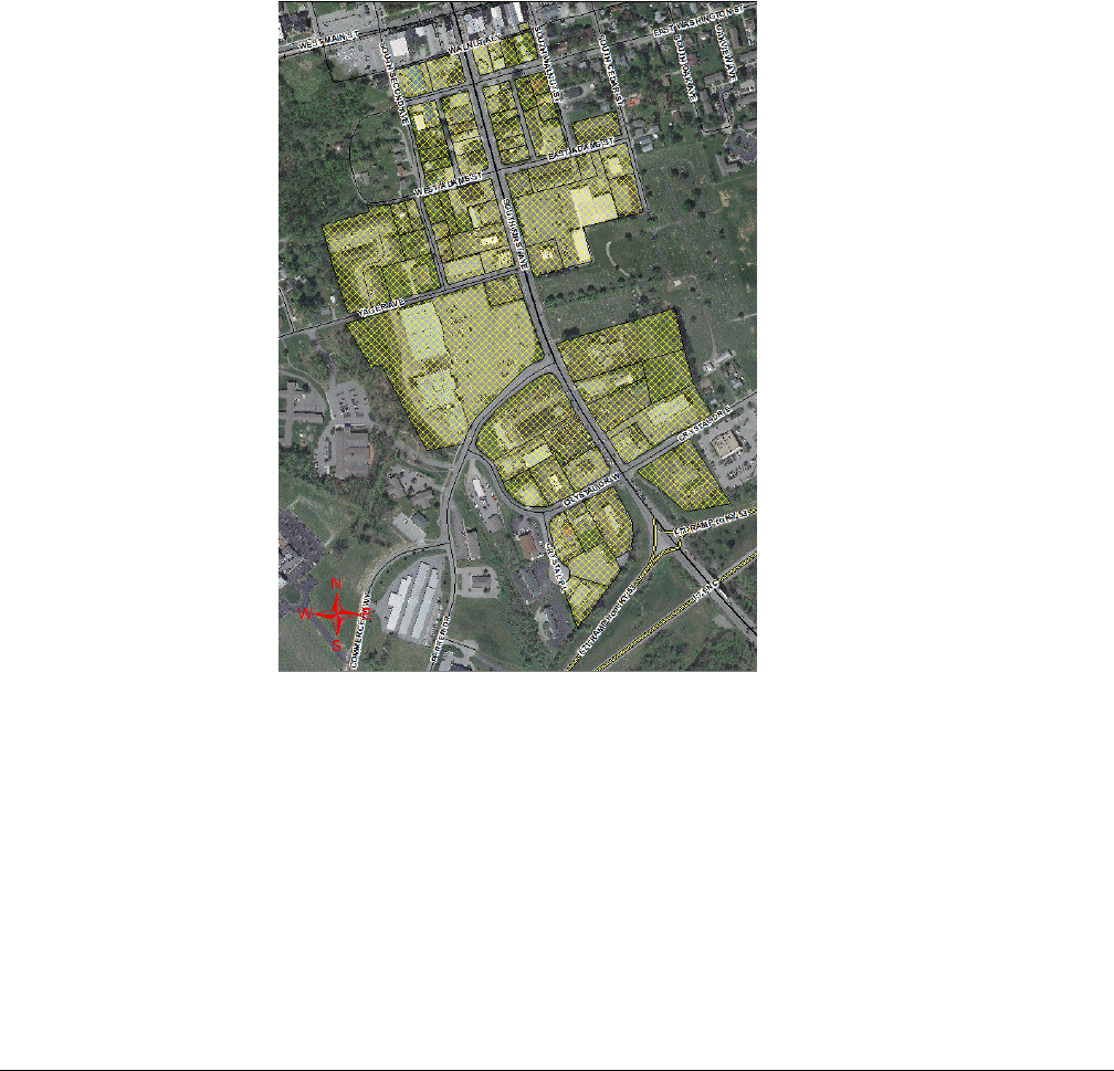
Oldham County Comprehensive Zoning Ordinance
Division 245 Highway 53 Corridor Overlay District (City of LaGrange)
84
Sec. 245-060 Site Description and Purpose
The purpose of the Overlay Ordinance is to provide a consistent development pattern within the
Highway 53 Corridor District in order to improve pedestrian mobility and connectivity, enhance
economic growth and revitalize the corridor. The standards and guidelines proposed herein only apply
to new development and re-development.
The Highway 53 Corridor Overlay, also known as South First Avenue, is bounded by Walnut Alley to
the North and I-71 to the South; stretching outward to South Cedar Street to the East and South Second
Avenue to the West. Only the back side of West Main Street bordering Walnut Alley is affected by this
ordinance; all historic district regulations for buildings included in this overlay take precedent. The
Overlap District Map is shown below:
Sec. 245-70 Exterior Lighting
Exterior light fixtures should be compatible and relate to the architectural character of the buildings on
site. Lighting should be unobtrusive and provide safe light for orderly functions.
Standards and Guidelines:
1. Decorative light fixtures, which are appropriately shielded and architecturally compatible
with structures are strongly encouraged.
2. Poles and fixtures shall be compatible with all other fixtures on site and shall be placed to
provide a unified, organized appearance throughout the development to provide even and
uniform light distribution.

Oldham County Comprehensive Zoning Ordinance
Division 245 Highway 53 Corridor Overlay District (City of LaGrange)
85
3. Lighting with a concealed light source must be of the ‘cut-off’ variety to prevent glare and
‘light trespass’ onto adjacent buildings and sites.
4. Use metal halide, incandescent or other white light fixtures. High-pressure sodium is not
allowed.
5. Provide separate, pedestrian scale lighting for all pedestrian ways.
6. Bollard light fixtures or other low-level fixtures are encouraged to identify pedestrian
walkways and drop-off areas at entrances to buildings.
7. Maximum pedestal height on all lighting is 2 feet (2’).
A. Lighting Zones:
Lighting Zones are established to guide development in constructing appropriate outdoor lighting
according to use and intensity.
(LZ-1) Lighting Zone 1: areas that necessitate low ambient lighting levels shall use pedestrian-
scaled lighting; including single and two family residential areas along with business parks and
other commercial or industrial/storage areas with limited nighttime activity.
LZ-1 Status: Parking Spaces: 49 and under OR when building is 0-60 feet from right-of-way.
Maximum height: 12 feet (12’)
(LZ-2) Lighting Zone 2: areas that necessitate moderate ambient lighting levels for higher density
or mixed use; including multifamily residential areas, institutional uses (schools, churches,
hospitals, government buildings), hotels/motels, commercial and business areas with evening
activities embedded in predominately residential areas.
LZ-2 Status: Parking Spaces: 50-149 OR when building is 61-199 feet from right-of-way.
Maximum: 16 feet (16’)
(LZ-3) Lighting Zone 3: areas that necessitate moderately high lighting levels for large commercial
and business districts; including high intensity commercial corridors, heavy industrial and
manufacturing uses, car dealerships, gas stations and other nighttime active exterior retail areas.
LZ-3 Status: Parking Spaces: 200+ OR when building is 200+ feet from right-of-way.
Maximum height: 25 feet (25’)
Sec. 245-80 Parking
Policy: Minimizing or softening parking areas is a priority as large areas of surface parking in
commercial areas discourage walking and increase parking demand by forcing people to drive between
destinations. All parking shall comply with the parking requirements set forth in Division 280 in the
Oldham County Zoning Ordinance, except as follows:
Standards and Guidelines:
1. Only one row of parking is permitted in front of the building on lots that have frontage
on KY Highway 53.

Oldham County Comprehensive Zoning Ordinance
Division 245 Highway 53 Corridor Overlay District (City of LaGrange)
86
2. Shared Parking Agreements that serve multiple businesses and land uses are encouraged
where they are likely to be achieved without conflict. See Sec. 280-140 for guidance.
3. Off-site parking is permitted where it is likely to be achieved without conflict. See Sec.
280-130.
Sec. 245-90 Landscape & Buffering
Landscaping should add to the streetscape in order to encourage pedestrian and motor vehicle mobility
while minimizing the impact of noise, dust, and other debris, motor vehicle headlight glare or other
artificial light intrusion.
Landscaping requirements shall comply with Oldham County Comprehensive Zoning Ordinance,
Division 300 including but not limited to, Secs. 300-030, 300-070, 300-080, 300-090, 300-100, 300-
110, 300-120, 200-130 and 300-140; except as follows:
Note: The Highway 53 Overlay District is excluded from the requirements in Sec. 300-050 Property
Perimeter Landscape Buffer (PPLB) Area and Plantings.
Standards and Guidelines:
1. Landscaping and walls can be combined to meet the requirements of these regulations.
2. Landscaped areas shall generally be not less than five feet (5') wide. A reduction in the
Landscape Area width may be granted if the Applicant provides architectural features to
buffer the unscreened Parking Area.
3. All plant materials proposed to meet landscaping requirements shall be living plants. See
Sec. 300-130 of the Oldham County Comprehensive Zoning Ordinance for guidance and
the Appendices of Division 300 for prohibited and approved plant lists.
4. The property owner or developer shall submit a Landscape Plan to the Commission
whenever any property is affected by these landscape requirements. See Sec. 300-140 of
the Oldham County Comprehensive Zoning Ordinance for Landscaping Plan Submission
and Approval requirements.
A. Architectural Features
Policy: Walls or bollards shall be constructed of materials that are compatible with the adjacent
building architecture and their appearance softened with landscape materials. Fences are not
permitted.
1. Height of retaining walls shall comply with the standards permitted by the County
Engineer.
2. Both sides of all perimeter walls must be similarly finished.
3. Long expanses of walls shall be broken up with periodic columns, insets, landscape
pockets or changes in materials.

Oldham County Comprehensive Zoning Ordinance
Division 245 Highway 53 Corridor Overlay District (City of LaGrange)
87
4. Walls and bollards shall be constructed from durable materials such as stone or brick, or
a similar combination of these materials.
Applicable Oldham County Zoning Ordinance Regulations:
A. Sec. 300-040 Landscape Buffer Area Requirements
Utility easements (e.g. drainage, sewer, gas/electric) are allowed to encroach into as much as 50%
of the required area of Landscape Buffer Areas provided the required screening can still be
achieved and the design of such facilities is compatible with the purpose of the Landscape Buffer
Area. For sites with an approved landscape plan, any plantings within easements that are disturbed
must be replaced and/or located as approved by the Commission staff.
B. (Sec. 300-070) Vehicular Use Area Perimeter Planting (VUAPLB)
The VUAPLB areas shall be a minimum of five feet (5’) in width with the following requirements:
Land Use
Distance of VUA
from property line is
less than or equal to
30 feet
Distance of VUA
from property line is
greater than 30 feet
and less than
50 feet
Distance of VUA
from property line is
greater than or equal
to 50 feet
VUA adjacent to any
residential use
6 foot high
continuous screen
3 foot high
continuous screen
3 foot high continuous
screen for at least 50%
of VUA
Any loading area
adjacent to any use of
lower impact
8 foot high continuous
screen
6 foot high continuous
screen
6 foot high continuous
screen only if adjacent
to residentially zoned
parcel
VUA adjacent to
rights-of-way
3 foot high
continuous screen
3 foot high
continuous screen
N/A
The 3 or 6 foot high screen requirement can be met using evergreen shrubs, evergreen trees, berms,
or walls, individually or in combination. Continuous screens may be broken or staggered for visual
interest provided the result is a visually continuous screen. See the Architectural Features section
above for specific requirements concerning walls and bollards.
C. (Sec. 300-080) Interior Landscape Areas (ILA) for Vehicular Use Areas
Interior Landscaped Areas (ILA) shall be provided within all Vehicular Use Areas to fragment
large impervious areas and allow for a greater distribution of tree canopy coverage.
1. VUAs exempt from ILA requirements are loading, unloading, and outdoor storage areas in
industrial zones I-1, I-2, IPD and the same areas in commercial zones C-N, C-1, C-2, C-3,

Oldham County Comprehensive Zoning Ordinance
Division 245 Highway 53 Corridor Overlay District (City of LaGrange)
88
C-4 when improvements create an area not accessible or visible to the general public. Note
that these areas shall be subject to both VUA and property perimeter landscape buffering.
2. Any newly created, altered or expanded VUA of 6,000 square feet or more, or to
accommodate twenty or more vehicular parking spaces, is required to have ILAs.
3. Five (5) square feet of ILA shall be provided for each one hundred (100) square feet, or
fraction thereof, of all VUA requiring ILAs.
4. The minimum ILA size in VUAs shall be one hundred fifty (150) contiguous square feet.
Note that the standard curbed area may be included in the 150 square feet. Smaller
Interior Landscape Areas are not prohibited but will not count toward ILA requirements.
5. The maximum ILA size in all VUA shall be no larger than 350 contiguous square feet in
VUAs smaller than 30,000 square feet in size. ILAs shall be no larger than 1,500
contiguous square feet in VUAs equal to or greater than 30,000 square feet in size unless
otherwise approved by the Commission or staff.
6. Note that any ILAs larger than the maximums stated above (in number 5) are
permitted provided that any ILA exceeding the maximum shall not count toward fulfilling
the requirements of this Division.
7. VUAs less than 12,000 sq. ft. in size or less than 20 parking spaces shall not have a
maximum distance between Interior Landscape Areas.
8. In VUAs of 12,000 sq. ft. or more or 20 or more parking spaces the maximum distance
between Interior Landscape Areas shall be 120 feet.
9. The maximum distance between ILAs shall be measured both radially from the closest
perimeter landscape area curb edge, and lineally in each row of parking spaces, from the
closest curb edge of each ILA.
D. (Sec. 300-090) Planting Requirements for Interior Landscape Areas (ILAs)
1. Minimum of one tree shall be required for every 250 square feet, or fraction thereof, of
required ILA. Deciduous trees shall have a clear trunk to at least six (6) feet above the
ground at time of planting.
2. The ground plane of the ILA shall be landscaped with shrubs, turf, mulch, or groundcover.
Note that shrubs shall not exceed two feet in mature height measured from the street level
in areas requiring sight distance for vehicular circulation.
3. Light poles, sidewalks, benches, or other site amenities are permitted in the ILAs provided
they do not occupy more than 25% of any one interior landscape area or reduce the width
of any planted area to less than 5 feet. Provision of such facilities does not reduce the
number of required trees.
4. In all occurrences of ILAs where vehicles overhang, the minimum distance between any
tree and edge of pavement shall be three feet.
5. Note that parked vehicles may hang over the ILA no more than two and one-half (2 ½)
feet. Wheel stops shall be provided in order to limit vehicle overhang or penetration of the
landscaped area.

Oldham County Comprehensive Zoning Ordinance
Division 245 Highway 53 Corridor Overlay District (City of LaGrange)
89
E. (Sec. 300-100) Screening Requirements for Service Structures
For the purposes of this Division, service structures shall include propane tanks, dumpsters, and
other waste containers.
1. A continuous fence or wall with opaque gate shall enclose any service structure on all sides.
The height of the fence or wall shall be one (1) foot greater than the height of the enclosed
structure, but shall not be required to exceed eight (8) feet in height. Whenever a service
structure is located next to a building wall, the wall may fulfill the screening requirement
for that side of the service structure provided that the wall or screening material is of a
height sufficient to meet the height requirement set out in this section.
Sec. 245-100 Building Design
These standards are intended to provide human-scale design while affording flexibility to use a variety
of building styles in order to protect the community character and quality of life.
Standards and Guidelines:
1. Buildings shall be pedestrian-oriented with architectural features that provide shelter from
elements and visual interest components.
2. Blank façades are prohibited facing KY Highway 53. Windows, doors, shutters, awnings,
columns, masonry detailing, and variations in the front roof line, building wall recesses
and variations in colors and materials shall be used to break up the mass of any wall. The
utility wall is excluded.
3. Each publicly visible side of the building shall have windows covering at least 15 percent
of the net façade area.
4. Drive-thrus (ordering and pay/pick-up) shall not be located in the front of a building that
abuts the right-of-way.
Sec. 245-110 Pedestrian Access
Facilities should be designed to provide internal connectivity (connectivity between adjacent/nearby
land uses) and external connectivity (connectivity between development and street/sidewalk network)
in order to promote safety, attractiveness and convenience for pedestrians of all ages and abilities.
Standards and Guidelines:
1. Safe pedestrian walkways shall be provided between sidewalks, parking areas and
storefronts.
2. All connective sidewalks must be ADA compliant with a minimum width of five feet (5’).
3. Buffers (trees, planting strips, architectural features) shall be provided between vehicles
and pedestrians.

Oldham County Comprehensive Zoning Ordinance
Division 245 Highway 53 Corridor Overlay District (City of LaGrange)
90
4. The planning department encourages the development to provide benches, trash
receptacles, bollards, and/or bicycle racks to serve the business on the right-of-way
abutting the business. The type of street furniture shall meet the uniform design standard
for the district as approved by the planning staff.
Sec. 245-120 Implementation
These regulations will be implemented during the development plan or site plan review process as part
of the technical review.

Oldham County Comprehensive Zoning Ordinance
Division 250 Special Provisions
91
DIVISION 250 SPECIAL PROVISIONS
Sec. 250-010 Special Provisions: Purpose
The purpose of this Division is to address specific land uses or conditions and set minimum standards in
order to permit proper integration of these items into the community and establish provisions for the
protection of the health, safety, and general welfare of the public and for the protection of surrounding
properties, persons, and neighborhood values.
Sec. 250-020 Applicability
The requirements set forth in this Division qualify or supplement the district requirements appearing
elsewhere in the ordinance.
Sec. 250-030 Accessory Uses and Structures (without dwelling units)
A. Agricultural Uses and Related Accessory Structure
1. Accessory structures for agricultural uses shall comply with the setback requirement for the
principal structures of the zoning district in which it is located.
2. No other sections below apply to agricultural uses or related accessory structures (e.g. barns,
stables).
B. Number of Accessory Structures
1. The number of allowed accessory structures over 120 square feet and the total maximum floor
area shall be as follows:
Size of Parcel
Total Maximum Floor Area
of Accessory Structures
Allowed
Maximum Number of
Accessory Structures Allowed
Equal to or Less than 20,000 sq. ft.
800 sq. ft.
2
20,001 sq. ft. to 0.99 acres
1,200 sq. ft.
2
1.0 acre to 2.99 acres
1,800 sq. ft.
2
3.0 acres to 5.0 acres
2,700 sq. ft.
2
5.01 acres or larger
No restriction on size
2, 3 allowed with Conditional Use
Permit
2. Conditional use permits for additional accessory structures over two (2) shall not be allowed on
parcels less than 5.0 acres.
C. Shall Follow Principle Use
No accessory use or structure may be developed until after the start of the construction of the principal
use on the building site, and no accessory use or structure may be used unless the principal use or

Oldham County Comprehensive Zoning Ordinance
Division 250 Special Provisions
92
structure has been developed except after review and approval as a Conditional Use. Accessory units
shall comply with the applicable density standards of the zoning district in which it is located.
D. Same Parcel
Except as otherwise specifically permitted elsewhere in the Zoning Ordinance, accessory uses and
structures shall be located on the same parcel as the associated principal use.
E. Relationships to Street Setbacks
No accessory use or structure shall be located in between the principal building and the front yard
property line. Accessory structures shall adhere to street-side yard setbacks.
F. Breezeway
When an accessory structure is attached to a principal building by a breezeway, roofed passage or
similar structure, it shall be deemed to be part of the principal building and shall maintain the yard
requirements of the principal building.
G. Minimum Distance Between Buildings
The minimum distance between buildings shall be five feet (5’).
H. Rear Yard Rules for Accessory Structures
1. All accessory structures shall be set back from the rear and side property lines a minimum of
five feet (5’).
2. Accessory structures shall not occupy more than thirty-five percent (35%) of the area between
the rear property line and the principal structure.
Sec. 250-040 Accessory Dwelling Units
A. Definitions
Accessory Dwelling Unit – A living unit located on a residential lot with a primary unit/structure
subordinate in scale and use to the primary unit/structure.
Interior Accessory Dwelling Unit – An accessory dwelling unit created and contained within the
footprint of an existing or new house.
Attached Accessory Dwelling Unit – An accessory dwelling unit which is added to the floor area of
an existing house.
Detached Accessory Dwelling Unit – An accessory dwelling unit that is separate from the primary
dwelling unit.
Breezeway - A covered walkway open on all sides from the eaves of the roof to the ground, connecting
a main structure with an accessory structure on the same building site and designed to minimally

Oldham County Comprehensive Zoning Ordinance
Division 250 Special Provisions
93
maintain the architectural design, style, appearance and character of the primary structure. Maximum
length of breezeway is twenty (20) feet.
B. General Provisions
1. Only one accessory dwelling unit is allowed per parcel.
2. The property owner must reside in either the primary structure or the accessory dwelling unit.
At the time of application for a building permit, the property owner will be required to complete
and sign an accessory dwelling unit affidavit.
3. Interior Accessory Dwelling Units and Attached Accessory Dwelling Units shall not count
toward density calculations (0.0) and Detached Accessory Dwelling Units will count as a
whole unit (1.0) toward density calculations.
4. Off-street parking must be provided for the accessory dwelling unit.
5. Accessory dwelling units must be designed to maintain the architectural design, style,
appearance and character of the primary structure.
6. Accessory dwelling units shall not have separate utility services from that of the primary
structure unless necessary to meet building or electrical codes; or required by service provider.
7. Accessory dwelling units shall not be allowed on non-conforming parcels or in non-
conforming structures.
8. Accessory dwelling units shall not violate any deed restrictions or covenants, conditions and
restrictions associated with the property.
9. Accessory dwelling units shall comply with all applicable building codes, health department
regulations and all other necessary permitting.
C. Interior Accessory Dwelling Units
1. Interior Accessory Dwelling Units shall be allowed by right in the AG-1, CO-1, R-1, R-1A, R-
2, and R-2A zoning districts with an approved building permit if all conditions are met.
2. Interior Accessory Dwelling Units must have a permanent interior connection to the primary
living area of the primary structure.
D. Attached Accessory Dwelling Units
1. Attached Accessory Dwelling Units shall be allowed by right in the AG-1, CO-1, R-1, R-2,
and R-2A zoning districts with an approved building permit if all conditions are met.
2. Attached Accessory Dwelling Units shall meet the minimum setbacks for primary structures.
3. Attached Accessory Dwelling Units shall not exceed 30 percent of the primary structure’s
finished square footage.
4. Attached Accessory Dwelling Units shall not exceed the height of the primary structure.
5. Attached Accessory Dwelling Units shall have a permanent interior connection through a
common wall to the primary structure (breezeways are not considered a connection).
E. Detached Accessory Dwelling Units
1. Detached Accessory Dwelling Units may be allowed only after approval of a Conditional Use

Oldham County Comprehensive Zoning Ordinance
Division 250 Special Provisions
94
Permit.
2. Detached Accessory Dwelling Units shall be allowed in the AG-1, CO-1, R-1, R-1A, R-2,
and R-2A zoning districts only upon granting of a Conditional Use Permit.
3. Detached Accessory Dwelling Units will count as a whole unit (1.0) toward density
calculations.
4. Detached Accessory Dwelling Units shall meet the minimum setbacks for primary structures.
5. Detached Accessory Dwelling Units shall not exceed 25 percent of the primary structure’s
square footage.
6. Detached Accessory Dwelling Units must be at least five (5) feet from the primary structure.
7. Detached Accessory Dwelling Units shall not exceed the height of the primary structure.
8. Detached Accessory Dwelling Units shall not be located in front of the primary structure.
F. Variances
1. Upon application, the Board of Adjustments may grant variances from these regulations.
Sec. 250-045 Accessory Service and Retail Uses
An accessory use is a use customarily incidental and subordinate to the principal use or building and
located on the same lot with such principal use or building. Accessory service and retail uses serving at
least seventy-five percent (75%) of the residents, clients or employees of the principal use with which
they are associated shall be permitted in accordance with the following requirements:
A. Location
The accessory service or accessory retail use shall be located inside the building occupied by the same
principal use. Access may be from either the interior or exterior of the building which is occupied by
the accessory service or retail use.
B. Maximum Floor Area Ratio
The total floor area occupied by all accessory service or accessory retail uses shall not exceed ten
percent (10%) of the floor area of the development site; nor, shall such uses occupy more than twenty-
five percent (25%) of the floor area of any single building.
C. Specific Accessory Service Uses
1. Banks/Financial Institutions: Banks and financial institutions with drive-thru facilities are a
principal use and shall not be permitted as an accessory service use.
2. Drive-in Facilities: Drive-in facilities shall not be permitted in connection with any accessory
service use.
3. Eating and Drinking Establishments: Eating and drinking establishments shall be permitted as
an accessory service use in the IPD only if the establishment is located internally within the
building site.
4. Outdoor Display or Storage: Outdoor display or storage of merchandise shall not be permitted
as a part of an accessory service or retail use.

Oldham County Comprehensive Zoning Ordinance
Division 250 Special Provisions
95
5. Identification Signs: Exterior identification signs in addition to sign regulations for primary
use should be no larger than six (6) square feet.
Sec. 250-050 Short Term Rental Propery
A. Definitions
Boarding house- means a residential facility or a portion of a residential dwelling unit for the
temporary accommodation of persons or families in a rooming unit, whether for compensation or
not, who are in need of shared lodging and personal services, supervision, or rehabilitative services.
Commercial establishment- an establishment used for the conduct of a business.
Host- Any person who is the owner of record of residential real property, or any person who is a
lessee of residential real property pursuant to a written agreement for the lease of such real property,
who offers a dwelling unit, or portion thereof, for short term rental.
Hotel- any commercial establishment, or any portion of such establishment, (A) whose principal use
provides that such structure is occupied or intended or designed for occupancy by transients for
lodging or sleeping purposes and includes any hotel, inn, tourist court, tourist camp, tourist cabin,
motel or any place meeting this definition, and (B) accepts on-site reservations for
accommodations.
Not Owner-Occupied-owner of the property does not permanently reside in the STRP or in the
principal residential unit which the STRP is associated on the same lot.
Owner-Occupied- owner of the property permanently resides in the STRP or in the principal
residential unit with which the STRP is associated on the same lot.
Responsible Party- a person or business residing or located within twenty-five (25) miles of the
STRP that is responsible for addressing all maintenance and safety concerns.
Short Term Rental Property (STRP) - a residential dwelling unit that is used and/or advertised for
rent for transient occupancy by guests. Dwelling units rented to the same occupant for more than 30
continuous days, Bed and Breakfast establishments, boarding houses, hotels, and motels shall not be
considered Short Term Rental Property.
Transient- any person who exercises occupancy or is entitled to occupancy of any rooms, lodgings or
accommodations for a period of less than thirty (30) continuous days.
B. General Provisions
1. In zoning districts in which Residential Uses are a Permitted Use, including legal non-
conforming residential uses, a short term rental of the dwelling unit that is the primary
residence of the property owner is permitted by the Planning Director with special standards
set forth in this section.
2. In zoning districts in which Residential Uses are a Permitted Use, including legal non-
conforming residential uses, a short term rental of the dwelling unit that is not the primary

Oldham County Comprehensive Zoning Ordinance
Division 250 Special Provisions
96
residence of the property owner is required to obtain a Conditional Use Permit by the
appropriate Board of Adjustments. If granted the CUP the owner must also comply with the
special standards set forth in this section.
3. Multi-family apartments or condominium applicants must be either the owner of the property
or the lessee. If the applicant is the lessee, the application must be accompanied by signed
documentation of permission from the lessor for the operation of the short term rental at the
subject property. If the short term rental is not primary residence of the owner or lessee they
will be required to obtain a Conditional Use Permit by the appropriate Board of Adjustments.
If granted the CUP the owner must also comply with the special standards set forth in this
section.
4.
5. No person or entity shall operate a STRP or advertise a residential property for use as a STRP
without the owner of the property first having obtained a STRP permit issued by Planning &
Development in accordance with the provisions of this section.
6. Any advertising or description of a STRP on any internet website must: (a) prominently display
the permit number for the STRP unit; or (b) include an image of the permit, or a link to an
image of the permit, in which the permit number is legible.
7. Outdoor signage which identifies the short term rental is prohibited.
8. There shall be a sufficient parking available for the host and guests and shall not create a
demand for parking.
9. No food shall be prepared for or served to the transient by the permit holder.
10. The principal renter of a STRP unit shall be at least twenty-one (21) years of age.
11. The maximum number of occupants permitted on a STRP property at any one time shall not
exceed more than twice the number of sleeping rooms plus four. The occupancy maximum
shall be conspicuously posted within the STRP unit. Advertising a STRP for more occupants
than allowed by this regulation shall be grounds for revocation of the permit.
12. Simultaneous rental of a STRP to more than one party under separate contracts shall not be
allowed.
13. The maximum stay for any guest shall be thirty consecutive days.
14. The name and telephone number of the local responsible party (who shall reside or be located
within twenty-five (25) miles of the STRP) shall be conspicuously posted within the STRP
unit. The responsible party shall answer calls twenty-four hours a day, seven days a week for
the duration of each short term rental period to address problems associated with the STRP.
15. A clearly marked evacuation plan is posted on the premises.
16. The permit holder shall be responsible for maintaining proper insurance coverage on the STRP.
17. The permit holder shall be responsible for collecting and remitting all applicable room,
occupancy, and sales tax required by state law and Oldham County.
18. Each short term rental shall be in compliance with any currently applicable laws and
regulations of the federal, state, or local governments, as may be amended from time to time
including but not limited to, laws or regulations on nondiscrimination, zoning, building, safety,
property maintenance, health and sanitation, fire, electrical, plumbing, mechanical, and other

Oldham County Comprehensive Zoning Ordinance
Division 250 Special Provisions
97
applicable laws.
C. Application
The STRP permit application shall verify by affidavit that all of the information being provided is true
and accurate and the application shall include the following information:
1. The name, telephone number, address, and email address of the owner, host and of a person or
business ("responsible party") residing or located within twenty-five (25) miles of the STRP
that is responsible for addressing all maintenance and safety concerns;
2. Owners applying for an owner-occupied permit must provide two documents giving proof of
owner occupancy. Acceptable documentation includes Kentucky Driver's license, other valid
State of Kentucky identification card, Oldham County voter registration card, utility bills,
paycheck/check stub, work ID or badge, or a bank statement, each current and showing the
owner's name and address matching that of the property to be utilized for short term rental.
3. A floor plan of the residence showing number of bedrooms and location of smoke alarms.
The floor plan can be hand-sketched (number of sleeping rooms will be checked against the
tax assessor’s record). Floor Plans shall show details of all levels of the house and any attached
structures, location of windows, doors (interior and exterior), and locations of the required
smoke detectors.
4. A statement that the applicant has confirmed that operating the proposed STRP would not
violate any Home Owners Association agreement or bylaws, Condominium Agreement,
Covenants, Codes and Restrictions or any other agreement governing and limiting the use of
the proposed STRP property
D. Expiration and renewal of permit.
No person, firm, or corporation shall own or operate a short term rental on any premises within Oldham
County unless the short term rental has been registered annually with Planning & Development. All
STRP permits shall expire on December 31st of each calendar year and is the responsibility of the
owner to renew the permit.
1. Renewal applications shall include at minimum:
(1) payment of renewal fee; and
(2) a statement verified by affidavit that:
(a) includes all of the information required in an application under Item C and
(b) the STRP continues to be in full compliance with all applicable laws, including the
payment of all applicable taxes.
2. A STRP permit shall not be transferred or assigned to another individual, person, entity, or
address, nor shall the permit authorize any person, other than the person named therein, to
operate a STRP on the property.
E. Denial or Revocation of Permit.
Upon the filing of a complaint regarding a STRP permit, the Code Enforcement Officer shall notify
the permit holder in writing or by e-mail of such complaint and follow the process as outline in the
Oldham County Nuisance Ordinance.

Oldham County Comprehensive Zoning Ordinance
Division 250 Special Provisions
98
If the property is subject to two (2) or more substantiated civil and/or criminal complaints, the Planning
Director may revoke the approval. Any denial or revocation of a STRP permit may be appealed to the
appropriate Board of Adjustments as an administrative appeal.
If the property insurance coverage lapses, Oldham County Planning & Development shall have the
right to revoke permit. Once a STRP permit has been revoked, no new permit shall be issued to the
applicant for the same property for a period of one year.
Sec. 250-055 Adjacent to Residential Standards
Whenever non-residential zoned property is adjacent to residential zoned property, the residential setbacks
apply to the non-residential property. Any adjacent site less than two hundred (200) feet in width shall
follow the residential setbacks. Any adjacent site greater than two hundred (200) feet in width shall only
be required to follow the residential setbacks for the two hundred (200) feet that is adjacent to the
residential area.
Sec. 250-060 Adult Entertainment
A. Purpose
The regulations established herein are intended to ensure that the adverse effects created by adult
entertainment establishments are minimized and controlled so as not to cause or contribute to
crime, increasing blight, or downgrading of adjacent property and the surrounding neighborhood
by restricting their proximity to Public Parks, schools, hospitals, churches, certain governmental
and civic facilities, and scenic corridors.
The regulations established herein are intended to protect and preserve the quality, property
values, integrity and character of the county’s neighborhoods and commercial districts, deter
blight, and protect the citizens of Oldham County from the adverse effects of adult entertainment
establishments.
The provisions of this Section are not intended to impose a limitation or restriction on the content
of any communicative materials, nor to restrict or deny access by adults to sexually oriented
materials protected by the First Amendment to the Constitution of the United States, nor to
deny access by distributors and exhibitors of sexually- oriented entertainment to their intended
market.
B. Uses Regulated
Uses regulated by the provisions of this Section shall hereinafter be designated as adult
entertainment establishments and shall be further defined as follows:
1. An adult entertainment establishment shall be defined as any commercial establishment open
to the public which displays, distributes, issues, gives, provides, lends, transfers, transmits,
circulates, disseminates, presents, exhibits, advertises, sells, rents or leases a substantial or

Oldham County Comprehensive Zoning Ordinance
Division 250 Special Provisions
99
significant portion of its stock in trade, or is characterized by the depiction of ‘specified
anatomical areas’ or ‘specified sexual activities’ as such are herin defined.
2. Any commercial establishment open to the general public which involves employees or
customers who engage in conduct which is distinguished or characterized by ‘specified sexual
activities’ or ‘specified anatomical areas’ as herein defined.
Adult Entertainment establishments specifically identified and regulated by the provisions of this
Section shall include, but not necessarily limited to:
Adult Book Stores
Adult Motion Picture Theaters
Adult Motion Picture Arcades
Adult Entertainment Cabarets
Adult Hotels
Massage Parlors.
C. Location and Distance
Permitted Zoning Districts: An adult entertainment establishment located within the County limits
shall be allowed only in C-1, C-2, C-3, C-4, I-1, I-2, or IPD Zoning Districts subject to the
following limitations:
1. An adult entertainment establishment shall not be permitted or enlarged, except by a
governmental agency within:
a. Two thousand (2,000) feet of a preexisting adult entertainment establishment;
b. Two thousand (2,000) feet of a preexisting religious institution;
c. Two thousand (2,000) feet of a preexisting educational institution;
d. Two thousand (2,000) feet of a preexisting hospital or government/civic facility;
e. One half mile of a preexisting interstate; or
f. Two thousand (2,000) feet of a preexisting scenic corridor; or
g. One thousand (1,000) feet of a preexisting park; or
h. Five hundred (500) feet of a preexisting commercial establishment that in any manner
sells or dispenses alcohol for on-premises consumption.
2. The distance from a proposed or existing adult entertainment establishment to a preexisting
adult entertainment establishment, a preexisting religious institution, a preexisting educational
institution, a preexisting hospital or governmental and civic facility, a preexisting interstate, a
preexisting scenic corridor, a preexisting park, or a preexisting commercial establishment that
sells or dispenses alcohol for on-premises consumption shall be measured by drawing a straight
line between the closest property lines of the proposed or existing adult entertainment
establishment and the preexisting adult entertainment establishment, a preexisting religious
institution, a preexisting educational institution, a preexisting hospital or governmental and
civic facility, a preexisting interstate, a preexisting scenic corridor, a preexisting park, or a
preexisting commercial establishment that sells or dispenses alcohol for on-premises
consumption.

Oldham County Comprehensive Zoning Ordinance
Division 250 Special Provisions
100
D. Development Plan Requirements
1. A development plan must be submitted and shall include, but not be limited to, access, parking,
signage, landscaping, dumpster location, and justification that the adult entertainment use is
not located within the distance setbacks.
2. The development plan shall be submitted to the Oldham County Planning and Zoning Office
for review of the proposed development. Staff will review and approve, approve with
exceptions noted, or deny the development plan within sixty (60) calender days.
3. The staff shall not be required to approve a development plan if the staff has reason to question
its accuracy or its compliance with this adult entertainment regulation, to zoning regulation or
any other regulations. Staff shall refer any such issues to the full Planning Commission.
Reasons for denial of the development plan shall be stated in writing.
4. Final approval or denial of the development plan by staff or by the full Planning Commission
may be appealed to the Oldham Circuit Court pursuant to KRS 100.347(2).
5. Parking Standards: The minimum and maximum number of parking spaces required/allowed
is outlined in the table below:
M
i
n
imum
Maximum
Live Adult
Entertainment
Establishment
1.0 space for each 150 sq.
ft. of gross floor area
1.0 space for each 75 sq. ft.
of gross floor area
Adult Retail
Establishment
1.0 space for each 275 sq.
ft. of gross floor area
1.0 space for each 175 sq.
ft. of gross floor area
6. Landscaping Standards: Landscaping shall be provided on the premises of any adult
entertainment establishment to screen and buffer the adjoining uses.
7. Signage Standards: Exterior signs located on the building of an adult entertainment
establishment shall conform to the requirements of Division 290 of the Oldham County
Comprehensive Zoning Ordinance, otherwise known as the Sign Regulation/ Such exterior
signs shall not advertise, either graphically or verbally, either by explicit or literal expression,
connotation, or implied reference any ‘specified sexual activity’ or ‘specified anatomical area’
as herein defined. There shall be no electronic reader boards or changing messag center signs.
No display of goods, product, or services shall be visible from outside the building.
8. Freestanding Building: An adult entertainment establishment shall be located in a freestanding
building, containing no other uses or adult entertainment establishments.
9. All adult entertainment facilities shall have façades, exteriors and exits which must be
indistinguishable from surrounding buildings. Illustrations depicting males and/or females
shall not be posted or painted on any exterior wall of the building used for such businesses or
on any door or apparatus attached to such building.
E. Hours of Business
An adult entertainment establishment shall not be permitted to allow such establishment to remain
open for business or to permit any worker to engage in a performance, solicit a performance, make

Oldham County Comprehensive Zoning Ordinance
Division 250 Special Provisions
101
a sale, solicit a sale, provide a service, or solicit a service between the hours of one o’clock (1:00)
a.m. and eleven o’clock (11:00) a.m. of any particular day.
A worker of an adult entertainment establishment shall not be permitted to engage in a
performance, solicit a performance, make a sale, solicit a sale, provide a service, or solicit a service
between the hours of one o’clock (1:00) a.m. and eleven o’clock (11:00) a.m. of any particular
day.
F. License Requirement
An adult entertainment establishment shall obtain any license which may be required by the
applicable government agency after adoption of this regulation.
G. Age Requirement
Adult entertainment establishments shall not employ nor permit entry of minors (17 years of age
and under).
H. Definitions
The definition of adult entertainment establishment and the provisions of this Section shall apply
to the opening or commencement of a new business, the conversion of an existing business to any
sexually- oriented business, the addition to, or expansion of, an existing adult entertainment
establishment or the relocation of any adult entertainment establishment.
Adult Book Store
A person, establishment or business having more than a
minimal portion of its stock in trade, such as recordings, books, magazines,
periodical films, video tapes/cassettes or other reading or viewing materials
for sale or viewing at the premises, materials which are distinguished or
characterized by their emphasis on matters depicting, describing or relating to
specific or general sexual activities or anatomical areas; or an establishment
with a section devoted to the sale or display or viewing of such materials.
Adult Motion Picture
Theater
A structure, either indoors or outdoors, used for
showing, displaying or presenting to patrons therein or thereat materials
distinguished and characterized by emphasis on depicting, describing or
relating to specific or general sexual activities or specific anatomical areas.
Adult Motion Picture
Arcade
Any place to which the public is permitted or invited wherein coin or slug-
operated or electronically, electrically, mechanically or otherwise controlled
still or motion picture machines, projectors or other image- producing devices
are maintained to show images to any one person at any machine at any time
so displayed as to distinguish or characterize by emphasis on depicting or
describing specific sexual activities or
specific
anatomical areas.

Oldham County Comprehensive Zoning Ordinance
Division 250 Special Provisions
102
Adult Entertainment
Cabaret
A public or private establishment which is licensed to serve food and/or
alcoholic beverages and which features topless and/or bottomless dancers,
strippers, male or female impersonators or similar entertainers, or employees
appearing in a bottomless and/or topless manner of dress.
Adult Hotel
A hotel or motel wherein a substantial or significant portion of the
material presented over image-producing devices within individual rooms
that are occupied by guests are distinguished or characterized by an
emphasis or matter depicting or describing ‘specified sexual activities’ or
‘specified anatomical areas’.
Massage Parlor
An establishment having a place of business where any
person, firm, association, or corporation engages in, carries on, or permits to
be engaged in or carried on any of the following activities:
1. Any method of pressure on or friction against or stroking, kneading,
rubbing, tapping, pounding, vibrating, or stimulating of the external soft parts
of the human body with the hands or with the aid of any mechanical or
electrical apparatus or device, with or without supplementary aids such as
rubbing alcohol, antiseptics, oils, powders, creams, lotions, ointments, or
others similar preparations.
2. The term “Massage Parlor” shall not apply to licensed hospitals,
licensed nursing homes, or clinics or persons holding an un-revoked
certificate to practice under the laws of the State of Kentucky.
Specified Anatomical
Areas
Less than completely covered human genitals, pubic regions, buttocks, and
female breasts below a point immediately above the top of the areola, and the
human male genitals in a discernible turgid state.
Specified Sexual
Activities
(a) human male genitals in a state of sexual stimulation or arousal; (b) ultimate
sex acts normal or perverted, actual or simulated, including acts of human
masturbation, sexual intercourse, oral copulation or sodomy, and (c) fondling
or other erotic touching of human or animal genitals, pubic regions, buttocks or
female breasts.
Sec. 250-070 Attached Single-Family Structures
A variety of dwelling types is encouraged throughout the Oldham County Comprehensive Plan. This type
of housing structure is intended for the R-4A Residential District. The following provisions, along with
R-4A, apply to single-family attached residential structures.
1. Open Space: The amount of open space required shall be two hundred fifty (250) square feet per
dwelling unit excluding yard setbacks, easements, etc.
2. Grouping of Units: No more than four (4) single family attached units shall be included in any one
contiguous grouping. Building shall be considered contiguous if any portion of wall or any unit is
common with any portion of any wall of another unit.
3. Setbacks: There is no side setback requirement for the interior units of an attached single family
dwelling structure. The front and rear setback requirements are the same as the detached setbacks

Oldham County Comprehensive Zoning Ordinance
Division 250 Special Provisions
103
in the R-4A zoning district. The end units must observe a ten foot (10’) side setback. The street-
side setback for the applicable zoning district shall apply to all end units located on corner lots.
Sec. 250-075 Residential Care Facilities
Any sponsoring private or governmental agency shall be permitted to operate a residential care facility in
any residential district, zone, or subdivision subject only to compliance with the same limitations upon
area, height, yard, screening, parking, number of dwelling units, and number of occupants per dwelling
unit as apply to other residences in the district, zone, or subdivision. For purposes of determining the
number of occupants in a residential care facility, or in any of the dwelling units which comprise the
facility, employees of the sponsoring agency providing services to persons with disabilities shall be
counted only if their permanent residence is maintained at the facility. No conditional use permit not
otherwise required for other residences within a zone or land use category shall be required for the
operation of a residential care facility. (Per KRS 100.984 Residential care facility for persons with
disabilities.)
Sec. 250-080 Qualified Manufactured Homes
Qualified Manufactured Homes may be placed on a lot zoned for residential use in accordance with
applicable zoning district requirements and provided that the standards of this section are met.
A Qualified Manufactured Home means a manufactured home meets all of the following criteria:
1. Is manufactured on or after July 15, 2002.
2. Is affixed to a permanent foundation and is connected to the appropriate facilities and is installed
in compliance with KRS 227.570.
3. Has a width of at least twenty feet (20’) at its smallest width measurement or is two (2) stories in
height and oriented on the lot or parcel so that its main entrance door faces the street.
4. Has a minimum total living area of nine hundered (900) square feet (Qualified manufactured
homes less than 900 square feet living area are subject to a conditional use permit).
5. Is not located in a manufactured home land-lease community.
The following additional standards shall also be applicable to all Qualified Manufactured Homes:
1. Exterior material shall be material customarily used on-site built dwellings, such as board siding,
plywood or pressed wood siding, non-glossy vinyl siding, stucco, brick, or non-reflective
aluminum.
2. Roofing material shall be wood, tile, composition shings or sheet metal, and must have an eave
projection of no less than six inches (6’). Roof pitch must be at least a four-to-twelve ratio (4:12).
3. Exterior covering material extending from the roofline to the ground or to the top of the foundation
shall be used. Masonry type skirting shall be constructed from the ground to the bottom of the
exterior wall.
4. Stuctural additions or alterations shall be subject to the same building code regulations as apply to
additions or alterations to a conventionally built house. Any other alteration or conversion of a
Qualified Manufactured Home must be performed in accordance with KRS 227.550 et seq., 815

Oldham County Comprehensive Zoning Ordinance
Division 250 Special Provisions
104
KAR 25:050, Section 2 and 42 USC Chapter 70.
5. If located in a preservation district, additional standards may apply.
Sec. 250-090 Fences and Walls
1. Fences and walls in the R-1, R-1A. R-2, R-2A. R-3. R-4 and R-4A districts:
a. Required front and street side yards may be occuposed by an ornamental fence or wall not to
exceed three-and-one-half feet (3 ½’) in height except as provided in Section 330-040 (Sight
Triangle).
b. Required side and rear yards may be occupied by an ornamental fence or wall not to exceed
seven feet (7’) in height.
c. In all other districts these requirements shall apply when the district abuts a residential district.
d. See Section 250-170 Swimming Pools, Hot Tubs and Hydro Spas, numbers two and three, for
fencing and exterior access requirements.
Sec. 250-100 Fuel Sales and Vehicle-Repair
1. Fuel Pumps: All fuel pumps including liquefied petroleum retail sales storage tanks and necessary
dispensing apparatus shall be located at least fifeteen feet (15’) from the rights-of-way line.
2. Groundwater Contamination: Federal and State groundwater contamination standards shall be
deemed a part of this Section.
3. Driveway Width Requirements: Fuel sales and vehicle sales service stations require wider
driveways than other uses; however, proper traffic control requires that such driveway widths not
be excessive. Driveway widths for these uses shall therefore conform to the following
requirements:
Maximum Width – thirty six (36’) feet
Minimum Width – twenty four (24’) feet
Sec 250-110 Land Use for Agricultural Purposes
Pursuant to KRS 100 (refers to the definition of agricultural uses), any land which is used for agricultural
purposes exclusive of land and buildings used for residents, shall have no regulations except that:
1. Setback lines shall be required for the protection of existing and proposed streets and highways as
required for the zone in which the use is located.
2. That all buildings or structures in a designed floodway or floodplain or which tent to increase food
heights or obstruct the flow of flood waters shall be in accordance with this ordinance.
3. All dwellings to be constructed or provided as part of land use for agricultural purposes shall meet
all requirements of the zone in which said use is located and shall meet all other requirements of
this ordinance.
Sec. 250-130 Manufactured Homes Supporting Agriculture Uses
Manufactured home(s) can be located on a lot of five acres or larger and used for agricultural purposes.
The manufactured home(s) shall comply with the setback and density requirements of the underlying
zoning district. These manufactured home(s) shall be used only for the workers who are employed at the

Oldham County Comprehensive Zoning Ordinance
Division 250 Special Provisions
105
farm or their family members. No other building or structure shall be attached to the manufactured
home(s).
Sec. 250-140 Outdoor Sales, Storage, or Display
The intent of this Section is to provide for the appropriate location and design of outdoor sales, storage,
and display areas and to minimize the visual impacts to adjacent properties and public rights-of-way. This
Section applies to all residential, commercial, and industrial development in all zones that propose outdoor
storage or display.
Outdoor storage, sale, or display of merchandise, material, and equipment is permitted in residential,
commercial, and industrial zones only when incidental to an allowed use located on the same premises
provided the following criteria are met.
A. Outdoor Sale, Storage, or Display Standards
1. Outdoor sale, storage, or display of merchandise, material, or equipment is subject to all
applicable fire, health, safety, and building regulations.
2. Outdoor sale, storage, or display of merchandise, material, or equipment shall not impede the
growth or maintenance of required landscaping.
3. The area designed for outdoor sale, storage, or display of merchandise, material, or equipment
for sale, storage, or display shall be on private property and not allowed in areas set aside,
required, or designed for driving aisles, driveways, maneuvering areas, emergency access
ways, vehicular parking areas, landscape areas, sight distance triangles, front and street-side
yards, or centerline setbacks.
4. Outdoor sale, storage, or display of merchandise, material, or equipment shall be completely
screened from view of residentially zoned or used property and rights-of-way by solid fences,
walls, buildings, or landscape features, or by a combination of screening elements. No
merchandise, material, or equipment shall exceed the height of the screening fence, wall, or
building. A property shall not be considered residentially used if the first floor is occupied by
a nonresidential use or uses.
5. Present use of home maintenance equipment and non-motorized recreational and leisure
equipment in residential zones are excluded from this Section.
B. Outdoor Storage Standards
1. All outdoor storage areas shall be screened from view by solid fences, walls, or buildings, or a
combination thereof, not less than 6 feet in height. If screening of the merchandise, material,
or equipment requires a screening height greater than 6 feet, the storage area and the screening
fences, walls, or buildings shall be located on the rear half of the lot, away from any rights-of-
way.
2. Outdoor storage shall not occur within 25 feet of any right-of-way.
C. Outdoor Sales or Display Standards

Oldham County Comprehensive Zoning Ordinance
Division 250 Special Provisions
106
1. Outdoor sales and display may be permitted within an area not greater than 800 square feet or
10% of the ground floor area of the building, whichever is greater.
2. The following merchandise, if for sale or rent on the premises, may be displayed outdoors
during hours of business operation without screening fences or walls except along property
lines that abut residential zones or uses.
a. Vending and ice machines
b. Food products
c. Retail operations that occur under a permanent canopy structure
d. Any other merchandise that the Administrator finds to be similar in character, type,
or nature to the merchandise listed above, and which will not cause adverse visual impacts to
the neighborhood.
3. Merchandise that is for sale on the premises that is not listed in this Section may be displayed
outdoors during hours of business operation provided that the display area is screened by
fences, walls, buildings, landscape screening, or any combination thereof.
4. Temporary displays of merchandise, material, or equipment that is for sale on the premises
may be permitted without screening fences, walls, or buildings for up to 30 calendar days in
any twelve-month period.
Sec. 250-150 Public Utility Buildings and Facilities (not including utility pedestals and junction
boxes)
1. All buildings and structures shall observe the front, street side, and rear yard requirements of the
district.
2. All buildings and structures shall be at least 20 feet from a side property line.
3. In instances where additional height is neede above the maximum height in the district, one foot
shall be added to all yards for each story (or 10 feet) of building or structure over the allowed
height.
4. Drives and parking areas shall be concrete, asphalt or paver blocks.
5. All facilities shall be landscaped and when near residential areas, shall be buffered per Division
300.
Sec. 250-160 Refuse Disposal Containers for Uses Other than Single-Family Residential
1. Location: No refuse container shall be located in any required vehicular use area, buffer, landscape
area, or setbacks. All refuse disposal containers are specifically prohibited in any required yards.
2. Screening: All refuse containers shall be opaquely screened from view from public strets and
adjacent properties to a height of at least 6 feet, or 6 inches higher than the height of the container,
whichever is higher. This screening may be achieved by walls, landscaping, buffer yards, or by
virtue of the location of the container on the building site.
Sec. 250-170 Swimming Pools, Hot Tubs and Hydro Spas
1. Location: A private single-family swimming pool may be constructed in or on the required rear
yard, in excess of the maximum coverage of 35% by accessory buildings over 120 feet, provided

Oldham County Comprehensive Zoning Ordinance
Division 250 Special Provisions
107
that such pool shall be no closer than 5 feet to any property line, and also is enclosed by a fence or
other protective device at least four (4) feet in height prior to its use. No swimming pools shall be
constructed or erected without a required permit. Any buildings or structures in conjunction with
a pool shall be classified as accessory buildings unless they are part of the main building.
Swimming pools, hot tubs, and hydro spas shall be located behind the principal structure on the
same lot and shall not be placed in any areas identified as required on- site subsurface sewage
disposal system repair areas by the Oldham County Health Department.
2. Fencing: Any artificial swimming pool of any type of whatsoever, including but not limited to
portable swimming pools, constructed in such a manner as to permit a water depth of two (2) feet
or more and an area of 250 square feet or more shall be completely enclosed by a fence, wall, or
an equivalent barrier of a minimum height of 48 inches. Enclosure fences shall be constructed so
as to prohibit the passage of a sphere larger than 4 inches in diameter through any opening
or under the fence. Above ground pools with a vertical barrier of at least 48 inches are not
required to have fences. However, above ground pools must have a retractable ladder or locking
gate to the steps of a side deck.
3. Exterior access: Exterior access to pools must be through a self-latching gate with latches placed
at least 4 feet above the ground and operable from the interior of the swimming pool area only. All
gates opening through such enclosure shall be kept securely closed and latched at all times.
Sec. 250-180 Temporary Uses and Events
Manufactured Home Used as Temporary Shelter: When a house needs to be built, rebuilt or rehabilitated
due to fire, natural disaster or other reasons, a temporary use of a manufactured home located on the parcel
during construction is permitted to the following additional regulations:
1. A temporary use permit shall be required.
2. Required water and sanitary facilities must be provided.
3. The manufactured home must bear either a HUD Label or a B1 Seal.
4. The maximum length of a permit shall be 12 months, but the Administrator may extend the permit
for a long period or periods not to exceed 3 months each provided reasonable construction progress
has been made and such construction is being diligently pursued. Application for the extension
shall be made at least 15 days prior to the expiration of the permit.
5. The manufactured home shall be removed within 30 days from the property upon issuance of any
occupancy permit for the new or rehabilitated residence. The applicant shall agree and authorize
the Administrator to remove the shelter at the applican’ts expense upon termination of the permit
if the applicant has not done so voluntarily.
Sec. 250-190 Tennis Courts
1. Lighting: Lighting of exterior tennis courts shall be directed away from adjacent properties and
shall be in compliance with the lighting standards found in Section 240-200 of this ordinance.
2. Relationship to Street Setbacks: No tennis court on a residential building lot shall be located in
between the principal building and the front yard property line.

Oldham County Comprehensive Zoning Ordinance
Division 250 Special Provisions
108
Sec. 250-200 Scenic Corridors
Purpose
To create the basis for visual character within and along certain primary arterials identified in the Major
Thoroughfare Plan with a particular emphasis on retaining the traditional cultural heritage of Oldham
County.
1. To preserve, restore or enhance Oldham County’s major entry points or gateways which provide
residents or visitors with a “first impression” of Oldham County through streetscape and
development guidelines.
2. To provide quality aesthetic visual experiences for travelers of the Oldham County’s major
thoroughfares.
3. To protect scenic corridors from encroachment of inappropriate land uses such as adult
entertainment establishments, junkyards, dumps, rendering plants, gravel pits.
4. To mitigate uses which detract from scenic values through proper siting, landscaping and/or
screening.
5. To regulate grading to prevent erosion and cause minimal alteration of existing contours and to
preserve important vegetative features along the highway.
6. To avoid the proliferation of signs and billboards along Oldham County’s primary arterials.
Scenic Corridors Designated
The following road segments in Oldham County are designated as Scenic Corridors:
• Interstate 71 from the Jefferson County Line to the Henry County Line
• U.S. 42 from the Jefferson County Line to the Trimble Coutny Line
• KY 53 from U.S. 42 to the Shelby County Line
• KY 22 from the Jefferson County Line to the Henry County Line
• KY 329 from the Jefferson County Line to Interstate 71
• KY 329 from Interstate 71 to KY. 22
• KY 1694 from the Jefferson County Line to KY. 329
• KY 1694 from KY 329 to U.S. 42
• KY 393 from U.S. 42 to KY 22
• KY 1793 from KY 3222 to U.S. 42
• KY 146 within the City Limits of Pewee Valley
Prohibited Uses
The following land uses are prohibited from locating within 2000 feet of a Scenic Corridor:
Adult Entertainment Establishments
Fertilizer, Incineration and Reduction Products
Ham Curing Operations
Concentrated Animal Feeding Operations
Slaughter Houses
Junkyards

Oldham County Comprehensive Zoning Ordinance
Division 250 Special Provisions
109
Dumps
Gravel Pits
Design Guidelines within the City Limits of Pewee Valley
I. Applicability
1. The following design guidelines shall apply to all property adjacent to KY 146 and KY 22,
which lies within 150 feet from either side of the centerline of each roadway, within the City
of Pewee Valley.
II. Architectural Guidelines
1. Respect and enhance the existing mix of historic design guides and encourage both restoration
and adaptive re-use to maintain the character of the Pewee Valley Area.
2. Consider the incorporation of elements of nearby historic buildings in new construction, if
appropriate.
3. Large featureless buildings should be discouraged.
4. Promote careful building materials selection that complement and enhance the rural character
of the Pewee Valley Area.
5. Building color scheme of balanced, complementary colors should be emphasized where
appropriate.
6. New residential developments are encouraged to have building façades facing the street.
7. Emphasize fences to be compatible with the Pewee Valley rural character such as “diamond”
style fencing along the scenic corridors.
8. Use native stone and brick walls and columns rather than manufactured stone walls and
columns for signature entrances and walls.
9. Use weathering steel guardrails and wooden posts as the design standard where guardrails are
required or replaced in the Pewee Valley Area.
10. Low-profile signature entrances along the scenic corridors should complement the rural
character of the corridor; lighting should be directed toward the sign.
11. For new developments, consider the use of incentives, to include density bonuses, to provide
landscape buffers and/or screening exceeding existing county requirements, along scenic
corridors.
12. Parking lots should be screened by a landscape buffer or natural features from view along the
scenic corridor.
13. All new buildings should have prominent façades facing the corridor.
14. Provide a sense of enclosure along the building front to form street walls where appropriate
through design elements including, but not limited to, street trees, site features such as
lampposts and benches. Parking areas should be located in the rear.
15. Buildings and sites should be designed to emphasize pedestrian scale architecture and
landscaping, while avoiding large expanses of paved areas, large featureless buildings, and
monotonous or franchise-style architecture.
16. Circulation systems should be designed to efficiently facilitate traffic flow yet discourage

Oldham County Comprehensive Zoning Ordinance
Division 250 Special Provisions
110
speeds and volume that impede pedestrian activity and safety such as a grid pattern with short
block links.
17. Common or shared access points are encouraged. To the maximum extent feasible, common
or shared delivery and services access should be provided between adjacent parcels or
buildings and to the rear of buildings. Future access easements may be required,
18. A coordinated pedestrian system should be provided throughout the Mix-Use Village Centers,
including connections between uses on the site and between the site and adjacent properties
and rights-of-way.
19. Continuous sidewalks or other pedestrian facilities should be provided between the primary
entrances to buildings, all parking areas that serve the buildings, pedestrian facilities on
adjacent properties that extend to the boundaries shared with the development, any public
sidewalks along perimeter streets, or other community amenities or gathering spaces.
20. Adequate parking should be provided, but excessive parking is discouraged.
21. The visual impact of parking should be minimized through the use of interior landscape islands
and through dividing parking spaces into groupings. The edge of parking lots should be
screened through landscaping or other methods, such as decorative fences.
22. The design of streets, pedestrian ways, landscaping, lighting, signage, street furniture should
be coordinated and integrated throughout the site.
23. Vehicular streets and driveways should be designed to be compatible with pedestrian ways to
encourage a pedestrian-friendly environment. The width of streets should be sensitive to
pedestrian scale and building height.
24. Service areas and mechanical equipment should be screened from public view.
25. Buildings should be designed to respect and enhance the existing mix of historical design
styles.
26. All sides of a building open to view by the public should display a similar level of architectural
quality and should be divided and proportioned using features such as arcades, awnings,
entrances, windows or other such features.
27. Building façades should have highly visible customer-service entrances that feature arcades,
arches, canopies, display window, distinctive roof forms, landscaped features or overhangs.
Primary entrances should face streets on which they are located.
28. Buildings should have well-defined rooflines with attention to architectural detail.
29. Building materials that complement and enhance the rural character of the Pewee Valley area
should be promoted. For the Pewee Valley area, exterior building materials should consist
primarily of wood, brick and stone and should incorporate design features of traditional village
character such as paned windows.
30. Building height should reflect small village scale.
31. All lighting must comform the City of Pewee Valley lighting ordinance (as may be amended
from time to time).
III. Sign Guidlelines
1. Design unique to Pewee Valley signs that identify the entries to Pewee Valley.

Oldham County Comprehensive Zoning Ordinance
Division 250 Special Provisions
111
2. Design signs to identify the stream or creek and its watershed at every bridge within the Pewee
Valley Area.
3. All signage should integrated with building façade or supporting structures.
4. Signs attached to buildings are encouraged rather than free-standing signs.
5. Monument signs are preferred over post-mounted signs to avoid a temporary and fragile
appearance.
6. Landscaping should be planted around the base of free-standing signs.
7. For multi-tenant buildings, all signage on the façade should be consistent in color, size and
elevation.
8. Back lighting only. No electronic reader signs.
9. All signage must conform to the Pewee Valley sign ordinance (as may be amended from time
to time).
IV. Landscaping Guidelines
1. Perimter landscaping that incorporate buffer-like improvements, such as berms and dense
plantings are encouraged.
2. Parking lots that contain sufficient landscaping to visually soften view of buildings and parked
automobiles are encouraged.
3. Open-space areas that incorporate dense or mature vegetation are encouraged.
4. Preseerve existing trees and understory raterh than new planings and mounding as the preferred
means of buffering.
5. Encourage the planting of three new trees at 3” caliper for each existing treet at 8” caliper
which is removed within the landscape buffer area.
6. Plant random clusters of trees and other planting materials.
7. Generally avoid a manicured or controlled appearance. Limit formal landscaping to small/tight
areas.
8. Incorporate ground cover and/or bushes into landscaping.
9. Emphasize natural berms (with plantings throughout the entire contour of the berm).
10. Provide a complementary mix of deciduous and evergreen material, clustering varieties of
species and sizes (canopies interspersed with understories, bushes and ground cover), and
emphasize hardy native species.
11. Where additional screening is desired or required to buffer different land uses or to protect the
scenic nature of an area, a predominance of evergreens may be required.
V. Environmental Guidelines
1. Encourage use of green-space and limit impervious surface through innovative materials such
as pervious asphalt and concrete and other “green” type parking lot materials.
2. Promote water quality through innovative use of “green” technology, such as diverting
rainwater through rain gardens (where possible), filtering drainage through plant material prior
to entering the drainage systems.
3. Where practical, use of innovative design for drainage retention through the use of “bio-swale”

Oldham County Comprehensive Zoning Ordinance
Division 250 Special Provisions
112
and “bio-retention basins” rather than traditional drainage structures.
4. Evaluating the effectiveness (in terms of water quality) of any septic systems in place on the
site and where applicable, upgrading those systems to better protect water quality.
Section 250-300 Distilleries, Craft Distilleries Breweries, Microbreweries
If located in AG-2 Agricultural Business District the following provisions apply:
1. At least twenty-five percent (25%) of the property shall be dedicated to agricultural uses as
defined in KRS Chapter 100 and/or preserved as a conservation area.
2. The maximum allowed building height shall be 60 feet.
3. All structures or uses, except agricultural, shall have front, rear and side yard setback of not
less than 500 feet.
4. No owner or operator shall construct or operate a facility with noxious emissions unless it is
equipped with and utilizes best available control technology (BACT) as regulated by
Kentucky Division of Air Quality and determined at the time of the construction permit
review.
5. Facility tours, visitor centers, food service operations, restaurant, and the sale of products
produced on site and complementary products directly to consumers are permitted.
6. Festivals or similar public gatherings which serve to promote the sale of locally-produced
products are permitted, provided any single event shall not exceed fifty-six (56) continuous
hours in length.
7. Development Plan Approval: Prior to issuance of a building permit for any structure, the
applicant shall submit a development plan for review by the Planning Commission and
Legislative Body. The contents of the plan shall include all items set forth in Division 390
Site Plan Regulations.
8. A Traffic Impact Study prepared in accordance with Section 270-040 Roadway Capacity
Standards shall be required.
9. A landscape plan and lighting plan is required when the property is adjacent to residential
use.
If located in I-1 Light Industrial District or 1-2 Heavy Industrial District the following provisions apply:
1. All structures shall have front, rear and side yard setback of not less than 100 feet. When a
distillery or brewery is adjacent to residential use the setback shall be 200 feet along
property the line abutting residential use.
2. No owner or operator shall construct or operate a facility with noxious emissions unless it is
equipped with and utilizes best available control technology (BACT) as regulated by
Kentucky Division of Air Quality and determined at the time of the construction permit
review.
3. Facility tours, visitor centers, food service operations, restaurant, and the sale of products
produced on site and complementary products directly to consumers are permitted.
4. Festivals or similar public gatherings which serve to promote the sale of locally-produced
products are permitted, provided any single event shall not exceed fifty-six (56) continuous
hours in length.
5. Development Plan Approval: Prior to issuance of a building permit for any structure, the
applicant shall submit a development plan for review by the Planning Commission and
Legislative Body. The contents of the plan shall include all items set forth in Division 390
Site Plan Regulations.

Oldham County Comprehensive Zoning Ordinance
Division 250 Special Provisions
113
6. A Traffic Impact Study prepared in accordance with Section 270-040 Roadway Capacity
Standards shall be required.
7. A landscape plan and lighting plan is required.
Section 250-310 Brewpubs
1. At minimum, 50% of the beer or malt beverage made on premise must be sold or consumed
on site.
2. Shall be a permitted use in C-1 Local Business District, C-2 Community Business District,
C-3 General Business District, C-4 Highway Service District, I-1 Light Industrial, IPD
Industrial Park District.
3. Parking requirements shall be the same as restaurants as listed in Division 280 Off-Street
Parking & Loading Regulations.
Section 250-320 Barrel Warehouses
If located in AG-2 Agricultural Business District the following provisions apply:
1. Barrel warehouses shall only be permitted when associated with a distillery operation
located on the same tract of land which is open for tours a minimum of four (4) days per
week with one day being a weekend.
2. Maximum size of warehouse cannot exceed the following:
a. Barrels per Warehouse = Annual Production (X) 5 years
b. Barrel Warehouses located within the city limits of Crestwood shall be:
Barrels per Warehouse= Annual Production (x) 10 years.
3. At least twenty-five percent (25%) of the property shall be dedicated to agricultural uses as
defined in KRS Chapter 100 and/or preserved as a conservation area.
4. No owner or operator shall construct or operate a facility with noxious emissions unless it is
equipped with and utilizes best available control technology (BACT) as regulated by
Kentucky Division of Air Quality and determined at the time of the construction permit
review.
5. The maximum allowed building height shall be 60 feet.
6. All structures or uses, except agricultural, shall have front, rear and side yard setback of not
less than 500 feet.
If located in I-1 Light Industrial District or 1-2 Heavy Industrial District the following provisions apply:
1. No owner or operator shall construct or operate a facility with noxious emissions unless it is
equipped with and utilizes best available control technology (BACT) as regulated by
Kentucky Division of Air Quality and determined at the time of the construction permit
review.
2. The maximum allowed building height shall be 60 feet.
3. All structures shall have front, rear and side yard setback of not less than 250 feet.
4. When a barrel warehouse is adjacent to residential use the setback shall be 500 feet along
the property line abutting residential use.

Oldham County Comprehensive Zoning Ordinance
Division 260 Conditional Use Standards
114
DIVISION 260 CONDITIONAL USE STANDARDS
Sec. 260-010 Conditional Use Standards: Purpose
To allow the proper integration of land uses into the community, singular land uses, due to their extent,
nature of operation, limited application, or relationship to natural resources, must be considered as an
exceptional case in the interest of the safety, health, and welfare of the public. The uses listed in the
Division may be permissible in certain districts by issuance of a conditional use permit (CUP). A public
hearing is required to review a CUP application by the applicable Board of Adjustments. Before a CUP
is granted, the Board of Adjustments shall find the proposed use to be essential or desirable to the
community and not in conflict with the elements and objectives of the Comprehensive Plan.
Sec. 260-020 General Provisions
Granting of a conditional use permit does not exempt the applicant from complying with the conditions
stated herein, all of the requirements of the building, housing, and other regulations, and any necessary
conditions the Board of Adjustments may attach to such permit.
As part of an application for a conditional use permit, a development plan of sufficient detail must be
submitted to demonstrate to the Board of Adjustments the character and objectives of the proposed
development and the potential impacts of the development on the community and its surroundings. The
Administrator may require the following additional material to be submitted with a conditional use
application:
1. A demonstration of appropriateness document that addresses:
a. Whether the proposal is consistent with the applicable policies of the Comprehensive Plan.
b. The compatibility of the proposal with surrounding land uses and the general character of the
area including such factors as height, bulk, scale, intensity, traffic, noise, odor, drainage, dust,
lighting, appearances, etc.
c. Whether necessary public facilities (both on-site and off-site), such as transportation,
sanitation, water, sewer, drainage, emergency services, education, recreation, etc. will be
adequate to serve the proposed use.
2. Vicinity map;
3. Topographic characteristics of the site and immediate surrounding area;
4. Present development of the site and surrounding property;
5. Proof of approval from the Commonwealth of Kentucky for applications requiring state approval;
6. Proof of submittal for permits or controls, filed with the application that are required by all public
agencies concerned with the operation;
7. Compelling reasons for locating proposed use at this specific location;
8. Community or neighborhood need for proposed use and potential benefits to community or
neighborhood;
9. Provisions for the protection of the health, safety, morals, and general welfare of the public and
for the protection of surrounding properties, persons, and neighborhood values;
10. Assurances to be given to ensure facilities, operations, and protections indicated for installation;

Oldham County Comprehensive Zoning Ordinance
Division 260 Conditional Use Standards
115
11. Assurances are to be given to ensure that facilities or operations shall not adversely influence or
affect the county;
12. Disposal proposal of facilities and restoration of the site upon termination or abandonment of use.
The Administrator may waive certain non-applicable submittal requirements. The Board of Adjustments
of the Administrator may require an application for a conditional use permit to be subject to the review of
the Technical Review Committee.
Upon approval of a conditional use permit by the Board of Adjustments, no certificate of land use or any
other documentation can be signed or distributed until the meeting minutes have been approved at the next
regular meeting of the body.
Sec. 260-030 Accessory Structures
An accessory structure is a structure or use customarily incidental and subordinate to the principal structure
and located on the same parcel with such principal structure. Accessory structures shall comply with
the density standards of the zoning district in which it is located. This regulation does not apply to
agricultural uses and related accessory structures.
1. Conditional Use Permit Required: All accessory structures over one hundred twenty (120) square
feet, after the second, on tracts of 5.01 acres or larger, may be granted a conditional use permit by the
appropriate Board of Adjustments, only after a public hearing as a Conditional Use.
2. Location
a. An accessory structure is part of the principal structure when it is attached to the principal
structure by a breezeway and shall comply with the applicable yard setbacks of the zoning
district in which it is located.
b. An accessory structure shall not be located between the principal building and the front
property line.
c. Accessory structures shall not occupy more than thirty-five percent (35%) of the area between
the rear property line and the principal structure.
d. A free-standing accessory structure shall be detached a minimum distance of five feet (5’) from
structures.
e. Accessory structures for agricultural uses shall comply with the setback requirement for the
principal structures of the zoning district in which it is located.
3. Conditional use permit for additional accessory structures over two (2) shall not be allowed on parcels
less than 5.0 acres.
Sec. 260-035 Agritourism Buildings
The purpose of Agritourism Buildings it to allow the public to visit working farms or any agricultural,
horticultural, or agribusiness operation for the purpose of enjoyment, education, or active involvement in
the activities of the farm or operation which allows means of earning supplemental income that can help
preserve and sustain local farms.

Oldham County Comprehensive Zoning Ordinance
Division 260 Conditional Use Standards
116
Farm Tours (tourism conducted on a working farm or any other agricultural, horticultural or agribusiness
operation where the working environment forms an agricultural product) are a permitted use in any zoning
classification where agricultural uses are allowed.
Any agricultural structure that is altered from its original use to an assembly use group (as determined by
the Kentucky Building Code) must obtain a conditional use permit in the zoning districts listed below and
meet the conditional use standards.
Zoning districts AG-1, CO-1, R-1, R-1A, R-2, R-2A, R-3, R-4, R-4A conditional use standards:
1. Minimum lot size required shall be five (5) acres.
2. All structures shall be at least thirty (30) feet from all property lines.
3. Minimum parking requirements shall be one (1) 9’X18’ parking space for each fifty (50) square
feet of primary assembly area.
4. Shall be exempt from Section 280-150, Parking Lot Layout and Design, Item 2 Markings and Item
3 Surfacing and Maintenance.
5. Building Code Requirements:
A. The following are requirements under House Bill 360 that apply to agritourism and
agritourism buildings in relation to the Kentucky Building Code:
i. Except as otherwise provided in this section, agritourism buildings defined in Item II
shall comply with the Kentucky Building Code.
ii. An agritourism building, constructed prior to December 31, 2016 shall be exempt
from the following requirements within the Kentucky Building Code:
a. An agritourism building built prior to December 31, 2016, shall not be required to
comply with the seismic requirements within the Kentucky Building Code.
b. If an agritourism building has a capacity of four hundred (400) persons or less, or
is six thousand (6,000) square feet or less, an agritourism building built prior to
December 31, 2016 shall not require the services of an architect licensed by the
Commonwealth of Kentucky.
B. Occupant capacity is calculated as follows:
I. One (1) occupant per fifteen (15) square feet of primary assembly area with
permanent seating (table and chairs).
II. One (1) occupant per seven (7) square feet of open primary assembly area with no
permanent seating (no table and chairs).
C. Fire Suppression Requirements:
I. Assembly Use Group A-2: building has provisions for cooking food (commercial
kitchen).
a. Sprinklers required if fire area exceeds 5,000 square feet or the occupant capacity
is 300 or more.
II. Assembly Use Group A-3: building does not have provision for cooking food.
a. Sprinklers required if fire area exceed 12,000 square feet or occupant capacity is
300 or more.
****Building Code requirements subject to change per Kentucky Building Code. ****

Oldham County Comprehensive Zoning Ordinance
Division 260 Conditional Use Standards
117
Sec. 260-040 Airports
1. Evidence shall be furnished to the Board of Adjustments of the acquisition of land or air rights
over all property at the end of all runways where the required glide path of aircraft, for the class of
airport, meets the regulations of the Federal Aviation Administration (FAA).
2. All buildings and structures shall be at least thirty (30) feet from any property line.
3. All drives and parking areas shall be concrete, asphalt or paver blocks.
Sec. 260-050 All Terrain Vehicle (ATV) Courses
1. All buildings and structures shall be at least thirty (30) feet from any property line.
2. A buffer strip shall surround the ATV course on all sides with a minimum dimension of fifty (50)
feet. Fencing or other means to exclude vehicles from the buffer area shall be installed.
3. A noise impact study shall be prepared by an individual or firm with expertise and experience in
the field of traffic noise demonstrating that noise levels at any perimeter of the site adjoining
residentially zoned property do not exceed fifty (50) dB(A).
4. An erosion and sedimentation control plan shall be prepared and submitted to Planning and Zoning
for review and approval by the Oldham County Engineer.
5. A tree preservation/landscaping plan shall be prepared showing trees to be preserved in the buffer
area and elsewhere on site as needed to preserve trees and to promote soil stability. The plan shall
also show additional landscaping as needed to create a visual screen of the property from adjacent
residentially-zoned land.
6. One non-illuminated identification sign not to exceed thirty (30) square feet in area and ten (10)
feet in height may be provided at the entrance.
Sec. 260-060 Amusement Parks, Aviaries, Zoos, and Circus and Carnival Grounds
1. All buildings and structures shall be at least thirty (30) feet from all property lines. In the instance
where a height of buildings or structures in excess of that established for the district is needed, all
yards shall be increased one foot for each foot of building or structure over the maximum height
for the district.
2. The premises shall be enclosed by an eight-foot woven wire or solid fence with tree plantings and
off-street parking areas need not be included within the fenced area.
3. All drives and parking areas shall be concrete, asphalt or paver blocks.
Sec. 260-070 Asphalt Processing and Concrete Batch Plants
1. The processing plant must be located at least five hundred (500 feet from the closest resident.
2. The processing plant must be setback at least seventy-five (75) feet from any road rights-of-way
and fifty (5) feet from any other property line.
3. Outdoor storage of any ingredient or product must be screened from sight win an eight-foot privacy
fence.
4. Conditions of Approval may include and/or address issues such as wheel washers for trucks
leaving the property; systems for maintaining appropriate levels of dust, noise, odor, or smoke;
and the hours of operation, lighting and traffic.

Oldham County Comprehensive Zoning Ordinance
Division 260 Conditional Use Standards
118
Sec. 260-075 Auto Auctions
1. Minimum lot size required shall be one (1) acre.
2. All outdoor storage area shall be screened from view and not be visible from public right-of-way
and adjacent properties by solid fences, walls, landscaping, or buildings, or a combination
thereof, not less than 6 feet in height. Vehicles greater than 6 feet in height are prohibited within
15 feet of the required screening.
3. All parking surfaces, including driveway entrances and outside storage areas, shall be paved with
asphalt, concrete, or paver blocks.
4. Parking surfaces shall be installed within ninety (90) days of the completion of the construction
of the building. Parking surfaces shall be continuously maintained in a state of good condition
and repair.
5. All parking areas shall be landscaped in accordance with applicable regulations. Parking areas
shall provide interior landscape areas of at least 5 percent (5%) of the total parking/vehicle use
area. One tree for every two hundred fifty square feet (250) should be provided in the interior
parking area.
All parking areas shall be prohibited from the required front yard setback of thirty-five feet (35’) and the
required side yard setback of fifteen feet (15’). Driveway entrances may encroach in the front yard as
provided in Section 210-120.
Sec. 260-080 Cemeteries, Mausoleums and Crematories
1. All structures shall be at least thirty (30) feet away from any property line.
2. No required yard shall be occupied by graves, and no graves shall encroach into the centerline
setbacks established in the Major Thoroughfare Plan.
Sec. 260-090 Commercial Composting (Reserved)
Sec. 260-100 Commercial Rifle, Pistol, Skeet, Trap and Sporting Ranges
1. All buildings and structures shall be at least thirty (30) feet from any property line.
2. All skeet and clay target ranges shall be of sufficient length to provide a safe distance for
termination of all projectiles from the various types of targets and weapons used.
3. All rifle and pistol ranges shall be provided with an approved earthen backstop of sufficient height
and thickness to safely stop all projectiles from various types of weapons used.
4. Permanent warning signs shall be placed at reasonable visible intervals along all range fences.
5. Conditions of approval shall include and/or address issues such as systems for maintaining
appropriate levels of dust, noise, odor, or smoke.
Sec. 260-120 Concentrated Animal Feeding Operations
1. All buildings, structures, pens, and yards shall be at least one hundred (100) feet from all property
lines.

Oldham County Comprehensive Zoning Ordinance
Division 260 Conditional Use Standards
119
2. Adequate water supply shall be available to maintain the premises in a sanitary condition at all
times.
3. No yard may be established or conducted on a tract containing less than five (5) acres total area.
4. Proposal must also meet with approval of the Oldham County Health Department.
Sec. 260-130 Contractor’s Equipment Storage (Reserved)
Sec. 260-140 Day Care Facilities
1. Visual compatibility with the surrounding neighborhood and land uses shall be required.
2. Hours of operation shall occur between the hours of 6:00 a.m. and 6:00 p.m.
3. Outdoor recreational areas shall be fenced and screened on all sides.
4. The following table shows the number of children permitted at a time for conditional use permits:
Number of Children
(unrelated to the
operator)
Use Restrictions
Approving Authority
Proof of
Documentation
1-3
Permitted in any
residential district
None
None
4-6
Permitted with a
Conditional Use Permit
Board of Adjustments
Certification from State
7-12
Permitted with
Conditional Use Permit
Board of Adjustments
Type II License from
State
13 or more
Not permitted in
residential districts;
Requires rezoning
Planning Commission
and Legislative Body
Type I License from
State
Sec. 260-150 Extraction, Development of Oil, Gas and other Hydrocarbon Substances
1. No oil or gas bore hole shall be drilled within three hundred (300) feet of a State Highway or
County road or within one hundred fifty (150) feet of any other road dedicated to public use.
2. No more than one well shall be permitted for each five (5) acres of land.
3. Within ninety (90) days after drilling of each well has been completed and production started, the
derrick erected for servicing operations shall be removed from the site.
4. Any derrick erected for servicing operations shall be of a portable type.
5. After a well has been brought into production, no earthen sumps shall be sued for storage of
petroleum or its by-products.
6. Reasonable fire fighting equipment as required and approved by the fire department concerned
shall be maintained on the premises at all times during drilling and production operations.
7. Any scarring of hillsides resulting from construction operations shall be reasonably landscaped or
replanted to native shrubs.
8. No process plant for the refining of petroleum products from such operation shall be permitted,
except in the I-2 Heavy Industrial District.

Oldham County Comprehensive Zoning Ordinance
Division 260 Conditional Use Standards
120
9. All drilling and production operations shall be conducted in such a manner as to eliminate as far
as practicable, dust, noise, vibration, and obnoxious odors in accordance with the best accepted
practices incident to drilling for, and production of, oil, gas, and other hydrocarbon substances.
10. In the event oil or gas is not produced in paying quantities, all material, equipment, and structures
used in the drilling operations shall be completely removed from the site, and the well properly
abandoned within one hundred twenty (120) days after the drillings operations cease.
11. Upon completion of drilling, re-drilling, or conditioning operations and on abandonment of the
well, all earthen sumps shall be drained and back-filled level with the natural grade, provided,
however, that subject to the above conditions of a new sump may be constructed upon resumption
of conditional or re-drilling operations.
12. A bond of $2,500.00 per well site shall be filed with the city or county to ensure proper compliance
with these regulations before drilling operations are commenced.
Sec. 260-160 Extraction, Rock Quarries, Mineral, and Earth Products, not including extraction of
soil
1. Establishment by the responsible authority or approved engineer of the final ground elevations to
be attained for the operations.
2. Filing of a performance bond equal to $5,000.00 per acre with the county or city to ensure proper
finishing of the areas into a usable condition.
3. Plan of use of the area following completion of the operation.
Sec. 260-170 Extraction and Development of Other Natural Resources
1. All buildings and structures shall be at least thirty (30) feet from all property lines.
2. The premises shall be maintained in such a manner to harmonize with the uses allowed in the
district in which it is located.
3. The operation shall be conducted so as not to create a nuisance or cause undue noise, vibration,
dust, odor, or light to adjacent properties.
4. All drives and parking areas shall be of concrete, asphalt or paver blocks.
5. An approved plan for reclamation shall be prepared and followed.
Sec. 260-180 Extraction of Soil, including Borrow Pits
1. Minor soil extraction operations: A minor soil extraction operation is any operation that consists
of four (4) acres or less of area of extraction on land owned or leased by the applicant. The
following standards shall apply to a minor soil extraction operation:
a. The operation will be conducted in a manner that complies with the Best Management
Practices for Construction Activities (BMPs) to minimize erosion.
b. A site map (Scale: 1” = 400’) shall be submitted that shows the location of the excavation site
in relation to the nearest arterial roadway. A development plan is not required to be submitted
unless requested by the Board of Adjustments.
c. The excavation site shall be less than four (4) acre-feet.

Oldham County Comprehensive Zoning Ordinance
Division 260 Conditional Use Standards
121
d. The operation shall not impair surface drainage, cause sedimentation, or increase run-off to
any adjacent land or watercourse.
e. The initial stripping shall be retained and stockpiled on site for use in the re-vegetation of the
excavation site.
f. Rock exposed by the excavation operations shall be covered with a minimum of six (6) inches
of soil prior to beginning re-vegetation activities.
g. The first one hundred (100) feet of any drive that adjoins a public road shall be covered with a
minimum of six (6) inches of compacted dense-graded aggregate (DGA), or an equivalent
material.
h. Re-vegetation of the excavation site must be established in accordance with the Best
Management Practices for Construction Activities.
i. The excavation operations, and all activities related to the excavation operations, shall be
conducted during daylight hours only.
j. Related operations: Two soil extraction operations are related if they are on property owned
or leased by the same person or entity, are conducted within twelve (12) months of one another,
and are located within one (1) mile of one another (measured from the outdoor boundaries of
the extraction site). Related operations that exceed five (5) acres must comply with the
standards for a major soil extraction operation.
2. Major soil extraction operations: A major soil extraction operation is any operation that consists
of greater than four (4) acres of area of excavation owned or leased by the applicant. The following
standards shall apply to a major soil extraction operation:
a. A site and reclamation plan that shall constitute the development plan for the operation shall
be submitted to the county for approval and shall include the following information:
1. The names(s) and address(ee) of the owner(s) or lessee(s) of the property on which the
excavation operations will occur.
2. The name, address, and telephone number of the contact person for the operation.
3. A site map (not more than one hundred feet to the inch (1” = 100’)) showing the boundaries
of the parcel of land on which the excavation operations will be conducted; the location of
the excavation area and the location of all facilities to be constructed, installed or used in
conjunction with the excavation operations; existing contour lines at two (2) foot intervals;
natural features (including but not limited to sinkholes, natural drainage areas, streams,
lakes, etc.); location of wells used for agricultural or domestic water supply.
4. The total surface acreage to be disturbed by the excavation operations.
5. The proposed final ground elevations of the excavation area after all excavation has been
completed. Final ground elevations shall be certified by a professional land surveyor or
professional engineer.
6. The method(s) to be used in the process of the excavation.
7. An erosion control plan and re-vegetation plan based on the BMPs.
8. Improvements, such as roads and pavement, to be installed off the site to enable the
excavation operation to be carried out.

Oldham County Comprehensive Zoning Ordinance
Division 260 Conditional Use Standards
122
b. The site and reclamation plan shall be reviewed by the Oldham County Conservation District
Board, prior to the submittal of the plan to the county.
c. Any person or entity conducting the excavation operations shall comply with the site and
reclamation plan.
d. The initial stripping shall be retained and stockpiled on site for use in the revegetation of the
excavation site.
e. All facilities to be constructed, installed, or used in conjunction with the operation shall
conform to existing zoning ordinances.
f. The excavation operations shall be conducted so as not to create a nuisance or cause undue
noise, vibration, dust, odor, or light to adjacent property. The excavation operations, and all
activities related to the excavation operations, shall be conducted during daylight hours only.
g. The first one hundred (100) feet of all drives and parking areas for the excavation operations
shall be covered with a minimum of six (6) inches of compacted dense-graded aggregate
(DGA) or an equivalent material.
h. The excavated area shall be reclaimed in a manner so that the side slopes of the excavated area
shall not exceed three foot horizontal to one foot vertical (3:1) and shall be blended into
undisturbed existing surfaces.
i. Vehicular access to the excavation operation site shall be restricted at all times the operations
are not taking place by gates, chains, cables, or similar devices.
j. The depth of the excavation shall not have any adverse effects on the supply, quality or quantity
of groundwater.
k. A transportation plan shall be submitted showing the route for removing the extracted soil off
the site to the nearest state highway.
l. The person or entity that will be conducting the excavation operations shall submit a bond to
the county equal to $2,500.00 per acre to ensure proper reclamation and re-vegetation of the
excavation site. Reclamation and re-vegetation activities shall begin within sixty (60) days
after the date of the termination of the excavation operations. Reclamation and re-vegetation
shall be completed within twelve (12) months of the termination of the operation. Termination
means the date the permit expires or operation ceases, whichever occurs first. If reclamation
and re-vegetation is not completed in accordance with these standards, the bond shall be
forfeited to the county. If reclamation and re-vegetation have been completed in accordance
with these standards, the bond will be released by the county.
m. Excavated areas shall not be filled with any solid waste, as defined by state or federal statutes
and regulations or county ordinance, unless the excavated area has been properly permitted by
the county and state for solid waste disposal. Excavated areas may be filled with material from
the site. No hazardous waste, as defined by state and federal regulation, shall be placed in the
excavated area.
3. Conditional use permits for minor soil extraction operations shall be effective for a period of time
not exceeding two (2) years. No extension to the conditional use shall be granted. The soil
extraction permit shall be reviewed at least once annually in accordance with KRS Chapter 100.

Oldham County Comprehensive Zoning Ordinance
Division 260 Conditional Use Standards
123
4. Conditional use permits for major soil extraction are to annually submit monitoring reports. The
soil extraction permit shall be reviewed by the Administrator at least once annually in accordance
with KRS Chapter 100.
5. The following operations are not required to obtain a conditional use permit for soil extraction:
a. The on-site excavation for the construction of a building so long as the excavated material is
used on site or transported to another building construction lot. If the excavated material
cannot be used on site or transported for use on another building construction lot, the property
owner may dispose of the excess excavated material, generally solely from the building
construction lot, without a conditional use permit.
b. Excavation and removal of less than three hundred (300) cubic yards from a single parcel of
land within a twelve (12) month period of time.
c. Excavation incident to subdivision construction approved by the Commission.
d. State, federal, county or municipal road construction projects.
e. Government-financed public improvement projects.
6. The provisions of this ordinance shall not be construed to waive the requirements of soil and
erosion regulations or ordinances duly enacted by the county.
Sec. 260-190 Fertilizer Producing Plant, Incineration or Reduction Products
1. All structures shall be at least one hundred (100) feet from rights-of-way.
2. All areas for processing shall be enclosed.
3. Wheel washers for trucks leaving the property, systems for maintaining appropriate levels of dust,
noise, odor, or smoke shall be implemented.
Sec. 260-200 Freight Terminals/Similar Enterprises (Reserved)
Sec. 260-210 Golf Driving Ranges
1. Minimum lot size required shall be twenty (20) acres.
2. All building structures shall be at least thirty (30) feet from all property lines.
3. All drives and parking areas shall be of concrete, asphalt or paver blocks.
4. All driving ranges shall be an adequate distance from any street or highway.
5. Fences, planting, or sufficient areas shall be provided to insure the safety and protection of person
on all adjacent land.
6. Fences shall be a maximum height of sixty (60) feet. In no circumstances shall nets be used to
fulfill the fencing requirement.
7. There shall be no commercial uses other than those related to the sale or rental of golf equipment
or food and beverage sales.
8. Lighting shall be screened to shield any glare from public rights-of-way or adjacent properties.
Sec. 260-220 Grain/Feed Storage/Sales (Reserved)

Oldham County Comprehensive Zoning Ordinance
Division 260 Conditional Use Standards
124
Sec. 260-230 Home Occupations
A home occupation is an accessory use which is incidental to the use of the dwelling for residential
purposes. All home occupations located in residential zoning districts, except when the parcel is five (5)
acres or larger and used for agricultural purposes, must meet the standards listed in this section.
Applications for home occupations must seek either a conditional use permit from the Board of
Adjustments or a home occupation permit from the Administrator. All applicants shall provide a
development plan for the proposed use with application. This plan shall include, but not be limited to, the
proposed scope of the business, a site plan, the number of employees, occupation, vehicles (including
type, weight and size of vehicles) to be used and estimated daily traffic. If the application for a home
occupation is approved, this approval does not imply or convey permission to violate or be exempt from
any existing or subsequent lawfully enacted deed restrictions for the property of the proposed home
occupation.
Home occupations shall not include uses such as antique shops, barber and beauty shops, bed and breakfast
facilities, churches, private clubs, day care facilities, eating and drinking establishments, fortune tellers,
health spas, hotels/motels, kennels, vehicle sales/service/rental/repair, wholesale and retail, escort
services, and lawn care services.
A. General Standards for All Home Occupations
All home occupations shall meet the following general standards:
1. Residential Building and Lot
a. No alterations to the external appearance shall be made to change the residential character,
including signage.
b. No electrical or mechanical equipment or processes that would change the fire rating of the
dwelling unit or violate noise standard provisions included in this ordinance shall be permitted.
No home occupation may cause odor, vibrations, fumes, glare, or electrical interference that is
perceptible beyond the lot line of the lot upon which the home occupation is conducted. In the
case of electrical interference, no equipment or process shall be used which creates visual or
audible interference in any radio or television receivers off the premises, or causes fluctuations
in line voltage off the premises.
c. No display of goods, products, or services shall be visible from outside the dwelling.
2. Accessory Structures
Offices or studios are permitted within an enclosed accessory structure, provided the accessory
structure is used solely for administrative or artistic activities of a commercial nature by an
occupant of a residence located on the same lot as such building.
3. Activities and Products
a. Only handmade items, foodstuffs, crafts made in the home, and sale items in conjunction with
the services may be offered for sale on the premises.
b. Office use to support retails sales of off-premises businesses shall be permitted.

Oldham County Comprehensive Zoning Ordinance
Division 260 Conditional Use Standards
125
c. No other goods, products, or commodities bought for the express purpose of resale shall be
sold at retail or wholesale on the premises, nor shall such goods or products be stored or
displayed on the premises or distributed to other locations.
d. No specialty services such as, but not limited to, dance instruction, crafts or music lessons shall
be provided for a group larger than five (5) persons.
e. No hazardous materials shall be permitted.
4. Employees
One employee, other than members of the family residing on the premises, shall be permitted given
one additional off-street parking space is provided. Such parking space shall not be located in the
required front yard, unless located on an existing driveway.
5. Size
The use of a dwelling for the home occupation shall be clearly incidental and subordinate to the
use of the dwelling for residential purposes. A home occupation shall occupy less than 50 percent
of the floor area of a principal dwelling unit.
6. Resident Operator
The operator of a home occupation shall be a full-time resident of the dwelling unit. If the
applicant is a renter and not a property owner, the property owner must agree in writing to all
proposed uses.
7. Commercial Vehicles
Commercial vehicles used for home occupations may be permitted. However, they will be
reviewed by the Board of Adjustments on a case by case basis depending on the type, weight, size,
signage and other characteristics of commercial vehicles.
8. Deliveries
Vehicles used for delivery and pick-up are limited to those normally servicing residential
neighborhoods.
B. Special Standards for Administrative Approval of Home Occupations
Home occupations seeking administrative approval from the Administrator are allowed when all of the
following special standards are met:
1. No person other than a resident of the dwelling unit shall be engaged or employed in the home
occupation, and the number of residents employed in the home occupation shall not exceed two.
2. No business signs shall be permitted on the house or property.
3. No advertisement shall be placed in any media (newspaper, magazine, telephone directory, radio,
television, etc.) containing the address to the property.
4. There shall be no exterior evidence of the conduct of a home occupation.

Oldham County Comprehensive Zoning Ordinance
Division 260 Conditional Use Standards
126
5. There shall be no significant increase in use of utilities such as water, sewer, gas, or electricity
beyond that normal to the use of the property for residential purposes.
6. No customers/students/clients will be allowed on site.
7. There shall be no storage of equipment or materials used in connection with a home occupation
outside a dwelling unit or accessory structure.
8. The home occupation shall not generate traffic or a demand for parking. The home occupation
may involve the use of no more than one (1) commercial vehicle for the transportation of goods or
materials to and from the premises. However, the commercial vehicle is limited to a passenger
car, van, or pickup truck. This vehicle shall not be more than twenty (20) feet in overall length
and not more than seven (7) feet in overall height. The overall length and height of the vehicle
shall include all additional accessories or trailers. No signage of the home occupation shall be
shown on the vehicle. The vehicle must be parked on private property.
Sec. 260-240 Hospitals and Similar Uses
1. All buildings and structures shall be sixty (60) feet from front and street side yard property lines
and thirty (30) feet from side and rear property lines.
Sec. 260-250 Lakes, Commercial
1. No structure, man-made standing water body at normal pool, or impound structure shall be located
closer than thirty (30) feet from any property line.
2. Parking areas shall be provided on the premises as determined by the Administrator.
Sec. 260-260 Land-Farming Facility for Solid Waste
1. No structure shall be located closer than one hundred (100) feet to any property line or rights-of-
way and five hundred (500) feet from any residence.
2. Parking areas shall be provided on the premises as determined by the Administrator.
Sec. 260-270 Less Than One Acre Construction Demolition Debris Landfill (CDDL)
1. Public Streets
a. When measured from the CDDL entrance onto a public street to the closest intersection with a
higher order street, pavement widths of less than eighteen (18) feet at any point may be
considered an inadequacy.
b. The applicant may address a public street’s inadequacy by obtaining written comment from
the appropriate transportation agency responsible for the maintenance and improvement of the
subject public street. These written comments must address the public safety issue of
encouraging heavy truck traffic associated with the CDDL on an inadequate street and may
include specific Construction measures to be undertaken to address the inadequacies.
c. The applicant will not be excluded from presenting evidence regarding the public street’s
adequacy. Such evidence must be sufficient to demonstrate that public safety will not be
compromised by the heavy truck traffic associated with the CDDL.

Oldham County Comprehensive Zoning Ordinance
Division 260 Conditional Use Standards
127
2. Proximity to Adjoining Land Uses
a. The following minimum distances from adjoining land uses shall be observed in the siting of
a CDDL:
Residential Structure 750 feet
School or Church Property Line 1,000 feet
Public Park Property Line 1,000 feet
b. Any structure or use listed above and located on the same property as the CDDL will not be
required to observe the minimum distances.
c. The minimum distances will be measured from the perimeter of the CDDL footprint to the
adjoining land uses.
d. The Board of Adjustments will retain the authority to grant a variance in the CDDL setback
from an adjoining land use. In order to grant a variance in the CDDL setback, the applicant
must effectively demonstrate the lessened setback will not have a deleterious effect on the
impacted, adjoining land use.
e. The Board of Adjustments will retain the authority to consider proximity to residential
structures, institutional structures, or public parks within visual range of the CDDL even if
they are further than the above minimum distances. This authority may result in a buffering
requirement to soften the appearance of the CDDL within the visual range of residential
structures, institutional structures or public parks.
3. Setbacks from Public Rights-of-Way
The Board of Adjustments will have the authority to require the installation of a buffer when the
CDDL is within the visual range of public rights-of-way. Such buffer may include screening
fences, screening trees, earthen berms with screening trees, existing tree lines, or any combination
of effective buffering measures. The applicant will not be excluded from presenting buffering
proposals for the Board of Adjustments review.
4. Driving Facilities
The following minimum driving facilities standards shall be observed:
a. A driveway entrance permit must be obtained from the appropriate transportation agency
responsible for the maintenance of the public street providing heavy truck access to the CDDL
site.
b. All driveway, turnaround, pull-off, and parking areas shall be constructed with non-dusting
permanent surface such as asphalt, concrete or paver blocks. The construction standard of such
driveway, turnaround, pull-off, and parking areas shall be adequate to handle heavy truck
traffic.
c. Adequate maintenance of non-dusting permanent surface driveway, turnaround, parking areas,
and truck tire cleaning facilities must occur until the CDDL has been properly closed in
accordance with the County’s Solid Waste Ordinance.

Oldham County Comprehensive Zoning Ordinance
Division 260 Conditional Use Standards
128
5. Security
The following minimum security measures shall be observed:
a. A sturdy barrier shall be placed across the driveway entrance to the CDDL. Such barrier is to
remain closed and padlocked during the CDDL non-operational hours and remain in place until
the CDDL has been properly closed in accordance with the County’s Solid Waste Ordinance.
b. The Board of Adjustments will retain the authority to require additional security measures
when warranted. Such security measures may be warranted when the CDDL is accessible to
vehicular traffic from areas besides the driveway, in close proximity to the public rights-of-
way, or in close proximity to areas that may generate trespassers. Such security measures may
include perimeter fencing.
Sec. 260-280 Manufactured Homes
1. Applies to all manufactured homes (excluding qualified manufactured homes) proposed to be
located on lots outside of the T Manufactured Home District and agricultural land use of not less
than five acres.
2. Time of use exceeds twelve (12) months.
3. Required water and sanitary facilities must be provided.
4. The manufactured home must bear either a HUD Label if new or a B1 Seal if pre-owned.
5. The manufactured home should be compatible with or exceed its surrounding homes in terms of
architectural style, size, exterior materials, and assess value.
6. Structural additions or alterations shall be subject to the same building code regulations as apply
to additions or alterations to a conventionally built house. Any other alteration or conversion of
the manufactured home must be performed in accordance with KRS 227.550 et seq., 815 KAR
25:050, Section 2 and 42 USC Chapter 70.
7. An adequate guttering and roof drainage system shall be installed.
8. If located in a preservation district, additional standards may apply.
Sec. 260-290 Marinas and Boat Rental
1. All buildings, structures, and man-made standing water bodies shall be at least thirty (30) feet from
any property line.
2. There shall be one and a half (1.5) off-street parking spaces for each slip or berth in addition to
required parking spaces for other facilities included in the development.
3. All drives and parking areas shall be of asphalt, concrete or paver blocks.
4. Shall submit, as part of the application, proof of state submittal or approval by applicable state
agencies.
Sec. 260-300 Nursing Homes (Reserved)
Sec. 260-310 Office Warehouses (Reserved)

Oldham County Comprehensive Zoning Ordinance
Division 260 Conditional Use Standards
129
Sec. 260-320 Private Utility Buildings/Facilities (Reserved)
Sec. 260-330 Public and Governmental Buildings and Facilities Including Offices, Training
Armories, Storage, Maintenance, and Repair
1. Unless offices are in a downtown area, all buildings and structures shall be at least thirty (30) feet
from all property lines. All yards shall be increased one foot for each foot of building height
greater than is allowed in the district in which it is located.
2. Drives and parking areas shall be concrete, asphalt or paver blocks.
Sec. 260-340 Public or Private Clubs Including Swimming, Tennis or Other Recreation
1. All new buildings, structures, and facilities shall be at least thirty (30) feet from any property line.
2. Roads and parking shall be of a non-dusting, all-weather type.
3. Swimming pools shall be enclosed by a fence, or other protective device, at least six (6) feet in
height prior to use.
4. Meet all landscaping requirements of Division 300 including requirements for recreational areas
or play fields.
Sec. 260-350 Race Tracks
1. All buildings and structures shall be at least one hundred (100) feet from all property lines.
2. One off-street parking space shall be provided for each five (5) seats in the grandstand.
3. Parking areas and drives shall be of asphalt, concrete or paver blocks.
Sec. 260-360 Recreational Camping Areas, Public and Private
1. Minimum Development Site Standards:
a. Area – 20 acres
b. Open Space – 10 percent
c. Required Yards – 30 feet
2. All buildings and structures shall be at least thirty (30) feet from any property line.
3. Off-street parking areas shall be provided to accommodate one auto for each camp and camping
area.
4. No property, camp, or camping area shall be leased or sold that does not conform to the minimum
lot area established for the district in which is it located.
5. Location Requirements: All recreational vehicle (RV) shall be placed only in approved
recreational vehicle spaces in RV parks and campgrounds.
6. Access: RV parks shall be so located and designed that no entrance or exit shall require movement
of traffic to or from the RV park through a residential subdivision.
7. Parking Pads: Each recreational vehicle space shall contain an appropriate parking pad with
paving or other suitable material.
8. Sanitary Facilities: Sanitary facilities shall be provided in accordance with the requirements of the
Commonwealth of Kentucky and the Oldham County Health Department.

Oldham County Comprehensive Zoning Ordinance
Division 260 Conditional Use Standards
130
9. Garbage and Trash: Central trash collection points shall be completely screened from view from
outside the park.
10. Site Conditions: Conditions of soil, groundwater level, drainage, and topography shall not create
hazards to the property, health, or safety of the occupants. The RV spaces shall not be exposed to
objectionable smoke, noise, odors, or other adverse influences, and no portion of the park subject
to flooding, subsidence, or erosion shall be used for any purpose which would expose persons or
property to hazards. All RV spaces which are located in a floodplain shall conform to the
applicable minimum elevation requirements of the zone.
11. Permanent Occupancy Prohibited: No RV shall be used as a permanent place of residence,
dwelling or business. Continuous occupancy extending beyond 6 months shall be prohibited.
Sec. 260-370 Riding Academies/Stables (Reserved)
Sec. 260-380 Salvage yards, or Similar Establishments, Including Vehicle Wrecking, Metal,
Paper, Glass, or Waste
1. All buildings and structures must be at least thirty (30) feet from all property lines.
2. The operation shall be conducted so as not to create a nuisance or cause undue noise, vibration,
dust, color, or light to adjacent properties; no junked autos, bodies thereof, or similar materials
may be burned on these premises.
3. The entire operation shall be enclosed within a solid fence at least eight (8) feet high with tree
plantings.
4. Groundwater Contamination: Salvage yards shall be prohibited in all primary groundwater
recharge areas. Groundwater contamination resulting from the operation of any salvage yard shall
be prohibited. Contamination of any domestic water supply or surface run-off from the site onto
any adjoining land, surface water body, or wetland shall be mitigated by use of holding tanks,
settling ponds, or other necessary devices.
5. Removal Upon Discontinuance: All evidence of the salvage yard shall be removed by the property
owner promptly after its discontinuance as a business enterprise.
6. Parking areas shall be provided on the premises as determined by the Administrator.
Sec. 260-390 Sanitary Land Fills
1. Establishment by the Commission or responsible authority of finished land elevations to be
attained.
2. Assurance shall be given of available soil or rock fill material in quantities sufficient to maintain
a cover over the entire operation.
3. There shall be a minimum of six (6) inches of soil cover over all daily filling operations.
4. There shall be a minimum of two (2) feet of soil cover over the final filling operations.
5. The area subject to filling shall be protected by fencing where necessary to prevent debris from
spreading onto adjacent properties.
6. A source of water of sufficient quantity to combat fires shall be available at the immediate site of
the daily filling.

Oldham County Comprehensive Zoning Ordinance
Division 260 Conditional Use Standards
131
7. A performance bond amounting to $1,000.00 per acre of the premises to be filled shall be filed
with the county or the city to ensure the proper finishing of the area.
Sec. 260-400 Self Storage Facilities
1. Storage Only: Mini-warehouses shall be limited to storage use only. No other commercial,
wholesale, or industrial use shall be permitted.
2. Plumbing Prohibited: Plumbing shall not be extended to individual storage spaces, and plumbing
fixtures such as sinks, toilets, and the like shall not be installed.
3. Minimum Lot Size: Three (3) acres.
Sec. 260-410 Slaughter Houses, Rendering Plants or Similar Uses
1. Submittal of all data required for a Conditional Use Permit.
2. Plans and description of proposed project, plus such other matter as the Commission may require,
including bond for performance meeting required standards.
Sec. 260-420 Solid Waste Incinerators (Reserved)
Sec. 260-430 Sports Facilities
1. All buildings and structures shall be at least thirty (30) feet from all property lines.
2. All roads and parking areas shall be of asphalt, concrete or paver blocks.
Sec. 260-440 Veterinary Hospitals and Kennels
1. Number of Animals
The maximum number of animals shall be determined by the appropriate Board of Adjustments in
accordance with the area of the kennel, the type of animal to be housed by the kennel, the nature
and character of the surrounding neighborhood, and guidelines of recognized organizations
concerned with the breeding of animals and prevention of cruelty to animals. The applicant shall
present evidence of such guidelines to the Board of Adjustments.
2. Pens and Runs
a. All kennels, runs, and other areas where animals are to be kept must be located within
soundproof buildings to prevent noise from reaching neighboring properties.
b. All kennel pens, runs, and sales areas associated with kennels shall not be located within one
hundred (100) feet from all property lines and street rights-of-way lines except if owner of the
prospective structure owns land on the other side of the road opposite the location of the
proposed structure, at which time the structure need only be setback from street rights-of-way
line fifty (50) feet.
c. All kennel pens shall be located within an approved enclosed area.
d. Exercise runs shall be enclosed on all sides by a sight-obscuring, solid wall at least six (6) feet
in height.
3. Odors
There shall be no objectionable odors generated by the use detectable by neighboring properties.

Oldham County Comprehensive Zoning Ordinance
Division 260 Conditional Use Standards
132
Sec. 260-450 Wastewater Treatment Plant
1. Yards shall be provided as required in the district in which the plant is located, except that facilities
shall not be located within three hundred (300) feet of adjoining property lines.
2. All facilities shall be enclosed within a six (6) feet high woven wire fence, with two strands of
barbed wire above on outward projecting arms. Trees or other high plantings shall supplement the
fencing.
3. All residues from the treatment plant shall be removed from the premises unless fully enclosed
storage facilities are provided and maintained free of nuisance to neighboring properties by reason
of odor, sight, or insect breeding.
4. All facilities shall be sufficiently landscaped to screen them from neighboring properties and to
blend with the district in which it is located.
5. A Maintenance Bond, to be established by the Board of Adjustments, in an amount equal to not
less than 25 percent of the construction cost of the sewage treatment plant shall be kept on file in
the zoning office. The amount of the bond is to be subject to semi-annual review and increased
where necessary.
6. The name, address, and telephone number of the owner/operator of the sewage treatment facility
shall be kept on file in the Administrator’s Office and displayed on site.

Oldham County Comprehensive Zoning Ordinance
Division 270 Capacity Standards
133
DIVISION 270 CAPACITY STANDARDS
Sec. 270-010 Establishment of Capacity Standards
The legislative bodies of Oldham County hereby establish a Capacity Standards System to ensure that
adequate water supply, wastewater disposal, public schools, and roads are available at the time
developments are occupied. A permit for a proposed development shall not be granted unless the
appropriate legislative body has determined that the public facilities will be adequate to serve the needs
of the development.
Sec. 270-020 Exemptions from Capacity Standards Requirements
The following developments shall be exempt from the Capacity Standards Requirements:
1. Developments approved prior to the enactment of these regulations.
2. Single-family dwellings on a lot of record.
3. Alteration or expansion of a development, or construction of accessory uses, that do not create
additional impacts on public facilities.
Sec. 270-030 Responsibility for Capacity Standards Management System
Responsibility for monitoring and maintaining the Capacity Standards Management System and
monitoring development activity will be as follows:
1. The Administrator shall monitor development and maintain records including:
a. Amended zoning ordinance and subdivision regulations;
b. A summary of building permits;
c. A summary of demolition permits;
d. A summary of certificates of occupancy; and
e. An annual report and analysis of development activity.
Sec. 270-040 Road Capacity Standards
Part 1 Purpose
The purpose of the road capacity standards are to maintain an acceptable level of service as defined in
Part 2 while allowing new development to occur, to evaluate proposed development impact on existing
roads, and to identify future road improvement needs in Oldham County.
Part 2 Road Capacity Defined
Road capacity shall be defined by using the levels of service (“LOS”) of roadways or roadway
intersections for post-development traffic conditions that are further defined in Part 7. A traffic impact
study may be required to determine the LOS.
For Urban Arterials and Urban Collectors, as identified in the Oldham County Major Thoroughfare Plan:
LOS D and above shall be considered acceptable LOS; and
LOS E and below shall be considered unacceptable LOS unless mitigation is provided.

Oldham County Comprehensive Zoning Ordinance
Division 270 Capacity Standards
134
For all other roads in Oldham County:
LOS C and above shall be considered acceptable LOS; and,
LOS D and below shall be considered unaccepatable LOS unless mitigation is provided.
Part 3 Traffic Impact Study Requirements
Traffic impact studies provide the Commission the information necessary to property understand the
transportation infrastructure impacts of a proposed development on existing and planned road capacities.
Further, traffic impact studies identify the need for any improvements to the transportation system to
reduce congestion, maintain and improve safety, and provide site access and impact mitigation associated
with the proposed development.
Any development that does not meet the requirements listed below shall not require either a traffic
assessment or a traffic study.
1. Prior to the review and approval of any request for rezoning, major subdivision or development,
all development plans shall be reviewed by the Commission’s traffic engineer and staff to
determine which of the following studies will be required:
a. Traffic Assessment
A development that generates more than 20 peak-hour trips and will have an entrance on a
road with greater than 1,500 Average Daily Trips (ADT) shall require a traffic assessment. A
traffic assessment would include Items 1-8 and Item 12 of Part 5. It would not include a level-
of-service analysis.
b. Traffic Impact Study
A development that generates more than 100 peak-hour trips and will have an entrance on a
road with greater than 2,000 ADT shall require a traffic impact study. This study must include
all items defined in Part 5.
2. Generally, a traffic impact study will provide operating-capacity and level-of-service analysis for
critical roadway segments and/or intersections within an impacted study area. It then analyzes the
impacts of the proposed development on the existing road network and proposes mitigation
measures, if necessary, to improve any adverse conditions that may result from the proposed
development.
3. The applicants can either request the Commission’s traffic engineer to prepare a traffic impact
study or traffic assessment or the applicant may choose its own traffic engineer to prepare the
traffic impact study or traffic assessment.
a. If the applicant request the Commission’s traffic engineer to prepare a traffic impact study, the
applicant shall pay for the expenses associated with conducting such a traffic impact study;
b. If the applicants choose their own traffic engineer to prepare the traffic impact study, the
following conditions must be met:

Oldham County Comprehensive Zoning Ordinance
Division 270 Capacity Standards
135
1. The traffic impact study must be prepared and stamped by a professional engineer licensed
in the Commonwealth of Kentucky.
2. The traffic impact study shall be reviewed and approved by the Commission’s traffic
engineer;
3. The applicants shall pay for the expenses associated with such a review by the
Commission’s traffic engineer.
4. Changes to the project during development that will result in the increase of traffic or its
distribution of over 20 percent or 100 peak-hour trips, whichever is less, on existing or proposed
roadways will require that the traffic impact study be revised to reflect the changes.
Part 4 Planning and Zoning Commission Approval Criteria
1. A proposed rezoning, subdivision or development may be denied when the traffic impact study
approved by the Commission’s traffic engineer indicates that the LOS at the end of each
development year or phase for the existing or proposed roads and intersections is unacceptable as
defined in Part 2. The exception may be when the traffic impact study and the proposed mitigation
measures demonstrate that the proposed development will not increase the existing delay more
than five (5) seconds.
2. Improvements to any existing roadway providing direct access to the proposed development shall
be made to a road of higher order in accordance with the following requirements in order to ensure
that the geometry of an existing road can safely withstand additional traffic volumes.
Minimum Pavement Width Requirements for Existing Road Improvements
Road Classification
Pavement Width
Arterial
24 feet
Collector
22 feet
Sub-Collector
20 feet
Local
20 feet
Cul-de-sac
20 feet
18 feet if less than 400 feet in length
Alley
12 feet
3. Under no circumstances shall the pavement width be less than what is stated in the current
subdivision regulations.
4. For phased development, the timing of improvements may be allowed to correspond with the
phasing schedule of the development.
Part 5 Minimum Information Required for a Traffic Impact Study
1. A site plan and vicinity map.
2. Study purpose and objectives.
3. A description of the proposed land use (size, type, location, phasing).

Oldham County Comprehensive Zoning Ordinance
Division 270 Capacity Standards
136
4. Determination and identification of the area of influence of the development (impacted study area).
5. Description of existing roadway conditions including physical characteristics of the roadways,
pedestrian ways, public transportation, traffic volumes and traffic control devices. Traffic volume
data should include current peak-hour traffic volume counts and estimated ADT. Peak-hour traffic
volume shall be the highest average peak-hour volume for any weekday 24-hour period when
schools are in session. Traffic counts shall be conducted no earlier than nine (9) months prior to
the filing for commission review.
6. Projected traffic volume generated by any nearby development approved by the commission but
not yet built. This information is available from the Commission’s traffic engineer. The
appropriate “rate of growth” for an area of development shall be determined by the Commission’s
traffic engineer.
7. Projection of peak-hour traffic volumes to the full-development year (assuming full build-out and
occupancy) composed of all the following:
a. Existing traffic volumes
b. Non-site traffic volume growth in the corridor between the existing year and the full
development year.
c. The traffic volume added by the proposed development.
8. A future combined traffic volume diagram for critical peak hours of the development and roadway
system with a description of any roadway/intersection improvements which have been assumed as
being in place at full development. Any assumed improvements cited shall include the funding or
project status as of the date of the report and include scenarios if the assumed improvements are
delayed beyond the study’s scope.
9. LOS determination during the critical period(s) for the existing, no-build and full-development
years for the impacted study area.
10. An assessment quantifying the impact of the development on roadway operating conditions.
11. Recommendations for improvement measures to mitigate the impact of the development to the
acceptable LOS.
12. Traffic shed analysis that will include the percentage of development that will use the closest
arterial. Additionally, this section should state the current ADT of the arterial and the level of
service from the Major Thoroughfare Plan or as provided by the Commission. If improvements
are scheduled for the arterials, the schedule should be included in this section.
13. The traffic impact study report should be presented in a straightforward and logical sequence. It
should lead the reader step by step through the various stages of the process and to the resulting
conclusions and recommendations. Transportation improvements that achieve the needed level of
site access and mitigate any adverse effects the development-related traffic may have on the
transportation system should be described. Sufficient detail should be included so the reviewing
agency will be able to follow the methodology of the analysis, associated findings and
recommendations. If more than one intersection is being analyzed, schematic drawings displaying
all the intersections with turning movements are required. The report should include a table or
diagram summarizing all level of service results for the existing condition, the no-build condition
and the build condition.

Oldham County Comprehensive Zoning Ordinance
Division 270 Capacity Standards
137
14. The traffic impact study shall be provided in paper format in the quantity specified by the
Commission and in an electronic format specified by the Commission.
Part 6 Mitigation
The Commission may consider the following mitigation factors potentially altering the overall impact of
the proposed development on road capacity:
1. Construction of improvements as identified by the traffic impact study to improve or maintain an
acceptable LOS as defined in Part 2.
2. Contribution to a public and private partnership program that will result in the improvements of
road capacity in the future and to be used in the area where the traffic impact study indicates
deficiencies.
Part 7 Level of Service Definitions
LOS
General Description
Roadways
Signalized Intersections
Unsignalized
Intersections
A
Traffic flows with very
little delay and speed are
optimal. Most vehicles do
not stop at all.
Primarily free flow
operations at average
travel speeds (90% of
free flow speed);
vehicles seldom
impeded in their ability
to maneuver; minimal
delay at signalized
intersections.
Very low control delay
per vehicle (up to 10
seconds per vehicle);
vehicle progression is
extremely favorable, very
little stopping.
Very low control delay
per vehicle up to 10
seconds per vehicle;
very little stopping.
B
Traffic flows with very
little delay and speeds may
be slightly reduced. Very
infrequent and short waits
at traffic signals. More
vehicles stop at
intersections than for LOS
“A.”
Generally unimpeded
operations at average
travel speeds (about
70% of free flow speed);
ability to maneuver
slightly restricted;
infrequent delays at
signalized intersections
not bothersome.
Control delay per vehicle
ranging between 10 and
20 seconds; good
progression, short cycle
lengths; more stopping
with increasing levels of
average delay.
Control delay per
vehicle ranging between
10 and 15 seconds.
C
Traffic speeds continue to
slow. Some vehicles may
stop at this level, although
many vehicles still pass
through the intersection
without stopping.
Stable flow; ability to
maneuver more
restricted; lower average
speeds (about 50% of
free flow speed); longer
queues likely to develop
at many signalized
intersections
Control delay per vehicle
ranging between 20 and
35 seconds; fair
progression, longer cycle
lengths; significant
stopping of vehicles at
this level; some
individual cycles begin to
fail.
Control delay per
vehicle ranging between
15 and 25 seconds;
significant stopping of
vehicles at this level.
D
Congestion becomes more
noticeable. Many vehicles
stop, and the proportion of
vehicles not stopping
declines.
Bordering unstable flow;
still lower average
speeds (about 40% of
free flow speed); small
increases in flow rate or
Control delay per vehicle
ranging between 35 and
55 seconds; unfavorable
progression or long signal
cycles or high V/C ratios
Control delay per
vehicle ranging between
25 and 35 seconds.

Oldham County Comprehensive Zoning Ordinance
Division 270 Capacity Standards
138
adverse signal
progression may cause
significant increases in
delay.
may result in ever
increasing delays; many
vehicles stop, and
individual cycle failures
are noticeable.
E
Low speeds and traffic
backups at intersections.
Often considered to be the
limit of acceptable delay.
Capacity –
Characterized by
significant delay and
low average speeds
(about 33% of free flow
speed); aggravated by
poor signal progression
and high signal density;
extensive delays at key
signalized locations.
Capacity – Control delay
per vehicle ranging
between 55 and 80
seconds; often
unfavorable progression
or long signal or high
V/C ratios result in high
delay values; and
individual cycle failures
are frequent occurrences.
Capacity – Control
delay per vehicle
ranging between 35 and
50 seconds.
F
Very slow speeds and
congestion. Long traffic
backups. Very likely to
wait for multiple greens to
get through an intersection.
This is considered to be
unacceptable to most
drivers.
Congestion – Arterial
flow at extremely low
speeds; frequent
intersection congestion
at most critical
signalized intersections;
with long delays and
extensive queuing.
Congestion – Control
delay per vehicle exceeds
80 seconds; arrival rates
exceed capacity; many
cycle failures; long
delays and extensive
queuing are likely.
Congestion – Control
delay per vehicle
exceeds 50 seconds;
arrival rates exceed
capacity; long delays
and extensive queuing
are likely.
Sec. 270-050 School Capacity Standards
Part 1 Purpose
The purpose of this section is to ensure that, to the maximum extent practical, approval of new residential
development will be granted by the Commission only when it can reasonably be expected that adequate
public school facilities will be available to accommodate such new development.
Part 2 School Capacity Considerations
As part of the consideration to subdivide land, available public school capacity shall be considered.
Available school capacity inadequate to accommodate the number of students generated by a project or
proposal may be considered grounds for denial of a subdivision plat as not being in compliance with these
regulations.
Part 3 School Capacity Defined/Applied
School capacity shall be quantified using figures, data, or other information provided by the Oldham
County Board of Education, those figures, data, or other information in a form mutually agreed upon by
the Commission and the Oldham County Board of Education. The form and method of arriving at the
figures, data, or other information relating to school capacity shall be periodically reviewed (at least once
per calendar year) for accuracy and relevancy by the staff of the Commission. As part of this review, the
Commission may request from the Oldham County School Board its raw data and formula used to
determine school capacity. The Commission through its staff may review this information to determine
its accuracy, fairness, and comprehensiveness as well as review for other pertinent factors. The

Oldham County Comprehensive Zoning Ordinance
Division 270 Capacity Standards
139
Commission may, based on this review and its results, decide to alter, amend, or substitute school capacity
figures to be considered but must have a reasonable or generally accepted statistical basis upon which to
do so.
Part 4 Students Generated Defined/Applied
The Oldham County Board of Education shall provide the Commission such data as necessary to
determine the average number of students generated per dwelling unit in a new development. This average
shall be applied by the Commission to development proposals in order to determine the number of students
on average to be generated by the development. That figure will be compared to school capacity or
planned school capacity available to identify inadequacies. The form and method of arriving at the figures,
data, or other information relating to students generated per dwelling shall be periodically reviewed (at
least once per calendar year) for accuracy and relevancy by the staff of the Commission. As part of this
review, the Commission may request from the Oldham County School Board its raw data and formula
used to determine average students generated per dwelling. The Commission through its staff may review
this information to determine it accuracy, fairness, and comprehensiveness as well as review for other
pertinent factors. The Commission may, based on this review and its results, decide to alter, amend, or
substitute the average students generated per dwelling to be considered but must have a statistical basis
upon which to do so.
Part 5 Mitigation
The Commission as part of its consideration of school capacity when evaluating a request to subdivide
land for residential purposes may also consider the following mitigating factors potentially altering the
overall impact of the proposed development on school capacity:
a. The unique makeup of the residents occupying developments of the type proposed (e.g. a
development targeted at retired individuals typically without resident school age children).
b. Provisions within the proposed development of a school site or other capital improvements as
desired by the Oldham County School Board.
c. Failure of the Oldham County School Board to provide any or all of the data necessary to
administer this ordinance may suspend consideration of school capacity as a factor affecting the
subdivision of property for residential purposes.
d. Phasing: Oldham County School Board has adopted the Campus Capacity Worksheet which is a
chart that uses the average of the school capacity of the serving campus (campus being the
elementary, middle and high school serving the proposed development) and applies a multiplier to
generate the number of building permits allowed per calendar year for the proposed development.
Sec. 270-060 Fire Protection Standards
Part 1 Purpose and Intent
The purpose of this section is to ensure the safety of Oldham County citizens by providing the
infrastructure elements necessary for fire protection. Fire protection standards for fire department access,
fire hydrants, water mains, fire flow, and sprinkler systems shall be met by all applicable new
developments.

Oldham County Comprehensive Zoning Ordinance
Division 270 Capacity Standards
140
Part 2 Definitions and Abbreviations
Accessible by full size fire apparatus: An unobstructed improved surface capable of allowing fire
apparatus weighing approximately 60,000 pounds to safely pass through.
GPM: Gallons Per Minute.
NFP: National Fire Protection Association
Private Road: A way open to vehicular ingress and egress established as a right-of-way easement for the
benefit of certain adjacent properties and constructed to required standards.
PSI: Pounds per Square Inch.
Part 3 Fire Department Access
1. Buildings built on private roads or shared access easements must be accessible by full-size fire
apparatus.
2. Private roads or shared access easements shall be constructed to allow access by fire apparatus and
maintained in that condition at all times.
3. Bridges on private roads or shared access easements must be able to support the weight and width
of full-size fire apparatus.
Part 4 Fire Hydrants
1. Fire hydrants shall be installed and spacing requirements shall be according to the latest version
of the Oldham County Fire Hydrant Ordinance.
2. The Oldham County Fire Hydrant Ordinance shall apply along all private roads and shared access
easements.
Part 5 Water Mains
The minimum acceptable water main size shall be six (6) inches with larger sizes required as determined
by the hydraulic calculations of the water company serving the area.
Part 6 Fire Flow
1. The water supply system for residential developments must be capable of delivering a minimum
sustained fire flow as follows:
Residential Developments
Fire Flow Requirements
Single-family detached residential developments of 1-acre
lot or larger with minimum building (including accessory
buildings) setback of 30 feet from any property line
500 GPM with a residual pressure of
no less than 20 PSI
All other residential developments
750 GPM with a residual pressure of
no less than 20 PSI

Oldham County Comprehensive Zoning Ordinance
Division 270 Capacity Standards
141
2. Commercial, industrial, and institutional developments may require additional fire flow depending
upon the occupancy, construction, and fire protection features. Refer to NFPA Standard 1142
latest edition.
Part 7 Mitigation
Buildings on lots that do not meet the above fire protection standards will be subject to approval by the
fire chief in the affected jurisdiction. Examples of mitigation may include but not be limited to: the use
of sprinklers, cisterns, dry hydrants or other alternative water sources that meet the minimum fire flow
requirements.
Sec. 270-070 Wastewater Treatment Facility Standards
Part 1 Purpose
The purpose of this ordinance is to ensure that, to the maximum extent practical, approval of new
developments will be granted by the Commission only when it can reasonably be expected that adequate
wastewater treatment capacity will be available to accommodate such new developments.
Part 2 Wastewater Treatment Facility and Capacity Considerations
As part of the consideration of any request to rezone property, available wastewater treatment facilities
and capacity shall be considered. Available wastewater treatment facilities with capacity inadequate to
accommodate the average daily flow of wastewater generated by a proposed project may be considered
grounds for denial of a rezoning request.
Part 3 Wastewater Treatment Capacity Defined
Wastewater treatment capacity shall be quantified (in gallons per day) using figures, data, or other
information provided by the applicant’s licensed engineer.
The Existing Average Daily Flow shall be calculated by using the Average Daily Flow of the subject
wastewater treatment facility from the Discharge Monitoring Report (DMR) for the previous twelve (12)
months. The Approved Average Daily Flow shall be calculated based on the projected Average Daily
Flow for all approved developments not yet connected to the subject wastewater treatment facility. The
Proposed Average Daily Flow shall be calculated based on the projected Average Daily Flow of the
proposed development.
When calculating wastewater flow generated by an approved or proposed development, the Ten States
Standard of four hundred (400) gallons per-day per-housing unit shall apply as the Average Daily Flow
except when the applicable sanitary sewer service provider provides the information necessary to establish
a different Average Daily Flow for the proposed development. The Commission through its staff will
review this information for comprehensiveness as well as other pertinent factors. The projected Average
Daily Flow per housing unit to be applied under this ordinance shall not be less than the minimum amount
annually established by the Commission in consultation with sanitary sewer service providers for each
wastewater treatment facility that serves Oldham County.

Oldham County Comprehensive Zoning Ordinance
Division 270 Capacity Standards
142
Part 4 Criteria for Rezoning Applications
The following are criteria to be applied by the Commission or staff when determining whether an
application for rezoning shall be in compliance with these regulations.
If the subject wastewater treatment facility is, at the time of application, under a notice of violation or a
sanction with the Kentucky Division of Water, the Commission shall consider only applications that
adequately address mitigating factors in accordance with Part 5.
When the combined Existing, Approved and Proposed Average Daily Flow (see Part 3, Paragraph 2) to
the subject wastewater treatment facility exceeds one hundred percent (100%) of the average daily design
capacity at the time of application, the Commission shall consider only applications adequately address
mitigating factors in accordance with Part 5.
Part 5 Mitigation
The Commission, as part of its consideration of wastewater treatment capacity when evaluating a rezoning
request, may also consider the following mitigating factors potentially altering the overall impact of the
proposed development on wastewater treatment capacity:
1. If the subject wastewater treatment facility is, at the time of application, subject to a notice of
violation issued by the Kentucky Division of Water, the applicant must submit a letter from the
appropriate sewer agency explaining the nature and extent of the violation and outlining the
proposed resolution of the notice of violation.
2. If the subject wastewater facility is under sanction with the Kentucky Division of Water, the
applicant must provide documentation that the sanction does not apply to the proposed project in
order for the application to be considered.
3. When the combined Existing, Approved, and Proposed Average Daily Flow to the subject
wastewater treatment facility exceeds one hundred percent (100%) of design capacity, the
applicant must prove each of the following in order for the application to be considered:
a. Plans and funding are in place for a new facility to treat wastewater or for improvements to
existing wastewater treatment facility systems as desired by the sewer service provider.
b. Evidence of preliminary approved by the Kentucky Division of Water (i.e. wasteload
allocation) must be provided for the construction of a new facility or improvements to an
existing facility.
c. The proposed construction of a new facility or improvements to an existing facility will be
completed within two (2) years of rezoning approval. In cases where the development has to
be phased beyond two (2) years due to other capacity factors the proposed construction and
improvement to the subject wastewater treatment facility may be allowed to correspond with
the phasing schedule of the development; and
d. That the new capacity or increased capacity will be sufficient to serve the proposed
development.

Oldham County Comprehensive Zoning Ordinance
Division 270 Capacity Standards
143
Sec. 270-080 Postal Capacity Standards
The United States Postal Service (USPS) is directed by statute to provide reliable and efficient services
and has determined that Centralized Delivery fulfills their responsibility to provide safe, efficient delivery
for both customers and the Postal Service. Postal Operations Manual (POM) Section 631.2 provides the
guidelines used by local postal managers to determine which mode of delivery is to be used including
equipment and location of boxes.
All developments must be reviewed by and comply with the recommendations of the USPS.

Oldham County Comprehensive Zoning Ordinance
Division 280 Off-Street Parking and Loading Regulations
144
DIVISION 280 OFF-STREET PARKING AND LOADING REGULATIONS
Sec. 280-010 Off-Street Parking and Loading Regulations: Purpose
The purpose of this Division is to ensure that all existing and future land uses are accompanied by a
sufficient amount of off-street parking and loading areas to allow for easy access, convenience, and free
flow of parking.
Sec. 280-020 Relationship to the Comprehensive Plan
The off-street parking and loading regulations in this Division are intended to implement the goals,
objectives, and policies outlined in the Outlook 2020 Oldham County Comprehensive Plan.
Sec. 280-030 Applicability
The requirements of this Division shall apply to all parking, queuing, and loading areas whether required
by this Ordinance or created for the convenience of the property owners or users. No certificate of
occupancy shall be provided until the appropriate motor vehicle parking, queuing, and loading facilities
are provided in compliance with this Ordinance.
Sec. 280-040 Parking Requirement/Allowances Calculations
1. The minimum and maximum number of parking spaces required/allowed is outlined in tables listed
in Sec. 270-050 through Sec. 270-110 and is based on the land use in which motor vehicle parking,
queuing, and loading facilities shall occur.
2. The following standards shall apply when any existing use or structure is proposed for an addition
(such as dwelling units, floor area, seating capacity, etc.) or expansion that increases the unit(s) of
measurement used for computing the required parking facilities for that use.
a. When a lawful building or use not in compliance with the requirements for motor vehicle
parking, queuing, or loading facilities is increased in gross floor areas by twenty (20) percent
or less, then only the portion of the building or use expanded shall be required to meet the
standards of this Division.
b. When a lawful building or use not in compliance with the requirements for motor vehicle
parking, queuing, or loading facilities is increased in gross floor area by more than twenty (20)
percent, then both the existing building or use and the addition shall be required to meet the
standards of this Division. This provision shall be cumulative and shall apply to any single or
group of successive increases that occur after the effective date of this Ordinance.
c. When a change of use occurs, the minimum number of parking spaces required by this Division
for the new use shall be provided. In those cases where the existing number of parking spaces
on the site exceeds the maximum permitted by this Division for the new use, the new use may
continue to utilize those parking spaces but may no increase parking without a parking waiver.
All parking shall adhere to all Sections of this Division.
3. Parking requirements for use not specifically shown in tables listed in Division 280 shall be
determined by the Administrator or his/her designee based upon the standards for the closest

Oldham County Comprehensive Zoning Ordinance
Division 280 Off-Street Parking and Loading Regulations
145
comparable use and on the particular parking demand and trip generation characteristics of the
proposed use.
4. Parking requirements for different use areas shall be calculated based on the primary use on the
site. The required or allowed parking for the site shall be the sum of the required/allowed parking
for the individual uses where there are two or more separate uses on a site.
5. The required/allowed parking shall be calculated separately for an accessory use when more than
twenty (20) percent of the gross floor area of all buildings on a site is in an accessory use. An
accessory use constituting twenty (20) percent or less of the gross floor area of all buildings on a
site shall be calculated based on the parking requirements for the primary use found in the tables
listed in this Division.
6. When the calculation of the number of required or allowed parking spaces results in fractions, any
fraction less than one-half shall be disregarded and any fraction of one-half or more shall be
rounded up to the next whole number.
7. The minimum number of parking spaces is automatically increased to one if the maximum number
of spaces allowed is less than one.
8. The minimum number of parking spaces is automatically increased to one more than the minimum
if the maximum number of spaces allowed is less than or equal to the minimum number required.
Sec. 280-050 Industrial and Manufacturing
Use
Minimums
Maximums
Industrial,Manufacturing,
Warehouse, and Storage Uses
1.0 space for each 1.5 employees
based on combined employment
count of the main shift plus the
second shift.
1.0 space for each employee based
on combined employment count of
the main shift plus the second shift.
Sec. 280-060 Institutional
Use
Minimums
Maximums
Bus and Train Stations, Freight
Terminals, and Similar Enterprises
To be reviewed and determined by
the Administrator.
To be reviewed and determined by
the Administrator.
Churches, Synagogues and Other
Religious Institutions
Where Permanent Seats are
Installed
1.0 space for each 3.0 seats in the
sanctuary or primary assembly area.
125 percent of the minimum
number of spaces required.
Where No Permanent Seats are
Installed
Note: When calculating the required parking for
this use, one shall consider all uses associated
with the primary use on the site, the hours of
operation, and peak-hours of usage to determine
the minimum number of parking spaces needed to
1.0 space for each 50 sq. ft. of
seating area in the sanctuary or
primary assembly area.
125 percent of the minimum
number of spaces required.

Oldham County Comprehensive Zoning Ordinance
Division 280 Off-Street Parking and Loading Regulations
146
Use
Minimums
Maximums
adequately serve all uses associated with the
primary use.
Note: Where individual seats are not provided,
each 20 inches of pews or similar seating shall be
considered as one seat.
Clubhouses and Community
Centers
Without Pools: 1.0 space for each
250 sq. ft. of gross floor area.
With Pools: Additional 1.0 space
for each 100 sq. ft. of water area.
Without Pools: 1.0 space for each
125 sq. ft. of gross floor area.
With Pools: Additional 1.0 space
for each 60 sq. ft. of water area.
Community Residences, Hospitals,
and Institutions for the Treatment or
Correction of Addiction, Mental
Cases
1.0 space for each 5.0 beds.
1.0 space for each 2.0 beds.
Fire Stations
Full-Time Staffing
1.0 space for each 2.0 employees on
the maximum shift, plus 3.0
additional spaces.
1.0 space for each employee on the
maximum shift, plus 3.0 additional
spaces.
Voluntary Staffing
4.0 spaces for each piece of
apparatus or as determined by the
Administrator.
6.0 spaces for each piece of
apparatus or as determined by the
Administrator.
Funeral Homes and Mortuaries
1.0 space for each 100 sq. ft. of floor
area in parlors or assembly areas. A
minimum of 25 spaces is required.
1.0 space for each 50 sq. ft. of floor
area in parlors or assembly areas. A
minimum of 25 spaces is required.
Grade, Elementary, and Middle
Schools
2.0 spaces for each classroom, or
1.0 space for each 4.0 seats in the
primary assembly area, whichever
is greater.
3.0 spaces for each classroom, or
1.0 space for each 3.0 seats in the
primary assembly area, whichever
is greater.
High Schools
5.0 spaces for each classroom, or
1.0 space for each 4.0 seats in the
primary assembly area, whichever
is greater.
10.0 spaces for each classroom, or
1.0 space for each 3.0 seats in the
primary assembly area, whichever
is greater.
Hospitals
1.0 space for every 3.0 patient beds
(excluding bassinets), plus 1.0
space for each staff and/or visiting
doctor, plus 1.0 space for every two
employees at maximum shift.
1.0 space for every 2.0 patient beds
(excluding bassinets), plus 1.0
space for each staff and/or visiting
doctor, plus 1.0 space for each
employee at maximum shift.
Libraries, Museums, Art Galleries,
and Similar Uses
1.0 space for each 250 sq. ft. of
gross floor area.
1.0 space for each 125 sq. ft. of
gross floor area.

Oldham County Comprehensive Zoning Ordinance
Division 280 Off-Street Parking and Loading Regulations
147
Use
Minimums
Maximums
Nursery Schools, Day Nurseries,
Child Care Centers and Similar
Uses
2.0 spaces for each employee on
maximum shift or 1.0 space for each
employee on maximum shift plus an
area designated for children drop-
off and pick-up that must be
approved by the applicable agency.
4.0 spaces for each employee on
maximum shift or 2.0 spaces for
each employee on maximum shift
plus an area designated for children
drop-off and pick-up that must be
approved by the applicable agency.
Penal and Correctional Facilities
To be determined by the
Administrator.
To be determined by the
Administrator.
Post Office
1.0 space for each 300 sq. ft. of
gross floor area.
1.0 space for each 150 sq. ft. of
gross floor area.
Social/Fraternal Clubs or Lodges,
Union Halls, and Similar Private
Clubs
Note: Individual recreational components shall
be counted separately.
1.0 space for each 125 sq. ft. of
gross floor area.
1.0 space for each 50 sq. ft. of gross
floor area.
Trade, Business, and Other
Proprietary Schools
1.0 space for each 4.0 classroom
seats, plus 1.0 space for each 3.0
employees on maximum shift.
1.0 space or each 2.0 classroom
seats, plus 1.0 space for each
employee on maximum shift.
Sec. 280-070 Office Use
Use
Minimums
Maximums
Banks and Related Financial
Institutions
Drive-Thru and/or Walk-In Facility
1.0 space for each 300 sq. ft. of
gross floor area.
1.0 space for each 200 sq. ft. of
gross floor area.
Drive-Thru Only
1.0 space for each 2.0 employees
on maximum shift, plus 2.0
additional spaces.
1.0 space for each employee on
maximum shift, plus 2.0 additional
spaces.
Business and Professional Office
1.0 space for each 300 sq. ft. of
gross floor area.
1.0 space for each 200 sq. ft. of
gross floor area.
Medical Office/Clinic, Clinics and
Immediate Care Centers, and
Veterinary Hospitals.
1.0 space for each 200 sq. ft. of
gross floor area.
1.0 space for each 100 sq. ft. of
gross floor area.

Oldham County Comprehensive Zoning Ordinance
Division 280 Off-Street Parking and Loading Regulations
148
Studios for Artists, Designers,
Photographers, and Similar
Professionals
1.0 space for each practitioner
occupying the site on a full-time
basis, plus 1.0 space for every 3.0
students if classes are conducted on
the site.
3.0 spaces for each practitioner
occupying the site on a full-time
basis, plus 1.0 space for every
student if classes are conducted on
the site.
Studios for Audio and Video
Recording
2.0 spaces plus 1.0 space for each
employee on maximum shift.
5.0 spaces plus 1.0 space for each
employee on maximum shift.
Sec. 280-080 Non-Retail Commercial/Recreational
Use
Minimums
Maximums
Airport
1.0 space per 5 aircraft tie-downs,
plus 1.0 space per 5 aircraft storage
areas, plus 2.0 spaces for every 3
employees on the largest shift, plus
1.0 space for every vehicle
customarily used in operation.
1.0 space per 4 aircraft tie-downs,
plus 1.0 space per 4 aircraft storage
areas, plus 1.0 space for every
employee on the largest shift, plus
1.0 space for every vehicle
customarily used in operation.
Athletic Fields
To be reviewed and determined by
the Administrator.
To be reviewed and determined by
the Administrator.
Auto Rental Agency
1.0 space for each 400 sq. ft. of
gross floor area in the building, plus
1.0 space for each 2.0 employees on
maximum shift, with a minimum of
5.0 spaces.
1.0 space for each 200 sq. ft. of
gross floor area in the building, plus
1.0 space for each employee on
maximum shift.
Auto Repair Establishments
1.0 space for each employee on
maximum shift, plus 2.0 spaces for
each service bay (service bay may
count as 1.0 of the required spaces).
1.0 space for each employee on
maximum shift, plus 5.0 spaces for
each service bay (service bay may
count as 1.0 of the required spaces).
Barber and Beauty Salons
1.0 space for each 250 sq. ft. of
gross floor area.
1.0 space for each 100 sq. ft. of
gross floor area.
Bowling Alleys
4.0 spaces for each alley or lane.
6.0 spaces for each alley or lane.
Car Washes
Conveyor Type Operated by
Customer
1.0 space for each conveyor unit or
stall, plus 1.0 space for each vacuum
unit (if not accessible to queue
spaces).
Note: Refer to Division for queue space
requirements.
2.0 space for each conveyor unit or
stall, plus 1.0 space for each vacuum
unit (if not accessible to queue
spaces).
Note: Refer to Division for queue space
requirements.

Oldham County Comprehensive Zoning Ordinance
Division 280 Off-Street Parking and Loading Regulations
149
Use
Minimums
Maximums
Conveyor Type Operated/Washed
by Employees
1.0 space for each 1.0 employee on
maximum shift.
Note: Refer to Division for queue space
requirements.
1.0 space for each employee on
maximum shift.
Note: Refer to Division for queue space
requirements.
Self-Service Manual Type
2.0 spaces for each stall, plus 1.0
space for each vacuum unit (if not
accessible to queue spaces).
Note: Refer to Division for queue space
requirements.
3.0 spaces for each stall, plus 1.0
space for each vacuum unit (if not
accessible to queue spaces).
Note: Refer to Division for queue space
requirements.
Catering Kitchen Preparing Food
for Off-Site Consumption
2.0 spaces, plus 1.0 space for each
1.5 employees on maximum shift,
plus 1.0 space for each business
vehicle.
4.0 spaces, plus 1.0 space for each
employee on maximum shift, plus
1.0 space for each business vehicle.
Cemetery, Mausoleum, and
Crematories
1.0 space per full-time employee.
1.0 space per full-time employee,
plus sufficient space to
accommodate the largest number of
vehicles that may be expected at any
one time.
Coliseums, Stadiums, and Similar
Sports Arenas
1.0 space for each 4.0 seats or 4.0
people accommodated by maximum
capacity.
1.0 space for each 2.5 seats or 2.5
people accommodated by maximum
capacity.
Commercial Rifle, Pistol, Skeet,
Trap, and Shooting Range
1.0 space per target area.
1.0 space per full-time employee
plus 1.0 space per target area.
Drive-In Theater
1.0 space per each vehicle at
maximum capacity, plus 3.0 spaces.
1.0 space for each vehicle at
maximum capacity, plus 10.0
spaces.
Electronic and Electrical Repair
Service Shop
1.0 space for each 300 sq. ft. of
gross floor area with a minimum of
3.0 spaces.
1.0 space for each 200 sq. ft. of
gross floor area.
Golf Courses
2.0 spaces for each hole, plus 1.0
space for each 2.0 employees on
maximum shift.
4.0 spaces for each hole, plus 1.0
space for each employee on
maximum shift.
Golf Driving Ranges and Miniature
Golf Courses
1.0 space for each 1.5 tees, plus 1.0
space for each 1.5 employees on
maximum shift.
1.0 space for each tee, plus 1.0 space
for each employee on maximum
shift.
Riding Academies and Stables
(Commercial)
1.0 space for each horse boarded at
the facility.
3.0 spaces for each horse boarded at
the facility.

Oldham County Comprehensive Zoning Ordinance
Division 280 Off-Street Parking and Loading Regulations
150
Use
Minimums
Maximums
Hotels and Motels
1.0 space for each sleeping room or
individual suite of sleeping rooms,
plus 1.0 space for each 250 sq. ft. of
gross floor area within the
restaurant/bar/entertainment facility
(if applicable).
1.5 space for each sleeping room or
individual suite of sleeping rooms,
plus 1.0 space for each 100 sq. ft. of
gross floor area within the
restaurant/bar/entertainment facility
(if applicable).
Ice Cream Parlor/Coffee Shop
Note: Outside dining area subject to same
requirements as indoor dining.
1.0 space for each 200 sq. ft. of
gross floor area.
Note: Refer to Division for queue space
requirements.
1.0 space for each 100 sq. ft. of
gross floor area.
Note: Refer to Division for queue space
requirements.
Indoor Athletic and Exercise
Facilities/Health Club/Gymnastic,
Karate, Yoga Studios and Similar
Facilities
1.0 space for each 300 sq. ft. of
gross floor area.
1.0 space for each 100 sq. ft. of
gross floor area.
Laundromats and Dry Cleaners
1.0 space for each 300 sq. ft. of
gross floor area.
Note: Refer to Division for queue space
requirements.
1.0 space for each 150 sq. ft. of
gross floor area.
Note: Refer to Division for queue space
requirements.
Marinas and Boat Rental
1.0 space per slip of berth.
1.5 spaces per slip or berth.
Movie Theaters and Cinemas
(Indoor)
1.0 space per each 4.0 seats.
1.0 space per 3.0 seats.
Pet Grooming and Kennels
3.0 spaces, plus 1.0 space for each
2.0 employees on maximum shift,
plus 1.0 space for each 3.0 pet
owners at maximum capacity if
animal training is conducted on-site.
5.0 spaces, plus 1.0 space for each
employee on maximum shift, plus
1.0 space for each 3.0 pet owners at
maximum capacity if animal
training is conducted on-site.
Picture Framing, Printing and
Lithograph, Tailor Shops, and
Similar Service Shops
1.0 space for each 250 sq. ft. of
gross floor area with a minimum of
3.0 spaces.
1.0 space for each 150 sq. ft. of
gross floor area.
Public Swimming Pools
1.0 space for each 100 sq. ft. of
water surface area, plus 1.0 space
for each 50 sq. ft. of site area used
for spectator seating.
1.0 space for each 60 sq. ft. of water
surface area, plus 1.0 space for each
30 sq. ft. of site area used for
spectator seating.
Race Track
1.0 space for every 4 seats; one seat
is equal to two feet of bench length.
1.0 space for every 3 seats; one seat
is equal to two feet of bench length.
Restaurants

Oldham County Comprehensive Zoning Ordinance
Division 280 Off-Street Parking and Loading Regulations
151
Use
Minimums
Maximums
Sit-down dining (with or without
drive-thru)
Note: Outside dining area subject to same
requirements as indoor dining.
1.0 space for each 125 sq. ft. of
gross floor area.
Note: Refer to Division for queue space
requirements.
1.0 space for each 75 sq. ft. of gross
floor area.
Note: Refer to Division for queue space
requirements.
Carry-out only (with or without
drive-thru)
Note: Outside dining area subject to same
requirements as indoor dining.
1.0 space for each 200 sq. ft. of
gross floor area.
Note: Refer to Division for queue space
requirements.
1.0 space for each 125 sq. ft. of
gross floor area.
Note: Refer to Division for queue space
requirements.
Roller or Ice Skating Rinks
1.0 space for 300 sq. ft. of gross
floor area.
1.0 space for each 150 sq. ft. of
gross floor area.
Self Storage Facility
1.0 space per 10 storage units, plus
1.0 space per employee.
1.0 space per 5 storage units, plus
1.0 space per employee.
Tennis Center
1.0 space for each 2.0 employees on
maximum shift, plus 4.0 spaces for
each court, plus 1.0 space for each
50 sq. ft. of site area used for
spectator seating.
1.0 space for each employee on
maximum shift, plus 6.0 spaces for
each court, plus 1.0 space for each
30 sq. ft. of site area used for
spectator seating.
Veterinary Hospital
3.0 spaces for every doctor, plus one
space for every additional
employee.
5.0 spaces for every doctor, plus one
space for every additional
employee.
Video Rental Stores
1.0 space for each 250 sq. ft. of
gross floor area.
1.0 space for each 200 sq. ft. of
gross floor area.
Sec. 280-090 Other/Miscellaneous
Use
Minimums
Maximums
Quarry, Gravel Pit, or Stone Mill
Extraction, and Development of
Natural Resources
1.5 spaces for each 2.0 employees
on maximum shift.
1.0 space for each employee on
maximum shift.
Sanitary Landfill
To be determined by the
Administrator.
To be determined by the
Administrator.
Sec. 280-100 Residential Uses
No person shall keep any auto, truck, trailer, or boat, unlicensed for the current year in any residentially-
zoned area unless:
a. The auto, truck, trailer, or boat is garaged; or
b. The owner obtains an annual permit from the Oldham County Zoning Administrator for a fee of
$25.00. The administrator shall grant permits using the following guidelines:
1. Antique vehicles actively undergoing restoration; and
2. The item is concealed from view from neighboring properties and from the road.

Oldham County Comprehensive Zoning Ordinance
Division 280 Off-Street Parking and Loading Regulations
152
Use
Minimums
Maximums
Assisted Living Residences
1.0 space for each 2.0 dwelling
units, plus 1.0 space for every two
employees on maximum shift.
1.0 space for each 2.0 dwelling
units, plus one space for each
employee on maximum shift.
Duplexes, Condominiums, Single-
Family Detached, Townhomes
2.0 spaces for each dwelling unit
(driveways, carports, and garages
may be used to fulfill this
requirement).
No more than 3.0 vehicles owned or
leased by a resident may be parked
outdoors. This does not include
vehicles parked in garages or
carports with at least three sides
enclosed.
Dwellings for Persons with
Disabilities that Preclude Driving
0.25 spaces for each dwelling unit
intended for occupancy by persons
with disabilities that preclude
driving, plus 1.5 spaces for each
dwelling unit intended to be
occupied by support staff.
0.75 spaces for each dwelling unit
intended for occupancy by persons
with disabilities that preclude
driving, plus 2.0 spaces for each
dwelling unit intended to be
occupied by support staff.
Multi-Family Dwellings
Efficiency Dwelling
1.0 space per dwelling unit.
2.0 spaces per dwelling unit.
One Bedroom Dwelling
1.25 spaces per dwelling unit.
2.0 spaces per dwelling unit.
Two Bedroom Dwelling
1.5 spaces per dwelling unit.
2.0 spaces per dwelling unit.
Three or More Bedroom Dwelling
2.0 spaces per dwelling unit.
3.0 spaces per dwelling unit.
Rooming, Boarding, and Lodging
Houses, Bed and Breakfast
0.75 spaces for each bedroom
1.5 spaces for each bedroom.
Senior Citizen and Retirement
Facilities
0.5 spaces for each dwelling unit,
plus 1.0 space for each 2.0
employees on a maximum shift.
1.5 spaces for each dwelling unit,
plus 1.0 space for each employee on
maximum shift.
Sec. 280-110 Retail
Use
Minimums
Maximums
Book, Art, Gift, Pet, Music, Flower
Shops, and Similar Uses (if greater
than 50,000 sq. ft., parking
requirements for
department/discount stores shall
apply)
1.0 space for each 250 sq. ft. of
gross floor area.
1.0 space for each 150 sq. ft. of
gross floor area.
Convenience Stores and Gas
Stations
1.0 space for each 200 sq. ft. of
gross floor area (parking spaces at
1.0 space for each 150 sq. ft. of
gross floor area.

Oldham County Comprehensive Zoning Ordinance
Division 280 Off-Street Parking and Loading Regulations
153
gasoline pumps may be used to
satisfy these requirements).
Department/Discount Stores
1.0 space for each 300 sq. ft. of
gross floor area, plus the
requirements for any outdoor sales
areas.
1.0 space for each 200 sq. ft. of
gross floor area, plus the
requirements of any outdoor sales
area.
Furniture Stores
1.0 space for each 400 sq. ft. of
gross floor area.
1.0 space for each 200 sq. ft. of
gross floor area.
Greenhouses and Plant Nurseries
1.0 space for each 300 sq. ft. of
gross floor area, plus the
requirements for outdoor sales area.
1.0 space for each 150 sq. ft. of
gross floor area, plus the
requirements for outdoor sales area.
Grocery Stores
1.0 space for each 250 sq. ft. of
gross floor area.
1.0 space for each 200 sq. ft. of
gross floor area.
Hardware/Home Improvement
Stores
1.0 space for each 300 sq. ft. of
gross floor area, plus the
requirements for outdoor display or
sales area.
1.0 space for each 200 sq. ft. of
gross floor area, plus the
requirements for outdoor display or
sales area.
Manufactured/Modular Home Sales
1.0 space for each employee on
maximum shift, plus requirements
for offices.
2.0 space for each employee on
maximum shift, plus requirements
for offices.
Motor Vehicle Sales
1.0 space for each 7,000 sq. ft. of
outdoor display/sales area, plus 1.0
space for each 250 sq. ft. of interior
display/sales area, plus parking
requirements for auto service
establishment (if applicable).
1.0 space for each 5,000 sq. ft. of
outdoor display/sales area, plus 1.0
space for each 150 sq. ft. of interior
display/sales area, plus parking
requirements for auto service
establishment (if applicable).
Outdoor Display/Sales
1.0 space for each 500 sq. ft. of
outdoor display or sales area.
1.0 space for each 300 sq. ft. of
outdoor display or sales area.
Pawn Shops
1.0 space or each 300 sq. ft. of gross
floor area.
1.0 space for each 200 sq. ft. of
gross floor area.
Pharmacies/Drug Stores
1.0 space for each 250 sq. ft. of
gross floor area (refer to Division
regarding queue space
requirements).
1.0 space for each 150 sq. ft. of
gross floor area (refer to Division
regarding queue space
requirements).
Shopping Centers and Malls*
< 400,000 sq. ft. of gross leasable
area**
4.0 spaces for each 1,000 sq. ft. of
gross leasable area.
4.5 spaces for each 1,000 sq. ft. of
gross leasable area.
400,000 sq. ft. to 600,000 sq. ft. of
gross leasable area**
4.5 spaces for each 1,000 sq. ft. of
gross leasable area.
5.0 spaces for each 1,000 sq. ft. of
gross leasable area.

Oldham County Comprehensive Zoning Ordinance
Division 280 Off-Street Parking and Loading Regulations
154
> 600,000 sq. ft. of gross leasable
area**
5.0 spaces for each 1,000 sq. ft. of
gross leasable area.
6.0 spaces for each 1,000 sq. ft. of
gross leasable area.
* A primarily commercial development that includes one or more retail uses. The total gross leasable area
must be in excess of 50,000 square feet, in one or more buildings, located on one or more lots which are
designed and laid out to function as an interrelated development, as evidenced by both shared driveways
and common parking areas.
** Any use or group of uses located within a shopping center as defined herein shall have the option of
meeting the parking requirements for the individual uses within the shopping center or the requirements
for a shopping center, except that the minimum parking requirements for restaurants and movie theaters
should be calculated independently.
Sec. 280-120 Location of Off-Street Parking on a Lot
1. Off-street parking is prohibited in all required building setbacks. An exception for parking for
Single-Family Detached residential uses and duplexes is permitted only in the required front, side
or street side yard on a hard surface or approved semi-pervious driveway that does not exceed
twenty (20) feet in width and that leads to a garage, carport, house, or rear yard.
Sec. 280-130 Off-Site Parking
1. Parking spaces required by this Division may be located off-site in property under the same
ownership as the use the parking spaces are intended to serve.
a. The off-site property must be properly zoned and have all proper approvals for vehicle parking.
b. The off-site parking spaces shall be intended to serve customers and clientele that must be
located within five hundred (500) feet and spaces intended to serve employees and staff within
one thousand (1,000) feet of the buildings or uses requiring the parking. The five hundred
(500) and one thousand (1,000) feet requirements shall be measured by the shortest walking
distance from the nearest point of the property on which the parking spaces are located to the
nearest point of the property on which the use is located and which the parking is intended to
serve.
2. Parking spaces required by this Division may be located off-site on property under separate
ownership from the use the parking spaces are intended to serve as long as the following conditions
are satisfied:
a. The site is properly zoned and has all proper approvals for vehicular parking areas.
b. The applicant demonstrates that one or more uses located off-site exceeds the minimum
number of parking spaces required by this Division and are willing to allocate a certain number
of excess spaces in order for another use to meet its minimum number of required spaces.
c. The off-site parking spaces shall be intended to serve customers and clientele that must be must
located within five hundred (500) feet and spaces intended to serve employees and staff within
one thousand (1,000) feet of the building or uses requiring the parking. The five hundred (500)
and one thousand (1,000) feet requirements shall be measured by the shortest walking distance

Oldham County Comprehensive Zoning Ordinance
Division 280 Off-Street Parking and Loading Regulations
155
from the nearest point of the property on which the parking spaces are located to the nearest
point of the property on which the use is located and which the parking is intended to serve.
d. All parties shall execute a properly drawn legal instrument/agreement providing for the use of
the off-site parking spaces. This agreement shall be drawn to the satisfaction of the
Commission’s attorney, shall be executed by all parties concerned assuring the availability of
the number of spaces designated for off-site use, and shall be recorded in the County Clerk’s
Office. No lease, easement, or written agreement of parking spaces shall be cancelled without
sixty days prior written notice to the Administrator, and a copy of the signed lease, easement,
or written agreement shall be filed with the application. The applicants and their successors
shall annually provide certification to the Planning Administrator that the parking spaces
associated with the off-site parking agreement are still available. The applicant shall provide
the Administrator with immediate written notice at any time that any of the parking spaces
associated with the off-site parking agreement become unavailable to provide the required
number of parking spaces or to apply for a parking waiver to reduce the required number of
spaces. The use’s certificate of occupancy shall be conditioned upon the continued availability
of the required number of parking spaces.
Sec. 280-140 Shared Parking
The Administrator may approve shared parking facilities for developments or uses with different operating
hours or different peak business periods if the shared parking complies with all of the following standards.
1. Location: Shared parking spaces intended to serve customers and clientele must be located with
five hundred (500) feet and spaces intended to serve employees and staff within one thousand
(1,000) feet of the buildings or uses requiring the parking. The five hundred (500) and one
thousand (1,000) feet requirements shall be measured by the shortest walking distance from the
nearest point of the property in which the parking spaces are located to the nearest point of the
property on which the use is located and which the parking is intended to serve.
2. Shared Parking Study: Applicants wishing to use shared parking as a means of satisfying off-
street parking requirements must submit a shared parking analysis to the Administrator and make
it available to the public. It must address, at a minimum, the size and type of the proposed
development, the composition of tenants, the anticipated rate of parking turnover, and the
anticipated peak parking and traffic loads for uses that will share off-street parking spaces.
3. Covenant for Shared Parking: A shared parking plan will be enforced through an irrevocable,
written covenant among all owners of record. The covenant must be recorded in the County
Clerk’s Office before any building permits may be issued for any use to be served by the shared
parking area. A shared parking covenant may be revoked only if all required off-street parking
spaces will be provided.
Sec. 280-150 Parking Lot Layout and Design
Except as otherwise expressly provided in this Division, required off-street parking spaces shall be located
on the same zoning lot as the principal use.

Oldham County Comprehensive Zoning Ordinance
Division 280 Off-Street Parking and Loading Regulations
156
1. Space Size: The minimum size of each required off-street parking space shall be 9’ x 18’,
exclusive of aisle width, provided that up to twenty (20) percent of the spaces may be 9’ x 15’ for
use by compact cars only. Compact spaces shall be designated by signs.
2. Markings: Each required off-street parking space shall be designated by lines or parking blocks.
3. Surfacing and Maintenance: All off-street parking areas shall be kept in a dust-free condition at
all times. Parking areas for nonresidential uses that are located between a public street and the
principal building on the parcel shall be paved.
Sec. 280-160 Accessible Parking for Physically Handicapped Persons
A portion of the total number of required off-street parking spaces in each off-street parking area shall be
specifically designated, located, and reserved for use by persons with physical disabilities in accordance
with all applicable county, state, and federal standards.
Sec. 280-170 Drive-In Facilities and Queue Space Requirements
1. Waiting Areas: All drive-in facilities shall provide on-site waiting areas for vehicles that are
awaiting drive-in service. The waiting areas shall provide convenient or continuous access to the
drive-in facility. The waiting area shall be located at or before any ticket booth, speaker box, or
the like if included in the drive-in facility.
2. By-Pass Aisle: All drive-in facilities shall include a by-pass aisle.
3. Speaker Boxes: All speaker boxes used in conjunction with any drive-in facility shall be operated
in conformance with the noise standards of this Zoning Ordinance. All speaker boxes located
within three hundred (300) feet of any residential uses shall be oriented away from the residential
use.
4. Traffic Hazards: Drive-in facilities and accessory drive-thru car washes shall be so located and
designed that they will not create a traffic hazard or nuisance because of their location in relation
to similar uses, buildings, or proposed buildings on or adjacent to the building site and the traffic
patterns from such uses or buildings.
5. Accessory Drive-Thru Car Washes: An accessory drive-thru car wash shall not be considered a
drive-in facility. An accessory drive-thru car wash shall be clearly incidental to the principal use,
shall be fully automated so that the driver remains in the vehicle while the vehicle is being washed,
shall have no speaker box, and a minimum of three waiting spaces shall be provided.
Sec. 280-180 Off-Street Loading
1. Every new building or structure intended for use in wholesale or retail business shall provide not
less than one (1) off-street or off-alley loading and unloading space that will accommodate vehicles
serving that business while loading and unloading merchandise. The loading and unloading space
shall have access to a public street or alley.
2. No use of public right-of-way: At no time shall goods be loaded or unloaded from the right-of-
way. No part of any vehicle shall be allowed to extend into the ultimate right-of-way.
3. Location: Plans for location, design, and layout of all loading spaces shall be indicated on required
site plans.

Oldham County Comprehensive Zoning Ordinance
Division 280 Off-Street Parking and Loading Regulations
157
4. Design:
a. Space Size: Off-street loading spaces, excluding maneuvering areas, shall be at least ten (10)
feet wide and twenty-five (25) feet long unless off-street loading will involve the use of semi-
tractor/trailer combinations or other vehicles in excess of twenty-five (25) feet in length, in
which case the minimum space size shall be 12’ x 65’.
b. Surfacing and Maintenance: Loading areas located between a public street and the principal
building on the parcel shall be paved.
Sec. 280-190 Waivers
Upon application, the Commission may grant a waiver of requirements of this Division. The Commission
may delegate authority to grant waivers to a committee of the Commission. At the discretion of the
Commission or its committee, a public hearing may be required prior to deciding a request for waiver.

Oldham County Comprehensive Zoning Ordinance
Division 290 Sign Regulations
158
DIVISION 290 SIGN REGULATIONS
Sec. 290-010 Purpose
The purpose of this sign ordinance is to:
1. Support the focus and direction of the Comprehensive Plan.
2. Promote a healthy business climate by encouraging signage to be compatible with the surrounding
area and promote the effective use of signs.
3. Reduce clutter and enhance the aesthetic environment of the county to ensure the protection of
property values and protect the character of various neighborhoods.
4. Eliminate safety hazards due to collapse, fire, collision, decay or abandonment.
5. Promote the safety of persons and property by requiring that signs do not create traffic hazards
by distracting or confusing motorists, or impairing motorist’s ability to see pedestrians, other
vehicles, obstacles, or to read traffic signs.
Sec. 290-020 Applicability
The requirements of this Section shall apply to all businesses, private entities, or individuals erecting
signs in Oldham County. Certain signs that are exempt from the requirements of this Section are
addressed in Section 290-060.
1. This division must be interpreted in a manner consistent with the First Amendment guarantee of
free speech.
2. All signs must comply with the regulations of the zoning district in which it is located.
3. Signs not permitted as being allowed by right or by permit under this division, may be reviewed
by the Board of Adjustments as a Conditional Use Permit.
4. Signs shall be maintained in a safe and secure condition. If the Code Enforcement Officer is of
the opinion that a sign is not secure, safe, or in good state of repair, written notice of this fact shall
be given to the business owner. If the business owner can not be reached the ultimate responsibility
for the sign falls to the property owner. If the defect in the sign is not corrected within the time
permitted by the Code Enforcement Officer, the Officer may revoke the sign permit thus placing
the sign owner in violation of the Sign Ordinance.
5. When the location of a sign falls within the LaGrange Historic District, or any other such body,
approval from that body must be obtained prior to filing a sign permit with the Oldham County
Planning & Zoning Office.
6. No sign shall be placed in any public or private right-of-way or easement without written
permission from the jurisdiction that has ownership of the right-of-way or easement.
Sec. 290-030 Sign Definitions
Abandoned Sign
A permitted sign which was erected on property in conjunction with
a particular use, that use having been subsequently discontinued for a
period of 12 months or more, or a permitted temporary sign for
which
the permit
has expired.

Oldham County Comprehensive Zoning Ordinance
Division 290 Sign Regulations
159
Above-roof Sign
A sign displayed above the peak or parapet of a building.
Animated or Moving Sign
Any sign or part of a sign that changes physical position or light
intensity by any movement or rotation or that gives the visual
impression of such movement or rotation.
Architectural, Historic
District or Scenic Corridor
An area that contains unique architectural, historic, or scenic
characteristics that require special regulations to ensure that signs
displayed within the area enhance its visual character and are
compatible with it.
Awning
A cloth, plastic, or other nonstructural covering that either is
permanently attached to a building or can be raised or retracted to a
position against the building when not in use. Backlit awning signs
are prohibited.
Bench Sign
A sign painted, located on, or attached to any part of the surface of a
bench, seat, or chair placed on or adjacent to a public place or
roadway.
Building Frontage
The side of a building abutting a street. It is possible for a structure
to have multiple building frontages.
Changeable Copy Sign
Changeable message means a portion of a sign which message copy
is changed manually or automatically in the field through the
utilization of attachable letters, numbers, symbols and other similar
characteristics. This portion of a sign is included in the maximum
area allowed.
Directional/Information
Sign
An on-premise sign giving directions, instructions or facility
information such as parking or exit and entrance signs.
Directory Sign
A sign listing the tenants or occupants of a building or group of
buildings and that may indicate their respective professions or
business activities
Double-Faced Sign
A sign with two faces which are back-to-back and have a common
set of supports.
Electronic Sign
Sign whose alphabetic, numeric, pictographic, or symbolic
informational content can be changed or altered on a fixed display
screen composed of electronically illuminated segments; includes
LED (Light Emitting Diode), LCD (Liquid Crystal Display) and
other similar technologies.

Oldham County Comprehensive Zoning Ordinance
Division 290 Sign Regulations
160
External Illumination
Sign whose alphabetic, numeric, pictographic, or symbolic
informational content can be changed or altered on a fixed display
screen composed of electronically illuminated segments; includes
LED (Light Emitting Diode), LCD (Liquid Crystal Display) and
other similar technologies.
Flag
An exhibit made of flexible material which is mounted on a pole or
similar device and which represents or symbolizes an organization,
group, cause, event, activity, or unit of government.
Flashing Sign
Any directly or indirectly illuminated sign that exhibits changing
natural or artificial light or color effects by any means whatsoever.
Free-Standing Sign
Any non-movable sign not affixed to a building. Free- standing signs
may include pole signs, ground signs, billboard signs, bench signs,
construction signs, directional signs, directory signs, monument
signs, off- premises signs, and on-premises signs. The free- standing
sign shall not create a public safety hazard.
Frontage
The side of a lot abutting a street. It is possible for a lot to have
multiple frontages.
Governmental Sign
A sign erected and maintained pursuant to and in discharge of any
governmental functions or required by law, ordinance, or other
governmental regulation.
Ground Sign
See Monument Sign.
Identification Sign
A sign giving the nature, logo, trademark, or other identifying
symbol; address; or any combination of the name, symbol, and
address of a building, business, development, or establishment on the
premises where it is located.
Illuminated Sign
A sign lighted by or exposed to artificial lighting either by lights on
or in the sign or directed toward the sign.
Inflatable Sign
Any display capable of being expanded by air or other gas and used
on a permanent or temporary basis to advertise a product or event.
Mansard Roof
A sloped roof or roof-like façade architecturally comparable to a
building wall. For the purpose of this sign regulation, a sign on a
mansard roof shall be considered a roof sign.
Monument Area
The supporting framework, bracing or structure of the monument not
including the sign area.

Oldham County Comprehensive Zoning Ordinance
Division 290 Sign Regulations
161
Monument Sign
A free standing business sign with a base width of at least eighty
percent (80%) of the width of the sign cabinet or sign face.
Multi-Tenant Sign
A sign that includes the names of two or more businesses, places,
organizations, buildings, or persons it identifies.
Nonconforming Sign
A sign that was lawfully constructed or installed prior to the
adoption or amendment of this regulation and was in compliance
with all of the provisions of the sign regulation then in effect, but
which does not presently comply with this regulation.
Normal Average Grade
The lower of existing average grade prior to construction/installation
or the newly established average grade after onstruction/installation.
On-Site Informational
Sign
A sign commonly associated with, and not limited to, information
and directions necessary or convenient for visitors coming on the
property, including signs marking entrances and exits, parking areas,
circulation direction, rest rooms, and pickup and delivery areas.
Parapet
The extension of the main walls of a building above the roof level.
Pennant
Any lightweight plastic, fabric, or other material with or without a
logo, suspended from a rope, wire, string or two corners, in series
with like materials, creating an impression of a line, and designed to
move in the wind
Permanent Sign
A sign or advertising display constructed of durable materials
attached to a building, structure or the ground and intended to be
displayed for the duration of time that the use or occupant is located
on the premises.
Pole Sign
A sign that is mounted on a free-standing pole or poles or other
support so that the bottom edge of the sign face is above normal
grade.
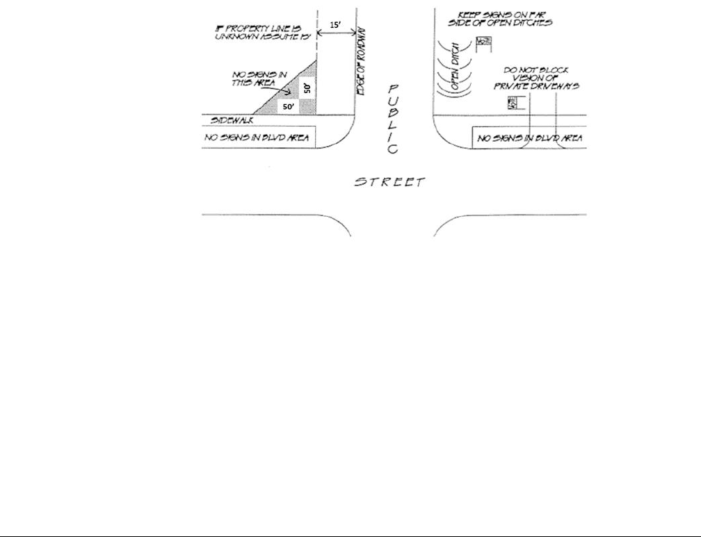
Oldham County Comprehensive Zoning Ordinance
Division 290 Sign Regulations
162
Political Sign
A temporary sign announcing or supporting political candidates or
issues in connection with any national, state, or local election. See
also KRS 117.235 regarding campaign-free zones.
Portable Sign
A sign that is not permanent, affixed to a building, structure, or the
ground.
Projecting Sign
A sign that is wholly or partly dependent upon a building for support
and that projects more than twelve inches from such building.
Projecting signs may include hanging signs, suspended signs,
awning signs, canopy signs, and marquee signs.
Property Line
A line of record bounding a lot that divides one lot from another lot
or from a public or private street or any other public space.
Right-of-Way
A strip of land determined on a site-specific basis that includes a
roadway, sidewalk or railroad to accommodate traffic and safety
requirements, utilities, environmental issues, and maintenance.
Roof Sign
A sign that is displayed above the eave, parapet or deck line of a roof
and under the peak of a building or roof. For the purpose of this sign
regulation, a sign on a mansard roof shall be considered a roof sign.
Examples of Roof Signs:
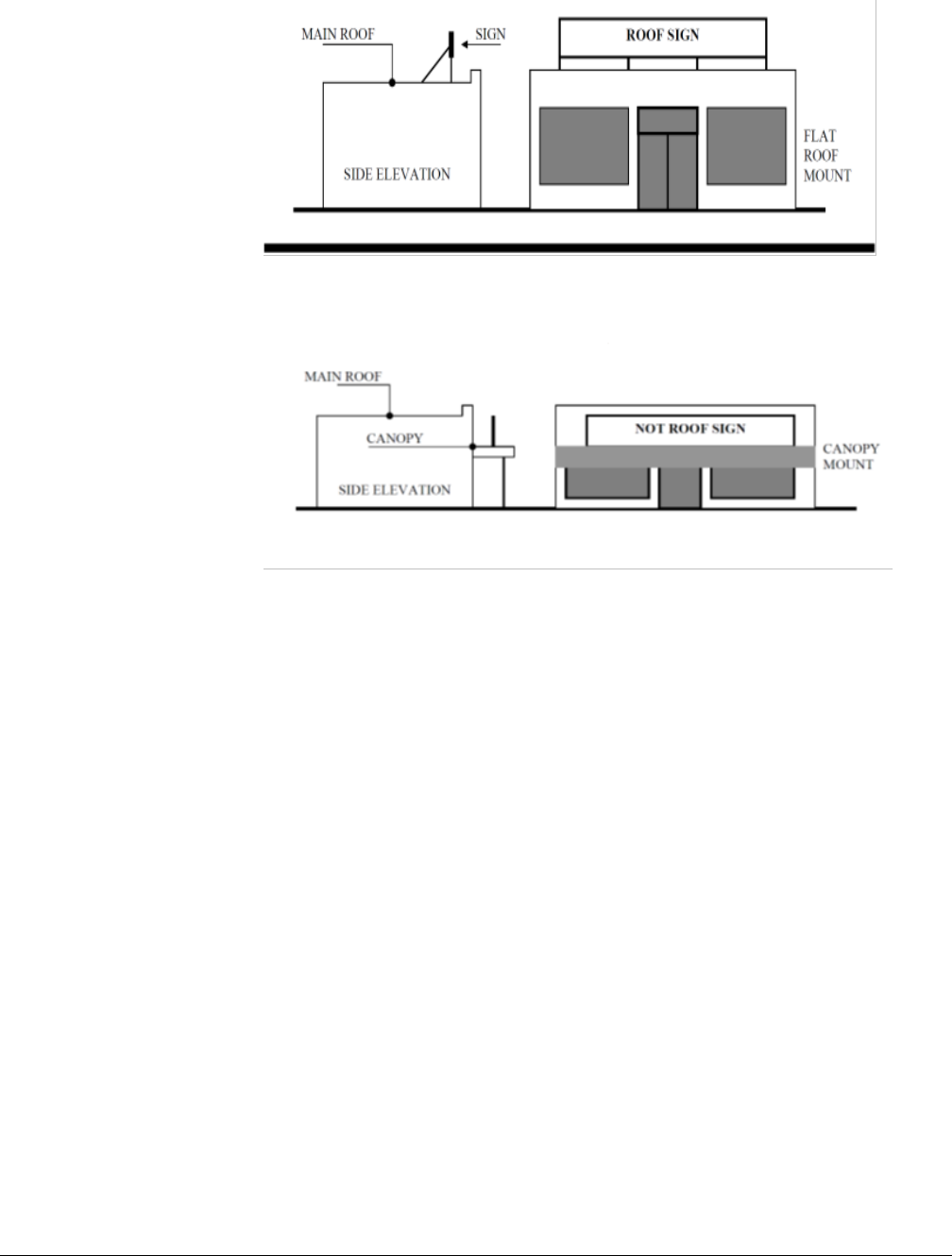
Oldham County Comprehensive Zoning Ordinance
Division 290 Sign Regulations
163
Examples of Wall Signs (Not Considered Roof Signs):
Sign
Any object, device, display, or structure, or part thereof, situated
outdoors or indoors, which is used to advertise, identify, display,
direct, or attract attention to an object, person, institution,
organization, business, product, service, event, or location by any
means, including words, letters, figures, design, symbols, fixtures,
colors, illumination, or projected images.
Sign Area
The entire face of a sign, including the advertising surface and any
framing, trim, or molding but not including the supporting structure.
Sign Face
The area or display surface used for the message.
Sign Height
The distance from grade to the highest point on the sign structure.
Any raised landscaped bed or foundation the sign may rest upon
shall be included in the total sign height.
Sign Permit
Document issued by the Planning & Zoning Office to the sign
applicant granting permission to construct or install a sign.
Snipe Sign
Temporary sign of six square feet or less made of vinyl, polyboard,
coroplas, corrugated plastic, plastic core, wood, or plywood,
including signs with wood or wire framing, posts, or stakes.
Temporary Sign
A sign or advertising display that is portable, and/or constructed of
cloth, canvas, fabric, plywood, or other light material.

Oldham County Comprehensive Zoning Ordinance
Division 290 Sign Regulations
164
Vehicle Sign
A sign on a vehicle not customarily and regularly used to transport
persons or properties.
Wall Sign
A sign fastened to or painted on the wall of a building or structure.
For the purpose of this sign regulation, a sign on a mansard roof
shall be considered a roof sign.
Window Sign
A sign applied, painted or affixed to or in the window of a building.
A window sign may be permanent or temporary.
Sec. 290-040 Procedure
A sign permit shall be obtained prior to the construction or erection of any new allowable sign and the
fee will be required in conjunction with said application. Sign permits are not required for the
replacement of sign cabinets, as long as the sign area, height and location are not being changed. A sign
permit shall be obtained prior to the re-use of an Abandoned Sign (see definition), and must comply with
the current sign regulations.
Sec. 290-045 Sign Permits
Oldham County Planning and Development Services issue permits for all signs outside of the city limits
of LaGrange and Pewee Valley. The City of LaGrange follows the regulations outlined in this division
and issues sign permits for sign requests within the city limits of LaGrange. The City of Pewee Valley
has adopted their own sign ordinance and issues sign permits for sign requests within the city limits of
Pewee Valley.
The following information shall be included along with the application and fee (refer to the current
fee schedule in the Planning & Zoning Office) at the time of submittal:
1. Name, address and telephone number of the applicant. Name, address and signature of the owner
of property on which the sign is to be located.
2. The location, size, height and type of each existing sign to remain on the property;
3. A site plan of the property on which the sign is to be erected showing property lines, existing
structures, right-of-way lines and proposed location of the sign.
4. A drawing of the proposed sign showing display area dimensions, height of sign, and information
to be conveyed on sign.
5. The estimated cash value of the sign.
6. If the sign is temporary the following applies:
a. The length of time anticipated for use of the sign;
b. A statement by the applicant in which he or she agrees to remove temporary signs within
the time limit herein established.
Sec. 290-050 Sign Requirements/Allowances Calculations
1. For the purposes of this ordinance:
a. The front setback is measured from the right-of-way or the front property line.
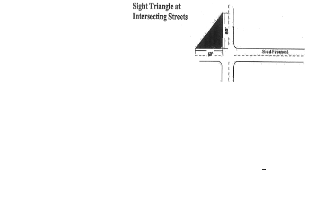
Oldham County Comprehensive Zoning Ordinance
Division 290 Sign Regulations
165
b. If a parcel has multiple frontages, then the parcel has multiple front setbacks.
c. The side yard setback is measured from the side property line.
2. The height of a sign shall be computed as the distance from the base of the sign at normal average
grade to the top of the highest attached component of the sign. Normal average grade shall be
construed to be the lower of: existing-grade prior to construction or installation, or the newly
established grade after construction or installation.
3. The area of a sign shall be computed by means of the smallest square, circle, rectangle,
triangle, or combination thereof that will encompass the extreme limits of the writing,
representation, emblem or other display, together with any material or color forming an integral
part of the background of the display or used to differentiate the sign from the backdrop or structure
against which it is placed. Supporting framework, bracing or structure shall not be included in
computation of sign area.
4. Unless otherwise stated, the total area of a sign having two or more sides or faces shall be
calculated according to the following:
a. Double-faced signs: the sign area is of one sign face only.
b. “V” shaped signs with two sides or faces: the sign area is the sum of the areas of the two
sign faces.
c. Signs with three or more sides or faces: the sign area is the sum of the areas of all sides or
faces.
5. Clear sight triangles shall be
maintained at all street intersections
for a minimum of 50 feet as measured
along the curb or pavement edge. No
free-standing signs shall be allowed in
the clear sight triangle.
Sec. 290-060 Exempt Sign Standards
The following types of signs are not required to obtain a sign permit and shall not be counted towards
the total number of signs and allowable sign area, but must meet the following limitations:
1. Wall signs of two square feet or less.
2. Free standing sign of six square feet or less and with a height of two feet or less. One per road
frontage is permitted with consent of the property owner.
3. On-Site Directional/Information Sign of six square feet or less– Must not be a public safety hazard.
4. Public signs, notices or traffic signs required by law, or any sign relating to an emergency.
5. Signs carried by a person – Must not be a public safety hazard.
6. Signs integrated into or on a coin-operated machine, vending machine, gasoline pump, or
telephone booth.
7. Signs within a ballpark, field or diamond shall be oriented toward the field or diamond and shall
not be higher that the fences.

Oldham County Comprehensive Zoning Ordinance
Division 290 Sign Regulations
166
8. Traffic signs-traffic control signs that comply with the “Manual of Uniform Traffic Control
Devices for Streets and Highways”.
9. Temporary window signs in commercial zoning districts – Total area of window signs shall not
exceed 30% of the window area of the façade of the building.
10. Flags, symbolic in nature, for non-commercial, non-promotional purposes:
a. The total area of all flags on a lot shall not exceed 60 square feet in area.
b. No flag shall be flown from a pole that exceeds 35 feet in height.
c. If a flag is mounted to a building, the vertical clearance from ground level when limp shall
not be less than 9 feet.
d. No flag shall be mounted above the roofline of a structure.
11. Electronic signs not exceeding 4 square feet provided that there is no more than one such sign per
business establishment (not applicable in LaGrange).
12. In the City of LaGrange signs stating that a business other than a home occupation is open,
provided that there is no more than one such sign per business establishment inside the building,
and that such sign does not exceed four (4) square feet in area. Neon signs are allowable in this
case.
Sec. 290-070 Signs Prohibited
The following signs are prohibited:
1. Any sign or part of a sign that incorporates in any manner any continuous scrolling, flashing,
blinking, oscillating or moving lights, or that changes physical position or light intensity by any
movement or rotation or that gives the appearance of such movement or rotation.
2. String lights or any unshielded light that is visible by the public from a public street or produces
glare onto a residential structure, and is used in connection with commercial premises for
commercial purposes, including attention-getting, other than seasonal decorations.
3. Any sign which has any visible moving part, visible revolving parts or visible mechanical
movement achieved by electronic or mechanical means or action of normal wind currents.
4. Any sign which obstruct or detract from the visibility of any traffic sign or traffic control devise
on public streets and roads, by reason of the size, location, coloring, or illumination.
5. Any sign or sign structures which (a) is structurally unsafe, (b) constitutes a hazard to safety or
health by reason of inadequate maintenance, dilapidated or abandonment, (c) is not kept in good
repair, or (d) is capable of causing electrical shocks to persons likely to come into contact with it.
6. Signs which make use of words such as “STOP”, “LOOK”, “DANGER”, “YIELD”, or other
similar words, phrases, symbols or characters in such a manner to imply the need or requirement
of stopping or the existence of danger.
7. Permanent use of portable signs, such as snipe signs, folding signs, “A” frame signs, or any other
similar temporary sign.
8. Free standing signs that extend or are built over public property and/or signs in the right-of-way
9. Wall signs painted on a building, except as permitted under conditional use application by the
appropriate Board of Adjustments and Appeals, after public hearing. Area requirements are same
as for permitted wall signs in zoning district in which property is located.

Oldham County Comprehensive Zoning Ordinance
Division 290 Sign Regulations
167
10. Any sign erected or maintained upon a utility pole, traffic control device or tree; or painted or
drawn upon rocks or other natural features.
11. No marquee constructed over sidewalks in those districts where permitted shall extend closer than
two feet to the curb line of any adjoining street.
12. Above-roof signs.
13. Signs on vehicles or trailers which are parked or located for the primary purpose of displaying said
sign.
14. Backlit awning signs.
Sec. 290-080 Sign Lighting
1. Signs may be internally illuminated, backlit, or illuminated by downlighting or by ground-mounted
light fixtures that illuminate the sign face and base only.
2. Illumination of the sign face by ground-mounted light fixtures shall not exceed 50 foot-candles as
measured on the sign face.
3. Illumination for temporary signs is prohibited.
4. Signs shall not have exposed bare-bulb or flashing illumination.
5. In the city of LaGrange internally illuminated signs other than changeable copy signs shall have
opaque backgrounds with translucent letters, symbols and logos unless the background is integral
to the design of a corporate image or registered trademark.
6. In the city of LaGrange the use of neon window signs is prohibited, and illuminated banding on
buildings shall be limited to one band.
Sec. 290-090 Electronic Signs
Electronic Signs Prohibited:
1. Electronic Signs shall be prohibited in the following zoning districts: IPD District, AG-1, CO-1,
T, R-1, R-1A, R-2, R-2A, R-3 and R-4A Zoning Districts.
2. Electronic Signs displayed as wall signs, projecting signs, or roof signs in any zoning district are
prohibited.
3. Electronic Signs with continuous scrolling, flashing, blinking or oscillating messages are
prohibited.
4. Electronic Signs with displaces other than alpha-numeric messaging are prohibited.
Electronic Signs Permitted:
R-4 (Professional Office Use Only), C-1, C-2, C-3, C-4, I-1, I-2 Zoning Districts: Electronic Signs shall
be permitted in these zoning districts subject to the following (permitted only in C-3, C-4, I-1 and I-2
Zoning Districts in the city of LaGrange):
1. Electronic Signs shall only be displayed on allowable freestanding or monument signs and shall
not exceed allowable height requirements (excluding electronic transmitter devices) for the zoning
districts in which the sign is located.

Oldham County Comprehensive Zoning Ordinance
Division 290 Sign Regulations
168
2. Square footage of the Electronic Sign shall not exceed 50% of the total allowable square footage
for freestanding or monument signs for the zoning district in which the sign is located or shall not
exceed 24 square feet, whichever is lesser.
3. Alpha-numeric message shall change in increments not less than 60 second intervals and the
change must be complete in one second.
4. No more than one Electronic Sign shall be attached to a permitted, conforming freestanding or
monument sign per parcel or business.
5. Electronic Signs shall not be added to any legal non-conforming freestanding or monument signs.
Sec. 290-100 Permanent Signage
1. AG-1, CO-1, T, R-1, R-1A, R-2, R-2A, R-3, R-4 and R-4A Zoning Districts
A. Two identification signs are allowed at a major entrance of a subdivision, apartment or
condominium complex, not to exceed 48 square feet in sign area for each sign.
i. Signs shall have a maximum height limit of 12 feet (6 feet in LaGrange).
ii. Signs shall have a setback of 15 feet from any public right-of-way.
B. All other signs in the above zoning districts must meet a minimum of 15 feet front setback and
shall not be larger than 24 square feet in area and shall not be taller than 8 feet in height (6 feet
in LaGrange). Only one sign per lot is allowed.
C. Roof signs are not allowed in the above zoning districts.
D. In the city of LaGrange all free-standing signs in the above zoning districts shall be either
monument signs or mounted on two posts.
2. Property zoned R-4 with the intended use of Professional Offices may be allowed signage under
the following constraints:
A. A. Professional Offices may be allowed two identification signs, only one of which may be
separated from the building.
B. Free-standing signs-Professional offices:
i. Minimum front setback of 5 feet.
ii. Maximum area of 24 square feet.
iii. Maximum height of 8 feet (6 feet in LaGrange). (In the city of LaGrange all free-
standing signs in the R-4 zoning district shall be either monument signs or mounted on
2 posts.)
C. Wall Signs-Professional Offices:
i. The maximum area shall be one square foot for each lineal foot of the building frontage
owned/leased by the applicant, or 50 square feet, whichever is less.
ii. Not higher than roof or parapet line.
iii. May not extend over 1/3 of public sidewalk.
D. Projecting Signs-Professional Offices:
i. The maximum area shall be one square foot for each lineal foot of building frontage
owned/leased by the applicant, or 15 square feet, whichever is less.
ii. Not higher than roof or parapet line.
iii. May not extend over 1/3 of public sidewalk.

Oldham County Comprehensive Zoning Ordinance
Division 290 Sign Regulations
169
E. Roof Signs are not allowed in the R-4 zoning district.
3. O-1 and O-2 Office Districts, C-N Commercial Neighborhood District may allow no more than
two identification signs per parcel, one of which may be separated from the principal building.
A. Free-Standing Signs
i. No signs shall be any closer than 5 feet from any property line.
ii. No lot frontage shall have a free-standing sign unless the frontage is at least 50 feet
wide and the building situated on that lot is set back at least 15 feet from the street
right-of-way line.
iii.
City of LaGrange: only monument signs are allowed
Front Sign Setback
Max Sign
Height
Max Sign
Area
Maximum
Monument Area
5’ to less than 10’
6’
20 Sq. Ft.
4 Sq. Ft
10’ to less than 15’
8’
24 Sq. Ft.
8 Sq. Ft.
15’ to less than 20’
10’
28 Sq. Ft.
12 Sq. Ft.
20 ‘ or more
12’
40 Sq. Ft.
20 Sq. Ft.
iv. For a multi-tenant building or development, the maximum sign area may be increase
by up to 50% if all occupants share the same sign and no other free-standing signs are
displayed on the premises.
v. In the city of LaGrange all free-standing signs in the above zoning districts shall be a
monument sign.
B. Wall Signs
i. The maximum area shall be one square foot for each lineal foot of building frontage
owned/leased by the applicant or 50 square feet, whichever is less.
ii. Not higher than roof or parapet line.
iii. May not extend more than 12 inches from wall.
C. Projecting Signs
i. The maximum area shall be one square foot for each lineal foot of building frontage
owned/leased by the applicant or 15 square feet, whichever is less.
ii. Shall not be higher than roof or parapet line.
iii. May not extend over 1/3 of public sidewalks.
D. Roof Signs: Roof signs are not allowed in the O-1, O-2 and C-N zoning districts.
Front Sign Setback
Max Sign Height
Max Sign Area
5’ to less than 10’
10’
12 Sq. Ft.
10’ to less than 15’
15’
16 Sq. Ft.
15’ to less than 20’
20’
25 Sq. Ft.
20’ or more
25’
25 Sq. Ft.

Oldham County Comprehensive Zoning Ordinance
Division 290 Sign Regulations
170
4. C-1 Local Business District may allow no more than two identification signs per parcel, one of
which may be separated from the principal building. Additional signs may be allowed if:
i. A parcel has a total street frontage exceeding 600 feet in which case a second free-
standing sign shall be allowed. Each free-standing sign shall be allowed to have a sign
area up to the maximum allowable sign area for the zoning district. However, the
distance between the two free-standing signs shall be no less than 300 feet.
ii. A parcel has frontage on two or more streets in which case one wall sign for each
frontage shall be allowed.
A. Free-Standing Signs:
i. No sign shall be any closer than five feet from any property line.
ii. No lot frontage shall have a free-standing sign unless the frontage is at least 50 feet
wide and the building situated on that lot is set back at least 15 feet (20 feet in
LaGrange) from the street right-of-way line.
iii.
Front Sign Setback
Max Sign Height
Max Sign Area
5’ to less than 10’
15’
12 Sq. Ft.
10’ to less than 15’
20’
16 Sq. Ft.
15’ to less than 20’
25’
25 Sq. Ft.
20’ or more
30’
25 Sq. Ft.
City of LaGrange: only monument signs are allowed
Front Sign Setback
Max Sign
Height
Max Sign
Area
Maximum
Monument Area
5’ to less than 10’
6’
20 Sq. Ft.
4 Sq. Ft
10’ to less than 15’
8’
24 Sq. Ft.
8 Sq. Ft.
15’ to less than 20’
10’
28 Sq. Ft.
12 Sq. Ft.
20 ‘ or more
12’
40 Sq. Ft.
20 Sq. Ft.
iv. For a multi-tenant building or development, the maximum sign area may be increased
by up to 50% if all occupants share the same sign and no other free-standing signs are
displayed on the premises.
v. In the city of LaGrange all free-standing signs in the above zoning district shall be
monument signs.
B. Wall Signs:
i. The maximum area shall be one square foot for each lineal foot if building frontage
owned/leased by the applicant or 50 square feet, whichever is less.
ii. Shall not be higher than roof or parapet line.
iii. May not extend more than 12 inches from wall.
C. Projecting Signs:
i. The maximum area shall be one square foot for each lineal foot of building frontage
owned/leased by the applicant or 15 square feet, whichever is less.
ii. Shall not be higher than roof or parapet line.
iii. May not extend over 1/3 of public sidewalks.

Oldham County Comprehensive Zoning Ordinance
Division 290 Sign Regulations
171
D. Roof Signs:
i. The maximum area shall be one square foot for each lineal foot of building frontage
owned/leased by the applicant or 24 square feet, whichever is less.
ii. The maximum height measured from the bottom of the sign to the top of the sign shall
be 36”.
iii. Top of sign shall not extend higher than the peak of the roof.
iv. A roof sign shall not extend higher than the maximum building height requirement.
v. Roof signs are not allowed in the city of LaGrange.
5. C-2 Community Business District may allow no more than two identification signs per parcel,
one of which may be separated from the principal building. Additional signs may be allowed if:
i. A parcel has a total street frontage exceeding 600 feet in which case a second free-
standing sign shall be allowed. Each free-standing sign shall be allowed to have a sign
area up to the maximum allowable sign area for the zoning district. However, the
distance between the two free-standing signs shall be no less than 300 feet.
ii. A parcel has frontage on two or more streets in which case one wall sign for each
frontage shall be allowed.
A. Free-Standing Signs:
i. No sign shall be any closer than 5 feet from the property line.
ii. No lot frontage shall have a free-standing sign unless the frontage is at least 50 feet
wide and the building situated on that lot is set back at least 15 feet from the street
right-of-way line.
Front Setback
Max Sign Height
Max Sign Area
5’ to less than 10’
15’
24 Sq. Ft.
10’ to less than 15’
20’
32 Sq. Ft.
15’ to less than 20’
25’
40 Sq. Ft.
20’ or more
30’
50 Sq. Ft.
City of LaGrange: only monument signs are allowed
Front Sign Setback
Max Sign
Height
Max Sign
Area
Maximum
Monument Area
5’ to less than 10’
6’
20 Sq. Ft.
4 Sq. Ft
10’ to less than 15’
8’
24 Sq. Ft.
8 Sq. Ft.
15’ to less than 20’
10’
28 Sq. Ft.
12 Sq. Ft.
20 ‘ or more
12’
40 Sq. Ft.
20 Sq. Ft.
iii. For a multi-tenant building or development. The maximum sign area may be increased
by up to 50% if all occupants share the same sign and no other free-standing signs are
displayed on the premises.
iv. In the city of LaGrange, all free-standing signs in the above zoning district shall be
monument signs.

Oldham County Comprehensive Zoning Ordinance
Division 290 Sign Regulations
172
B. Wall Signs:
i. One square foot for each lineal foot of building frontage owned/leased by the applicant
is the maximum area not to exceed 150 square feet.
ii. Shall not be higher than roof or parapet line.
iii. May no extend more than 12 inches from the wall.
C. Projecting Signs:
i. The maximum area shall be one square foot for each lineal foot of building frontage
owned/leased by the applicant or 50 square feet, whichever is less.
ii. Shall not be higher than roof or parapet line.
iii. May not extend over 1/3 of public sidewalk.
D. Roof Signs:
i. The maximum area shall be one square foot for each lineal foot of building frontage
owned/leased by the applicant or 24 square feet, whichever is less.
ii. The maximum height measured from the bottom of the sign to the top of the sign shall
be 36”.
iii. Top of sign may not extend higher than the peak of the roof.
iv. A roof sign may not extend higher than the maximum building height requirement.
v. Roof signs are not allowed in the city of LaGrange.
6. C-3 General Business District may allow no more than two identification signs per parcel, one of
which may be separated from the principal building. Additional signs may be allowed if:
i. A parcel has a total street frontage exceeding 600 feet in which case a second free-
standing sign shall be allowed. Each free-standing sign shall be allowed to have a sign
area up to the maximum allowable sign area for the zoning district. However, the
distance between the two free-standing signs shall be no less than 300 feet.
ii. A parcel has frontage on two or more streets in which case one wall sign for each
frontage shall be allowed.
A. Free-Standing Signs:
i. No sign shall be any closer than 5 feet from any property line.
ii. No lot frontage shall have a free-standing sign unless the frontage is at least 50 feet
wide and the building situated on that lot is set back at least 15 feet (30 feet in
LaGrange) from the street right-of-way line.
Front Setback
Max Sign Height
Max Sign Area
5’ to less than 10’
15’
32 Sq. Ft.
10’ to less than 15’
20’
40 Sq. Ft.
15’ to less than 20’
25’
50 Sq. Ft.
20’ to less than 25’
30’
60 Sq. Ft.
25’ or more
35’
75 Sq. Ft.

Oldham County Comprehensive Zoning Ordinance
Division 290 Sign Regulations
173
City of LaGrange: only monument signs are allowed
Front Sign Setback
Max Sign
Height
Max Sign
Area
Maximum
Monument Area
5’ to less than 10’
8’
32 Sq. Ft.
8 Sq. Ft
10’ to less than 15’
10’
38 Sq. Ft.
12 Sq. Ft.
15’ to less than 20’
15’
54 Sq. Ft.
21 Sq. Ft.
20’ to less than 25’
18’
60 Sq. Ft.
30 Sq. Ft.
25’ or more
20’
75 Sq. Ft.
45 Sq. Ft.
iii. For multi-tenant building or development, the maximum sign area may be increased by
up to 50% if all occupants share the same sign and no other free-standing signs are on
the premises.
iv. In the city of LaGrange all free-standing signs in the above zoning district shall be
monument signs.
B. Wall Signs:
i. One square foot for each lineal foot of building frontage owned/leased by the applicant
is the maximum area.
ii. Shall not be higher than roof or parapet line.
iii. May not extend more than 12 inches from wall.
C. Projecting Signs:
i. The maximum area shall be one square foot for each linear foot of building frontage
owned/leased by the applicant or 75 square feet, whichever is less.
ii. Shall not be higher than roof or parapet line.
iii. May not extend over 1/3 of public sidewalk.
D. Roof Signs:
i. The maximum area shall be one square foot for each lineal foot of building frontage
owned/leased by the applicant or 24 square feet whichever is less.
ii. The maximum height measured from the bottom of the sign to the top of the sign shall
be 36”.
iii. Top of the sign may not extend higher than the peak of the roof.
iv. A roof sign may not extend higher than the maximum building height requirement.
v. Roof signs are not allowed in the city of LaGrange.
7. C-4 Highway Service District may allow no more than two identification signs per parcel, one of
which may be separated from the principal building. Additional signs may be allowed if:
i. A parcel has a total street frontage exceeding 600 feet in which case a second free-
standing sign shall be allowed. Each free-standing sign shall be allowed to have a sign
area up to the maximum allowable sign area for the zoning district. However, the
distance between the two free-standing signs shall be no less than 300 feet.
ii. A parcel has frontage on two or more streets in which case one wall sign for each
frontage shall be allowed.
Oldham County Comprehensive Zoning Ordinance
Division 290 Sign Regulations
174
A. Free-Standing Signs
i. No sign shall be any closer than 5 feet from any property line.
ii. No lot frontage shall have a free-standing sign unless the frontage is at least 50 feet
wide and the building situated on that lot is set back at least 15 feet from the street
right-of-way line.
iii.
Front Sign Setback
Max Sign Height
Max Sign Area
5’ to less than 10’
15’
32 Sq. Ft.
10’ to less than 15’
20’
40 Sq. Ft.
15’ to less than 20’
25’
50 Sq. Ft.
20’ to less than 25’
30’
60 Sq. Ft.
25’ to less than 30’
35’
75 Sq. Ft.
30’ to less than 40’
40’
90 Sq. Ft.
40’ and more
45’
100 Sq. Ft.
City of LaGrange
Front Sign Setback
Max
Sign
Height
Max Sign
Area
Maximum
Monument Area
5’ to less than 10’-Only monument signs allowed
8’
34 Sq. Ft.
6 Sq. Ft.
10’ to less than 15’- Only monument signs allowed
10’
40 Sq. Ft.
10 Sq. Ft.
15’ to less than 20’- Only monument signs allowed
15’
54 Sq. Ft.
21 Sq. Ft.
20’ to less than 25’- Only monument signs allowed
18’
56 Sq. Ft.
24 Sq. Ft.
25’ to less than 30’-Only 2-pole signs allowed
26’
96 Sq. Ft.
30’ to less than 40’-Only 2-pole signs allowed
32’
100 Sq. Ft.
40’ or more-Only 2-pole signs allowed signs allowed
32’
110 Sq. Ft.
iii. For a multi-tenant building or development, the maximum sign are may be increased
by up to 50% if all occupants share the same free-standing sign and no other free-
standing signs are displayed on the premises.
iv. For aesthetic purposes within the city of LaGrange all free-standing pole signs in the
above zoning district shall use round or rectangular poles within a minimum diameter
or width of 20 inches.
B. Wall Signs:
i. One square foot for each lineal foot of building frontage owned/leased by the applicant
is the maximum area.
ii. Shall not be higher than the roof or parapet line.
iii. May not extend more than 12 inches from wall.

Oldham County Comprehensive Zoning Ordinance
Division 290 Sign Regulations
175
C. Projecting Signs:
i. The maximum area shall be one square foot for each lineal foot of the building frontage
owned/leased by the applicant or 100 square feet, whichever is less.
ii. Shall not be higher than roof or parapet line.
iii. May not extend over 1/3 of public sidewalk.
D. Roof Signs:
i. The maximum area shall be one square foot for each lineal foot of building frontage
owned/leased by the applicant or 24 square feet, whichever is less.
ii. The maximum height measured from the bottom of the sign to the top of the sign shall
be 36”.
iii. Top of sign may not extend higher than the peak of the roof.
iv. A roof sign may not extend higher than the maximum building height requirement.
v. Roof signs are not allowed in the city of LaGrange.
8. I-1 Light Industrial District, I-2 Heavy Industrial District may allow no more than two
identification signs per parcel, one of which may be separated from the principal building.
Additional signs may be allowed if:
i. A parcel has a total street frontage exceeding 600 feet in which case a second free-
standing sign shall be allowed. Each free-standing sign shall be allowed to have a sign
area up to the maximum allowable sign area for the zoning district. However, the
distance between the two free-standing signs shall be no less than 300 feet.
ii. A parcel has frontage on two or more streets in which case one wall sign for each
frontage shall be allowed.
A. Free-Standing Signs:
i. No sign shall be any closer than 5 feet from any property line.
ii. No lot frontage shall have a free-standing sign unless the frontage is at least 50 feet
wide and the building situated on that lot is set back at least 15 feet from the street
right-of-way line.
iii.
Front Sign Setback
Max Sign Height
Max Sign Area
5’ to less than 10’
15’
32 Sq. Ft.
10’ to less than 15’
20’
40 Sq. Ft.
15’ to less than 20’
25’
50 Sq. Ft.
20’ to less than 25’
30’
60 Sq. Ft.
25’ or more
35’
75 Sq. Ft.
City of LaGrange: only monument signs are allowed
Front Sign Setback
Max Sign
Height
Max Sign
Area
Maximum
Monument Area
5’ to less than 10’
8’
26 Sq. Ft.
6 Sq. Ft
10’ to less than 15’
8’
30 Sq. Ft.
10 Sq. Ft.
15’ to less than 20’
8’
46 Sq. Ft.
36 Sq. Ft.
20’ or more
8’
54 Sq. Ft.
26 Sq. Ft.

Oldham County Comprehensive Zoning Ordinance
Division 290 Sign Regulations
176
iv. For a multi-tenant building or development, the maximum sign area may be increased
by up to 50% if all occupants share the same sign and no other free-standing signs are
displayed on the premises.
v. In the city of LaGrange all free-standing signs in the above zoning district shall be
monument signs.
B. Wall Signs:
i. One square foot for each lineal foot of building frontage owned/leased by the applicant
is the maximum area.
ii. Shall not be higher than the roof or parapet line.
iii. May not extend more than 12 inches from wall.
C. Projecting Signs:
i. The maximum area shall be one square foot for each linear foot of building frontage
owned/leased by the applicant or 75 square feet, whichever is less.
ii. Shall not be higher than roof or parapet line.
iii. May not extend over 1/3 of public sidewalk.
D. Roof Signs:
i. The maximum area shall be one square foot for each lineal foot of building frontage
owned/leased by the applicant or 24 square feet, whichever is less.
ii. The maximum height measured from the bottom of the sign to the top of the sign shall
be 36”.
iii. Top of the sign may extend higher than the peak of the roof.
iv. A roof sign may not extend higher than the maximum building height requirement.
v. Roof signs are not allowed in the city of LaGrange.
9. IPD Industrial Park District may allow no more than two identification signs per parcel, one of
which may be separated from the principal building. Additional signs may be allowed if:
i. A parcel has a total street frontage exceeding 600 feet in which case a second free-
standing sign shall be allowed. Each free-standing sign shall be allowed to have a sign
area up to the maximum allowable sign area for the zoning district. However, the
distance between the two free-standing signs shall be no less than 300 feet.
ii. A parcel has frontage on two or more streets in which case one wall sign for each
frontage shall be allowed.
A. Free-Standing Signs:
i. A single free-standing sign may be installed per lot. Free-standing signs shall be
designed and installed as a monument style sign.
ii. Free-Standing Sign Minimum Setbacks:
iii. Front Yard – 10 feet
iv. Side Yard – 15 feet
v. A free-standing sign cannot obstruct the view of vehicular traffic at street intersections
or driveway entrances. Free-standing signs shall not encroach into any determined clear
site triangle.

Oldham County Comprehensive Zoning Ordinance
Division 290 Sign Regulations
177
vi. Free Standing Sign Size:
vii. Maximum Sign Height: 6 feet
viii. Maximum Sign Area 60 square feet per side (120 square feet total)
B. Wall-Mounted Signs:
A wall-mounted sign may be installed per every building façade facing a public right-of-way,
i. Wall Sign Size:
ii. Maximum Sign Area – one square foot of sign area for each lineal foot of building
facing the publics’ right-of-way.
iii. Wall signs shall not extend above the roof line of the building façade in which they are
located.
C. Prohibited Signs:
The following types or styles of signs shall be prohibited:
i. Electronic signs with changing advertisements or display faces.
ii. Flashing signs.
iii. Mechanical signs with movement.
iv. Portable signs.
v. Roof signs.
Sec. 290-120 Temporary Signage
A temporary sign permit shall be obtained prior to the placement of any combination of signs, banners,
posters, pennants, portable signs, flags, inflatable devices, or other similar devices. The Planning &
Zoning Office reserves the right to revoke a temporary sign permit at any time. The following rules
apply to temporary sign permits.
Sign Requirements/Allowances
1. Temporary wall signs of two square feet or less and temporary free-standing signs of six square
feet or less are allowed and do not require a sign permit. One per road frontage is permitted.
2. Permits are valid for 30 days and no more than one such permit may be issued per property per
calendar quarter (Jan-March, Apr-June, July-Sept, Oct-Dec).
3. The area of the temporary sign attached to a building or structure may be equal but not greater
than one square foot for every lineal foot of building frontage owned/leased by the applicant, not
to exceed 32 square feet.
4. Free-standing signs must comply with the front setback, height and area requirements for the
zoning district in which they are located, not to exceed 32 square feet.
5. More than one temporary sign may be permitted simultaneously as long as the total area of all
temporary signs does not exceed the maximum sign area.
6. Various types of portable signs may be used on a temporary basis by permit (not allowed in the
city of LaGrange).
7. Temporary signs may not have internal or external lighting.

Oldham County Comprehensive Zoning Ordinance
Division 290 Sign Regulations
178
8. The Planning & Zoning Office may revoke this permit if the appearance of the banner becomes a
safety hazard or is in disrepair.
Sec. 290-130 Areas of Special Character
The Commission may approve a special sign regulation for an Area of Special Character following
notice and hearing. The special sign regulations in Areas of Special Character shall be consistent with
the purposes of this ordinance and the character of the Area of Special Character.
Special sign regulations for Areas of Special Character shall supersede and may be either more or less
restrictive than the sign regulations contained in this ordinance.
1. Historic Districts: A historic district may establish a special sign regulation.
2. Municipalities: Each municipality may establish a special sign regulation.
3. Planned Unit Development Districts: A Planned Unit Development may establish a special sign
regulation.
Sec. 290-140 Programs for Signs
1. Purpose: A Program for Signs is a creative incentive for a unified visual statement that integrates
the design of signs with the design of the building on which they will be displayed and with the
surrounding area.
2. When allowed: The owners of one or more adjacent premises, or one or more occupants of a
shopping center or multi-use building, may submit a Program for Signs to the Commission that
need not comply with some or all of the requirements of this ordinance. The Program for Signs
shall contain a visual representation of the lettering, illumination, color, size, height, placement,
and location of the signs proposed for display.
3. Standards for Approval: The Commission may approve a Program for Sign following notice and
the Commission hearing if the signs visually represented in the program are:
4. Consistent with the purposes of this ordinance; and
5. Compatible with the theme, visual quality, and overall character of the surrounding area or an
Area of Special Character, if the signs included in the Program for Signs are located in such an
area; and
6. Appropriately related in size, shape, materials, color, illumination, and character to the function
and architectural character of the building or premises on which they will be displayed, and are
compatible with existing adjacent activities.
7. Display of Signs: A premises or occupancy for which a Program for Signs has been approved by
the commission may only display signs that comply with the approved program, which shall
supersede and replace the regulations for signs in this ordinance.
Sec. 290-150 Signs along Scenic Corridors
Scenic Corridors Designated: The following road segments in Oldham County are designated as Scenic
Corridors and have associated signage requirements:

Oldham County Comprehensive Zoning Ordinance
Division 290 Sign Regulations
179
1. Interstate 71 Corridor
For the purpose of this sign regulation, the Interstate 71 Corridor shall be defined as shown below.
(A map showing the boundary of the Interstate 71 Corridor is available at the Planning and Zoning
Office).
Signs located along the Interstate 71 corridor, shall meet the following design standards in addition
to the standards in the zoning district in which the sign is located:
a. No billboards shall be located within fifteen hundred (1,500) feet of the center of the
nearest travel lane of Interstate 71. A billboard, also known as an off-premise sign, is
defined as a sign that directs attention to a business, commodity, service, or
entertainment conducted, sold or offered at a location other than the premise on which
the sign is located. Billboards are not allowed in the city of LaGrange.
b. No roof signs shall be located within six hundred sixty (660) feet of the center of the
nearest travel lane of Interstate 71. Roof signs are not allowed in the city of LaGrange.
c. No free-standing signs, banners or wall signs shall be located within three hundred
(300) feet of the center of the nearest travel lane of Interstate 71.
d. No free-standing signs shall exceed eighty (80) square feet in area on one side and one
hundred sixty (160) square feet in area on all sides when located between three hundred
(300) and six hundred sixty (660) feet of the center of the nearest travel lane of
Interstate 71.
e. No signs located within fifteen hundred (1,500) feet of the center of the nearest travel
lane of Interstate 71 may be constructed or installed prior to being reviewed and
approved by the Kentucky Transportation Cabinet.
Sec. 290-160 Nonconforming Signs
Any sign legally in existence on the effective date of this sign regulation may continue in existence as a
matter of right with the following limitations. A change in copy is not an alternation for the purposes of
this subsection.
Non-conforming Sign Not to Expand. Non-conforming signs may not expand.
Non-conforming Sign Not to Rebuild. Any non-conforming sign which has been damaged to the extent
of 50 percent of its current fair cash value, as estimated immediately prior to damage, shall not be
repaired or reconstructed, except in conformity with this ordinance.
Abandoned Sign, Discontinued or Obsolete Non-Conforming Sign Not to Re-establish after One Year.
No non-conforming sign shall be re-established after having been discontinued or obsolete for twelve
(12) months. Vacating of premises or building, non-operative status, or not advertising or identifying a
bona fide business conducted on the property or product sold shall be evidence of a discontinued or
obsolete sign.

Oldham County Comprehensive Zoning Ordinance
Division 290 Sign Regulations
180
Ordinary Repair and Maintenance. Work may be done on ordinary repair and maintenance, or on repair
or replacement of sign fixtures or framing, sign writing, or sign face. Nothing in this ordinance shall be
deemed to prevent the strengthening ore restoring to be a safe condition of a sign or other structure in
accordance with the order of an appropriate public agency, and who declares such sign or other structure
to be unsafe and orders its restoration to be a safe condition.
Sec. 290-170 Variances
The Commission or the appropriate Board of Adjustments may grant variances from this sign regulation
if they find the variance requested by special or unique hardship.
A variance may be granted:
1. To permit a setback for a sign that is up to 25 percent less than the required setback; or
2. To permit the height of a sign to be increased by up to 25 percent more than the maximum height
(variances for height are not allowed in the city of LaGrange).
Sec. 290-180 Severability Clause
The invalidation of any section, subsection, clause, or phrase of this ordinance by any court of
competent jurisdiction shall not affect the validity of the remaining portions of this ordinance.

Oldham County Comprehensive Zoning Ordinance
Division 300 Landscaping Regulations
181
DIVISION 300 LANDSCAPING REGULATIONS
Sec. 300-010 Landscaping Regulations: Purpose
The purpose and intent of this Division is to preserve and promote the health, safety, and general welfare
of the public; to facilitate the creation of an attractive and harmonious community; to protect, preserve,
and promote the aesthetic appeal, character, and value of surrounding neighborhoods; to conserve
properties and their values; to preserve the character of an area by preventing the harmful effects of
potentially dissimilar uses; to encourage the appropriate use of land; and to conserve the natural
resources.
More specifically, this Division is intended to minimize the impact of dissimilar uses on adjoining or
nearby uses by requiring a screen or buffer between the uses in order to lessen the impact of noise, dust
and other debris, motor vehicle headlight glare or other artificial light intrusion, and other objectionable
activities or impacts conducted on or created by an adjoining or nearby use
Additionally, this Division is intended to require the landscaping of parking lots in order to reduce the
harmful effects of wind and air turbulence, heat and noise, and the glare of motor vehicle lights; to
preserve underground water resources and to permit the return of precipitation to the ground water
strata; to act as a natural drainage system and ameliorate storm water drainage problems; to reduce the
level of carbon dioxide and return oxygen to the atmosphere; to prevent soil erosion; to provide shade;
and to enhance the appearance of parking lots. Additionally, this Division is intended to require the
preservation and planting of trees on sites being developed to provide an appropriate percentage of tree
cover within ten (10) years.
Sec. 300-020 Relationship to the Comprehensive Plan
The landscape design regulations in this Division are intended to implement the goals, objectives, and
policies outlined in the Oldham County Comprehensive Plan.
The 2017 update of the Landscape Regulations is in response to Objective E-2-6 of the 2014
Comprehensive Plan, which calls for the improvement of these standards to guide the preservation of on-
site woodlands, provide appropriate buffers from adjacent uses, increase the urban and suburban tree
canopy, provide a vegetative buffer to riparian corridors, mitigate the effect of flooding and stormwater
run-off, and improve the visual appearance of structures, stormwater and parking facilities.
Sec. 300-030 Applicability
1. No site development, building, structure of Vehicular Use Area shall be created unless landscaping
is provided as required by the provisions of this Division. No building permit may be issued for
any lot or use subject to the requirements of this Division unless all requirements have been met
and approved by Planning Staff; or until financial instruments, as may be required by the
Administrator, to ensure timely compliance with this Division, have been put in place. Prior to
occupancy of the site, the required landscaping shall be installed in conformance with the approved

Oldham County Comprehensive Zoning Ordinance
Division 300 Landscaping Regulations
182
Plan, unless a full cash bond or an irrevocable letter of credit from a banking institution with offices
in Kentucky has been posted.
2. Failure to implement the landscape plan, or maintain the lot or use in conformance with this
Division and the approved plan, is cause for fines and penalties as established in Sec. 300-120 this
ordinance. In addition, all landscape is subject to periodic inspection.
3. No additional items or replacement of removed items is allowed in the right-of-way without an
Encroachment Permit.
4. Any building, structure, or Vehicular Use Area (VUA) that in its entirety is removed and
reconstructed, or relocated to a new on-site location, shall be required to meet the standards of this
Division.
5. Existing development is subject to this Division as defined below:
a. Any construction resulting in an increase/expansion in the area of an existing
building/structure’s square footage by twenty (20) percent or more.
b. Any construction resulting in an increase/expansion of an existing vehicular use area (VUA)
square footage by twenty (20) percent or more.
c. On small sites of one-half acre or less (1/4 acre or less within the city of LaGrange), where the
area of expansion of existing buildings, structures and/or VUAs is less than 50 percent, no
landscaping shall be required.
d. Change in the use of property from a use not required to provide landscaping and buffering to
a use that is regulated by this Division shall necessitate the provision of landscaping and
buffering as required by this Division.
i. If the existing landscaping meets or exceeds the required landscaping, there will be no
additional requirement.
6. Single family residential lots are exempt. See Section 300-050 B. Landscaping in Residential
Properties for requirements for residential developments.
7. Phased development shall construct landscaping at each phase.
8. Institutional uses shall comply with all sections of this Division except for Section 300-050, C.
Perimeter Landscape Buffer Areas (PLBAs), unless the Commission requires VULBAs to be
added as the result of the Community Facility Review process.
Sec. 300-040 General Standards
Plant Materials:
1. All plant materials proposed to meet landscaping requirements shall be living plants.
2. Plants from the same plant category (trees, shrubs or vines) may be substituted for plants as shown
on the approved plan, as long as the substituted plant is similar to the approved plant in regard to
its size and the opacity it provides. The approval by the Commission staff shall be necessary in
order to change plants from one category to another, and this change must be reflected on a revised
plan or in a change order submitted to the Commission.
3. Plant materials used in conformance with provisions of this Ordinance shall conform to the
standards of the American Standard for Nursery Stock and shall have passed any inspections
required under state regulations.

Oldham County Comprehensive Zoning Ordinance
Division 300 Landscaping Regulations
183
4. When selecting plant materials, refer to the (2016) Metro Louisville Approved/Prohibited Tree
Species Planting List (Appendix A) for a list of plants that meet height requirements, in addition
to plants that will not be accepted to meet the requirements of Division 300.
5. To encourage variation and ensure that an entire landscape is not susceptible to blight, disease or
other disaster, the number of species required as part of the required landscaping is found below
in Table 300.1:
Table 300. 1 Species Mix
Required Number of
Trees/Shrubs
Number of Species
Required
0-5
1
6-10
2
11-30
3
31+
4
Screening Materials:
1. Plants used to meet screening requirements must be a minimum three (3) feet in height at maturity.
Note that in areas requiring site distance for vehicular circulation, shrubs shall not exceed two
(2) feet in mature height.
2. Walls or fences used to satisfy screening requirements shall be at least 80% opaque.
3. All wall sides shall be finished and shall be constructed of natural stone, brick, or other
weatherproof materials in a linear, serpentine or other alignment and shall be continuously
maintained in good condition and proper alignment by the property owner.
4. Chain-link fencing may not under any circumstances be used to meet any screening requirements
of this regulation. Chain link fencing may be installed in the required landscaped area only if it is
in addition to the required continuous planting, hedge fence, wall, or earth mound.
5. Walls and fences designed to meet the requirements of this Division shall not be used for the
erection or display of any sign or other advertising device without a permit.
6. Where possible, plant materials shall be installed between the sidewalk and the wall to provide a
softening effect of the wall.
Maintenance and Installation:
1. Newly-planted trees are subject to the following standards:
Table 300. 2 Tree Installation and Planting Standards
Tree Size Type Based on
Height at Maturity
Min. Buffer Area or
Green Verge Width
Min. Spacing between
Trees (of same size)
Class A (Large): 50’+
8 feet
30 feet
Class B (Medium): 25’-50’
3 feet
15 feet
Class C (Small): 0-25’
3 feet
10 feet

Oldham County Comprehensive Zoning Ordinance
Division 300 Landscaping Regulations
184
*Note: See Appendix 300.6 Approved Plant List for trees that fit size requirements: Class A, B, or C.
When planting new trees near existing mature trees, leave a minimum distance of half of the new
tree’s mature spread between the new tree and the existing trees.
2. Tree species whose roots are known to cause damage to public roadways or other public works
shall not be planted closer than fifteen (15) feet to such public works, unless the tree root system
is completely contained within an impenetrable root barrier that runs the length of the planting
area, and reaches a minimum depth of at least eighteen inches (18”). See the Approved/Prohibited
Tree Species Planting List (Sec. 300-130 Appendix) for trees appropriate for streets and parking
lots.
3. No tree shall be planted closer than 5 feet to any fireplug, utility pole or similar utility structure.
Plants must be specified, located, and maintained so as to not interfere with public utilities.
4. Light poles, sidewalks, benches, or other site amenities are permitted in landscaped areas provided
they do not occupy more than 25% of any one interior landscape area or reduce the width of any
planted area to less than 5 feet. Trees shall be located a minimum of 20 feet from light poles.
Provision of such facilities does not reduce the number of required trees.
5. Where overhead power lines exist, the type and/or location of street trees shall be adjusted to avoid
conflict as trees mature.
6. Utilities easements (e.g., drainage, sewer, gas/electric) are allowed to encroach into as much as
50% of the required landscape areas, with the written approval of the utility agency, provided the
required screening can still be achieved and the design of such facilities is compatible with the
Intent of Division 300.
7. All required plant material shall meet the following minimum size criteria at the time of
installation:
Evergreen Trees
6 feet high
Sod
N/A
Large Tree (over 50 feet in height at maturity)
1 ¾ inch caliper
Medium Tree (25 to 50 feet at maturity)
1 ¾ inch caliper
Shrubs (when required for 6-8 foot screening)
36 inches high
Shrubs (when required for 3 foot screening)
18 inches high
Small Tree (less than 25 feet in height at maturity)
6 feet high
Vines
12 to 15 inches
8. Ground covers, other than grass, used shall be in a finished appearance and complete coverage
within three (3) year of planting.
9. Grass areas may be sodded, plugged, sprigged or seeded and shall present a uniform healthy stand
of the specified grasses following the first full growing season after installation.
10. Any tree that is not nursery stock and is to be moved in order to meet requirements of this
regulation shall be transplanted in accordance with sound planting guidelines adequate to sustain
vigorous and healthy growth.

Oldham County Comprehensive Zoning Ordinance
Division 300 Landscaping Regulations
185
11. Earth mounds/berms shall be physical barriers that block or screen the view, similar to a hedge,
fence or wall. Any berm built to satisfy these requirements shall be constructed at a minimum
height of 1 ½ feet and a minimum crown of 2 feet measured on a horizontal plane. All berms shall
be landscaped.
12. To prevent erosion, mounds with side slopes greater than 2.5:1 shall be planted with a groundcover
that does not require mowing.
13. Earth mounds/berms, that do not hold back water, over 3 feet in height landscaped with woody
plant material shall be permitted if the applicant demonstrates to the satisfaction of the
Commission Staff that adequate measures will be taken to allow the proposed plants to thrive.
14. A sight triangle will be observed at all street intersections including intersections of alleys or
driveways.
15. All landscape materials shall be installed in a sound, professional manner. All unhealthy or
dead plant material required to be planted or preserved shall be replaced within one year, or by the
next planting period, whichever comes first.
Sec. 300-050 Landscape Buffer Areas (LBA) and Plantings
Objective E-2-3 of the Comprehensive Plan encourages the use of innovative landscaping and buffer
techniques to increase the urban and suburban tree canopy, green infrastructure practices and preservation
of scenic resources including on-site woodlands, wetlands, riparian and other natural buffers. Landscape
Buffer Areas standards have been updated to minimize the potential for nuisances created when zoning
districts or land uses of varying intensities abut, and regulate the adverse impacts of residential,
commercial, or industrial development. Landscape Buffer Area requirements shall be applied along
property or right-of- way lines and at the perimeter of Vehicular Use Areas.
General Standards:
1. Where a vacant parcel is proposed to be developed adjacent to an existing developed or non-
developed parcel, the developer or property owner of the proposed development shall provide all
the perimeter landscaping requirements.
2. When more than one landscape buffer area applies, the more restrictive standards shall be used.
3. LBAs may contain walks, trails, or other similar elements, provided that the required plant material
is not eliminated. LBAs shall be free from all other development including buildings, parking,
driveways or other structures except those required for public utility service within a dedicated
easement. Outdoor storage or stockpiling of materials is not permitted within an LBA.
4. LBA screening requirements can be met using fences or walls, evergreen shrubs, evergreen trees,
or berms, individually or in combination. Continuous screens may be broken or staggered for
visual interest provided the result is a visually continuous screen.
5. All landscaped islands shall be designed to apply sustainable techniques.
Landscaping in Residential Properties:
1. In an effort to meet the objectives of Goal E-2 of the 2014 Comprehensive Plan, all projects are
subject to the requirements of Sec. 300-080 Tree Preservation and Sec. 300-100 Tree Protection
during Construction and Maintenance.

Oldham County Comprehensive Zoning Ordinance
Division 300 Landscaping Regulations
186
2. Single- family Developments: are encouraged, but not required, to comply with all remaining
sections of this division. When the Planning Commission assigns Binding Elements related to
landscaping, a landscape plan must be submitted in accordance with the requirements of this
Division.
3. Multi-family Developments: shall follow all applicable Sections of this Division if it adjoins a
property of lower zoning classification, or adjoins a public or private right-of-way.
4. Landscape Buffer Areas as required by this Division or a Development or Preliminary Subdivision
Plan approved by the Planning Commission must be maintained by the property owner. Any
unauthorized removal of trees in an approved landscape plan shall be subject to Sec. 300-160 Code
Enforcement and Fines.
Perimeter Landscape Buffer Areas (PLBA) shall be applied along all property boundaries of sites
affected by this Division except for those boundaries adjacent to streets. PLB Area requirements vary
according to the zoning district/land use of both the proposed site to be developed, and the property
or properties adjacent to it. Plants used to meet screening requirements must be a minimum three (3)
feet in height at maturity.
Planting Requirements for Perimter Landscape Buffers (PLBA):
A landscaped strip shall be provided where a property abuts a property of a lesser density or zoning
district, except between commercial areas abutting commercial areas, and industrial areas abutting
industrial areas.
Table 300. 3 PLBA Planting Requirements
Land Use
Minimum
Width of
LBA
Minimum Screen
Height
Minimum Number of Trees
Industrial adjacent to Residential,
Agricultural or Conservation
50 feet
7 foot high
continuous screen
1 large tree per 40 linear feet
Industrial adjacent to Commercial
or Office
30 feet
5 foot high
continuous screen
1 large or medium tree
per 50 linear feet
Commercial or Office adjacent to
Residential, Agricultural or
Conservation
15 feet
6 foot high
continuous screen
1 large tree per 40 linear feet
Multi-family Residential adjacent
to Single-family Residential,
Agricultural, or Conservation
15 feet
3 foot high
continuous screen
1 large or medium tree per 40
linear feet
*Note: See Appendix 300.6 Approved Plant List for trees that fit size requirements: Class A, B, or C.

Oldham County Comprehensive Zoning Ordinance
Division 300 Landscaping Regulations
187
Vehicular Use Area Perimeter Landscape Buffer Areas (VULBA) have been established to reduce
the visual impact of Vehicular Use Areas including, but not limited to, parking lots, loading docks, and
service areas. Staff may determine that both PLBAs and VULBAs may be necessary to produce
appropriate screening.
General Requirements:
1. Areas shall be a minimum of ten (10) feet in width. Within the city of LaGrange, areas shall be a
minimum of five (5) feet in width. These minimums do not include curbs or vehicle stops.
2. VULBAs shall not be required between a VUA and the adjoining property in the instance of a
property line that divides a driveway used for common access by the adjoining properties or when
both of the following conditions exist:
a. the VUAs fulfill the parking requirements for both properties, or are for the common
use of both properties (as substantiated by a reciprocal parking and access agreement);
b. the Commission has approved a final development plan for the properties.
Planting Requirements:
A landscaped VULBA shall be provided in the following circumstances:
Table 300. 4 VULBA Planting Requirements
Land Use
Distance of VUA
from property line
is less than or
equal to 30 feet
Distance of VUA
from property line
is greater than 30
feet but less than
50 feet
Distance of VUA
from property line
is greater than or
equal to 50 feet
Min. Number of
Trees
VUA adjacent to
any residential
use
7 foot high
continuous
screen
6 foot high
continuous
screen
5 foot high
continuous screen
1 large tree every
40 linear feet or 1
medium tree
every 30 feet
Any loading area
adjacent to
any use of
lower intensity
7 foot high
continuous
screen
6 foot high
continuous
screen
6 foot high
continuous
screen only if
adjacent to
residentially
zoned parcel
1 large tree every
40 linear feet or 1
small or medium
tree every 30 feet
VUA adjacent to
rights-of-way
3 foot high
continuous
screen
3 foot high
continuous
screen
N/A
1 large tree every
40 linear feet or 1
small or medium
tree every 30
linear feet

Oldham County Comprehensive Zoning Ordinance
Division 300 Landscaping Regulations
188
Sec. 300-060 Interior Landscaping Areas (ILA) for Vehicular Use Areas
Interior Landscaping Area (ILA) regulations have been updated to accomplish Objective E-2-3 of the
Comprehensive Plan, which encourages the use of innovative landscaping techniques increase the urban
and suburban tree canopy, green infrastructure practices and preservation of scenic resources. Interior
Landscaped Areas (ILA) requirements shall be provided within all Vehicular Use Areas to fragment
large impervious areas and allow for a greater distribution of tree canopy coverage. Dimensional
requirements have been established to insure that Interior Landscape Areas serve the intended goals and
provide enough ground area to support required plant material.
General Standards:
1. VUAs exempt from ILA requirements are loading, unloading, and outdoor storage areas in
industrial zones I-1, I-1, IPD and the same areas in commercial zones C-N, C-1, C-2, C-3, and C-
4 when improvements create an area not accessible or visible to the general public. Note that these
areas shall be subject to both VUA and property perimeter landscape buffering.
2. The standard curbed area may be included in the 150 square foot minimum ILA. Smaller Interior
Landscape Areas are not prohibited but will not count toward ILA requirements.
3. ILAs larger than the maximums stated in Table 300.4 are permitted provided that any ILA
exceeding the maximum shall not count toward fulfilling the requirements of this Division.
4. VUAs less than 12,000 sq. ft. in size or less than 20 parking spaces shall not have a maximum
distance between Interior Landscape Areas.
5. In VUAs of 12,000 sq. ft. or more, or 20 or more parking spaces, there shall be a minimum of one
(1) island for every ten (10) spaces.
6. Note that parked vehicles may hang over the ILA no more than two and one-half (2½) feet. Wheel
stops shall be provided in order to limit vehicle overhang or penetration of the landscaped
area.
7. Deciduous trees shall have a clear trunk to at least six (6) feet above the ground at time of planting.
8. The ground plane of the ILA shall be landscaped with shrubs, turf, mulch, or groundcover.
9. All end islands of parking rows and all other areas not used for ingress, egress, aisles or parking
must be landscaped, except in cases where landscaping would create a hazard.
Planting Requirements
1. In an effort to improve water quality, reduce stormwater runoff and associated impacts, and lessen
the heat island effect; green infrastructure such as bioswales, rain gardens, vegetated swales, or
infiltration planters, may be substituted for ILA requirements with the approval of the MS4
Coordinator and the County Engineer. The size of these systems must meet the minimum square
footage of the ILA required by this Division. These improvements may also serve as the VULBA
listed in Section 300-500 Item C., provided screening is adequate.
2. If Green Infrastructure systems are not chosen, ILAs must strictly adhere to the planting
requirements in Table 300.5:

Oldham County Comprehensive Zoning Ordinance
Division 300 Landscaping Regulations
189
Table 300. 5 Planting Requirements for Interior Landscaping Islands (ILAs)
VUA Size
(no. of spaces)
Min. ILA Size
(square feet)
Max ILA Size
(square feet)
ILA Calculation
Trees Required
5-10
150
350
5 square feet for every 100 square
feet of VUA
Note: For VUAs that have an ILA
calculation less than 150 square
feet, no ILAs are required.
1 tree every 150
square feet
11-50
150
350
5 square feet for every 100 square
feet of VUA
1 tree per 250
square feet
51-100
150
500
10 square feet for every 100 square
feet of VUA
1 tree 250
square feet
100+
150
1,500
10 square feet of every 100 square
feet of VUA
1 tree 500
square feet
Sec. 300-070 Tree Preservation
Retention of existing vegetation to meet the landscaping requirements is strongly encouraged. Single-
family residential developments should preserve as many trees as possible that do not adversely affect site
grading, infrastructure installation and house construction.
As required in Sec. 300-140.2.e & f, regarding Landscaping Plan Submission and Approval, existing trees
and areas of vegetation that are to be retained as part of required landscaping, as well as existing significant
trees (diameter breast height of 24" or greater) that are proposed to be removed, shall be shown on the
Landscape Plan.
Criteria for using existing landscape material: Any plant material in satisfactory condition proposed for
use in fulfilling the requirements in whole or in part, may be used when, in the opinion of the Commission
Staff, such materials meet the requirements and achieve the objectives of this Division.
Substitution of existing trees for newly planted trees: The following criteria shall be used where existing
healthy trees are being substituted for newly planted trees:
1. An existing 6”-12” caliper tree surrounded by a minimum of 150 square feet of landscape area
may be substituted for two (2) new trees of the required minimum size.
2. An existing 12”-24” caliper tree surrounded by a minimum of 250 square feet of landscape area
may be substituted for three (3) new trees of the required minimum size.
3. An existing tree greater than 24” caliper surrounded by a minimum of 300 square feet of landscape
area may be substituted for four (4) new trees of the required minimum size.
4. For all trees to be preserved, tree protection fencing has to be shown on the tree preservation plan.

Oldham County Comprehensive Zoning Ordinance
Division 300 Landscaping Regulations
190
5. When the preserved trees do not survive the first three years since construction begins,
replacements for these trees have to be made at the property owner’s expense at the same rate they
were credited.
Sec. 300-080 Tree Protection during Construction and Maintenance
In an effort to meet the objectives of Goal E-2 of the 2014 Comprehensive Plan, all projects are subject to
the requirements of this section.
1. Prior to any clearing and land disturbing activities that require a Soil Erosion and Sediment Control
Permit, a durable and visible tree protection fence at least 3 feet in height and approved by the
Administrator or designee shall be erected around all tree preservation areas and around any other
areas of vegetation being preserved to meet the requirements of these regulations. All barriers
shall be located at the edge of the area to be preserved, which is a minimum of 3 feet outside the
drip line of the protected tree, and shall remain in place until construction is completed.
2. No clearing, grading, or other land-disturbing activities shall be allowed within the area enclosed
by the tree protection barrier.
3. Root pruning shall be kept to an absolute minimum.
4. To prevent compaction of the soil or root system, no vehicles, material or equipment shall be stored
or placed, or construction activities permitted, within the boundaries of the constructed barrier or
vegetative buffers, beyond that allowed for preliminary site investigation work.
5. Attachment of rope, wire, nails, advertising posters, or other means, and deposition, placement, or
storage of stone, brick, sand, concrete, or other materials which may impede the free passage of
water, air, or fertilizer to the root system is prohibited for any tree as referenced in paragraph 1
that are shown to be protected as a requirement of an approved landscape or tree preservation plan.
6. The property owner shall be responsible for the continued proper maintenance of all landscaping
materials, and shall keep them in a proper, neat and orderly appearance free from refuse and debris
at all times.
7. Topping trees, or the severe cutting of limbs to stems larger than three (3) inches in diameter,
within the tree crown, and to such a degree as to remove the normal canopy, shall not be considered
proper or permitted for the maintenance of trees as required by this Division.
Sec. 300-090 Screening Requirement for Service Structures
For the purposes of this Division, service structures shall include propane tanks, dumpsters, and other
waste containers.
A continuous fence or wall with opaque gate shall enclose any service structure on all sides. The height
of the fence or wall shall be one (1) foot greater than the height of the enclosed structure, but shall not be
required to exceed eight (8) feet in height. Whenever a service structure is located next to a building wall,
the wall may fulfill the screening requirement for that side of the service structure provided that the wall
or screening material is of a height sufficient to meet the height requirement set out in this section.

Oldham County Comprehensive Zoning Ordinance
Division 300 Landscaping Regulations
191
Sec. 300-100 Landscaping Plan Submission and Approval
The property owner or developer shall submit a Landscape Plan to the Commission whenever any property
is affected by these landscape requirements. The requirements of this Division shall be followed in
approving or disapproving any Landscape Plan required by this Division or by the Planning Commission.
1. For any property where a Vehicular Use Area (VUA) is proposed that accommodates 40 or more
vehicles or is of a size over 12,000 square feet, the Landscape Plan shall be prepared and signed
by a landscape designer certified as a Kentucky Certified Nurseryman, or prepared, sealed and
signed by a landscape architect licensed to practice in the Commonwealth of Kentucky.All
landscape materials shall be installed in a sound, professional manner. All unhealthy or dead plant
material required to be planted or preserved shall be replaced within one year, or by the next
planting period, whichever comes first.
2. The content of the plan shall include the following:
a. A vicinity map clearly identifying the subject site.
b. Title block with developer name and address, project name and full site address,
parcel number, property owner, design firm preparing the drawings, scale, total area of site,
land use/zoning district, date of preparation, and north point arrow.
c. Final grading contours at two (2) foot intervals unless waived by the Commission
staff.
d. A scaled development plan or plans, not less than 50 scale (1” = 50’) or other scale
agreeable to the Commission staff, showing and labeling, by name and dimensions, all
existing and proposed property lines including metes and bounds, easements, buildings,
walks, structures, ILAs, and all above ground and underground utility lines. Show and
label VUAs, including parking stalls, driveways, service areas, and drainage outlets. The
plan must indicate the number of parking stalls and the square footage of both the VUAs
and ILAs. Show and label the adjacent property owners, the adjacent land use/zoning
district, and the rights-of-way.
e. If existing landscape material is to be used to meet the requirements of Division
300, a Tree Preservation and Protection Plan that complies with Sections 300-070 and 300-
080 shall be made a part of the Landscape Plan submittal. Show and label the location,
species and caliper of existing trees and areas of vegetation that are to be retained as part
of the required landscaping. Provide calculations that demonstrate how existing trees and
vegetation to be retained, will meet the requirements of Sec. 300-070.
f. The location, species and caliper of existing significant trees (having a diameter
breast height of 24” or greater) on the site that are proposed to be removed shall also be
shown.
g. A complete and accurate plant schedule that includes plant key, botanical and common
plant name, species of plant, installation size, mature plant size, notation for evergreen
plants, on-center spacing dimensions where applicable, quantities and any specific planting
notes.

Oldham County Comprehensive Zoning Ordinance
Division 300 Landscaping Regulations
192
h. Calculations that contain the total square footage of Vehicular Use Areas (VUAs) and
related Interior Landscape Areas (ILAs), as required under Sec. 300-060. Indicate square
footage required for ILAs, and the total square footage provided.
i. Irrigation systems may be required for all non-residential developments and residential
developments other than single family residential.
j. Plants used to comply with this Division shall conform with American Standard for
Nursery Stock typical standards, and shall have passed any inspections required under state
regulations. This note must be shown on the Plan.
k. Screening required under Sec. 300-090 for dumpsters and all other service structures shall
be shown and labeled on the Plan.
l. Proposed landscape material, keyed in accordance with the plant schedule, and areas for
sod, seed, mulch, or groundcover should be located on the plan. Plant material shall be
drawn to scale at its mature size.
m. Data used to determine compliance with the requirements of Landscape Buffer Area and
Planting requirements as per Sections 300-050.
Sec. 300-110 Alternative Compliance, Permits and Waivers
1. It is not the intent of this Division to discourage innovative, aesthetically pleasing landscaping
design. Thus, the developer may choose to submit a Landscape Plan of Alternative Compliance
that conforms to the spirit and intent of this Division, while varying from its specific requirements.
The Plan presented must be deemed a substantial improvement over the minimum requirements
of this Division by the Planning Staff and not violate any of the County Ordinances; or when one
of the following conditions are met:
a. Topography, soil, vegetation, drainage, spatial limitations, or other site conditions are such
that full compliance is not practical.
b. Improved environmental quality would result from the alternative compliance of the
provisions of this Article.
2. Staff may defer any Alternative Compliance request to the Commission for consideration as a
waiver of this division.
3. When proposed perimeter screening conflicts with utility installations, the Administrator may
waive the requirement for the use of plant materials only if more substantial screening, such as a
wall or fence is constructed at an appropriate height to be determined by the Administrator. Brick
or stone columns with fencing materials between the columns may be acceptable.
4. Upon application, the Commission may grant a waiver of other requirements of this Division.
Sec. 300-120 Code Enforcement and Fines
1. Once the landscaping updates have been installed, the landscape design professional shall submit
a signed statement of completion before staff will do the final inspection to ensure conformance
with the approved Landscape Plan.
2. Staff shall have the right to enter onto any property to inspect the health and general condition of
plant material that is located either within the rights- of-way, part of an approved
development/landscape plan, or reported as a public hazard.

Oldham County Comprehensive Zoning Ordinance
Division 300 Landscaping Regulations
193
3. Any landscape materials, including grasses, which fail to meet the minimum approved
requirements at time of installation, as set forth in this Division, shall be removed and replaced
with acceptable materials within ninety days or the property owner will be subject to a Code
Enforcement Violation and any fines associated with non-compliance, to be determined by the
Code Enforcement Board.
4. Landscaping that has never been installed, been removed, damaged or diseased, either deliberately
or inadvertently, must be replaced within ninety days or the property owner will be subject to a
Code Enforcement Violation and any fines associated with non-compliance, to be determined by
the Code Enforcement Board.
Sec. 300-130 Metro Louisville Approved/Prohibited Tree Species Planting List Updated 2016
Note: Louisville Metro and Paul Capiello, Ph.D. gave Oldham County permission to use the list, which
is designed to provide developers, designers, homeowners and tree planters within the region to select
appropriate species for planting in a variety of conditions. The list was developed as a joint effort of the
Louisville Metro Tree Advisory Commission and the following individuals and institutions:
Erin Thompson, Urban Forester, Louisville (KY) Metro
Paul Cappiello, Ph.D., Executive Director, Yew Dell Botanical Gardens
Michael Hayman, Community Tree Activist, Whitehall House and Gardens
John A. Swintosky, Landscape Architect, Louisville (KY) Metro Parks & Recreation
To make tree selection easier on those who prefer a shorter list, the most commonly planted tree species
are listed in enlarged and bold typeface.
The letter designations in the Size column refer to size classes in the Louisville Metro Land
Development Code:
A - 50'+
B - 25'-50'
C - up to 25'
This list will be reviewed and updated periodically by the office of the Urban Forester

Oldham County Comprehensive Zoning Ordinance
Division 300 Landscaping Regulations
194
Family
Genus
Specific Epithet
Cultivar
Common
Name
Size
Class
Plant
Shape
Comments
Street
&
Parking
Lot
Trees
Narrow
Space
Pinaceae
Abies
cilicica
cilician fir
A
conical
Pinaceae
Abies
concolor
white fir
A
conical
silver/blue
foliage
Pinaceae
Abies
firma
Momi fir
A
conical
Pinaceae
Abies
fraseri
fraser fir
A
conical
Pinaceae
Abies
homolepis
nikko fir
A
conical
Pinaceae
Abies
koreana
Korean fir
A
conical
Pinaceae
Abies
nordmanniana
Nordmann fir
A
conical
darkest green
foliage
Pinaceae
Abies
veitchii
Veitch fir
A
conical
Aceraceae
Acer
buergerianum
trident maple
B
oval
upright
X
Aceraceae
Acer
campestre
hedge maple
B
broad
rounded
Aceraceae
Acer
carpinifolium
hornbeam
maple
B
oval
upright
Aceraceae
Acer
circinatum
Oregon vine
maple
C
oval
upright

Oldham County Comprehensive Zoning Ordinance
Division 300 Landscaping Regulations
195
Family
Genus
Specific Epithet
Cultivar
Common
Name
Size
Class
Plant
Shape
Comments
Street
&
Parking
Lot
Trees
Narrow
Space
Aceraceae
Acer
xfreemanii
Freeman maple
A
oval
upright
many quality
hybrids
available
X
xfreemanii
Armstrong
A
broad
columnar
X
X
xfreemanii
Bowhall
A
columnar
X
X
Aceraceae
Acer
ginnala
Amur mample
C
broad
rounded
*** potential
invasive
problem
Aceraceae
Acer
glabrum
Rocky
Mountain
maple
A
oval
upright
Aceraceae
Acer
griseum
paperbark
maple
C
oval
upright
and A. griseum
hybrids
Aceraceae
Acer
henryi
Henry maple
B
oval
upright
Aceraceae
Acer
leucoderme
chalk-bark
maple
A
oval
upright
X
Aceraceae
Acer
mandschuricum
Manchurian
maple
B
oval
upright

Oldham County Comprehensive Zoning Ordinance
Division 300 Landscaping Regulations
196
Family
Genus
Specific Epithet
Cultivar
Common
Name
Size
Class
Plant
Shape
Comments
Street
&
Parking
Lot
Trees
Narrow
Space
Aceraceae
Acer
maximowiczianum
Nikko maple
B
oval
upright
Aceraceae
Acer
miyabei
Miyabe maple
A
oval
upright
X
Aceraceae
Acer
nigrum
black maple
A
oval
upright
X
Aceraceae
Acer
palmatum
Japanese maple
C
broad
rounded
Aceraceae
Acer
pensylvanicum
Moosewood
C
oval
upright
Acer
rubrum
A
oval
upright
X
rubrum
Columnaris
A
columnar
X
X
Aceraceae
Acer
saccharinum
silver maple
A
oval
upright
for naturalizing
only - weak
wooded
Aceraceae
Acer
saccharum
sugar maple
A
oval
upright
X
Aceraceae
Acer
tataricum
tatarian maple
C
upright
arching
Aceraceae
Acer
tegmentosum
Manchustriped
B
oval

Oldham County Comprehensive Zoning Ordinance
Division 300 Landscaping Regulations
197
Family
Genus
Specific Epithet
Cultivar
Common
Name
Size
Class
Plant
Shape
Comments
Street
&
Parking
Lot
Trees
Narrow
Space
maple
upright
Aceraceae
Acer
triflorum
three-flower
maple
B
oval
upright
Aceraceae
Acer
truncatum
purpleblow
maple
B
round
X
Hippocastanaceae
Aesculus
chinensis
Chinese
buckeye
A
oval
upright
X
Hippocastanaceae
Aesculus
glabra
Ohio buckeye
B
oval
upright
X
Hippocastanaceae
Aesculus
flava
yellow buckeye
A
oval
upright
X
Hippocastanaceae
Aesculus
hippocastanum
horsechestnut
A
oval
upright
X
Hippocastanaceae
Aesculus
parviflora
bottlebrush
buckeye
C
broad
spreading
Hippocastanaceae
Aesculus
turbinata
Japanese
horsechestnut
B
oval
upright
X
Hippocastanaceae
Aesculus
xcarnea
red
horsechestnut
B
oval
upright
X
Hippocastanaceae
Aesculus
pavia
red buckeye
C
oval
upright

Oldham County Comprehensive Zoning Ordinance
Division 300 Landscaping Regulations
198
Family
Genus
Specific Epithet
Cultivar
Common
Name
Size
Class
Plant
Shape
Comments
Street
&
Parking
Lot
Trees
Narrow
Space
Betulaceae
Alnus
glutinosa
European alder
B
oval
upright
X
Betulaceae
Alnus
cordata
Italian alder
B
oval
upright
X
Betulaceae
Alnus
incana
gray alder
B
oval
upright
Rosaceae
Amelanchier
arborea
downy
serviceberry
C
oval
upright
X
Rosaceae
Amelanchier
laevis
Alleghaney
serviceberry
C
oval
upright
X
Rosaceae
Amelanchier
canadensis
shadblow
serviceberry
C
oval
upright
Rosaceae
Amelanchier
xgrandiflora
apple
serviceberry
C
oval
upright
X
Betulaceae
Betula
lenta
sweet birch
A
oval
upright
ssp. uber
superior form
in KY
Betulaceae
Betula
nigra
river birch
A
upright
arching
Betulaceae
Betula
populifolia
gray birch
B
oval
upright

Oldham County Comprehensive Zoning Ordinance
Division 300 Landscaping Regulations
199
Family
Genus
Specific Epithet
Cultivar
Common
Name
Size
Class
Plant
Shape
Comments
Street
&
Parking
Lot
Trees
Narrow
Space
Cupressaceae
Calocedrus
decurrrens
California
incensecedar
B
columnar
Betulaceae
Carpinus
betulus
European
hornbeam
B
broad
rounded
including
columnar forms
X
Betulaceae
Carpinus
caroliniana
American
hornbeam
B
broad
rounded
X
Betulaceae
Carpinus
cordata
heartleaf
hornbeam
B
broad
rounded
X
Betulaceae
Carpinus
japonica
Japanese
hornbeam
B
broad
rounded
X
Juglandaceae
Carya
cordiformis
bitternut
hickory
A
oval
upright
X
Juglandaceae
Carya
glabra
pignut hickory
A
oval
upright
Juglandaceae
Carya
illinoiensis
pecan
A
broad
rounded
Juglandaceae
Carya
ovata
shagbark
hickory
A
oval
upright
Juglandaceae
Carya
tomentosa
mockernut
hickory
A
round
Fagaceae
Castanea
mollissima
Chinese
B
broad

Oldham County Comprehensive Zoning Ordinance
Division 300 Landscaping Regulations
200
Family
Genus
Specific Epithet
Cultivar
Common
Name
Size
Class
Plant
Shape
Comments
Street
&
Parking
Lot
Trees
Narrow
Space
chestnut
rounded
Fagaceae
Castanea
dentata hybrids
hybrid chestnut
A
oval
upright
American
Chestnut
Foundation and
Dunstan
hybrids
Bignoniaceae
Catalpa
speciosa
northern
catalpa
A
oval
upright
X
Bignoniaceae
Catalpa
bignonioides
southern
catalpa
B
broad
rounded
X
Pinaceae
Cedrus
atlantica
Atlas cedar
A
conical
Pinaceae
Cedrus
libani var.
stenocoma
cedar of
Lebanon
A
conical
Ulmaceae
Celtis
occidentalis
common
hackberry
A
oval
upright
X
Ulmaceae
Celtis
laevigata
sugar
hackberry
A
oval
upright
X
Cercidiphyllaceae
Cercidiphyllum
japonicum
katsuratree
B
round
Fabaceae
Cercis
canadensis
Eastern redbud
C
round
X
Cupressaceae
Chamaecyparis
obtusa
hinoki
falsecypress
C
conical

Oldham County Comprehensive Zoning Ordinance
Division 300 Landscaping Regulations
201
Family
Genus
Specific Epithet
Cultivar
Common
Name
Size
Class
Plant
Shape
Comments
Street
&
Parking
Lot
Trees
Narrow
Space
Cupressaceae
Chamaecyparis
pisifera
Japanese
falsecypress
B
conical
Cupressaceae
Chamaecyparis
thyoides
Atlantic
whitecedar
A
columnar
Cupressaceae
Chamaecyparis
nootkatensis
Alaska cedar
A
oval
upright
Oleaceae
Chionanthus
virginicus
fringetree
C
round
Oleaceae
Chionanthus
retusus
Chinese
fringetree
C
broad
rounded
Fabaceae
Cladrastis
kentukea
American
yellowwood
B
broad
rounded
X
Cornaceae
Cornus
alternifolia
pagoda
dogwood
C
round
Cornaceae
Cornus
florida
flowering
dogwood
C
broad
spreading
Cornaceae
Cornus
kousa
kousa dogwood
C
broad
rounded
Cornaceae
Cornus
mas
corneliancherry
dogwood
C
broad
rounded

Oldham County Comprehensive Zoning Ordinance
Division 300 Landscaping Regulations
202
Family
Genus
Specific Epithet
Cultivar
Common
Name
Size
Class
Plant
Shape
Comments
Street
&
Parking
Lot
Trees
Narrow
Space
Cornaceae
Cornus
officinalis
Japanese cornel
dogwood
C
oval
upright
Cornaceae
Cornus
xrutgersensis
Rutgers hybrid
dogwood
C
broad
rounded
Cornaceae
Cornus
x
hybrid
dogwood
C
broad
rounded
various hybrids
such as Venus®
Betulaceae
Corylus
colurna
Turkish filbert
A
conical
X
Betulaceae
Corylus
fargesii
Farge's filbert
A
oval
upright
X
Anacardiaceae
Cotinus
coggygria
smokebush
C
oval
upright
Anacardiaceae
Cotinus
obovatus
American
smoketree
C
oval
upright
Rosaceae
Crataegus
crusgalli
cockspur
hawthorne
C
broad
spreading
Rosaceae
Crataegus
laevigata
English
hawthorne
C
broad
rounded
Rosaceae
Crataegus
mollis
downy
hawthorne
C
broad
rounded
X

Oldham County Comprehensive Zoning Ordinance
Division 300 Landscaping Regulations
203
Family
Genus
Specific Epithet
Cultivar
Common
Name
Size
Class
Plant
Shape
Comments
Street
&
Parking
Lot
Trees
Narrow
Space
Rosaceae
Crataegus
phaenopyrum
Washington
hawthorne
C
oval
upright
X
Rosaceae
Crataegus
viridis
green
hawthorne
C
broad
rounded
X
Taxodiaceae
Cryptomeria
japonica
Japanese
cryptomeria
A
conical
Taxodiaceae
Cunninghamia
lanceolata
Chinafir
A
conical
Ebenaceae
Diospyros
virginiana
common
persimon
B
oval
upright
Eucommiaceae
Eucommia
ulmoides
hardy rubber
tree
B
oval
upright
X
Fagaceae
Fagus
grandifolia
American
beech
A
broad
rounded
Fagaceae
Fagus
sylvatica
European
beech
A
oval
upright
Theaceae
Franklinia
alatamaha
Franklin tree
C
broad
rounded
limited cold
tolerance
Ginkgoaceae
Ginkgo
biloba
maidenhair tree
A
round
specify males
to avoid seed
X

Oldham County Comprehensive Zoning Ordinance
Division 300 Landscaping Regulations
204
Family
Genus
Specific Epithet
Cultivar
Common
Name
Size
Class
Plant
Shape
Comments
Street
&
Parking
Lot
Trees
Narrow
Space
Fabaceae
Gleditsia
triacanthos
var. inermis
thornless
common
honeylocust
A
round
thornless forms
only
recommended
X
Fabaceae
Gymnocladus
dioicus
Kentucky
coffeetree
A
oval
upright
use male forms
X
Fabaceae
Gymnocladus
dioicus
female
A
oval
upright
Styracaceae
Halesia
tetraptera
Carolina
silverbell
B
oval
upright
Styracaceae
Halesia
diptera
two-winged
silverbell
B
oval
upright
Styracaceae
Halesia
monticola
mountain
silverbell
B
oval
upright
Hamamelidaceae
Hamamelis
japonica
Japanese
witchhazel
C
oval
upright
Hamamelidaceae
Hamamelis
mollis
Chinese
witchhazel
C
oval
upright
Hamamelidaceae
Hamamelis
virginiana
common
witchhazel
C
round
Hamamelidaceae
Hamamelis
xintermedia
hybrid
witchhazel
C
oval
upright

Oldham County Comprehensive Zoning Ordinance
Division 300 Landscaping Regulations
205
Family
Genus
Specific Epithet
Cultivar
Common
Name
Size
Class
Plant
Shape
Comments
Street
&
Parking
Lot
Trees
Narrow
Space
Rhamnaceae
Hovenia
dulcis
Japanese
raisintree
B
oval
upright
Aquifoliaceae
Ilex
decidua
possumhaw
C
round
Aquifoliaceae
Ilex
opaca
American holly
B
conical
Aquifoliaceae
Ilex
xattenuata
Fosteri
Foster holly
C
Juglandaceae
Juglans
cinerea
butternut
A
oval
upright
Juglandaceae
Juglans
nigra
black walnut
A
round
Juglandaceae
Juglans
regia
English walnut
A
round
Cupressaceae
Juniperus
chinensis
Chinese juniper
A
conical
Cupressaceae
Juniperus
virginiana
eastern
redcedar
B
oval
upright
Araliaceae
Kalopanax
septemlobus
castor aralia
A
oval
upright
X
Sapindaceae
Koelreuteria
paniculata
goldenraintree
B
round
potential
invasiveness
problem
X
Lythraceae
Lagerstroemia
indica
common
crepemyrtle
C
upright
arching

Oldham County Comprehensive Zoning Ordinance
Division 300 Landscaping Regulations
206
Family
Genus
Specific Epithet
Cultivar
Common
Name
Size
Class
Plant
Shape
Comments
Street
&
Parking
Lot
Trees
Narrow
Space
Lythraceae
Lagerstroemia
faurei
crepemyrtle
C
upright
arching
Pinaceae
Larix
decidua
European larch
A
conical
Pinaceae
Larix
kaempferi
Japanese larach
A
conical
Hamamelidaceae
Liquidambar
styraciflua
sweetgum
A
oval
upright
X
styraciflua
Slender
Silhouette
A
columnar
X
X
Magnoliaceae
Liriodendron
tulipifera
tuliptree
A
oval
upright
X
Fabaceae
Maackia
amurensis
Amur maackia
B
round
X
Moraceae
Maclura
pomifera
thornless osage
orange
B
round
thornless forms
only for
cultivated areas
X
Magnoliaceae
Magnolia
acuminata
cucumber
magnolia
A
oval
upright
X
Magnoliaceae
Magnolia
denudata
Yulan
magnolia
B
pyramidal
Magnoliaceae
Magnolia
grandiflora
southern
magnolia
A
oval
upright

Oldham County Comprehensive Zoning Ordinance
Division 300 Landscaping Regulations
207
Family
Genus
Specific Epithet
Cultivar
Common
Name
Size
Class
Plant
Shape
Comments
Street
&
Parking
Lot
Trees
Narrow
Space
Magnoliaceae
Magnolia
hybrids
hybrid
magnolia
various
Magnoliaceae
Magnolia
kobus
kobus magnolia
C
oval
upright
Magnoliaceae
Magnolia
liliflora
lily magnolia
C
round
Magnoliaceae
Magnolia
xloebneri
Loebner
magnolia
C
oval
upright
Magnoliaceae
Magnolia
macrophylla
bigleaf
magnolia
B
round
Magnoliaceae
Magnolia
xsoulangeana
saucer
magnolia
B
round
Magnoliaceae
Magnolia
sieboldii
oyama
magnolia
C
oval
upright
Magnoliaceae
Magnolia
stellata
star magnolia
C
oval
upright
Magnoliaceae
Magnolia
tripetala
umbrella
magnolia
B
round
Magnoliaceae
Magnolia
virginiana
sweetbay
magnolia
B
oval
upright

Oldham County Comprehensive Zoning Ordinance
Division 300 Landscaping Regulations
208
Family
Genus
Specific Epithet
Cultivar
Common
Name
Size
Class
Plant
Shape
Comments
Street
&
Parking
Lot
Trees
Narrow
Space
Rosaceae
Malus
crabapple
C
look for most
disease-
resistant
cultivars
X
crabapple
C
fruitless/upright
cultivars
X
X
Taxodiaceae
Metasequoia
glyptostroboides
dawn redwood
A
conical
X
Nyssaceae
Nyssa
aquatica
water tupelo
A
oval
upright
Nyssaceae
Nyssa
sylvatica
black tupelo
A
oval
upright
X
Betulaceae
Ostrya
japonica
Japanese
hophornbeam
B
broad
spreading
X
Betulaceae
Ostrya
virginiana
American
hophornbeam
B
round
X
Ericaceae
Oxydendrum
arboreum
sourwood
B
oval
upright
Hamamelidaceae
Parrotia
persica
Persian parrotia
B
oval
upright
X
persica
Vanessa
B
broad
columnar
X
X

Oldham County Comprehensive Zoning Ordinance
Division 300 Landscaping Regulations
209
Family
Genus
Specific Epithet
Cultivar
Common
Name
Size
Class
Plant
Shape
Comments
Street
&
Parking
Lot
Trees
Narrow
Space
Hamamelidaceae
Parrotia
subaequalis
Chinese
parrotia
B
round
Rutaceae
Phellodendron
amurense
Amur corktree
B
broad
spreading
X
Pinaceae
Picea
abies
Norway spruce
A
conical
Pinaceae
Picea
glauca
white spruce
A
conical
Pinaceae
Picea
omorika
Serbian spruce
A
conical
Pinaceae
Picea
orientalis
Oriental spruce
A
conical
Pinaceae
Picea
pungens
Colorado
spruce
A
conical
Pinaceae
Pinus
bungeana
lacebark pine
B
oval
upright
Pinaceae
Pinus
densiflora
Japanese red
pine
A
broad
rounded
Pinaceae
Pinus
flexilis
limber pine
A
broad
rounded
Pinaceae
Pinus
koraiensis
Korean pine
A
conical
Pinaceae
Pinus
nigra
Austiran pine
A
oval
upright

Oldham County Comprehensive Zoning Ordinance
Division 300 Landscaping Regulations
210
Family
Genus
Specific Epithet
Cultivar
Common
Name
Size
Class
Plant
Shape
Comments
Street
&
Parking
Lot
Trees
Narrow
Space
Pinaceae
Pinus
parviflora
Japanese white
pine
A
broad
spreading
Pinaceae
Pinus
rigida
pitch pine
B
irregular
Pinaceae
Pinus
strobiformis
Mexican white
pine
A
conical
Pinaceae
Pinus
strobus
white pine
A
oval
upright
Pinaceae
Pinus
sylverstris
Scotch pine
B
oval
upright
Pinaceae
Pinus
thunbergii
Japanese black
pine
B
irregular
Pinaceae
Pinus
virginiana
Virginia pine
A
oval
upright
Pinaceae
Pinus
wallichiana
Himalayan pine
A
broad
rounded
Pinaceae
Pinus
xacayahuite
hybrid pine
A
oval
upright
Anacardiaceae
Pistacia
chinensis
Chinese
pistache
B
round
X
Platanaceae
Platanus
xacerifolia
London
planetree
A
round
X

Oldham County Comprehensive Zoning Ordinance
Division 300 Landscaping Regulations
211
Family
Genus
Specific Epithet
Cultivar
Common
Name
Size
Class
Plant
Shape
Comments
Street
&
Parking
Lot
Trees
Narrow
Space
Platanaceae
Platanus
occidentalis
sycamore
A
round
for naturalizing,
anthracnose
susceptible
X
Flacourtiaceae
Poliothyrsis
sinensis
poliothyrsis
B
oval
upright
Salicaceae
Populus
deltoides
eastern
cottonwood
A
oval
upright
X
Rosaceae
Prunus
cerasifera
Atropurpurea
purple leaf
plum
C
oval
upright
X
Rosaceae
Prunus
padus
European
birdcherry
B
round
X
Rosaceae
Prunus
sargentii
Sargent cherry
B
round
X
sargentii
Columnaris
B
columnar
X
X
Rosaceae
Prunus
serrulata
Japanese
flowering
cherry
C
broad
rounded
X
serrulata
Kwanzan
C
broad
rounded
X
Rosaceae
Prunus
subhirtella
Pendula
Weeping Higan
cherry
B
round
many cultivars
available

Oldham County Comprehensive Zoning Ordinance
Division 300 Landscaping Regulations
212
Family
Genus
Specific Epithet
Cultivar
Common
Name
Size
Class
Plant
Shape
Comments
Street
&
Parking
Lot
Trees
Narrow
Space
Rosaceae
Prunus
xyedoensis
Yoshino cherry
B
broad
rounded
X
Rosaceae
Prunus
hybrid cherries
C
various
avoid most
disease
susceptible
selections
Pinaceae
Pseudolarix
amabilis
golden larch
B
conical
Pinaceae
Pseudotsuga
menziesii
douglasfir
A
conical
Fagaceae
Quercus
acutissima
sawtooth oak
A
broad
rounded
X
Fagaceae
Quercus
alba
white oak
A
broad
rounded
X
Fagaceae
Quercus
bicolor
swamp white
oak
A
oval
upright
X
Fagaceae
Quercus
coccinea
scarlet oak
A
oval
upright
X
Fagaceae
Quercus
dentata
Daimyo oak
A
oval
upright
X
Fagaceae
Quercus
ellipsoidalis
northern pin
oak
A
oval
upright
X
Fagaceae
Quercus
falcata
southern red
A
round
X

Oldham County Comprehensive Zoning Ordinance
Division 300 Landscaping Regulations
213
Family
Genus
Specific Epithet
Cultivar
Common
Name
Size
Class
Plant
Shape
Comments
Street
&
Parking
Lot
Trees
Narrow
Space
oak
Fagaceae
Quercus
hybrids
many quality
hybrids
available
X
Crimson
Spire
A
Columnar
X
X
Regal Prince
A
Columnar
X
X
Bonnie &
Mike
A
Columnar
X
X
Fagaceae
Quercus
imbricaria
shingle oak
A
pyramidal
X
Fagaceae
Quercus
lyrata
overcup oak
A
oval
upright
X
Fagaceae
Quercus
macrocarpa
bur oak
A
oval
upright
X
Fagaceae
Quercus
marilandica
blackjack oak
C
oval
upright
X
Fagaceae
Quercus
muehlenbergii
chinkapin oak
A
oval
upright
X
Fagaceae
Quercus
nigra
water oak
A
oval
upright
X

Oldham County Comprehensive Zoning Ordinance
Division 300 Landscaping Regulations
214
Family
Genus
Specific Epithet
Cultivar
Common
Name
Size
Class
Plant
Shape
Comments
Street
&
Parking
Lot
Trees
Narrow
Space
Fagaceae
Quercus
nuttallii
Nuttall oak
A
oval
upright
X
Fagaceae
Quercus
palustris
pin oak
A
oval
upright
X
palustris
Pringreen
(Green
Pillar™)
A
columnar
X
X
Fagaceae
Quercus
phellos
willow oak
A
oval
upright
X
Fagaceae
Quercus
prinus/montana
chestnut oak
A
oval
upright
X
Fagaceae
Quercus
robur
English oak
A
broad
rounded
X
robur
Fastigiata
A
columnar
X
X
Fagaceae
Quercus
rubra
red oak
A
round
X
Fagaceae
Quercus
shurmardii
Shumard oak
A
oval
upright
X
Fagaceae
Quercus
stellata
post oak
B
oval
upright
X
Rhamnaceae
Rhamnus
caroliniana
Carolina
buckthorn
C
round

Oldham County Comprehensive Zoning Ordinance
Division 300 Landscaping Regulations
215
Family
Genus
Specific Epithet
Cultivar
Common
Name
Size
Class
Plant
Shape
Comments
Street
&
Parking
Lot
Trees
Narrow
Space
Fabaceae
Robinia
pseudoacacia
black locust
A
oval
upright
Lauraceae
Sassafras
albidum
common
sassafras
B
oval
upright
X
Pinaceae
Sciadopitys
verticillata
umbrella pine
B
conical
Rosaceae
Sorbus
alnifolia
Korean
moutnainash
B
oval
upright
Theaceae
Stewartia
koreana
Korean
stewartia
C
oval
upright
Theaceae
Stewartia
malacodendron
silky stewartia
C
oval
upright
Theaceae
Stewartia
monadelpha
tall stewartia
C
pyramidal
Theaceae
Stewartia
rostrata
C
oval
upright
Theaceae
Stewartia
ovata
mountain
stewartia
C
oval
upright
Theaceae
Stewartia
pseudocamellia
Japanese
stewartia
C
oval
upright
Fabaceae
Styphnolobium
japonicum
scholartree
B
round
X
Styracaceae
Styrax
japonicus
Japanese
C
broad

Oldham County Comprehensive Zoning Ordinance
Division 300 Landscaping Regulations
216
Family
Genus
Specific Epithet
Cultivar
Common
Name
Size
Class
Plant
Shape
Comments
Street
&
Parking
Lot
Trees
Narrow
Space
snowbell
rounded
Styracaceae
Styrax
obassia
fragrant
snowbell
C
oval
upright
Oleaceae
Syringa
pekinensis
Pekin lilac
C
oval
upright
X
Oleaceae
Syringa
reticulata
Japanese tree
lilac
C
oval
upright
X
Taxodiaceae
Taxodium
ascendens
pondcypress
A
conical
X
Taxodiaceae
Taxodium
distichum
common
baldcypress
A
conical
X
Taxaceae
Taxus
baccata
English yew
C
round
Taxaceae
Taxus
cuspidata
Japanese yew
C
variable
Taxaceae
Taxus
xmedia
Anglojap yew
C
variable
Cupressaceae
Thuja
occidentalis
Eastern
arborvitae
B
columnar
Cupressaceae
Thuja
plicata
giant arborvitae
A
conical
Tiliaceae
Tilia
americana
basswood
A
oval
upright
X
Tiliaceae
Tilia
cordata
littleleaf linden
A
oval
X

Oldham County Comprehensive Zoning Ordinance
Division 300 Landscaping Regulations
217
Family
Genus
Specific Epithet
Cultivar
Common
Name
Size
Class
Plant
Shape
Comments
Street
&
Parking
Lot
Trees
Narrow
Space
upright
Tiliaceae
Tilia
petiolaris
pendant silver
linden
A
oval
upright
X
Tiliaceae
Tilia
xeuchlora
Crimean linden
A
oval
upright
X
Tiliaceae
Tilia
xeuropa
European
linden
A
oval
upright
X
Tiliaceae
Tilia
tomentosa
silver linden
A
oval
upright
X
Pinaceae
Tsuga
canadensis
Canadian
hemlock
A
conical
Pinaceae
Tsuga
chinensis
Chinese
hemlock
A
conical
Pinaceae
Tsuga
diversifolia
northern
Japanese
hemlock
A
conical
Pinaceae
Tsuga
heterophyla
western
hemlock
A
conical
Pinaceae
Tsuga
mertensiana
mountain
hemlock
A
conical
Pinaceae
Tsuga
caroliniana
Carolina
A
conical

Oldham County Comprehensive Zoning Ordinance
Division 300 Landscaping Regulations
218
Family
Genus
Specific Epithet
Cultivar
Common
Name
Size
Class
Plant
Shape
Comments
Street
&
Parking
Lot
Trees
Narrow
Space
hemlock
Ulmaceae
Ulmus
alata
winged elm
B
round
X
Ulmaceae
Ulmus
americana
American elm
A
upright
arching
only disease
resistant
selections such
as 'Princeton'
X
Ulmaceae
Ulmus
crassifolia
cedar elm
A
round
X
Ulmaceae
Ulmus
propinqua
A
oval
upright
X
propinqua
Emerald
Sunshine
A
X
Ulmaceae
Ulmus
hybrids
hybrid elm
A
oval
upright
disease-
resistant
hybrids
X
Jefferson
A
upright
arching
X
Patriot
A
upright
arching
X
Triumph
A
upright
arching
X
Ulmaceae
Zelkova
serrata
Japanese
A
oval
X

Oldham County Comprehensive Zoning Ordinance
Division 300 Landscaping Regulations
219
Family
Genus
Specific Epithet
Cultivar
Common
Name
Size
Class
Plant
Shape
Comments
Street
&
Parking
Lot
Trees
Narrow
Space
zelkova
upright
serrata
Musashino
A
columnar
X
X
Ulmaceae
Zelkova
carpinifolia
elm zelkova
A
oval
upright
X
Ulmaceae
Zelkova
sinica
Chinese
zelkova
A
oval
upright
X
Ulmaceae
Ziziphus
jujuba
Chinese date
B
oval
upright
Prohibited Tree
List
Aceraceae
Acer
platanoides
Norway maple
A
round
invasive
Simaroubaceae
Ailanthus
altissima
tree of heaven
A
oval
upright
invasive
Fabaceae
Albizia
julibrissin
mimosa
C
round
invasive
Elaeagnaceae
Elaeagnus
angustifolia
Russian olive
C
oval
upright
invasive
Elaeagnaceae
Elaeagnus
umbellata
autumn olive
C
round
invasive

Oldham County Comprehensive Zoning Ordinance
Division 300 Landscaping Regulations
220
Family
Genus
Specific Epithet
Cultivar
Common
Name
Size
Class
Plant
Shape
Comments
Street
&
Parking
Lot
Trees
Narrow
Space
Oleaceae
Fraxinus
species
ash
A
emerald ash
borer
susceptible
Moraceae
Morus
alba
white mulberry
C
round
invasive
Scrophulariaceae
Paulownia
tomentosa
royal paulonia
A
oval
upright
invasive
Rosaceae
Pyrus
calleryana
callery pear
C
oval
upright
invasive;
including
'Bradford' and
other callery
pear hybrids
Rhamnaceae
Rhamnus
cathartica
common
buckthorn
C
oval
upright
invasive
Rhamnaceae
Rhamnus
frangula
tall buckthorn
C
oval
upright
invasive
Euphorbiaceae
Triadica
sebifera
Chinese tallow
tree
B
upright
oval
invasive
Ulmaceae
Ulmus
pumila
Chinese elm
B
upright
oval
invasive
KEY:
A – Large Tree
B – Medium Tree

Oldham County Comprehensive Zoning Ordinance
Division 300 Landscaping Regulations
221
C – Small Tree-Large Shrub
D – Shrub
E – Vine
F – Groundcover

Oldham County Comprehensive Zoning Ordinance
Division 305 All Nonconforming Uses and Structures
222
DIVISION 305 ALL NONCONFORMING USES AND STRUCTURES
Sec. 305-010 Continuation and Maintenance
Any lawful use of land or structure existing at the time of adoption of the Zoning District Regulations of
this Ordinance, or subsequent amendment of this ordinance, may be continued.
Work may be done on ordinary repair and maintenance, or on repair or replacement of non-bearing walls,
fixtures, wiring, or plumbing. Nothing in this ordinance shall be deemed to prevent the strengthening or
restoring to a safe condition of a building or other structure in accordance with the order of an appropriate
public agency, who declares such building or other structure to be unsafe, and orders its restoration to a
safe condition.
Sec. 305-020 Expansion of Nonconforming Use
Non-conforming uses may not expand. Residential uses on lots of more than one (1) acre are exempt from
this provision.
Sec. 305-030 Restoration of a Damaged Structure or Building
Any non-conforming building or structure which has been damaged to the extent of fifty (50) percent of
its current fair cash value, as estimated immediately prior to damage, shall not be repaired or reconstructed
except in conformity with this ordinance; provided, however, that non-conforming residential structure
may be rebuilt in the same general yard area if the damage was due to fire or natural cause, and if a
building permit has been issued within twelve (12) months of the date of damage and rebuilt within twelve
(12) month of the issuance of the building permit.
Sec. 305-040 Abandonment of Nonconforming Use
No non-conforming use shall be reestablished after having been discontinued for twelve (12) months.
Vacating of premises or building, or non-operative status shall be evidence of a discontinued use.
Sec. 305-050 Substituting Nonconforming Use
No non-conforming use may be substituted for any other non-conforming use except when the use is
typical of that permitted in a more restricted zone and is permitted by the Board of Adjustments after a
public hearing.
Sec. 305-060 Regulating Manufactured Homes and Manufactured Home Parks
Any previous decision by the Commission or Board of Adjustments where permission, or conditional
permission, was granted is hereby not affected. Non-conforming manufactured homes may continue as
non-conforming uses, provided that if a manufactured home is removed from its lot and not relocated
thereon for a period of three (3) months, then is shall not be relocated without the approval of the Board
of Adjustments. Any expansion of existing manufactured home parks shall be in conformance with these
regulations.

Oldham County Comprehensive Zoning Ordinance
Division 305 All Nonconforming Uses and Structures
223
Sec. 305-070 Additions to Nonconforming Structures and Buildings
Any proposed addition or substantial remodeling of a non-conforming structure may be granted, after
public hearing as a dimensional variance, by the appropriate Board of Adjustments. The Board of
Adjustments shall first determine whether the proposed addition or substantial remodeling will facilitate
or expand a non-conforming use.
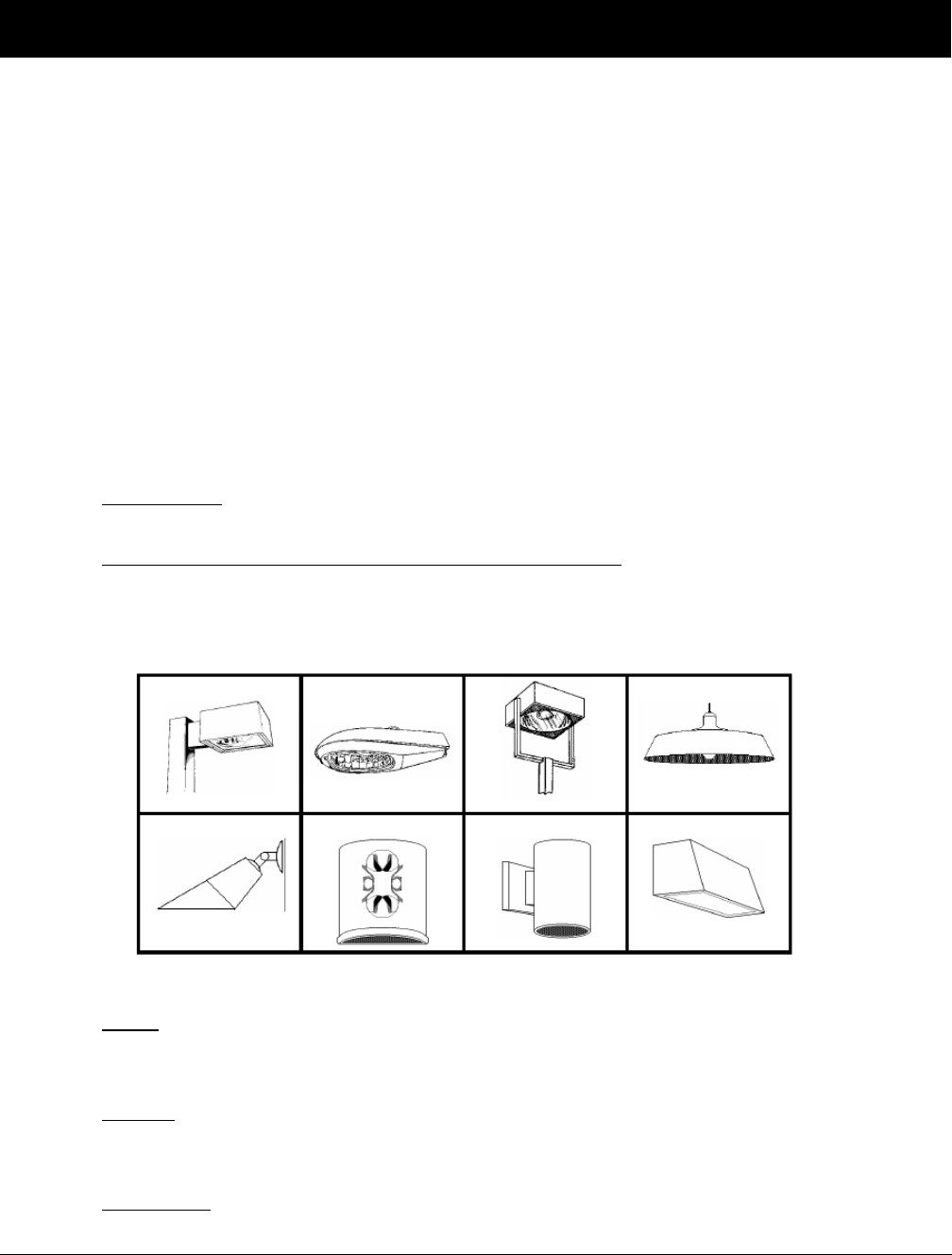
Oldham County Comprehensive Zoning Ordinance
Division 310 Lighting Regulations
224
DIVISION 310 LIGHTING REGULATIONS
Sec. 310-010 Purpose and Intent
The purpose and intent of this Division is to appropriately regulate outdoor lighting in Oldham County to
minimize the effects of light pollution, glare, and light trespass, to save energy, and to provide a safe
nighttime environment for pedestrians, motorists, and properties while protecting the public’s ability to
view the night sky.
Sec. 310-020 Applicability
The lighting regulations contained herein shall apply to all exterior lighting and to interior lighting to the
extent that it impacts the outdoor environment including lighted signs. In the event of conflict between
the regulations set forth in this Division and any other applicable regulations, the more stringent limitation
and requirement shall govern.
Sec. 310-030 Definitions
1. Foot-Candle: A quantitative unit of measurement equal to one lumen per square foot measured
at ground level.
2. Fully-Shielded Light Fixture (also known as Full Cutoff): A light fixture constructed in such
a manner that all light emitted by the fixture, either directly from the lamp or a diffusing
element, or indirectly by reflection or refraction from any part of the fixture, is projected below
the horizontal plane. The following are examples of fully-shielded light fixtures:
3. Glare: The effect produced by a light source within the visual field that is sufficiently brighter
than the level to which the eyes are adapted, to cause annoyance, discomfort or loss of visual
performance and ability.
4. IESNA: The Illuminating Engineering Society of North America, a non-profit professional
organization of lighting specialists that has established recommended design standards for
various lighting applications.
5. Illuminance: The area density of the luminous flux incident at a point on the surface. It is a
measure of light incident on a surface, expressed in lux or foot-candles.

Oldham County Comprehensive Zoning Ordinance
Division 310 Lighting Regulations
225
6. Light Fixture (Luminaire): A complete lighting unit consisting of a lamp or lamps and
ballasting (when applicable) together with the parts designed to distribute the light, to position
and protect the lamps, and to connect the lamps to the power supply.
7. Light Pollution: Any adverse effect of manmade lighting; light where it is not needed or
wanted; and wasted light.
8. Light Trespass: Light from an artificial light source that is intruding into an area where it is
not wanted or does not belong.
9. Lumen: A quantitative unit measuring the amount of light emitted by a light source.
Sec. 310-040 General Requirements:
All public and private outdoor lighting shall meet the following standards:
1. Light fixtures, except as otherwise permitted herein, are required to be fully shielded (full
cutoff). Fully-shielded light fixtures result in a light distribution pattern where no light is
permitted at or above a horizontal plane at the bottom of the fixture.
2. Light fixtures shall be installed and maintained in a manner consistent with the intended
application and as approved in the lighting plan. Fully-shielded light fixtures may not be
tilted or aimed in a manner that results in light distribution above the horizontal plane.
3. Lighting associated with canopies, including but not limited to fuel islands, seasonal outdoor
sales areas, shopping malls, theaters, drive-through bays of any kind, hotels and pavilions
shall meet the following additional standards:
a. All light fixtures mounted on or recessed into the lower surface of canopies shall be
fully shielded and utilize flat lenses;
b. All light emitted from the canopy shall be substantially confined to the ground
directly beneath the perimeter of the canopy.
c. The level of lighting shall not exceed fifty (50) foot-candles at any point beneath a
canopy.
d. No lighting of any kind, except as permitted by sign regulations, shall be allowed on
the top or sides of a canopy.
4. Exterior sports or recreational facilities (public or private) may use any light fixtures
permitted by this Division provided all of the following conditions are met:
a. Light fixtures shall be fully shielded.
b. The height of the post shall not exceed 50 feet.
c. All lights used for the purpose of illuminance of the playing area shall be turned off
following the conclusion of the final event of the night. The remainder of the facility
lighting, except for reasons of security, shall be turned off within one hour after the
event and remain extinguished until on hour prior to the commencement of the next
event.
d. Illumination of any playing area within five-hundred (500) feet of any residential use
shall not be permitted between 11:00 p.m. and 7:00 a.m. unless an event normally
expected to end before 11:00 p.m. is prevented from concluding at such time due to
specific circumstance.
e. Exterior sports or recreational facilities shall submit a lighting plan for review and
approval by the Planning and Zoning Commission. The plan shall document the
effect of lighting on adjacent residential areas. The Planning and Zoning

Oldham County Comprehensive Zoning Ordinance
Division 310 Lighting Regulations
226
Commission may require modification of the lighting plan or impose conditions on its
approval as necessary to mitigate the impacts of the lighting.
5. Illuminance of a parking lot shall meet the following additional conditions:
a. Light fixtures shall be fully shielded.
b. The use of horizontal lamps is recommended for pole mounted light fixtures in
parking lots.
c. The maximum parking lot pole height (includes base and fixture) shall be:
i. 24 feet when fixture is located within 75 feet of the site’s boundary; and
ii. 40 feet when the fixture is located beyond 75 feet from the site’s boundary
provided that for mounting heights in excess of 24 feet, the distance of the
fixture to the site’s boundary is not less than three times the mounting height.
iii. 14 feet when a non-residential property is adjacent to a residential or
agricultural zoning district or use.
d. A maximum of two light fixtures per pole is recommended for parking lots not
exceeding two hundred (200) stalls except for perimeter lighting, which should be
limited to one fixture per pole.
e. When a parking lot adjoins a residential zoning district or residential use, all light
fixtures shall be fitted with shielding on the residential side to reduce the impact of
light trespass and glare.
f. Illumination Levels: Open parking lots should be lit to meet current standards issued
by the Illuminating Engineering Society of North America (IESNA). The following
guidelines should be used:
Highest Activity Levels
Medium Activity Levels
Low Activity Levels
Typical Activities
fast food restaurants
gas stations
convenience stores
cultural/institutional
facilities
community shopping centers
hospital parking areas
educational facilitates
banks, other services
local merchants
industrial employee parking
multi-family parking lots
Average maintained
illumination levels
2.0-3.0 footcandles
1.0-2.0 footcandles
.05-1.0 footcandles
Uniformity Ratios
3:1 average/minimum
(.66 f.c minimum)
12:1 maximum/minimum
(8.0 f.c. maximum)
3:1 average/minimum
(.33 f.c minimum)
12:1 maximum/minimum
(4.0 f.c. maximum)
4:1 average/minimum
(.125 f.c minimum)
15:1 maximum/minimum
(2.5 f.c. maximum)
Maximum light at property
boundary adjoining a
residential zoning district or lot
containing a residential use
0.5 (one-half) footcandle
0.5 (one-half) footcandle
0.5 (one-half) footcandle
Maximum light at property
boundary adjoining a
nonresidential zoning district or
lot containing a nonresidential
use or at the right-of-way line
1 .0 footcandle
1 .0 footcandle
1 .0 footcandle
6. Illumination of a building façade to enhance architectural features may be permitted.
Downlighting is preferred, provided wall-mounted fixtures are used and illuminance is
contained completely within the vertical face of the building and does not spill off the
building edge. Uplighting may be permitted provided no illuminance escapes the façade.
Building facades may be illuminated to a maximum of 20 foot-candles as measured on the

Oldham County Comprehensive Zoning Ordinance
Division 310 Lighting Regulations
227
façade. Lights mounted on poles for the purpose of illuminating the building façade are not
permitted.
7. Pedestrian facilities (sidewalks, paths, etc.) including area leading from a building to parking
facilities shall not exceed an average lighting level of two and one-half (2.5) foot-candles.
Light fixtures for pedestrian facilities shall not be mounted higher than fifteen (15) feet from
the finished grade of the walking surface.
8. Bollards, or similar light fixtures that do not exceed four feet in height, intended to illuminate
landscape features or walkways, may be permitted as part of the overall lighting plan. The
total combination of lamps shall not exceed 900 lumens per bollard or light fixture. A
maximum of two fixtures per bollard and one lamp per fixture is recommended.
9. Illumination of a flag on a flagpole is permitted provided a narrow spread light fixture is used
and aimed to only illuminate the top of the flagpole. The top of the light fixture must be
shielded in a manner so as not to be visible from adjoining properties.
10. The source of light from any fixture, including interior fixtures visible through windows,
shall not create disability glare on adjoining properties.
11. All lights, except those required for security as provided herein, shall be reduced to security
levels within one hour after the end of business until one hour prior to the commencement of
business. Security lighting at entrances, stairways and loading docks, as well as limited
parking lot lighting, is permitted. The use of motion sensors for security lighting is strongly
encouraged. Security lighting shall comply with all applicable provisions contained herein.
12. The level of lighting resulting from light fixtures installed on a subject site shall not exceed:
a. one-half (0.5) foot-candle at any property line adjoining a residential zoning district
or a lot containing a residential use; and/or
b. one (1.0) foot-candle at any property line adjoining a nonresidential zoning district or
lot containing a nonresidential use or at the right-of-way line.
c. Maximum of eight (8.0) footcandles anywhere on site.
13. If the existing light level at any property boundary exceeds the maximum footcandle prior to
the development of a site, then the level of lighting resultant from luminaries installed on that
site shall not increase the light level at the property boundary by more than one-half
footcandle.
Sec. 310-050 Exceptions
1. Airport lighting for air traffic control and warning purposes. All other lighting at airports,
including that used for loading areas, hangars, terminal aprons, parking areas, etc., shall
conform to all applicable standards of this Division.
2. Traffic lights and other lighting for public safety on streets and ways.
3. Temporary use of low-wattage lighting for public festivals or events, and the observance of
holidays.
4. Lighting required temporarily for emergency purposes or repairs in the right-of-way.
5. Lighting of less than 2,400 lumens (2,400 lumens is equal to about 180 watts of an
incandescent lamp; and about 28 watts of a high-pressure sodium lamp) per fixture for
single-family detached residential areas and agriculture areas, except as prohibited herein.
Sec. 310-060 Sign Lighting
1. All signage must comply with the sign regulations in the Oldham County Comprehensive
Zoning Ordinance.
2. All lighted signs shall also comply with the provisions of this Division.

Oldham County Comprehensive Zoning Ordinance
Division 310 Lighting Regulations
228
3. Signs may be internally illuminated, backlit, or illuminated by downlighting or by ground-
mounted light fixtures that illuminate the sign face and base only.
4. Illumination of the sign face by ground-mounted light fixtures shall not exceed 50 foot-
candles as measured on the sign face.
5. It is suggested that the design of internally illuminated cabinet signs consist of lighter
lettering on a darker background in order to maximize visibility.
Sec. 310-070 Prohibited Lighting:
The following is a list of lighting that is prohibited except when used by civil authorities for public
safety, health and welfare.
1. Blinking, flashing or changing intensity lights including those proposed for signage.
2. Lighting of a type, style, or intensity determined to interfere with the safe flow of traffic.
3. Strobe lights, searchlights, beacons and laser light, or similar upward- or outworking-oriented
lighting.
4. Exposed neon, exposed LED, or similar exposed lighting.
5. Lighting creating a public hazard, including lighting that creates disability glare, particularly
where such disability glare has a detrimental effect on motor vehicle traffic.
6. Light fixtures mounted on poles for the purpose of illuminating the building façade.
7. High-intensity floodlighting except as approved for sports facility lighting.
8. Fixtures with drop or sag lens lighting.
9. Any lighting that shines directly on an adjoining property.
Sec. 310-080 Lighting Plan Requirements
The Planning and Zoning Commission may seek assistance from a professional lighting engineer to
evaluate lighting plans. The applicant shall pay costs associated with such a review.
Category 1 Development Plan
Prior to the approval of any Category 1 Development Plan, the applicant shall submit a lighting plan that
complies with the provisions of this division. Compliance with the approved lighting plan shall be
determined following a site inspection that includes field verification of light levels.
A lighting plan shall be depicted on a site plan, indicating the location of each current and proposed
outdoor lighting fixture and include the following:
1. Identification of all light fixture locations including notations on whether they are pole-,
ground- or building-mounted.
2. Mounting height with distance noted to the nearest property line for each luminaire.
3. Elevation of the poles and fixtures, and position of the lamp within the fixture.
4. Type and number of luminaire fixtures. A copy of the manufacturers catalog sheet, which
includes photographs of the fixtures, including the certified cut-off characteristics, product
number, and IESNA-type description.
5. Lamp source type (bulb type, i.e. high pressure sodium), lumen output, and wattage for each
fixture.
6. Description of light-level-reduction controls for each fixture or grouping of fixtures and
resulting after-hours light levels.
7. A note stating that no substitutions, additions, or changes may be made without prior
approval of Oldham County Planning & Development Services.

Oldham County Comprehensive Zoning Ordinance
Division 310 Lighting Regulations
229
8. Such additional information as the Planning and Zoning Administrator may determine is
necessary to ensure compliance with this Division.
Category 2 & 3 Development Plan
Prior to the approval of any Category 2 and 3 Development Plan, Non-residential use abutting a
residential or agricultural use, or Multi-family Preliminary Plan, the applicant shall submit a photometric
plan that complies with the provisions of this division. Submittal and drawings shall be signed by a
licensed professional engineer or architect taking responsibility for the design. The name and company
information for the plan preparer shall be clearly stated on the submittal drawings. Compliance with the
approved photometric plan shall be determined following a site inspection that includes field verification
of light levels.
A photometric plan shall be depicted on a site plan, indicating the location of each current and proposed
outdoor lighting fixture, and include the following:
1. Footcandle distribution, plotting the light levels in footcandles on the ground for the entire lot
and at least ten feet beyond the project property lines, at the designated mounting heights for
the proposed fixtures. Maximum illuminance levels should be expressed in the footcandle
measurements on a grid of the site showing footcandle readings in every five or ten-foot
square. The grid shall include light contributions from all sources (i.e. pole mounted, wall
mounted, sign, and street lights).
2. Identification of all light fixture locations including notations on whether they are pole-,
ground- or building-mounted.
3. Mounting height with distance noted to the nearest property line for each luminaire.
4. Total square feet of areas to be illuminated.
5. The plan must include a key to the proposed lighting that provides the following information:
a. Type and number of luminaire fixtures. A copy of the manufacturers catalog sheet,
which includes photographs of the fixtures, including the certified cut-off
characteristics, product number, and IESNA-type description.
b. Lamp source type (bulb type, i.e. high pressure sodium), lumen output, and wattage
for each fixture.
c. Elevation of the poles and fixtures, and position of the lamp within the fixture.
d. Description of light-level-reduction controls for each fixture or grouping of fixtures,
proposed hours when each fixture will be operated, and resulting after-hours light
levels.
6. Photometric calculations providing the following statistics:
a. Average to minimum;
b. Uniformity ratio of maximum to minimum;
c. Average foot-candles;
d. Minimum footcandles;
e. Maximum footcandles.
7. A note stating that no substitutions, additions, or changes may be made without prior
approval of Oldham County Planning & Development Services.
8. Such additional information as the Planning and Zoning Administrator may determine is
necessary to ensure compliance with this Division.

Oldham County Comprehensive Zoning Ordinance
Division 310 Lighting Regulations
230
Sec. 310-090 Inspections of Site, Building or Sign Lighting Installation
1. When inspecting light fixtures the inspector shall do a visual evaluation to determine whether
the fixture meets the requirements established in the provisions of this Division.
2. When inspecting light trespass complaints, the inspector shall use an IESNA approved
instrument to take a foot-candle reading to determine whether the light brightness exceeds the
standards. The inspector shall stand at the property line and hold the detector approximately
three (3) feet off the ground. The average of the vertical and horizontal measurements shall be
used to determine compliance with applicable standards.
Sec. 310-100 Nonconforming Uses
No light fixture which was lawfully installed prior to the enactment of this Division shall be required to
be removed or modified except as expressly provided herein. However no modification or replacement
shall be made to a nonconforming fixture unless the fixture thereafter conforms to the provisions of this
Division. In the event that an outdoor lighting fixture is abandoned (discontinuation of use for a period
of six months) or is damaged to the point of requiring repairs for safe operation, the repaired or
replacement fixture shall comply with the provisions of this Division.
Sec. 310-110 Permits and Waivers
Upon application, the Planning and Zoning Commission may grant a waiver of requirements of this
Division.

Oldham County Comprehensive Zoning Ordinance
Division 320 Access Management Regulations
231
DIVISION 320 ACCESS MANAGEMENT REGULATIONS
Sec. 320-010 Intent and Applicability
This division presents design guidelines for managing vehicular access to land development, while
preserving traffic flow in terms of safety, capacity and speed. Major thoroughfares and collectors serve
as the primary network for moving people and goods. These corridors also provide access to businesses
and homes and have served as the focus for commercial and residential development. The design
principles described herein are intended to balance the right of reasonable access to private property with
the right of the citizens of Oldham County to safe and efficient travel.
Sec. 320-020 Relationship to the Comprehensive Plan
This division is intended to assist in implementing the Goals, Objectives and Plan Elements of the
Comprehensive Plan.
Sec. 320-030 Access Classification System and Standards
A. The Administrator, in consultation with the County Engineer,Kentucky Transportation Cabinet
and other appropriate permitting agencies, is responsible for approving the number and location of
curb cuts. The permitting agency issues encroachment permits in accordance with the design
principles presented in this division, AASHTO standards and good engineering practice.
B. Roadway maps within Oldham County are classified for the purposes of access management as
shown in the map, “Roadway Classification and Projected Corridors.”
C. Separation between access points on all County maintained roadways should meet or exceed the
following minimum standards for that classification.
D. Table 1: Oldham County Access Classification System & Standards*
Functional
Classification
Driveway
Spacing
Spacing of Median
Openings or Major
Intersections**
Signal
Spacing
Arterial
600 ft.***
400 ft.****
1,200 ft.***
600 ft.****
¼ mile
Collector
300 ft.
300 ft. to 600 ft.
¼ mile
* It is recognized that some locations, due to existing development characteristics, may not meet the standards
provided in this section. Access to such properties is allowed to continue.
** Applies to full median openings on roadways with medians. Directional median opening spacing shall be ¼ mile
on all major arterials.
*** Applies to facilities with a speed of 45 mph or greater. Speed refers to posed speed or 85
th
percentile speed,
whichever is lower.
**** Applies to facilities with a speed of less than 45 mph. Speed refers to posted speed or 85
th
percentile speed,
whichever is lower.
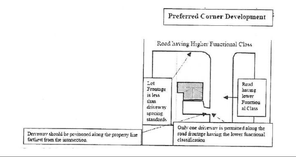
Oldham County Comprehensive Zoning Ordinance
Division 320 Access Management Regulations
232
1. To provide reasonable flexibility in administration, some deviation from access spacing standards
may be permitted, if the Administrator finds that a property is otherwise unable to meet minimum
driveway spacing standards and allowing such a deviation would not create a safety hazard on the
public road.
a. Deviation from the driveway spacing will not create a public safety hazard;
b. A joint-use driveway will be established wherever feasible, to serve to abutting building sites,
with cross-access easements provided in accordance with Section 320-050;
c. The building site is designed to provide cross access and unified circulation with abutting sites;
d. The property owner shall agree to close any pre-existing curb-cuts that are nonconforming on
the building site, after the construction of both sides of the joint-use driveway.
Sec. 320-040 Corner Clearance
A. Locate new driveways outside the functional area of an intersection, as defined by the driveway
spacing standards of this article. Exceptions to this standard may be approved if the Administrator
finds that:
1. No other reasonable access to the property is available, including joint and cross access
with adjacent properties, and
2. The connection does not create a safety or operation problem, upon review of a site-specific
study for the proposed connection prepared by a qualified professional.
B. If the permitting agency finds that no other alternatives exist and provided appropriate site distance
standards are met, a driveway within the functional area of the intersection may be constructed. It
shall be located as close to the property line and as far from the intersection as site conditions
allow. Only one driveway will be permitted and it shall access the road frontage from the street
having the lower functional classification, unless the Administrator determines that this would
create a safety or operational problem on the public street system.
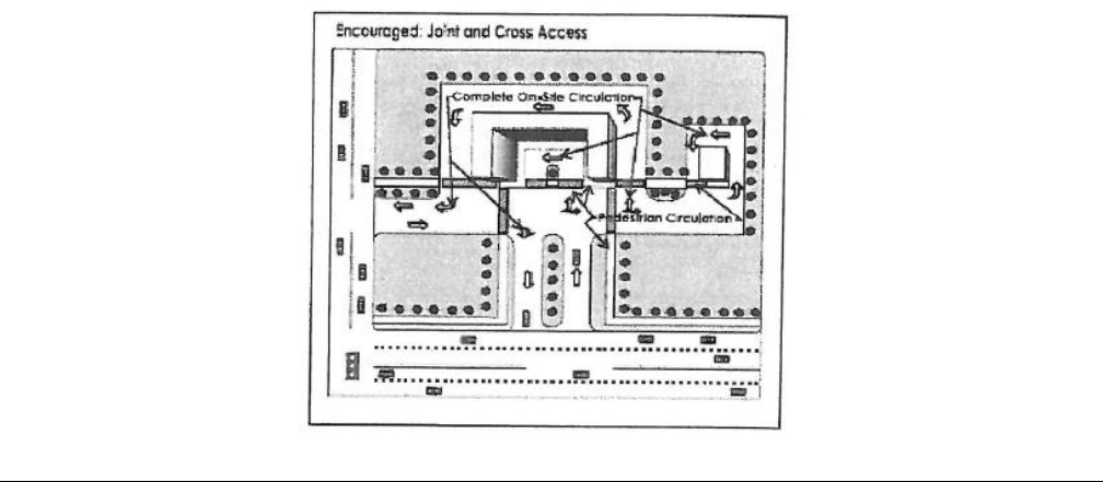
Oldham County Comprehensive Zoning Ordinance
Division 320 Access Management Regulations
233
Sec. 320-050 Joint and Cross Access
A. Properties located on arterial or collector roadways should provide a cross access drive and
pedestrian access to allow circulation between adjacent sites. Such connection is generally
required in retail commercial use adjacent to other commercial, office, industrial or multi-family
developments.
B.
Required cross-access corridors shall be shown on any subdivision or site plan. A system of joint
use driveways and cross-access easements shall be required to provide unified access and
circulation among parcels and assist in local traffic movement. In such cases, the building site
shall incorporate the following
:
1. A continuous cross-access or service drive with sufficient width to accommodate two-way
travel aisles for automobiles, service vehicles, and loading areas.
2. Stub-outs and other design features to make it visually obvious that abutting vacant
properties should be tied in to provide cross-access at the time they are developed.
3. Building sites shall be designed to ensure parking, access and circulation may be easily
tied in to future adjacent development.
C. Where joint and cross-access is provided pursuant to this section, property owners shall:
1. Record an easement in the office of the Clerk of Oldham County Kentucky, allowing cross-
access to and from other properties served by the joint use driveways or service drive,
which shall be a covenant running with the land;
2. Record an agreement in the office of the Clerk of Oldham County Kentucky that any pre-
existing curb-cuts providing for access in the interim shall be closed and eliminated after
construction of the joint-use driveway, which shall be a covenant running with the land;
3. Record a joint maintenance agreement in the office of the Clerk of Oldham County
Kentucky defining maintenance responsibilities of property owners that share the joint use
driveway and cross access system, which shall be a covenant running with the land.
4. Items described in paragraphs 1-3, above, shall be recorded prior to requesting a building
permit; if no new construction, the items shall be recorded before requesting a certificate
of occupancy.
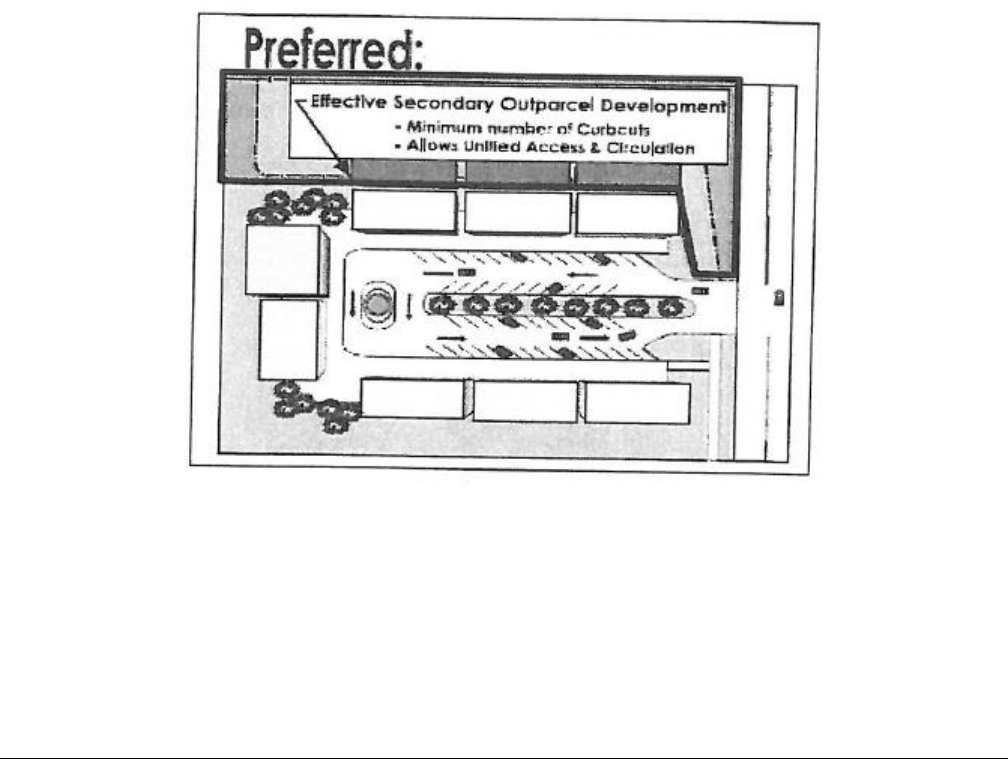
Oldham County Comprehensive Zoning Ordinance
Division 320 Access Management Regulations
234
Sec. 320-060 Requirements for Unified Access and Circulation
A. In the interest of promoting unified access and circulation systems, integrated development sites
comprised of more than one building or more than one lot are not considered separate properties
in relation to the access management standards of this code. This will also apply to phased
development plans. In addition, the following standards apply:
1. The number of curb cuts permitted shall be the minimum number necessary to provide
reasonable access to the overall site and not the maximum available for that frontage.
Reasonable access shall be determined by the Administrator.
2. All necessary easements, agreements, and stipulations required under Section 1.5 (c) shall be
met. Subsequent owners and lessees within the affected area are responsible for compliance
with these requirements.
3. Outparcels should be accessed via the shared circulation system of the principal development
or retail center. Access to outparcels should be designed to avoid excessive movement across
parking aisles and queuing across surrounding parking and driving aisles.
B. Where abutting properties are in different ownership and not part of an overall development plan,
cooperation between the various owners to create a unified access and circulation system is
encouraged. Abutting properties shall provide unified access and circulation at the time that they
are developed, or are redeveloped as provided in Section 320-080.
Sec. 320-070 Driveway Location and Design
A. Sight distance at driveway approaches must be located and designed in conformance with
appropriate AASHTO, ITE and other applicable standards.
B. The permitting agency may require deceleration or storage lanes where deemed necessary due to
traffic volumes, speed limits, or where there may be a safety or operational problem. The design
of left-turn and right-turn deceleration/storage lanes shall conform to appropriate agency
standards.
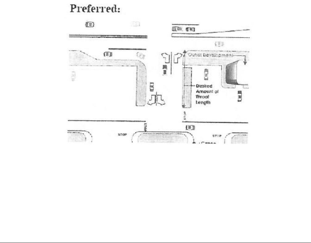
Oldham County Comprehensive Zoning Ordinance
Division 320 Access Management Regulations
235
C. Due to the potential for vehicular weaving conflicts and crashes, construction of driveways along
acceleration or deceleration lanes, left turn storage lanes and tapers is to be avoided, unless no
other access to the property is available.
D. Driveways across from median openings should be consolidated wherever feasible, to coordinate
access to the median opening.
E. Driveways on undivided roadways should be aligned directly opposite driveways on the opposite
side of the road, or offset from each other in accordance with applicable County of State Highway
Standards, due to the potential for conflicting left turns or jog maneuvers and resulting safety or
operational problems.
F. Driveway width and return radius or flare shall be adequate to serve the volume of traffic and
provide the efficient movement of vehicles onto and off of the major thoroughfare. However, the
width of driveways shall not be so excessive as to pose safety hazards for pedestrians and
bicycles. The Administrator may
require longer radii and/or wider throats where deemed
necessary to accommodate trucks.
G. Driveways with more than two lanes should incorporate channelization features. Double-yellow
lines may be considered instead of medians where truck off-tracking is a problem.
H. Driveways shall be designed with adequate on-site storage for entering and existing vehicles.
Sec. 320-080 Redevelopment
Access connections to roadways in place as of the date of the adoption of this article that do not conform
with the standards herein are considered nonconforming. Properties with nonconforming connections
should be brought into compliance with this article as changes to the roadway design allow or when an
existing development is changed in any of the following ways (a site plan is filed):
A. Existing structure is replaced by new structure or improvements;
B. An addition/expansion that will contain more than 2,500 square feet of building/structure area;
C. A new parking area is established;

Oldham County Comprehensive Zoning Ordinance
Division 320 Access Management Regulations
236
D. Existing structure or parking area is expanded by more than twenty (20) percent of more beyond
the size existing at the effective date of this regulation (incremental changes that cumulatively
increase the size by twenty (20) percent fall within the regulated activities of this paragraph);
E. An addition/expansion that will contain more than fifty (50) percent of the original square footage
of the building/structure area for sites one-half acre or less;
F. An existing use is changed to a use for which the Zoning Ordinance specifies a higher parking
ratio.
See Section 390 for complete details on site plan requirements.
Sec. 320-090 Corridor Access Management Overlay Zones
A. Segments of a roadway corridor may be designated as corridor access management zones for the
purpose of applying special access management controls that exceed the requirements and
standards in this article. The purpose of this designation is to avoid significant traffic congestion
problems, reduce vehicular and pedestrian conflict areas, and to ensure appropriate development
within the designated area in accordance with the Oldham County Comprehensive Plan.
B. The controls in such districts are not intended to be substituted for other general zoning district
provisions but can be superimposed over such district provisions and should be considered
additional requirements.
C. Corridor access management zones shall be designated and approved in accordance with the public
involvement and public hearing requirements of Oldham County that govern the creation of all
land use designations and zoning districts.
Sec. 320-100 Access to Homes and Subdivisions
A. When a residential subdivision is proposed that abuts an arterial or collector roadway, it shall be
designed to provide lots abutting the roadway with access only from an interior local road or
frontage road.
B. Direct driveway access to individual one and two family dwellings on arterial and collector
roadways are prohibited unless the Planning Commission determines that there is no acceptable
access alternative.

Oldham County Comprehensive Zoning Ordinance
Division 330 Exceptions and Modifications
237
DIVISION 330 EXCEPTIONS AND MODIFICATIONS
Sec. 330-010 Height Requirements
1. The height requirements as prescribed in these regulations shall not apply except as noted in (3)
below to belfries, chimneys, church spires, conveyors, cooling towers, elevator bulkheads, fire towers,
flag poles, monuments, ornamental towers and spires, smoke stacks, scenery lofts, tanks, and water
towers.
2. Except as noted in (3) below, public, semi-public or public services buildings, hospitals,
educational institutions, or schools may be erected to a height not exceeding forty-five feet (45’),
and churches and temples may be erected to a height not exceeding seventy-five feet (75’) when
permitted in a district with a lower height regulation, provided the required yards are each increased
one foot for each one foot of additional building height above the height regulations for the district.
3. No building or structure of any kind may be built or erected so as to project into the “glide angle
space” of any officially established airport runway, as determined by current FAA Landing Space
Requirements.
Sec. 330-020 Yard Requirements
1. In any district where the average depth of existing front yard of the nearest existing buildings, located
within one hundred feet (100’) on each side of a lot and within the same block as such lot, is greater than
prescribed by this ordinance, then in such cases the depth of the front yard on such lot shall not be less
than the average depth of said existing front yards. If there is only one such building within one hundred
feet (100’), the depth shall not be less than the average depth of the front yard of such building and the
depth specified in this ordinance for the district or area in which the lot is located.
2. Where forty percent (40%) or more of the frontage on one side of a street between two intersecting
streets or where forty percent (40%) or more of the frontage within two hundred feet (200’) of a lot
(when an intersecting street is at a greater distance) is improved with buildings which have observed an
average front yard with a variation in depth of not more than ten feet (10’), which is more or less than
the required front yard for the district, any building hereafter erected or altered in this block shall not be
located closer to the front property line than this established line. This regulation shall not be interpreted
to require a front yard in excess of sixty feet (60’).
3. On double frontage lots, the required front yard shall be provided on each street.
4. When a commercial or industrial zoned property abuts a residential zoned property, the more restrictive
setback applies to any shared property line.
5. Whenever a lot abuts an alley, one-half (1/2) of the alley width may be considered as a portion of the
required yard.
6. Every part of required yard shall be open to the sky except as authorized by this section and the ordinary
projection of sills, belt courses, cornices, and ornamental features, which may project a distance not to
exceed thirty inches (30”) into the required yard.
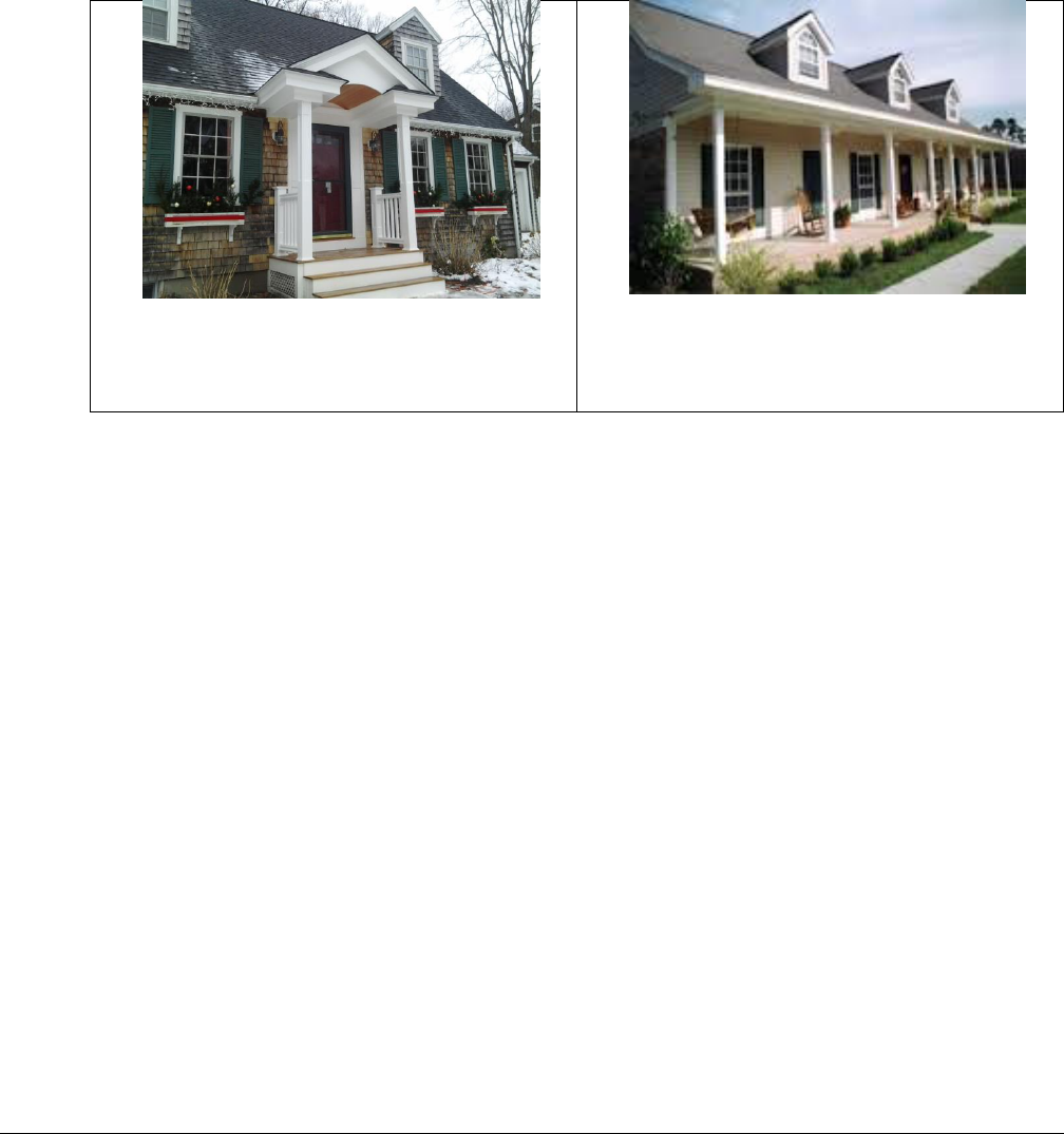
Oldham County Comprehensive Zoning Ordinance
Division 330 Exceptions and Modifications
238
7. Free-standing gasoline pumps and pump islands at vehicle service stations may occupy the required
front and street side yards, provided however, that they are not less than fifteen feet (15’) from property
lines.
8. An open, unenclosed, unroofed porch, deck or paved terrace may project into a required front yard or
required rear yard a distance of not more than ten feet (10’). Roofed entry porches not exceeding fifty
(50) square feet in coverage area and not projecting more than five (5) feet from the structure shall be
allowed.
Roofed entry porch which would be
allowed to project up to five feet.
Full covered front porch, all of which must
be behind required setback.
9. A porte-cochere or canopy may project into a required side yard provided every part of such porte-
cochere or canopy is unenclosed and shall not be less than five feet (5’) from the lot line.
10. For the purpose of the side yard regulations, a two-family dwelling, or a multiple-family dwelling, shall
be considered as one building occupying one lot.
11. Open or lattice-enclosed fire escapes, outside stairways, balconies opening upon fire towers, and the
ordinary projections of chimneys and flues into the rear yard may be permitted by the Building Inspector
for a distance of not more than five feet (5’), but only where the same are placed so as not to obstruct
light and ventilation.
12. In the R-4 District or any location where constructed, the least dimension of a side yard on which the
principal entrances or exits of a multiple-family dwelling face shall be twenty feet (20’).
13. It shall be unlawful to erect, enlarge or reconstruct any building or addition thereto on property lying
within a building setback required yard except as permitted by the appropriate Board of Adjustments
after a public hearing.
Sec. 330-040 Sight Triangle
On any corner lot in all districts there shall be no obstruction to traffic visibility within thirty-five feet
(35’) of the intersection of the two street property lines of the corner lot.

Oldham County Comprehensive Zoning Ordinance
Division 330 Exceptions and Modifications
239
Sec. 330-050 Sell-Off Approval (Future Rights-of-Way Reservation)
In the interest of public convenience, safety, welfare, and to accommodate the improvement of existing
narrow state, county, and city roads where probable new development will occur, all landowners
proposing to sell-off any portion of their existing properties fronting on said roads shall be required to
dedicate to public use, to accommodate future road improvements, sufficient road rights-of-way along the
frontage of any proposed sell-off to provide for one- half of a sixty foot (60’) road rights-of-way in front
of the sell-off.
Sec. 330-060 Water Supply and Sewage Disposal
Other than agricultural and accessory buildings without water supply, it shall be unlawful to construct any
building in any zoning district without proper sanitary facilities approved by the appropriate agency. The
use of septic tanks or other on-site systems will not be allowed unless such is contained on a lot or parcel
of one acre or more.
A property owner can build on existing platted lots of less than one (1) acre if the Health Department
approves sewage treatment and the lot size and proposed building otherwise meet zoning district
requirements.
Where multifamily units are allowed by this Ordinance, the required lot area for such units without
sanitary sewers shall be no less than one-fourth acre (10,890 square feet) per unit. No multifamily
structure, however, shall be placed on a lot without sewers that is less than one acre in size. The Oldham
County Health Department shall review all on-site waste disposal systems for multifamily units. Health
Department approval is required and may impose stricter standards than those stated here due to soil types
or other limitations.
Wherever water or sewer mains are accessible, buildings shall be connected to such mains. A new building
shall not be occupied until water and sewer facilities are in working order.

Oldham County Comprehensive Zoning Ordinance
Division 340 Antenna Towers for Telecommunications Services or Personal Communications Services
240
DIVISION 340 ANTENNA TOWERS FOR TELECOMMUNICATION
SERVICES OR PERSONAL COMMUNICATIONS SERVICES
Sec. 340-010 Planning Commission Review Required
An antenna tower for telecommunications services or personal communications services may be allowed
in any district after receiving Planning Commission review and approval in accordance with this section.
The Commission may approve the proposed antenna tower only upon finding that the proposal complies
with the Comprehensive Plan and the zoning regulations, including this section. Reasonable attempts
to co-locate additional transmitting or related equipment are required.
Any request for review of a proposal to construct or co-locate such an antenna tower shall be made only
in accordance with this section. If the property is subject to an existing approved development plan or
to an existing Conditional Use Permit, the property owner shall obtain approval of the appropriate
amendment or modification request. Such request shall be filed simultaneously with the antenna tower
for telecommunications services or personal communications services request filed pursuant to this
section. The property owner shall be responsible for making alternative provisions for any alteration
of the district development plan or Conditional Use Permit or shall obtain a variance or waiver of
the specific plan or Permit requirement affected by the location of the tower on the site.
Sec. 340-020 Documentation
Every utility or a company that is engaged in the business of providing the required infrastructure to a
utility the proposes to construct an antenna tower for telecommunications services or personal
communications within Oldham County shall submit a completed form application to the Commission
which shall include the following:
1. A grid map showing the location of all existing telecommunication antenna towers and indicating
the general position of proposed construction sites for new telecommunication antenna towers
within an area that includes:
a. All of the planning unit’s jurisdiction; and
b. A one-half (0.5) mile area outside the boundaries of the planning unit’s jurisdiction, if that
area contains either existing or proposed construction sites for telecommunication antenna
towers.
2. The full name and address of the applicant;
3. The applicant’s articles of incorporation, if applicable;
4. A geotechnical investigation report, signed and sealed by a professional engineer registered in
Kentucky, including boring logs and foundation design recommendations;
5. A written report, prepared by a professional engineer or land surveyor, of findings as to the
proximity of the proposed site to flood hazard areas;
6. Directions from the county seat to the proposed site, including highway numbers and street names
if applicable, with the telephone number of the person who prepared the directions;

Oldham County Comprehensive Zoning Ordinance
Division 340 Antenna Towers for Telecommunications Services or Personal Communications Services
241
7. The lease or sale agreement for the property on which the tower is proposed to be located, except
that, if the agreement has been filed in abbreviated form with the County Clerk, an applicant may
file a copy of the agreement as recorded by the County Clerk, and, if applicable, the portion of
the agreement demonstrating compliance with KRS 100.987(2);
8. The identify and qualifications of each person directly responsible for the design and construction
of the proposed tower;
9. A site development plan that shows the proposed location of the tower and all easements and
existing structures within five hundred (500) feet of the proposed site on the property on which
the tower will be located, and all easements and existing structures within two hundred (200) feet
of the access drive, including the intersection with the public street system;
10. A vertical profile sketch of the tower, signed and sealed by a professional engineer registered in
Kentucky, indicating the height of the tower and the placement of all antennas;
11. The tower and foundation design plans and a description of the standard according to which the
tower was designed, signed, and sealed by a professional engineer registered in Kentucky;
12. A map, drawn to a scale no less than one inch equals two hundred feet (1”=200’), that identifies
every structure and every owner of real estate within five hundred (500) feet of the proposed
tower;
13. A statement that every person who, according to the records of the Property Valuation
Administrator, owns property within five hundred (500) feet of the proposed tower or property
contiguous to the site upon the tower is proposed to be constructed, has been:
a. Notified by certified mail, return receipt requested, of the proposed construction which notice
shall include a map of the location of the proposed construction;
b. Given the telephone number and address of the local planning commission; and
c. Informed of his or her right to participate in the Commission’s proceedings on the application;
14. A list of the property owners who received the notice, together with copies of the certified letters
sent to the listed property owners;
15. A statement that the Chief Executive Officer of the affected local governments and their
legislative bodies have been notified, in writing, of the proposed construction;
16. A copy of the notice sent to the Chief Executive Officer of the affected local governments and
their legislative bodies;
17. A statement that:
a. A written notice, of durable material at least two feet by four feet in size, stating the “[Name
of Applicant] proposed to construct a telecommunications tower on this site” and including
the address and telephone numbers of the applicant and the Commission, has been posted and
shall remain in a visible location on the proposed site until final disposition of the application,
and
b. A written notice, at least two feet by four feet in size, stating that “[Name of Applicant]
proposes to construct a telecommunications tower near this site” and including the address
and telephone numbers of the applicant and the Commission, has been posted on the public
road nearest the site;

Oldham County Comprehensive Zoning Ordinance
Division 340 Antenna Towers for Telecommunications Services or Personal Communications Services
242
18. A statement that notice of the location of the proposed construction has been published in a
newspaper of general circulation in the county in which the construction is proposed;
19. A brief description of the character of the general area in which the tower is proposed to be
constructed, which includes the existing land use for the specific property involved;
20. A statement that the applicant has considered the likely effects of the installation on nearby land
uses and values and has concluded that there is no more suitable location reasonably available
from which adequate service to the area can be provided, and that there is no reasonably available
opportunity to locate its antennas and related facilities on an existing structure, including
documentation of attempts to locate its antennas and related facilities on an existing structure, if
any, with supporting radio frequency analysis, where applicable, and a statement indicating that
the applicant attempted to locates its antennas and related facilities on a tower designed to host
multiple wireless service providers’ facilities or on an existing structure, such as a
telecommunications tower or other suitable structure capable of supporting the applicant’s
antennas and related facilities; and
21. A map of the area in which the tower is proposed to be located, that is drawn to scale, and that
clearly depicts the necessary search area within which the antenna tower should, pursuant to radio
frequency requirements, be located.
Sec. 340-030 Notice
Written notice of the meeting at which the applicant to construct an antenna tower will be considered
shall be given to the owner of every parcel of property adjoining at any point or across the street from
the property on which the antenna tower is proposed to be constructed at least ten (10) calendar days
prior to the meeting.
Sec. 340-040 Procedure
After an applicant’s submission of a completed uniform application to construct an antenna tower, the
Commission shall:
1. Review the uniform application in light of its agreement with the Comprehensive Plan and the
Zoning Regulations;
2. Make its final decision to approve or disapprove the uniform application; and
3. Advise the applicant in writing of its final decision within sixty (60) days commencing form the
date that the completed uniform application is submitted to the Commission or within a date
certain specified in a written agreement between the Commission and the applicant. If the
Commission fails to issue a final decision within sixty (60 ) days and if there is no written
agreement between the Commission and the applicant to a specified date for the Commission to
issue a decision, the uniform application shall be deemed approved. If the Commission
disapproves of the proposed construction, it shall state the reasons for disapproval in its written
decision and may make suggestions which, in its opinion, better accomplish the objectives of the
Comprehensive Plan and Zoning Regulations. No permit for construction of a telecommunication
or personal communications services antenna tower shall be issued until the Commission
approves the uniform application of the sixty (60) day time period has expired and the

Oldham County Comprehensive Zoning Ordinance
Division 340 Antenna Towers for Telecommunications Services or Personal Communications Services
243
Commission has failed to issue a decision. The Commission may require the applicant to make
a reasonable attempt to co-locate additional transmitting or related equipment. The Commission
may provide the location of existing telecommunication antenna towers on which the
Commission deems the applicant can successfully co-locate its transmitting and related
equipment. If the Commission requires the applicant to attempt co-location, the applicant shall
provide the Commission with a statement indicating that the applicant:
a. Successfully attempted to co-locate on towers designed to host multiple wireless service
providers’ facilities or existing structures such as a telecommunications tower or another
suitable structure capable of supporting the applicant’s facilities, and that identifies the
location of the tower or suitable structure on which the applicant will co-locate its
transmission and related facilities; or
b. Unsuccessfully attempted to co-locate on towers designed to host multiple wireless service
provider’s facilities or existing structures such as a telecommunications tower or another
suitable structure capable of supporting the applicant’s facilities. The state shall include:
i. The location of the towers or other structures on which the applicant has attempted to co-
locate; and
ii. The reasons why the co-location attempts were unsuccessful in each instance.
4. The Commission may deny a uniform application to construct a telecommunication antenna tower
based on an applicant’s unwillingness to attempt to co-locate additional transmitting or related
equipment on any new or existing towers or other structures. Upon the approval of an application
for the construction of a telecommunication antenna tower by the Commission, the applicant shall
notify the Public Service Commission within ten (10) working days of the approval.
5. The notice to the Public Service Commission shall include a map showing the location of the
construction site. If an applicant fails to file notice of an approved uniform application with the
Public Service Commission, the applicant shall be prohibited from beginning construction on the
telecommunication antenna tower until such notice has been made.
Sec. 340-050 Guarantee of Removal in Case of Abandonment
Any contact with an owner of property upon which a telecommunication antenna tower is to be
constructed shall provide a provision that specifies, in the case of abandonment, the method that will be
followed for dismantling and removing a telecommunications antenna tower, including a timetable for
removal. To insure the removal of all improvements at any abandoned telecommunications facility, any
applicant filing a request under this section shall, at the time of submittal of the list of existing towers,
deposit with the Commission and to the benefit of the Commission a letter of credit, a performance bond,
or other security acceptable to the Commission in the amount equal to the cost of the demolition and
removal of the telecommunications tower. An applicant having multiple towers within Oldham County
may deposit a single guarantee in the amount equal to the cost of demolition and removal of the one
telecommunications tower it owns which would cost the most to demolish and remove until such time as
the number of its towers exceeds four (4) such facilities, both existing and projected within the current
calendar year. At such time as the approved number of an applicant’s towers exceeds four (4) such
facilities, the applicant shall increase the amount on deposit to an amount equal to the cost of the most

Oldham County Comprehensive Zoning Ordinance
Division 340 Antenna Towers for Telecommunications Services or Personal Communications Services
244
costly demolition and removal times twenty-five (25) percent of that applicant’s total number of towers
both existing and projected within the next calendar year. Any guarantee submitted shall be irrevocable
and shall provide for the Commission to collect the full amount of the guarantee if the applicant fails to
maintain the guarantee.
Sec. 340-060 Special Expert Consultants and Costs
The Commission may retain special expert consultants as it deems necessary to provide assistance in the
review of site location alternative analysis. Application fees may be established to cover the costs of
staff and/or special expert consultant review of requests filed under this section, within any limits
established by KRS Chapter 100.
Sec. 340-070 Confidentiality
With the exception of the amp or other information that specifically identifies the proposed location of
the telecommunication antenna tower then being reviewed, all other information contained in the uniform
application and any updates shall be recognized as confidential and proprietary within the meaning of
KRS 61.878. The Commission shall deny any public request for the inspection of such information,
whether submitted under Kentucky’s Open Record Act or otherwise, unless ordered to disclose such
records by a court of competent jurisdiction or unless confidentiality is waived in writing by the applicant.
Sec. 340-080 Design Standards
At the time of filing of a request under this section, the applicant shall provide information demonstrating
compliance with the requirements listed below. Waivers of the following standards may be requested by
the applicant and granted by the Commission in accordance with the provisions of these Zoning
Regulations.
1. All structures, except fences, shall be located at least fifty (50) feet from the property line of any
residentially zoned property and shall, in other circumstances, observe the yard requirements of
the district in which they are located.
2. The outside perimeter of the security fence surrounding the antenna tower shall be provided with
a landscape buffer. The buffer is to be a minimum of twenty (20) feet in width and contain a
continuous evergreen screen that will achieve a minimum of twenty (20) feet in height.
3. Any monopole, guyed, lattice, or similar type telecommunication antenna tower and any
alternative telecommunication antenna tower structure similar to these towers, such as light poles,
shall be maintained in either galvanized steel finish or be painted light gray or light blue in color.
Alternate sections of aviation orange and aviation white paint may be used ONLY when the FAA
finds that none of the alternatives to such marking are acceptable.
4. A telecommunication antenna tower or alternative telecommunication antenna tower structure
may be constructed to a maximum height of two hundred (200) feet regardless of the maximum
allowed height for the district in which it is located. This also applies to any tower taller than
fifteen (15) feet constructed on top of another building, with the height being the overall height
of building and tower together measured from the grade to the highest point. When any
telecommunication antenna tower or alternative telecommunication antenna tower structure is

Oldham County Comprehensive Zoning Ordinance
Division 340 Antenna Towers for Telecommunications Services or Personal Communications Services
245
taller than the distance from its base to the nearest property line, the applicant shall furnish the
Commission with a certification from an engineer registered in the Commonwealth of Kentucky
that the tower will withstand winds of seventy (70) miles per hour in accordance with
ANSI/EA/TAI standards. When a tower taller than fifteen (15) feet constructed on top of another
building results in the overall height of the building and tower, including any antenna, being
greater than the distance from the base of the building to the nearest property line, the applicant
shall furnish to the Commission this same certification.
5. A telecommunication antenna tower or alternative telecommunication antenna tower structure
may be artificially lighted ONLY with steady-burning red obstruction lights (FAA type L-810)
or flashing red obstruction lights (FAA type L-864) flashing no faster than twenty (20) flashes
per minute. Flashing red obstruction lights (FAA type L-864) flashing faster than twenty (20)
flashes per minute, medium intensity flashing white obstruction lights (FAA type L-865 or L-
866), high intensity flashing white lights (FAA type L-856 or L-857), or dual flashing red
obstruction lights and medium intensity flashing white obstruction lights (FAA types L-864/L-
865) may be used ONLY when the FAA specifies that the specific lighting pattern is the ONLY
lighting pattern acceptable to promote aviation safety.
6. The site shall be unstaffed. Personnel may periodically visit the site for maintenance, equipment
modification, or repairs. To accommodate such visits, access shall be only from access points
approved by the applicable Works Department, and there shall be provided on site an area
sufficient to accommodate the parking of the service vehicle.
7. The site shall be enclosed by an eight (8) foot high security fence, and the fence may be located
in any required yard at any height, but not in the sight triangle described in Section 240-180.
8. Any site to be purchased or leased for the installation of a telecommunication antenna tower or
alternative telecommunication antenna tower structure and ancillary facilities shall comply with
the minimum lot size requirements of the district in which the site is located.
9. The facility shall comply with the FCC’s regulations concerning radio frequency emissions. To
the extent that the facilities do not comply with the FCC’s regulations, the Commission may
establish additional requirements on the basis of the environmental effects of radio frequency
(See P.L. 104-104, sec. 704).
10. If the use of any telecommunication antenna or telecommunication antenna tower or alternative
telecommunication antenna tower structure is discontinued, the owner shall provide the
Commission with a copy of the notice to the FCC of intent to cease operations within thirty (30)
days of such notice to the FCC. If the telecommunication antenna or telecommunication antenna
tower or alternative telecommunication antenna tower structure will not be reused, the owner
shall have one hundred eighty (180) days from submittal of the FCC notice to the Commission to
obtain a demolition permit and remove the antenna or tower that will not be reused. If the
telecommunication antenna or telecommunication antenna tower or alternative
telecommunication antenna tower structure is to reused, the owner shall no more than twelve (12)
months from submittal to the FCC notice of the Commission in which to commence new
operation of the antenna or tower to reused. Upon failure to commence new operation of the
antenna or tower that is to be reused within twelve (12) months, the telecommunication antenna

Oldham County Comprehensive Zoning Ordinance
Division 340 Antenna Towers for Telecommunications Services or Personal Communications Services
246
or telecommunication antenna tower or alternative telecommunication antenna tower structure
shall be presumed abandoned, and the owner shall immediately obtain a demolition permit and
remove the antenna or tower that is presumed abandoned. If the owner fails to remove an antenna
or tower in the time provided by this paragraph, the Commission may cause the demolition and
removal of the antenna or tower recover its costs of demolition and removal from the Guarantee
deposited by the applicant pursuant to this section.
11. The only signs allowed shall be emergency information signs, owner contact information,
warning or safety instructions, and signs required by a federal, state or local agency. Such signs
shall not exceed five (5) square feet in area.

Oldham County Comprehensive Zoning Ordinance
Division 350 Boards of Adjustments
247
DIVISION 350 BOARDS OF ADJUSTMENTS
This Division is written for the express purpose of re-establishing a Board of Adjustments in accordance
with Kentucky Revised Statutes (KRS) Section 100.217 and in accordance with other portions of this
ordinance. While the original intent and purpose of this Division is to create a body whose jurisdiction is
all of Oldham County, the right to local governments to create their own Board of Adjustments and to
modify such provisions as number of members, meetings and their procedure is hereby not affected. While
it is recognized that some cities have Boards of Adjustments in existence at this time, a city may elect to
dissolve the existing Board of Adjustments and utilize the county Board of Adjustments, or a city may
elect to reorganize the existing Board in accordance with KRS 100.217 and this ordinance, or the existing
Board may continue to function in accordance with this ordinance. In any event, no land in Oldham
County shall have two Boards of Adjustments with the same or overlapping jurisdiction and Municipal
Boards of Adjustments are limited to the corporate limits of said municipality.
Sec. 350-010 Authorization
A Board of Adjustments for the administration of this ordinance with Kentucky Revised Statues, Section
100.217. Board of Adjustments shall consist of five (5) members, all of whom must be citizen members.
Nominations for the Board of Adjustments shall be made by the county judge-executive and approved by
the Fiscal Court. The filling of vacancies, taking oaths, and removal from office shall be only as provided
in KRS 100.217. Board of Adjustments shall annually elect a chairman, vice chairman, secretary, and any
other officers it deems necessary. Any officer shall be eligible for re-election at the expiration of their
term.
Sec. 350-020 Meetings and Procedures
1. Board of Adjustments shall conduct meetings at the call of the chairman or Administrator who
shall give written or oral notice to all members of Board of Adjustments at least seven (7) days
prior to the meeting, which notice shall contain the date, time, and place for the meeting, and the
subject or subjects which will be discussed.
2. Quorum and Conflict of Interest. A simply majority of the total membership of a Board of
Adjustment as established by regulation or agreement shall constitute a quorum. Any member of
a Board of Adjustment who has direct or indirect financial interest in the outcome of any question
before the body shall disclose the nature of the interest and shall disqualify himself from voting
on the question.
3. By-Laws, Minutes, Records. Board of Adjustments shall adopt by-laws for the transaction of
business and shall keep minutes and records of all proceedings, including regulations, transactions,
findings, and determinations and the number of votes for and against each questions, and if any
member is absent or abstains from voting, indicating the fact, all of which shall, immediately after
adoption, be filed in the office of the Administrator. Such records shall be provided if requested

Oldham County Comprehensive Zoning Ordinance
Division 350 Boards of Adjustments
248
by a party, ten (10) days prior to the hearing, at the expense of the requesting party, and the
transcript shall constitute the record.
4. A court reporter may be requested by the applicant or board at least ten (10) days prior to the
hearing who shall be designated and paid by the applicant. The original transcript shall be
delivered to the Board of Adjustments.
Sec. 350-030 Appeals
1. The Board of Adjustments shall have the power to hear and decide cases where it is alleged by an
applicant that there is error in any order, requirement, decision, grant or refusal made by an
administrative official in the enforcement of the zoning regulations. Such appeal shall be taken
within thirty (30) days.
2. Appeals to the Board of Adjustments may be taken by any person, or entity claiming to be
injuriously affected or aggrieved by an official action, order, requirement, interpretation, grant,
refusal, or decision of any zoning enforcement officer. Such appeal shall be taken within thirty
(30) days after the appellant or his agent receives notice of the action of the official by filing with
said officer and the Board a notice of appeal specifying the grounds thereof, and giving notice of
such appeal to any and all parties of record. Said officer shall forthwith transmit to the Board all
papers constituting the record upon which the action appealed from was taken and shall be treated
as and be the respondent in such further proceedings. At the public hearing on the appeal held by
the Board, any interested person may appear and enter his appearance, and all shall be given an
opportunity to be heard.
3. Board of Adjustments shall fix a reasonable time for hearing the appeal and give public notice in
accordance with KRS Chapter 424, as well as written notice to the appellant and the administrative
official at least one (1) week prior to the hearing and shall decide it within sixty (60) days. The
affected party may appear at the hearing in person or by attorney.
Sec. 350-040 Powers of Board of Adjustments
When approving any application, the Board of Adjustments may impose such additional conditions as it
deems necessary to safeguard the public welfare, safety, health, convenience, and best interests of the
adjoining property and neighborhood.
Board of Adjustments shall have the following powers:
1. Interpretation and Administrative Review. To hear and decide cases where it is alleged by an
applicant that there is error in any order, requirement, decision, grant, or refusal made by an
Administrative Official in the enforcement of this regulation, and for the interpretation of the
Zoning Map. Such appeal shall be taken within sixty (60) days of the action of the Board of
Adjustments.

Oldham County Comprehensive Zoning Ordinance
Division 350 Boards of Adjustments
249
2. Dimensional Variance. To hear and decide cases in which an existing lot of record is too small
to allow fulfillment of the minimum dimensional or yard requirement of the district in which the
property is located. Board of Adjustments shall not possess the power to grant a variance to permit
a use on any land, building or structure which is not permitted by the zoning regulation in the zone
in question. For variance applications, all adjoining property owners shall receive notice by first
class mail. In addition, publication of the application, as prescribed by KRS Chapter 424, shall be
followed.
Before any variance is granted, Board of Adjustments must find all of the following, which shall
be recorded along with any imposed conditions or restrictions in its minutes and records:
a. The manner in which the strict application of the provisions of the regulation would deprive
the applicant of a reasonable use of the land in the manner equivalent to the use permitted other
landowners in the same zone.
b. That the unique conditions and circumstances are not the result of actions of the applicant taken
subsequent to the adoption of the zoning regulations.
c. Reasons that the variance will preserve, not harm the public safety and welfare, and will not
alter the essential character of the neighborhood.
A dimensional variance applies to the property for which it is granted, and not to the individual
who applied for it. A variance also runs with the land and is transferable to any future owner of
the land, but it cannot be transferred by the applicant to a different site.
3. Conditional Use. To hear and decide applications for conditional use permits to allow the proper
integration into the community of uses which are specifically named in the zoning regulations but
which may be suitable only in specific locations in the zone and only if certain conditions are met.
Board of Adjustments may approve, modify, or deny any application for a conditional use permit.
If it approves such a permit, it may attach necessary conditions such as time limitations,
requirements that one or more things be done before the request can be initiated, or conditions of
a continuing nature. Any such conditions shall be recorded in the Board of Adjustments’ minutes
and on the conditional use permit along with a reference to the specific section of the zoning
regulations listing the conditional use under consideration. The Board of Adjustments shall have
power to revoke conditional use permits or variances for noncompliance with the condition
thereof. Furthermore, the Board of Adjustments shall have a right of action to compel the violator
to remove offending structures or uses at his/her own costs and may have judgment in personam
for such cost.
The Administrator shall review all conditional use permits, except those for which all conditions
have been complied within a previous review. The Administrator is given the power to inspect
the land or structure where the conditional use is located in order to ascertain that the landowner
is complying with all of the conditions which are listed on the conditional use permit. If the

Oldham County Comprehensive Zoning Ordinance
Division 350 Boards of Adjustments
250
landowner is not complying with all of the conditions listed on the conditional use permit, the
Administrator shall report the fact in writing to the chairman of the Board of Adjustments. The
report shall state specifically the manner in which the landowner is not complying with the
conditions listed on the conditional use permit, and a copy of the report shall be furnished to the
landowner at the same time that it is furnished to the chairman of the Board of Adjustments. Board
of Adjustments shall hold a hearing on the report and the date of the hearing, the Board of
Adjustments may authorize the Administrator to revoke the conditional use permit and take
necessary legal action to cause the termination of the activity on the land which the conditional
use permit is authorized.
Once the Board of Adjustments has completed a conditional use permit and all the conditions
required are of such type that they can be completely and permanently satisfied, the Administrator,
upon request of the applicant, may if the facts warrant, make a determination that the conditions
have been satisfied and the conclusion in the margin of the copy of the conditional use permit
which is on file with the County Clerk, as required in KRS 100.344 at the expense of the applicant.
Thereafter, said use, if it continues to meet the other requirements of the regulations, shall be
treated as a permitted use.
4. Uses Not Specifically Permitted in Zoning Districts. The Board of Adjustments shall have the
power to determine which uses are of the same general characters as uses specifically permitted in
zoning districts and thus allow sues in zoning districts which, although not specifically permitted,
will not be out of character with other uses in the district.
Board of Adjustments may grant variances on appropriate applications from any part of these
regulations as long as that variance is not in conflict with other requirements or limitations set out in
this section.

Oldham County Comprehensive Zoning Ordinance
Division 360 Building Permits and Fees
251
DIVISION 360 BUILDING PERMITS AND FEES
Sec. 360-010 Building Permits Required
No building or other structure shall be erected, moved, added to, or structurally altered without a permit
issued by the County Building and Inspections Department. No building permit shall be issued except in
conformity with the provisions of this regulation, unless the County Building and Inspections Department
receives a written order from the Board of Adjustments in the form of an administrative review,
conditional use, or variance as provided by the regulation.
If no building permit has been issued and a builder or individual begins or continues to build after a Stop
Work Order has been issued, a restraining order may be obtained upon application to the proper court of
record and evidence of the lack of a building permit shall establish a prima facie case for the issuance of
the restraining order.
Sec. 360-020 Exceptions for which Building Permits are not Required
1. Recurring maintenance regardless of cost.
2. Construction of a service connection to a public owned and operated utility.
3. A fee is not to be charged for the construction of improvements such as grading, streets, ditch
digging, cutting and filling, and the like in conjunction with site improvements prior to building
development.
4. Installation of required improvements according to an approved preliminary subdivision plat.
Sec. 360-030 Building Permit Procedure
Prior to the issuance of a building permit, all checklist items on the application must be completed and
submitted to the County Building and Inspections Department. Building permit applications shall be acted
on within a reasonable time.
Sec. 360-035 Agricultural Buildings
1. Prior to the construction of all agricultural buildings, a building permit must be issued in order to
ensure compliance with all property development regulations.
2. Building permits for agricultural buildings will not be assessed an application fee unless
inspections are requested.
Sec. 360-040 Construction Equipment
No construction vehicles,equipment or materials shall be parked for more than twenty-four (24) hours on
any publicly dedicated subdivision street or county road while being used in the construction of any
building or addition thereto.

Oldham County Comprehensive Zoning Ordinance
Division 370 Administration, Enforcement and Penalties
252
DIVISION 370 ADMINISTRATION, ENFORCEMENT AND PENALTIES
Sec. 370-010 Administration
This ordinance shall be administered and enforced by the Director who may be a member of the
Commission and who shall be appointed by the County Judge-Executive subject to the approval of Fiscal
Court. The salary of the Director shall be determined in the same manner.
The County shall pay all members of the Commission in an amount determined by the Fiscal Court. The
County shall bear all legal, administrative and enforcement expenses for all areas outside incorporated
areas. The County shall have such powers as defined by KRS 100 and other laws contact with all
incorporated cities in the county for joint administration and enforcement of all regulations adopted by
Fiscal Court. Each incorporated city that contracts with the county shall have the right to maintain its own
Board of Adjustments.
The Board of Adjustments shall hear and decide appeals where it is alleged by the appellants that there is
error in any ordinance, requirement, permit, decision, determination, or refusal made by the Director or
other administrative official in the enforcement of any provision of this ordinance.
The county may contract with professional planners, architects, attorneys, land surveyors and engineers
to assist in the administration and enforcement of these regulations and any other resolutions relating to
planning and zoning.
Sec. 370-020 Code Enforcement
1. Any person, firm, corporation, or entity that violates any of the provisions of these regulations
upon conviction shall be fined according to the adopted ordinance vilaotion fine schedule.
2. The Commission shall have such power as provided by KRS 100.337, and other applicable laws,
to enforce these regulations.
Sec. 370-030 Compliance with Zoning Ordinance and Subdivision Regulations
Any conflict between the terms and provisions contained in either the Comprehensive Zoning Ordinance
or Subdivision Regulations when compared to the other shall be resolved by the Commission at its
discretion, provided that those conflicts identified by KRS 100 shall be interpreted in a way that is least
restrictive to the property owner. The Comprehensive Zoning Ordinance shall be deemed a part of the
Subdivision Regulations, the same as if fully copied therein, and the Subdivision Regulations shall be
deemed a part of the Comprehensive Zoning Ordinance the same as if copied therein.
Sec. 370-040 Administration in Incorporated Areas
It shall be the duty of the Director to inform the applicable Mayor of all violations of this ordinance within
the incorporated area which he/she represents. Expenses incurred in appeals from enforcement of this
ordinance in the incorporated areas shall be the responsibility of the city and not the county, unless
otherwise agreed.

Oldham County Comprehensive Zoning Ordinance
Division 370 Administration, Enforcement and Penalties
253
Sec. 370-050 Real Estate Sell-Off
No real estate sell-off from any existing land may be recorded until a plat of proposed sell-off has received
zoning administration approval. Administration approval will not be granted until appropriate application
for a Dimensional Variance has been filed should the sell-off not meet existing zoning requirements, or
should the sell-off have a remaining tract of real estate that has dimensions that do not meet existing
zoning regulation requirements.

Oldham County Comprehensive Zoning Ordinance
Division 380 Zoning Map Amendment Procedures and Development Plan Requirements
254
DIVISION 380 ZONING MAP AMENDMENT PROCEDURES AND DEVELOPMENT PLAN
REQUIREMENTS
Sec. 380-010 Application Process
Applications for amendments to the Zoning Map shall be made only in accordance with this section.
A. Initation of Amendment
Applications for amendment of the zoning map shall be filed with the Commission. Map Amendment
applications may be initiated by the Commission or any legislative body within the county having
zoning authority over an affected property or the owner. When requested, the Commission shall
provide the applicant with appropriate application forms.
B. Exemptions
Applications for amendment to the Zoning Map, which are initiated by the Commission or the
legislative body having zoning authority over the affected property, shall be exempt from the
development plan and binding elements section of this ordinance.
C. Pre-application Conference
Prior to formal application for amendment of the zoning map, the applicant or his agent shall have a
conference with the Commission staff to discuss the effect of the Comprehensive Plan, the Zoning
Regulations, the Subdivision Regulations, and other land development controls would have on the
proposed development. It is intended that the conferees discuss apparent characteristics of the site that
would affect the proposed development and also discuss what elements may be required on the
preliminary development plan of the proposed project.
D. Neighborhood Meeting and Techincal Review Committee Meeting
Based on the information presented and discussion at the pre-application meeting, as well as
information gleamed from the Zoning Ordinance, a concept development plan is to be prepared to
facilitate discussion with planning staff and neighbors as well as utility providers. This concept
development plan isn’t required to meet the standard for rezoning. It needs only contain or convey
information in a format necessary to show the intentions of the development.
At this stage a meeting with identified neighbors is required to facilitate the identification and potential
resolution of community concerns. The developer will need to provide the Commission staff with a
list of first tier (adjoining) property owners and second tier property owners (those adjoining first tier)
within 500 feet as well as certification that each property owner listed was notified of the meeting to
discuss the development. The developer shall submit with the development plan a sign-in sheet from
the meeting and a statement detailing issues raised at the required meeting with the neighbors and
solutions or consolations presented or proposed. A copy of the sign-in sheet and statement shall be
mailed by the developer to each identified neighbor whether present or absent at the meeting. The
development plan would then be submitted in its original or amended form for consideration by the
technical review committee. The committee shall meet on a schedule established by the Administrator
and made public.

Oldham County Comprehensive Zoning Ordinance
Division 380 Zoning Map Amendment Procedures and Development Plan Requirements
255
E. Application for Amendment
Applications for amendment of the Zoning Map shall be filed with the Commission in accordance
with the Commission’s Rules and this Section of the Zoning Regulations.
1. Demonstration of Appropriateness:
All applications for amendment to the Zoning Map shall be accompanied by the following where
applicable:
a. A statement describing how the proposed map amendment would conform to the
Comprehensive Plan.
b. A statement why the existing zoning classification of the property in question is inappropriate
or improper.
c. A statement describing what major economic, physical or social changes, if any, have occurred
in the vicinity of the property in question that were not anticipated by the Comprehensive Plan,
and which have substantially altered the basic character of the area involved. The statement
shall include the following:
i. A list of major economic, physical or social changes;
ii. A description of how said changes were not anticipated by the Comprehensive Plan;
iii. A description of how said changes altered the basic character of the area; and
iv. A description of how said changes make the proposed amendment to the Zoning Map
appropriate.
d. A statement describing how utilities and essential public services will be provided to the
property in question;
e. A description of the anticipated time period in which implementation of the proposed uses will
be initiated provided the amendment is approved.
2. Property Owners’ Signature:
Unless made by the Commission or a legislative body, all applications for amendment to the
Zoning Map shall be signed by the owner(s) of the affected property. Leaseholders, option holders,
developers, and agents should also be identified.
3. Responsibility for Accuracy:
The applicant shall be held responsible for the accuracy of the information submitted by him as
part of the Zoning Map Amendment application.
Sec. 380-020 Development Plan
A. Development Plan Submission
All applications for any proposed amendment to the Zoning Map shall include a development plan in
accordance with the provisions and requirements of this section.
The Development Plan is intended to demonstrate to the Commission the character and objectives of
the proposed development in adequate detail for the Commission to evaluate the effect the proposed

Oldham County Comprehensive Zoning Ordinance
Division 380 Zoning Map Amendment Procedures and Development Plan Requirements
256
development would have on the community and determine what provisions, if any, should be included
as part of the development plan and be binding on the use and development of the subject property.
The elements included in the Development Plan shall be determined in accordance with paragraph D
below.
B. Development Plan Alternative
A preliminary subdivision plan submitted in conjunction with a proposed Zoning Map amendment for
the purpose of creating a single family residential subdivision, shall be accepted in lieu of a
development plan.
C. Agreement to Development Plan Conditions
The filing of an application for any Zoning Map amendment shall constitute an agreement by the
owner and applicant, their heirs, successors, and assigns that if the Zoning Map amendment is enacted
by the legislative body having zoning authority over the property in question, building permits for the
improvement of any such property shall be issued only when applications for the permits show the
proposed buildings in conformance with the binding elements of the approved development plan for
the property. The binding elements described herein and adopted in conjunction with any Zoning Map
change shall be strictly upheld and shall be enforceable in the same manner as the Zoning Regulations.
D. Elements of Development Plan
Unless specifically waived at a pre-application conference, the Development Plan submitted to the
Commission or legislative body involved at its public hearing on the requested Zoning Map change
shall contain all of the following elements in graphic or written form.
1. Existing topography, with a contour interval not greater than five feet (5’) unless specifically
waived. Existing topography with a contour interval less than five feet (5’), based on field survey,
may be required for all or part of the subject property as existing topographic conditions warrant.
Proposed contours may also be required;
2. Vicinity map with measurements to existing streets;
3. Boundary description, including area and bearings, and dimensions of all property lines;
4. Lot sizes within the project, location, height, floor area, and arrangement of proposed and existing
buildings;
5. The uses proposed for the subject property and the proposed use of existing structures, if any, on
the subject property;
6. Existing tree masses, significant rock out-croppings, streams, floodplains, and other natural
features;
7. Provisions for screening and buffering, landscaping, recreational, and open space area;
8. The location, arrangement, and dimensions of existing and proposed streets and driveways,
adjacent streets, sidewalks, parking areas (including number of off-street parking spaces), points
of ingress and egress, off-street loading areas, and other vehicular, bicycle or pedestrian rights-of-
ways;

Oldham County Comprehensive Zoning Ordinance
Division 380 Zoning Map Amendment Procedures and Development Plan Requirements
257
9. Provisions for handling surface water drainage and utilities information where appropriate, such
as proposals for gas, water, electricity, telephone service, sewage lines, fire hydrants, and similar
information, and the location and dimensions of other existing or proposed easements;
10. Demonstration of compliance with land use intensity requirements;
11. Proposed stages of development, if applicable, and the anticipated time required to develop each
stage;
12. Other such information the Commission or legislative body involved deems appropriate; and all
development plans shall be drawn to a sufficient scale to clearly delineate the applicant’s proposed
use and development of the subject property. Such scale shall be indicated on the development
plan.
13. The Commission or legislative body involved may, in conjunction with its hearing and prior to
making its decision on the issue of the proposed Zoning Map change, require such additional
elements it deems necessary for adequate review of the Map Change application.
E. Scope of Review
The Commission and legislative body hearing a zoning map change shall consider, but not be limited
to, the following factors in a review of a development plan:
14. The conservation of natural resources on the property proposed for development, including: trees
and other living vegetation, steep slopes, water courses, floodplains, soils, air quality, scenic views,
and historic sites;
15. The provisions for sufficient open space (scenic and recreation) to meet the needs of the proposed
development;
16. The provision for sufficient open space (scenic and recreation) to meet the needs of the proposed
development;
17. The provision for adequate drainage facilities on the subject site in order to prevent drainage
problems from occurring on the subject site or within the community;
18. The compatibility of the overall site design (location of buildings, parking lots, screening,
landscaping) and land use or uses with the existing and projected future development of the area;
19. Conformance of the development plan with the Comprehensive Plan and Zoning District
Regulations.
F. Binding Elements
The Commission and legislative body involved shall designate, at the time of approval of any zoning
map change and development plan, those elements, provisions, and restrictions of the approved plan,
if any, including a time period for development plan expiration, that shall be an integral and permanent
part of the development plan and thereby binding on the use and development of the subject property.
The items from the development plan designated as integral and permanent by the legislative body
approving the zoning map change shall be known as the “binding elements”. Items shown on the
approved development plan that are not designated by the Commission or the legislative body as an
integral and permanent part of the plan shall not be binding on the use and the development of the
subject property except as required by other provisions of the zoning ordinance.

Oldham County Comprehensive Zoning Ordinance
Division 380 Zoning Map Amendment Procedures and Development Plan Requirements
258
G. Binding Elements Run With the Land
The binding elements of a development plan approved by the Commission or legislative body shall
run with the land and be binding on the owner and applicant, their successors, heirs, or assignsm unless
otherwise amended as herein provided or released by the Commission. The “binding elements”
designed by the legislative body involved shall be recorded as an encumbrance in the County Court
Clerk’s Office.
H. Conflicts Between Binding Elements and Zoning Regulations
No binding element of a development plan approved by the Commission or legislative body shall
permit the development or use of land in a manner otherwise prohibited by the Zoning Regulations.
To the extent a binding element of a development plan may purport to grant such permission, it shall
be deemed in conflict with the Zoning Regulations and be void and of no effect.
Sec. 380-030 Zoning Map Amendment Process
A. Notice of Public Hearing
The Commission or legislative body shall give public notification of all hearings scheduled on
proposed zoning map amendments in accordance with the provisions of Kentucky Revised Statutes,
Chapters 100-424, and other applicable law.
B. Public Hearing
The Commission and legislative body shall hold a public hearing on all proposed amendments to the
Zoning Map in accordance with the provisions of Kentucky Revised Statutes, Chapters 100-424 and
other applicable law. The public hearing shall consider the appropriateness of the proposed
amendments of the zoning map and the appropriateness of the development plan for the site in
question.
A qualified court reported may be requested by the applicant or objecters at any hearing before the
Commission ten (10) days prior to the hearing. The reporter shall be paid by the applicant, or objectors,
depending upon who made the request. The applicant shall deliver the original transcript to the
Commission.
C. Planning Commission Action
Following a public hearing concerning a proposed amendment to the Zoning Map, the Commission
shall make a recommendation as to the appropriateness of the proposed Zoning Map amendment and
forward such recommendation to the legislative body having zoning authority over the property in
question. In addition, the Commission shall by separate vote approve, reject, or defer action on the
submitted development plan and “binding elements” thereof, if any. Thereafter, a copy of the proposed
development plan, its “binding elements” and the Commission’s recommendation regarding the
Zoning Map amendment shall be forwarded to the appropriate legislative body.

Oldham County Comprehensive Zoning Ordinance
Division 380 Zoning Map Amendment Procedures and Development Plan Requirements
259
The Planning Commission shall take no action on property or receive a request on property that is in
litigation for any reason until such time the litigation is resolved by final Court action. A zone change
substantially similar to one recommended for denial by the Planning Commission for any reason shall
not be resubmitted for a period of two (2) years unless ordered by a judicial court to consider an
application.
The Administrator can request the Commission determine if the development plan or preliminary plat
submitted is substantially similar to the one recommended for denial by the Planning Commission.
D. Legislative Action
1. Zoning Map Amendment:
The legislative body having zoning authority over the property in question shall, at a public
hearing, approve or deny the proposed Zoning Map amendment after receiving and considering
the Commission’s recommendations regarding the proposed Zoning Map Amendment,
development plan and “binding elements”.
2. Additional Development Plan Requirements by Legislative Body:
The legislative body hearing the proposed Zoning Map change may, with approval of the
Zoning Map change, include additional binding elements on the development plan that it
deems appropriate for the welfare of the community.
E. Notice of Enactment
Immediately after the enactment of a Zoning Map amendment by the appropriate legislative body, that
legislative body shall notify the Adminstrator of the enactment of the map amendment, the
development plan approval, and all binding elements, if any. The Commission shall maintain records
of all development plans and binding elements it and the legislative body have approved pertaining to
the enacted Zoning Map amendment. It shall be the responsibility of the Administrator to enforce the
binding elements section of this ordinance.
Sec. 380-040 Implementation of Development Plan and Zoning Regulations
A. Building Permits
Building permits for improvement of any property subject to a development plan shall be issued only
in conformance with the binding elements of the development plan (including the development plan
expiration date). Building permits issued in conflict with the binding elements of the appropriate
development plan are of no effect.
B. Development Plan Amendments
Amendments to approved binding elements, other than by a legislative body while hearing the Zoning
Map Amendment, shall require Planning Commission approval. Requests for amendments to binding
elements of any development plan shall be submitted to the Commission and the Commission shall
act thereon within ninety (90) days of the receipt thereof. Amendments shall be processed in the same

Oldham County Comprehensive Zoning Ordinance
Division 380 Zoning Map Amendment Procedures and Development Plan Requirements
260
manner as the original development plan, including legislative body approval. However, a public
hearing on the proposed amendment to the development plan shall be held only if the Commission or
legislative body, at its hearing, deems it necessary and appropriate. If a public hearing is held, the
Commission and legislative body shall give public notice of said hearing at the applicant’s expense.
Sec. 380-050 Review of Planning Commission’s Action Regarding Development Plans
A. Initiation of Review
Planning Commission denial of any Zoning Map change or proposed development plan may be
reviewed by the legislative body having zoning authority over the property in question, if said
legislative body determines that such a review is warranted. Any such review shall be conducted as a
public hearing. The owner(s) of the subject property or any aggrieved party may request such a hearing
by written letter to the appropriate legislative body stating the reason(s) why such a review is
warranted.
B. Notice
1. If the legislative body determines that a review regarding the proposed Zoning Map change and
development plan is warranted, it shall inform the Commission of the date, time, place, and subject
of the public hearing concerning the review.
2. The legislative body shall notify, by letter, all parties of record to any Planning Commission
hearing previously held regarding proposed Zoning Map change, and all owners of property
adjoining the subject property, of the date, time, place, and subject of the hearing. In addition, said
notification shall advise those notified of their right to inspect the subject plans in the Commission
Office and to present their opinion at the public hearing.
C. Public Hearing
The public hearing shall include a presentation by the applicant seeking review of the Commission’s
action pertaining to the said Zoning Map amendment, and the applicant shall state why he believes the
Commission’s action was not justified. The legislative body may hear any other witnesses and review
any other evidence at the hearing it deems appropriate.
D. Legislative Action
If the legislative body, subsequent to the public hearing, agrees with the Commission’s action, it shall
so indicate by resolution. If the legislative body disagrees with the Commission’s action, it may adopt
an ordinance changing the Zoning Map and establishing a development plan and “binding elements”.
A copy of all such resolutions or ordinances shall be forwarded, by the legislative body, to the
Commission.
E. Planning Commission Action
If the legislative body amends the Zoning Map, the Admistrator shall note the amendment and the
development plan on zoning records and issue building permits in conformance with said change.

Oldham County Comprehensive Zoning Ordinance
Division 380 Zoning Map Amendment Procedures and Development Plan Requirements
261
F. Judicial Review of Legislative Action
Judicial review of an action of the legislative body pursuant to this action must be initiated by an
aggrieved party within thirty (30) days from the time such action becomes effective

Oldham County Comprehensive Zoning Ordinance
Division 390 Site Plan Regulations
262
DIVISION 390 SITE PLAN REGULATIONS
Sec. 390-010 Applicability
Site plan approval shall be required for the following land uses prior to the issuing of building permits:
1. Residential Uses: Attached housing developments of 10 units or more.
2. Non-Residential Uses: Prior to the issuing of a building permit, site plan approval shall be obtained
for non-residential development that meet one or more of the following criteria:
a. New construction of buildings/structures, reconstruction of buildings/structures at the same
location or relocation of buildings/structures to a new on-site location;
b. An addition/expansion that will contain more than 2,500 square feet of building/structure area;
c. An addition/expansion that will contain more than 20 percent of the original square footage of
building/structure area for sites greater than one-half acre; and,
d. An addition/expansion that will contain more than 50 percent of the original square footage of
building/structure area for sites one-half acre or less.
3. Manufactured Home Park: Site plan approval shall be obtained for all new manufactured home
parks.
4. Parking Areas and Structures: Site plan approval shall be required for a parking garage, for a new
parking area or for an addition to any existing parking area resulting in an increase/expansion of
an existing vehicular use area by 20 percent before a building permit can be issued.
Sec. 390-020 Specific Information Required
Site plans shall be drawn and submitted at a scale not less detailed than one inch equals fifty feet (1 inch
equals 50 feet), or other scale acceptable to the Planning and Zoning Commission staff. All site plans
shall contain the following:
1. Name of the development and/or subdivision in which the site is situated.
2. Address and lot number of the subdivision in which the development is proposed.
3. Key map drawn to a scale of one inch equals one thousand feet (1 inch equals 1,000 feet), which
shall include streets and corporate limits within a one half (1/2) mile radius of the site.
4. Names and addresses of the owner and the applicant.
5. Names, addresses and seals (on the section of the plan that they prepare) of each professional
consultant participating in the design.
6. North arrow.
7. City and state.
8. Date.
9. Existing zoning and parcel number for the site.
10. Proposed use.
11. Name of owner(s), parcel number and zoning of adjoining properties.
12. Minimum required front, side and rear setback lines.
13. Location of the 100-year floodplains per FEMA maps, if applicable.

Oldham County Comprehensive Zoning Ordinance
Division 390 Site Plan Regulations
263
14. Location and size of wetlands, if any, meeting the Army Corps of Engineers’ jurisdictional wetland
standards.
15. Location of water bodies.
16. Existing and proposed land contours showing vertical intervals no greater than two (2) feet.
17. Bearings and distances for all boundaries of the site with notation as to whether data is based on
deeds or actual surveys.
18. Locations, square footages, and exterior dimensions, measured from outside wall to outside wall,
of all existing and proposed buildings and structures.
19. A sheet showing all proposed improvements overlaid on the existing topography indicating what
natural features will be destroyed or disrupted.
20. Existing and proposed easements with dimensions and designated types.
21. Existing and proposed locations, types and sizes of the following:
a. Water lines
b. Fire hydrants
c. Sanitary sewers
d. Stormwater infrastructure
e. Culverts
f. Street improvements
g. Sidewalks
h. Electric lines
i. Any other utilities or services affected by the site.
22. Parking layout and traffic control plan which shall include the locations, arrangements, and
dimensions of the following:
a. Vehicle entrances, exits and drives
b. Handicapped pedestrian entrances, exits, walks and ramps
c. Vehicle parking spaces
d. Widths of vehicular traffic aisles
e. Truck loading and unloading spaces and docks
f. Proposed traffic control devices
23. Location of existing and proposed signs.
24. Landscaping plan conforming to the Landscape Regulations.
25. Lighting plan conforming to the Lighting Regulations
26. Statistics for the proposed development:
a. Total lot area
b. Lot width
c. Total floor area of buildings
d. Floor Area Ration (FAR) of all uses
e. Total lot area covered by structures
f. Total lot area covered by impervious surface
g. Percentage of lot covered by impervious surface
h. Height of structures in stories and feet

Oldham County Comprehensive Zoning Ordinance
Division 390 Site Plan Regulations
264
i. Setbacks of all buildings, structures and parking area (front, side and rear yard).
27. The applicant shall provide any additional information, as determined by the Planning and Zoning
Commission staff.
Sec. 390-030 Property Owners’ Signature and Responsibility for Accuracy
All site plan applications shall be signed by the owner(s) of the affected property. Leaseholders, option
holders, developers, and agents should also be identified.
The applicant shall be held responsible for the accuracy of the information submitted as part of the site
plan applications. The applicant must be a real person or entity as defined in KRS 271B.400.
Sec. 390-040 Site Plan Review Procedure
All site plans shall be submitted to the Planning and Zoning Administrator, accompanied by filing fees,
prior to the issuance of building permits. Planning and Zoning Commission staff and the County Engineer
will review all site plan applications.
For purposes of review procedure, developments are divided into three distinct categories based upon a
traffic review completed by the Oldham County Traffic Consultant. The categories are:
A. Category 1 – Development proposal does not trigger impacts on the road network and shall
undergo review by the Zoning Administrator and Planning staff.
B. Category 2 – Development proposal that generates more than 20 peak-hour trips and will have an
entrance on a road with greater than 1,500 Average Daily Trips (ADT) shall require a traffic
assessment and shall undergo review by the Technical Review Committee.
C. Category 3 – Development proposal that generates more than 100 peak-hour trips and will have
an entrance on a road with greater than 2,000 ADT shall require a traffic impact study and shall
require approval by the Planning Commission.
The review process for each category of development is outlined below. Initial or revised submissions
shall follow the procedure determined by the new or additional development proposed unless a higher
level of review is required by another section of this ordinance. Requested waivers, variances and other
items are not appropriate for Administrative approval or Technical Review Committee approval and
shall be reviewed by the Planning Commission.
A. Category 1 Review Procedure - Zoning Administrator Approval
Prior to issuance of building permits, the Zoning Administrator shall assure the plan is in compliance
with the applicable requirements of this ordinance and all binding elements and conditions of approval.
These requirements include but are not limited to: allowable uses; setbacks; impervious surfaces; height;
landscaping; parking; and environmental assessment. The Zoning Administrator shall approve the
proposed development if it complies with the requirements of this ordinance, associated binding
elements, and other applicable law. In cases in which the Zoning Administrator has reason to question
the site plan’s compliance, the Administrator may forward the development plan to the Technical
Review Committee for review and action.

Oldham County Comprehensive Zoning Ordinance
Division 390 Site Plan Regulations
265
B. Category 2 Review Procedure – Technical Review Committee Review
The Technical Review Committee shall assure the plan is in compliance with the applicable
requirements of this ordinance including capacity standards; all binding elements and conditions of
approval; and other applicable law. In addition to the site plan application, the Category 2 development
requires a Technical Review Committee application which includes the following:
1. Complete Oldham County Planning and Zoning Technical Review Committee Application.
2. Required TRC Fee of $300, and Notice fees equal to $5.00 per adjoining property owner.
3. Mailing Labels for all adjoining property owners, including name and address of all 1
st
tier
adjoining parcels. 1
st
tier adjoining parcels include all those that border the property, including
those across streets and streams.
4. Property information for the project location as listed by the Property Valuation Administration
(PVA).
5. A copy of the current recorded deed along with any applicable easement deeds or maintenance
agreement. Include any surveys of the property, if available.
6. Twenty copies of the Site Plan, including required components listed in the attached plan
checklist (Maximum size of 30” x 42”).
7. Reduced copies of the plan to an 8 ½” x 11” size, one for each adjoining property owner.
8. Photos and other supporting documents (10 copies).
9. Traffic Assessment. See Division 270-040 Road Capacity Standards for guidance.
10. Review comments from the appropriate agencies (Agency contact list is attached to TRC
application). Note: Only the Conservation District letter is required at time of application.
11. Information from neighborhood meeting with TRC application.
All documents shall be submitted in person by the last Wednesday of the month; failure to submit all
required material may result in the delay of the application review. In cases in which the Technical
Review Committee has reason to question the site plan’s compliance, the Committee may forward the
development plan to the Planning Commission for review and action.
C. Category 3 Review Procedure – Planning Commission Review
The Planning Commission shall assure the plan is in compliance with the applicable requirements of this
ordinance including capacity standards; all binding elements and conditions of approval; and other
applicable law. In addition to the site plan application and the TRC application and review, the Category
3 development requires a Planning Commission application which includes the following:
1. Complete Oldham County Commission Application.
2. Required Preliminary Plan fee of $500 plus $5.00 per adjoining property owner.
3. Mailing labels for all adjoining property owners including name and address of all 1
st
tier
adjoining parcels. 1
st
tier adjoining parcels include all those that border the property, including
those across streets and streams, and 2
nd
tier parcels within five hundred feet of subject site.
4. Property information for the project location as listed by the Property Valuation Administration
(PVA).
5. A copy of the current recorded deed along with any applicable easement deeds or maintenance
agreements. Include any surveys of the property, if available.
6. Twenty tri-folded copies of a Preliminary Plan including the required components listed in the
attached Preliminary Plan Checklist (maximum size of 30” x 42’).

Oldham County Comprehensive Zoning Ordinance
Division 390 Site Plan Regulations
266
7. One reduced copy of the plan to an 8 ½” x 11” size.
8. Written explanation of the provisions of reservations and arrangement for maintenance of
common areas and open spaces.
9. Review comments from the appropriate agencies. Agency contact list is provided by Planning
and Development Services.
10. Traffic Impact Study (see Division 270-040 Road Capacity Standards for guidance) and 20
copies of the summary section.
11. If applicable, a general statement describing the nature of environmentally sensitive areas, and
the manner in which any such area is to be handled during development of the property, as well
as any special design measures taken by the developer to minimize the development’s impact on
the environmentally sensitive areas.
12. Photos and other supporting documents (20 copies).
13. Wastewater Treatment and Capacity Form (for developments served by sanitary sewers).
All documents shall be submitted in person by the last Wednesday of the month; failure to submit all
required material may result in the delay of the application review. Additional requests, such as
variances, waivers or zoning map amendments may be reviewed at the time of site plan review.
Sec. 390-050 Extension of Site Plan Approval
Approval of a site plan shall cease to be effective one (1) year after the date of approval if start of
construction has not begun. Prior to the expiration of a site plan, an applicant may request, in writing
from the Planning Commission, up to one (1) extension, not to exceed one year, without having to resubmit
the site plan if no changes have been made; however, if a site plan has expired, or if changes have been
made, or if the applicant wishes for the extension to be effective for greater than one (1) year, the applicant
shall be required to resubmit the site plan for approval.

Oldham County Comprehensive Zoning Ordinance
Division 400 Community Facility Review
267
DIVISION 400 COMMUNITY FACILITY REVIEW
Any approval for acquisition or disposition of land for public facilities, or changes in the character, location, or
extent of structures or land for public facilities, excluding state and federal highways and public utilities and
common carriers by rail mentioned in this section, shall be referred to the Commission to be reviewed in light of its
agreement with the Comprehensive Plan, and the Commission shall, within sixty (60) days from the date of its
receipt, review the project and advise the referring body whether the project is in accordance with the
Comprehensive Plan. If it disapproves of the project, it shall state the reasons for disapproval in writing and make
suggestions for changes which will, in its opinion, better accomplish the objectives of the Comprehensive Plan.

Oldham County Comprehensive Zoning Ordinance
Division 410 Environmental Performance Standards
268
DIVISION 410 ENVIRONMENTAL PERFORMANCE STANDARDS
RESERVED

Oldham County Comprehensive Zoning Ordinance
Division 420 Definitions
269
DIVISION 420 DEFINITIONS
For the purpose of these regulations, certain terms or words used herein shall be interpreted as follows. All words
used in the present tense include the future tense. All words in the singular include the plural, and all words in the
plural include the singular. The word “shall” is mandatory and not directory. The word “used” shall be deemed to
include “designed, intended or arranged to be used.” The word “building” shall include structure. When definitions
are included within divisions of this document, those definitions shall take precedence over definitions in this
division where differences exist.
In the event that a definition is not listed in this section or document staff shall refer to “A Planners
Dictionary” published by the American Planning Association.
Accessory Service and Retail Use – Accessory service and retail uses serving primarily (75 percent of business)
residents, clients, or employees of the principal use with which they are associated and located on the same
lot with such principal use; is subordinate in purpose, area, or extent to the principal use served; and is
located on the same building site as the principal use.
Accessory Structure – A subordinate building, the use of which is purely incidental and subordinate to that of the
main building and located on the same lot as the main building.
Accessory Use – A use customarily incidental and subordinate to the principal use or building.
Acre-foot – Acre-foot means a measure of volume equivalent to a material that is one (1) foot deep and over one
(1) acre of surface area.
Adult Day Center – A community facility that provides supervised therapeutic and medical care for senior citizens
during any part of the day, but less than twenty-four (24) hour care.
Agritourism – the act of visiting
(a) farm or ranch; or
(b) any agricultural, horticultural, or agribusiness operation; for the purpose of enjoyment, education, or
active involvement in the activities of the farm, ranch, or operation (HB 360)
Agritourism Activity – any activity that:
a) Is carried out on a farm, ranch, agricultural operation, horticultural operation, agribusiness
operation; and
b) Allows or invites participants to view or participate in activities for recreational,
entertainment, or educational purposes. Qualifying activities may include but not limited to
weddings and ancillary events; harvest-your-own operations; farmers’ markets; or natural
resource-based activities. The activities may qualify for agritourism activities whether or not a
participant pays to view or participate in the activity. (HB 360)
Agritourism Building – any building or structure or any portion thereof that is used for one (1) or more
agritourism activities. (HB 360)

Oldham County Comprehensive Zoning Ordinance
Division 420 Definitions
270
Agricultural Uses – “Agricultural use” means the use of:
(a) A tract of at least five (5) contiguous acres for the production of agricultural or
horticultural crops, including but not limited to livestock, livestock products, poultry,
poultry products, grain, hay, pastures, soybeans, tobacco, timber, orchard fruits, vegetables,
flowers, or ornamental plants, including provision for dwellings for persons and their
families who are engaged in the agricultural use on the tract, but not including residential
building development for sale or lease to the public,
(b) regardless of the size of the tract of land used, small wineries licensed under KRS
243.155,
(c) A tract of at least five (5) contiguous acres used for the following activities involving
horses:
1. Riding lessons;
2. Rides;
3. Training;
4. Projects for eductational purposes;
5. Boarding and related care; or
6. Shows, competitions, sporting events, and similar activities that are associated with
youth and amateur programs, none of which are regulated by KRS Chapter 230,
involving seventy (70) or less participants. Shows, competitions, sporting events,
and similar activities that are associated with youth and amateur programs, none of
which are regulated by KRS Chapter 230, involving more than seventy (70)
participants shall be subject to local applicable zoning regulations; or
(d) A tract of land used for the following activities involving horses:
1. Riding lessons;
2. Rides;
3. Training;
4. Projects for educational purposes;
5. Boarding and related care; or
6. Shows, competitions, sporting events, and similar activities that are associated with
youth and amateur programs, none of which are regulated by KRS Chapter 230,
involving seventy (70) or less participants. Shows, competitions, sporting events,
and similar activities that are associated with youth and amateur programs, none of
which are regulated by KRS Chapter 230, involving more than seventy (70)
participants shall be subject to local applicable zoning regulations.
This paragraph shall only apply to acreage that was being used for these activities
before July 13, 2004.
Alley – Any public or private way set aside for public travel less than twenty (20) feet in width and providing only
a secondary means of access to property abutting thereon.
Appeal – A request for a review of the Administrator’s interpretation of any provision of this ordinance or a request
for a variance.
Archaeological Site – In the Commonwealth of Kentucky, an archaeological site is defined by the Kentucky State
Historic Preservation Office as any location where human behavior has resulted in the deposition of
artifacts, or other evidence of purposive behavior at least 50 years of age. An archaeological site can be

Oldham County Comprehensive Zoning Ordinance
Division 420 Definitions
271
the remains of prehistoric or historic activities including habitation sites (prehistoric villages, camp sites,
rockshelters; historic farmsteads, sites associated with standing structures, etc.), extractive sites (prehistoric
flint quarries; historic quarries), burial sites (prehistoric mounds, cemeteries, and isolated graves; historic
cemeteries), processing sites (prehistoric tool manufacture areas; historic sites such as lime kilns, iron
furnaces, etc.), transportation sites (old road beds, early railroad beds, etc.), battlefields (pioneer or Civil
War), early forts (pioneer or Civil War) and stations (pioneer), petroglyphs (prehistoric art on rocks and
outcroppings) and many other types of remains.
Arterial Roadways – A roadway that provides for high mobility and limited access. These roadways connect urban
centers and convey traffic distances more than one mile. Arterials often connect urban centers with outlying
communities and employment.
Attached Single Family – A one-family dwelling attached to two or more one-family dwellings by common vertical
walls.
Auto Auction – A facility for the sale of automobiles to the highest bidder.
Barrel Warehouses -– Storage of distilled spirits for human consumption.
Basement – The portion of a building having its floor subgrade (below ground level) on all sides.
Bed and Breakfast – A building where, for compensation and by prearrangement for definite periods, lodging and/or
morning meals are provided for ten (10) rooms or less.
Boards of Adjustments – An officially constituted body whose principle duties are to hear appeals and, where
appropriate, grant variances from the strict application of the Zoning Ordinance.
Boarding or Lodging House – A building other than a hotel where meals or sleeping accommodations, or both, are
provided for compensation for three, but not more than twenty, persons.
Brewery – A facility for the production and packaging of malt beverages for sale, and includes all offices, granaries,
mash rooms, cooling rooms, vaults, yards, and storerooms connected with the premises that manufacture
more than fifty thousand (50,000) barrels annually.
Brewpub – An establishment where food, beer and malt beverages are duly-licensed to be made on premises. Fifty
percent (50%) or more of the beer produced on site must be sold and/or consumed on site.
Building – Any structure constructed or use for residence, business, industry or other public or private purpose, or
accessory thereto. Such as a walled and roofed building that is principally above ground, a manufactured
home, a gas or liquid storage tank, or other man-made facilities or infrastructures.
Building Elevation – A fully dimensioned drawing of the front, rear or side of a building which shows features such
as windows, doors and the relationship of grade to floor level.

Oldham County Comprehensive Zoning Ordinance
Division 420 Definitions
272
Building Envelope – The three-dimensional space within which a structure is permitted to be built on a lot and that
is defined by maximum height restrictions, and minimum yard setbacks.
Building Height – The vertical distance from finished grade to the top of the highest roof beams on a flat or shed
roof, the deck level on a mansard roof, and the average distance between the eaves and the ridge level for
gable, hip, and gambrel roofs. Building height shall be measured from the average ground level facing the
highest adjoining sidewalk or street right-of-way.
Building, Principal – A building, including covered porches, carports, and attached garages in which is conducted
the principal use of the lot on which it is situated. In any residential district any dwelling shall be deemed
to be the principal building on the lot on which the same is situated.
Building Site –A parcel of land occupied or intended to be occupied by main structures and accessory structures
and uses, together with all open spaces as are required by this ordinance.
Caliper – Measurement used to state the diameter of the trunk of a tree.
Camping Trailer – A vehicle intended for seasonal use but not for the year-round living accommodations.
Camp or Campgrounds – Tracts of land of a design or character suitable for and used seasonal, recreational and
other similar living purposes. The tracts may have located on them a structure of a seasonal, temporary or
movable nature, such as a cabin, hunting shelter, or tent. Any permanent structures such as cabins must
comply with the appropriate requirements for dwellings in that district, including requirements of the Health
Officer.
Change of Use – Any use that substantially differs from the previous use of a building or land.
Churches and Other Religious Institutions – A building, structure, group of buildings or place of worship
ceremonies, rituals, and education pertaining to a particular system of beliefs are held. Permitted accessory
uses may include schools, meeting halls, recreational facilities, day-care, counseling, and kitchens capable
of feeding hundreds of persons.
College – An education institution authorized by the state to award baccalaureate or higher degrees.
Commercial Kitchen – area where appliances are used for heating and cooking food and which produce grease
vapors, steam, fumes, smoke or odors that are required to be removed through a local exhaust ventilation
system. (2009 International Mechanical Code).
Commercial Resort – A resort furnishing lodging, meals, and such recreational facilities as swimming, boating,
shuffleboard, horseback riding, and golf. The recreational facilities shall be incidental to the furnishing of
lodging and meals.
Community Center – A facility used for a fraternal, social or recreational program, generally open to the public,
and intended to accommodate and serve significant segments of the community.

Oldham County Comprehensive Zoning Ordinance
Division 420 Definitions
273
Concentrated Animal Feeding Operation – A lot or facility where animals have been, are or will be stabled or
confined and fed or maintained for a total of forty-five (45) days or more in any twelve (12) month period
and where crops, vegetation forage growth, or post-harvest residues are not sustained over any portion of
the lot or facility in the normal growing season and there are more than three hundred (300) Animal Units
(defined by the Kentucky Division of Water) confined and there is a discharge to the Waters of the
Commonwealth, or, there are more than one thousand (1,000) Animal Units confined.
Conditional Use – A use which is essential, desirable, or would promote the public health, safety, or welfare in one
or more zones, but which would impair the integrity and character of the zone in which it is located, or in
adjoining zones, unless restrictions on location, size, extent, and character of performances are imposed in
the zoning regulation.
Conditional Use Permit – Legal authorization to undertake a conditional use issued by the administrative official
pursuant to authorization by the Board of Adjustments, consisting of two parts:
1. A summary statement of the factual determination by the Board of Adjustments, which justifies the
issuance of the permit; and
2. A statement of the specific conditions which must be met in order for the use to be permitted and
allowed to continue.
Construction Plan – A document prepared by a professional engineer licensed in the State of Kentucky showing
details concerning the construction of physical improvements for a subdivision or development including
but not limited to roads, drainage and utilities.
Craft Distillery – Production of distilled spirits for human consumption that shall not exceed fifty thousand (50,000)
proof gallons in one (1) year.
Deciduous – Foliage that sheds at the end of the growing season.
Density – The gross number of dwelling units per acre of land.
Detached Single Family – A dwelling that is not attached to any other dwelling by any means.
Development – Any man-made change to improved or unimproved real estate including, but not limited to:
buildings or other structures, mining, dredging, filling, grading, paving, excavating, drilling operations, or
permanent storage of materials and equipment.
Development Site – See “Building Site.”
Distillery – Production of distilled spirits for human consumption which are registered in the office of any collector
of internal revenue for the United States.
Dripline – A vertical projection to the ground surface from the furthest lateral extent of a tree’s leaf canopy.

Oldham County Comprehensive Zoning Ordinance
Division 420 Definitions
274
Dump – A lot or tract of land or part thereof used for the disposal by abandonment, dumping, burial, burning or
other means; of trash, refuse, junk, discarded machinery, vehicles or parts thereof, or waste materials of any
kind.
Dwelling, Single-Family – A permanent building, separate and free standing, in itself providing living
accommodations for one family.
Dwelling, Two-Family – A permanent building designed exclusively for occupancy by two families.
Dwelling, Multi-Family – A permanent building or portion thereof, providing separate living accommodations for
three or more families.
Dwelling Unit – A permanent building used primarily for human habitation but not including manufactured homes
of facilities for the housing of transient residents.
Dwelling Units per Acre (DU) – The number of dwelling units divided by the lot or tract area.
Evergreen – Foliage that remains on a plant and green throughout the year.
Farm Tour – Tourism conducted on a working farm or any other agricultural, horticultural or agribusiness operation
where the working environment forms an agricultural product.
Fire Area: – The aggregate floor area enclosed and bounded by fire walls, fire barriers, exterior walls or horizontal
assemblies of a building (2013 KBC).
Floor Area Ration (FAR) – The gross floor area of all buildings or structures on a lot divided by the total lot area.
Garbage – Any odorous, decomposable, or combustible waste materials.
Group or Row House – A group or row of not more than eight semi-detached, single-family dwellings not more
than two rooms deep, with access to a street.
Historic Site – A structure or place of outstanding historical and cultural significance and designated as such by the
federal, state or local government.
Historic Structure – Any structure that is:
1. Listed individually in the National Register of Historic Places (a listing maintained by the Department
of Interior) or preliminarily determined by the Secretary of the Interior as meeting the requirements for
individual listing on the National Register;
2. Certified for preliminarily determined by the Secretary of the interior as contributing to the historical
significance of a registered historic district;
3. Individually listed on a state inventory of historic places in states with historic preservation programs
which have been approved by the Secretary of the Interior; or
4. Individually listed on a local inventory of historic places in communities with historic preservation
programs that have been certified either: a.) By an approved state program as determined by the

Oldham County Comprehensive Zoning Ordinance
Division 420 Definitions
275
Secretary of the Interior, or b.) Directly by the Secretary of the Interior in states without approved
programs.
Home Occupation – Any use conducted entirely within a dwelling or in the immediate vicinity of the dwelling by
the occupant of the dwelling as an accessory use which is clearly incidental to the use of the dwelling for
residential purposes.
Hospital and Institutions – (1) Offers services more intensive than those required for room, board, personal services
and general nursing care. (2) Offers facilities and beds for use beyond 24 hours by individuals requiring
diagnosis, treatment, or care for illness, injury, deformity, infirmity, abnormality, disease, or pregnancy;
and (3) Regularly makes available clinical laboratory services, diagnostic X-ray services, and treatment
facilities for surgery or obstetrical care, or other definitive medical treatment of similar extent. Hospitals
may include offices for medical and dental personnel, central service facilities such as pharmacies, medical
laboratories, and other related uses.
Impervious Surface – Any material that prevents absorption of stormwater into the ground.
Intensity – Intensity refers to the floor area ration (FAR) for development.
Junk Yards – A lot, land, building, or structure, or part thereof used primarily for the collecting, storage and/or sale
of waste paper, rags, scrap metal, or discarded material, or for the collecting, dismantling, storage, and
salvaging of machinery or vehicles not in running condition, and for the sale of parts there from or scrap.
Kennel – Any place where home pets are kept for purposes other than those customary and incidental to a household.
This includes commercial establishments in which dogs or domesticated animals are housed, groomed,
bred, boarded, trained, or sold, all for a fee or compensation.
Land Under Single Ownership or Unified Control – Land that is owned by a person, by a partnership or association
of two or more persons holding a common interest or by a corporation.
Landscape Buffer Area (LBA) – A landscape buffer area (LBA), as used in these regulations, refers to the area that
must be set aside, free from development, to accommodate the required landscape and buffering materials.
No buildings or structures except fences, walls, or those structures attendant to public utility service shall
be allowed within the required LBA.
Legislative Body – The chief body of the city or consolidated local government with legislative power, whether it
is the board of alderman, the general council, the common council, the city council, the board of
commissioners, the county’s fiscal court, or otherwise.
Lineal Foot – A one dimensional measurement from one point to another point.
Loading Area – An off-street space or berth on the same lot with a building or contiguous to a group of buildings
for the temporary parking of a commercial vehicle while loading or unloading merchandise or material.

Oldham County Comprehensive Zoning Ordinance
Division 420 Definitions
276
Lot – A piece, parcel, or plot of land occupied or to be occupied by one principal building and its accessory buildings
and including the open spaces required under this regulation.
Lot Area – The total area within the lot lines of a lot.
Lot Coverage of Structures – That portion of the lot that is covered by buildings.
Lot of Record – Any lot, the deed of which is on record at the office of the County Clerk of Oldham County at the
time of enactment of this resolution.
Lot Width – The horizontal distance between the side lines of a lot measured at right angles to its depth along a
straight line parallel to the front lot line at the minimum required setback line.
Malt Beverage – Any fermented, undistilled alcoholic beverage of any name or description, manufactured from
malt wholly or in part, or from any substitute for malt, and includes weak cider.
Manufactured Home – A single-family residential dwelling constructed after June 15, 1976, in accordance with the
National Manufactured Home Construction and Safety Standards Act of 1974, 42 U.S.C. Section 5401, et
seq., as amended, and designed to be used as a single-family residential dwelling with or without permanent
foundation when connected to the required utilities, and which includes the plumbing, heating, air
conditioning, and electrical systems contained therein.
Manufactured Home (Qualified) – See Qualified Manufactured Home.
Manufactured Home Park – An area developed for the rental or lease of space for manufactured homes with
accommodations for six (6) or more manufactured homes.
Manufactured Home Subdivision – A residential subdivision designed exclusively for and occupied only by
manufactured homes, in which the homes and the land are owned by the occupants.
Mature Woodlands – An area or stand of trees whose total combined canopy covers an area of one (1) acre or more,
at least 50 percent of which is composed of trees having a diameter breast height of 24 inches or more. No
area of trees kept or grown for commercial purposes shall be considered a mature woodland.
Medical Office/Clinic – An establishment providing therapeutic, preventative, corrective, healing, and health-
building treatment services on an out-patient basis by physicians, dentists, and other practitioners. Typical
uses include medical and dental offices and clinics and out-patient medical laboratories.
Microbrewery – A facility for the production and packaging of malt beverages that manufacture fifty thousand
(50,000) barrels or less annually.
Mini Warehouses – A building or group of buildings in a controlled-access and fenced compound that contains
varying sizes of individual compartmentalized stalls or lockers with access controlled by tenant for the
storage of customer’s goods or wares. An operation involving a security arrangement utilizing a
warehouseman as provided for in Article 7 of KRS Chapter 355 is not a mini-warehouse.

Oldham County Comprehensive Zoning Ordinance
Division 420 Definitions
277
Minor Subdivision – A subdivision of land into not more than three lots within a five-year time period and not
involving a new public street or private raod in zoning districts AG-1, CO-1, T, R-1, R-1A, R-2, R-2A, R-
3, R-4, R-4A, C-N, O-1 and O-2.
Modular Homes – Any single-family, unattached, manufactured home that is without wheels and chassis but hat is
designed for transportation on streets after fabrication.
Motel or Tourist Home – Inn or group of cabins or rooms designed for occupancy by paying guests.
Motor Home – A self-propelled vehicle with year-round living accommodations constructed as an integral part of
the vehicle.
New Development – Any construction or alteration of an existing structure of land use, or establishment of land
use, after the effective date of this Zoning Ordinance.
Non-conformance – A condition that occurs when, on the effective date of adoption of this ordinance or previous
ordinance on the effective date of an ordinance text amendment or rezoning, an existing lawful lot,
structure/building, sign, development or use of an existing lot or structure does not conform to one or more
of the regulations currently applicable to the district in which the lot, structure, building, sign, development,
or use is located.
Non-conforming Uses – An activity which lawfully existed before the adopt of the 1969, or this ordinance, but
which does not conform to all the regulations contained in the zoning ordinance which pertain to the zone
in which it is located.
Non-conforming Structures – Any building, sign, or combination of materials lawfully fabricated to fulfill a function
in a fixed location on land that does not conform with each of the bulk requirements of the district in which
it is now located.
Noxious Emission –Any equipment, machine, and other device, or any combination thereof, that produces VOCs.
Nursing Home – A home for the aged, chronically ill or incurable person in which three (3) or more persons, not of
the immediate family, are received, kept, or provided with food and shelter and care for more than twenty-
four (24) hours a day for compensation, but not including hospitals, clinics, or similar institutions devoted
primarily to the diagnoses, treatment, or care of the sick or injured.
Office, Business – An office used primarily for conducting the affairs of a business, services, industry, or
government, or like activity.
Office, Professional – The office of a member of a recognized professional maintained for the conduct of that
profession.
Open Space – Any parcel or area of land essentially unimproved and set aside, dedicated, designated or reserved
for public or private use or enjoyment or for the use and enjoyment of owners, occupants, and their guests
of land adjoining or neighboring such open space.

Oldham County Comprehensive Zoning Ordinance
Division 420 Definitions
278
Open Space, Common – Land exclusive of yard setbacks, rights-of-way, and utility easements, within or related to
a development, not individually owned or dedicated for public use, that is designed and intended for the
common use or enjoyment of the residents and their guests of the development and may include such
complementary structures and improvements as are necessary and appropriate.
Outdoor Sales and Display – The placement of any item(s) outside a building in a non-residential zoning district
for the purpose of sale, rent or exhibit (this shall not include outdoor dining and seating areas associated
with a restaurant).
Outdoor Storage – The keeping or stockpiling of any item(s) outside a building in a non-residential zoning district
that is not directly accessible by the general public for more than twenty-four hours. The placement of
moveable containers, including semi trailers and containerized freight boxes, for the purpose of storage of
inventory on a temporary basis (not to exceed two months in any calendar year) shall be considered outdoor
storage.
Person with a disablity – a person with a physical, emotional, or mental disability, including, but not limited to, an
intellectual disability, cerebral palsy, epilepsy, autism, deafness or hard of hearing, sight impairments, and
orthopedic impairments, but not including convicted felons or misdemeanants on probation or parole or
receiving supervision or rehabilitation services as a result of their prior conviction, or mentally ill persons
who have pled guilty but mentally ill to a crime or not guilty by reason of insanity to a crime. "Person with
a disability" does not include persons with current, illegal use of alcohol or any controlled substance as
regulated under KRS Chapter 218A.
Planned Unit Development (PUD) – An area with a specified minimum contiguous acreage to be developed as a
single entity according to a plan for residential and non-residential uses.
Planning Commission – The duly designated planning commission of all of Oldham County.
Private Utility, Buildings, and Facilities – Any system, facility, or building that is operated by other than a
municipality, governmental agency, or public utility providing to the public a service deemed necessary for
the public health, safety, and welfare.
Qualified Manufactured Home – A manufactured home that meets all of the following criteria:
1. Is manufactured on or after July 15, 2002.
2. Is affixed to a permanent foundation and is connected to the appropriate facilities and is installed in
compliance with KRS 227.570.
3. Has a width of at least twenty feet (20’) at its smallest width measurement or is two (2) stories in height
and oriented on the lot or parcel so that its main entrance door faces the street.
4. Has a minimum total living area of nine hundred (900) square feet (Qualified manufactured homes less than
900 square feet living area are subject to a conditional use permit).
5. Is not located in a manufactured home land-lease community.
Recreational Vehicle – A vehicle which is (a) built on a chassis, (b) four hundred (400) square feet or less when
measured at the largest horizontal projection, (c) designed to be self-propelled or permanently towable to a
light duty truck, and (d) designed primarily not for use as a permanent dwelling but as a temporary living
quarters for recreational, camping, travel, or seasonal use.

Oldham County Comprehensive Zoning Ordinance
Division 420 Definitions
279
Residential Care Facility – a residence operated and maintained by a sponsoring private or governmental agency to
provide services in a homelike setting for persons with disabilities.
Retail and Personal Service Establishments – An establishment engaged in the sale or rental of goods and services,
excluding those uses either defined more specifically in this section or listed as a permitted or conditional
use in any of the zoning district classifications.
Rights-Of-Way – A strip of land acquired by reservation, dedication, forced dedication, prescription, or
condemnation and intended to be occupied by a road, crosswalk, railroad, electric transmission lines, oil or
gas pipeline, water line, sanitary storm sewer, and other similarly uses; generally, the right of one to pass
over the property of another.
Salvage Yard – A lot, land, or structure, or part thereof, used primarily for the collecting, storage, and sale of waste
paper, rags, scrap metal, or discard material; or for the collecting, dismantling, storage, and salvaging of
machinery or vehicles that are not in operating condition; or for the sale of parts thereof. Typical uses
include vehicle salvage yards and junk yards.
School – A site for instructional purposes on an elementary or secondary level, with a curriculum that complies
with state regulation.
Services – Includes but not limited to supervision, shelter, protection, rehabilitation, personal development, and
attendant care.
Setback – A line that is the required minimum distance from any lot line and that establishes the area within which
the principal structure must be erected or placed.
Significant Trees – Trees having a diameter breast height of 24 inches or greater.
Sight Triangle – A triangular-shaped portion of land established at street intersections in which nothing is erected,
placed, planted, or allowed to grow in such a manner as to limit or obstruct the sign distance of motorists
entering or leaving the intersection.
Small Sites – Developments totaling 10,000 square feet or less (as measured by the combined ground area of
existing and proposed buildings, structures, and VUA).
Solid Waste Transfer Station – A facility used for the temporary storage of non-hazardous solid waste being
transferred from one vehicle or mode of transportation to another, not including facilities operated for the
collection of recyclable materials only.
Street – Any public or private ways dedicated to public travel 20 feet or more in width. The word “street” shall
include the words “road”, “highway”, and “thoroughfare”.

Oldham County Comprehensive Zoning Ordinance
Division 420 Definitions
280
Structure – Any combination of materials fabricated to fulfill a function in a fixed location on the land; includes
buildings. A walled and roofed building that is principally above ground, a manufactured home, a gas or
liquid storage tank, or other man-made facilities or infrastructures.
Substantial Damage – Damage of any origin sustained by a structure whereby the cost of restoring the structure to
the before-damaged condition would equal or exceed fifty (50) percent of the market value of the structure
before the damage occurred.
Substantial Improvement – Any combination of repairs, reconstruction, alteration, or improvements to a building
taking place in a five (5) year period in which the cumulative cost equals or exceeds fifty (50) percent of
the market value of the building. The market value of the building shall be (a) the appraised value of the
building prior to the start of the initial repair or improvement, or (b) in the case of damage the value of the
building prior to the damage occurring. This term includes structures which have incurred “substantial
damage” regardless of the actual repair work performed. For the purposes of this definition, “substantial
improvement” is considered to occur when the first alteration of any wall, ceiling, floor, or other structural
part of the building commences, whether or not that alteration affects the external dimensions of the
building. The term does not, however, include either: (a) any project for improvement of a building required
to comply with existing health, sanitary, or safety code specifications which have been identified by the
Code Enforcement Officer and which are solely necessary to assure safe living conditions, or (b) any
alteration of a “historic structure” provided that the alteration will not preclude the structure’s continued
designation as a “historic structure.”
Subdivision – The division of a parcel of land into two (2) or more lots or parcels for the purpose, whether immediate
or future, of sale, lease, or building development, or if a new street is involved, any division of a parcel of
land; provided that a division of land for agricultural use and not involving a new street shall not deemed a
subdivision. The term includes re-subdivision and when appropriate to the context, shall relate to the
process of subdivision or to the land subdivided; any division or re-division of land into parcels of less than
one (1) acre occurring within twelve (12) months following a division of the same land shall be deemed a
subdivision within the meaning of this section.
Technical Review Committee (TRC) – A committee composed of members representing departments and agencies
(and their successor agencies) responsible for reviewing land development proposals.
Tier One Property – Properties adjacent to, or across any streets except I-71 or water bodies except the Ohio River,
from the subject property.
Tree Canopy – The area within the circumference of the drip line of a tree.
Use – The purpose or activity for which land or buildings are designed, arranged, or intended or for which a building,
structure or land is occupied or maintained.
Utility Facilities and Services – The generation, transmission, and/or distribution of electricity, gas, steam,
communications, and water; the collection and treatment of sewage and solid waste; and the provision of
mass transportation.

Oldham County Comprehensive Zoning Ordinance
Division 420 Definitions
281
Variance – A departure from dimensional terms of the zoning regulation pertaining to the height, width, or location
of structures and the size of yards and opens spaces where such departure meets the requirements of KRS
100.241 to 100.247.
Vehicle Salvage Yard (includes Junk Yards and Vehicle Wrecking Yards) – Any place where five or more motor
vehicles, not in running condition, or the parts thereof, are stored in the open and are not being restored to
operation; or any land, building or structure used for the wrecking and storage of such vehicles or their parts
thereof.
Vehicular Use Area (VUA) – Any open or enclosed area used by vehicles of any type, whether moving or at rest,
including but not limited to parking lots or areas, loading and unloading areas, mobile home yards, sales
and service areas, and driveways.
Veterinary Hospital – A place where animals are given medical care and the boarding of animals is limited to short-
term care incidental to the hospital use.
Vocational School – An establishment offering regularly scheduled instruction in professional, technical,
commercial, or trade skills, such as, but not limited to business, real estate, building and construction,
electronics, computer programming and technology, automotive and aircraft mechanics and technology,
and similar types of instruction.
Volatile Organic Compound (VOC) – Any compound of carbon, excluding carbon monoxide, carbon dioxide,
carbonic acid, metallic carbides, or carbonates, and ammonium carbonate, which participates in
atmospheric photochemical reactions.
Waiver – Permission to depart from the requirements of an ordinance with respect to the submission of required
documents.
Wetland – For purposes of this ordinance, wetlands refers to those that meet the US Army Corps of Engineers’
jurisdictional wetland standards. US Army Corps of Engineers defines wetlands as those areas that are
inundated or saturated by surface or ground water at a frequency and duration sufficient to support, and that
under normal circumstances do support a prevalence of vegetation typically adapted to life in saturated soil
conditions. US Army Corps of Engineers’ jurisdictional wetlands must be determined according to the
mandatory technical criteria for vegetation, hydrology and soils as described in the Federal Manual for
Identifying and Delineating Jurisdictional Wetlands.
Yard – An open space on the same lot with a principal building, open, unoccupied, and unobstructed by buildings,
except as otherwise provided in this ordinance.
Yard, Front – The yard extending across the entire width of the lot between any building and the front lot line and
measured perpendicular from the front yard line to the closest point of any building and measured from the
principal building to the rights-of-way line of street line which the building faces.
Yard, Rear – The yard extending across the entire width of the lot between any building and the front lot line and
measured perpendicular from the front yard line to the closets point of any building.

Oldham County Comprehensive Zoning Ordinance
Division 420 Definitions
282
Yard, Side – The yard extending along the side lot line from the front yard to the rear yard and lying between the
side lot line and the nearest part of the principal building.
Yard, Street-side – The yard extending along the side lot line from the front yard to the rear yard and lying between
the side lot line and the nearest part of the principal building, and adjacent to a street.
Yard Sale – The sale or offering for sale to the general public of items or property on any portion of a lot in a
residentially used or zoned district, whether within or outside any building.
100-Year Floodplain – The land area subject to a one percent or greater chance of flooding in any given year as
designated by the Federal Emergency Management Agency (FEMA) or determined by a registered
professional using FEMA-approved methodology.
